AI Generated Quiz
Secondary 4 Social Studies Singapore Southeast Asia Quiz
Free Sec 4 Social Studies Singapore SEA quiz, HY3 AI version, with questions, answers, and O Level-style practice for Singapore students.
These static practice materials are generated from the site's syllabus and paper-generation workflow, with source and model context shown so students and parents can evaluate the material before use.
Questions
Free quiz and exam paper access
Enter your details to view this paper
Your access is remembered on this device.
Answers
Secondary 4 Social Studies Quiz - Answer Key (Singapore Southeast Asia)
Total Marks: 40
Topic: Singapore and Southeast Asia
Section A: Short Questions (2 marks each)
1. Malaysia. (1m for country; 1m for recognising land border via Causeway/Tuas)
Teaching note: Singapore has two land crossings to Malaysia (Johor Bahru). Other ASEAN members are maritime only.
2. Singapore has limited land for reservoirs; imports water from Malaysia under agreements. (2m: 1m limited land, 1m import from neighbour)
Common mistake: saying "no water" instead of explaining constraint.
3. Countries relying on each other for goods, services, or resources. (2m: 1m definition, 1m SEA context)
Concept: Regional interdependence reduces self-sufficiency but builds stability.
4. Haze from forest fires (Indonesia). (2m: 1m issue, 1m cross-border)
Alternative: transboundary pollution, river trafficking.
5. Larger market for exports. (2m)
e.g., ASEAN Free Trade Area lowers tariffs.
6. Differing laws/priorities (e.g., enforcement on sea). (2m)
e.g., maritime boundary disputes.
7. Free flow of goods, services, investment. (2m)
AEC launched 2015 to integrate economies.
8. Malaysia or Indonesia or Thailand. (2m)
Note: Myanmar, Philippines also sources.
9. Promotes mutual understanding / social harmony. (2m)
Link: diversity appreciation in Issue 2.
10. Rising sea levels threaten coastal areas in both. (2m)
Concept: shared climate vulnerability.
Section B: Source-Based (3 marks each)
11. Johor Strait pollution from illegal dumping. (3m: 1m pollution, 1m joint, 1m specific strait)
Source A evidence: "manage Johor Strait pollution… illegal dumping."
12. Early detection of pollution protects Singapore waters/fisheries. (3m: 1m detect, 1m protect SG, 1m link source)
Marking: Must use Source A "share monitoring data."
13. Singapore imports >90% food; neighbours supply stability. (3m: 1m 90%, 1m neighbours, 1m disruption)
Source B: "imports over 90%… partnerships… stable supply."
14. SG depends on others for food; others gain from SG trade. (3m: 1m SG need, 1m partner benefit, 1m term)
Interdependence shown by mutual agri-trade.
15. Sources show reliance: A on environment cooperation, B on food. (3m: 1m A, 1m B, 1m conclusion "high reliance")
Not full survival but significant.
16. Political differences / currency swings. (3m: 1m challenge, 2m explain)
e.g., differing development priorities.
Section C: Extended
17. (4m)
- Agree: limited resources, needs water/food/manpower from region. (2m)
- But not total: SG diversifies globally, has reserves. (2m)
Marking descriptors: 4m = balanced with examples; 2m = one-sided.
18. (5m)
- Table shows Malaysia (110) largest, then Indonesia (85). (2m data)
- Total SEA trade = 278b; shows concentration. (2m calc)
- Important as nearby, low transport cost. (1m)
Teaching: Use data explicitly; don't just list.
19. (5m)
- Agree: ASEAN dialogue prevents conflict (e.g., South China Sea talks). (3m)
- Limit: bilateral issues persist. (2m)
Structure: claim, evidence, qualify.
20. (5m)
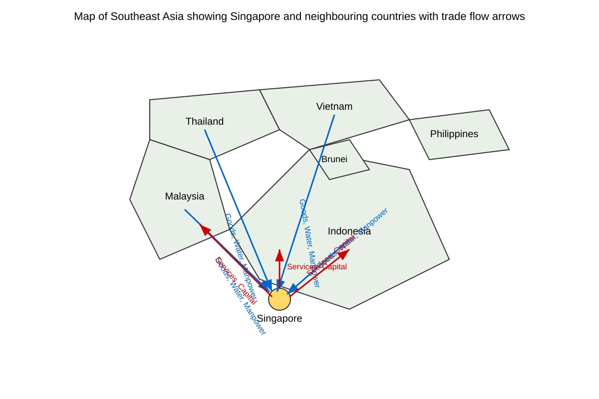
From map:
- Arrows in show resources (goods/water/manpower) to SG. (2m + label)
- Arrows out show SG exports services/capital. (2m + label)
- Centre position shows hub role. (1m)
Image must show labelled arrows as described.