AI Generated Exam Paper
Secondary 3 Geography Practice Paper 2
Free Sec 3 Geography Practice Paper 2, Kimi2.6 AI version, with questions, answers, and O Level-style practice for Singapore students.
These static practice materials are generated from the site's syllabus and paper-generation workflow, with source and model context shown so students and parents can evaluate the material before use.
Questions
TuitionGoWhere Practice Paper - Geography Secondary 3
TuitionGoWhere Practice Paper (AI)
Version 2 of 5
Subject: Geography
Level: Secondary 3
Paper: Practice Paper
Duration: 1 hour 15 minutes
Total Marks: 60
Name: _______________________________ Class: ______________ Date: ______________
INSTRUCTIONS
- Answer ALL questions.
- Write your answers in the spaces provided.
- For questions requiring calculations, show all working clearly.
- Use geographical terminology accurately.
- For map and graph questions, refer to the relevant
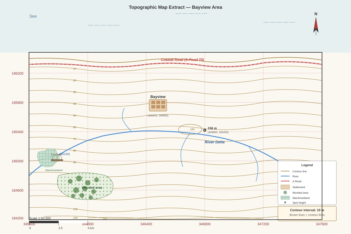
Generated map for Q1.
(a) Give the six-figure grid reference of the settlement centre of Bayview.
[1]
(b) Calculate the straight-line distance in kilometres from the settlement centre of Bayview (346450, 184850) to the river mouth (346200, 185100). Show your working.
[3]
Working:
Answer: ____________________ km
(c) Describe the relief of the area shown on the map extract.
[3]
2. Study the weather map below.
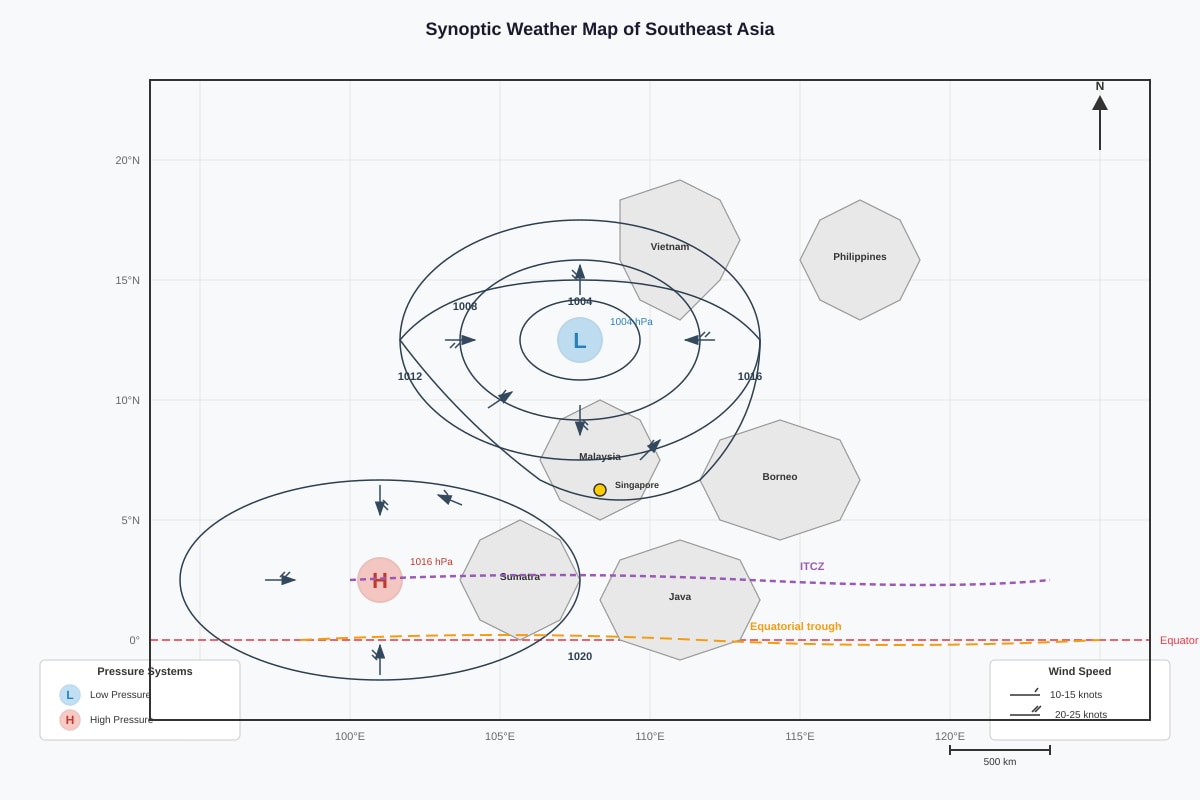
Generated map for Q2.
(a) Identify the pressure system located over the South China Sea.
[1]
(b) Referring to the wind arrows, describe the wind direction blowing towards Singapore.
[2]
(c) Explain why the Inter-tropical Convergence Zone (ITCZ) is associated with heavy rainfall.
[3]
3. Study the choropleth map below showing population density.
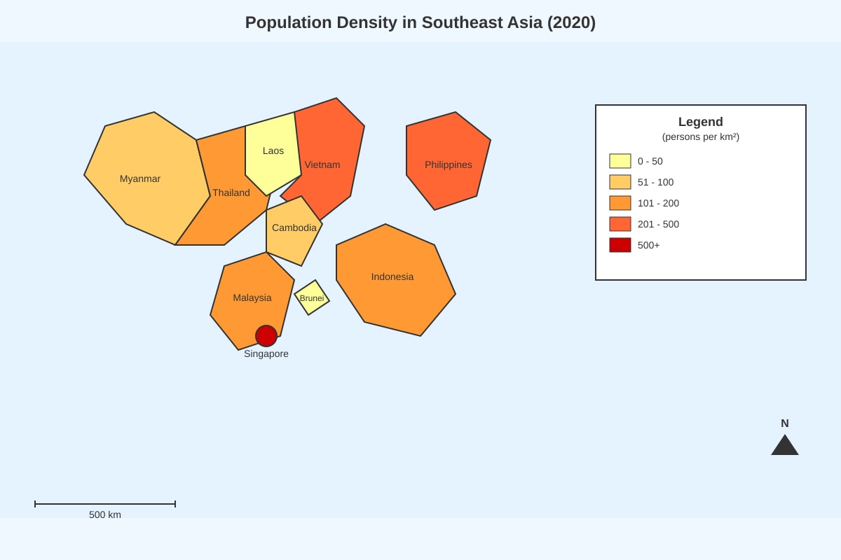
Generated map for Q3.
(a) Which country has the highest population density according to the map?
[1]
(b) Suggest two reasons why Singapore has a very high population density.
[4]
(c) Explain one limitation of using a choropleth map to show population density.
[2]
4. Study the land use map below.
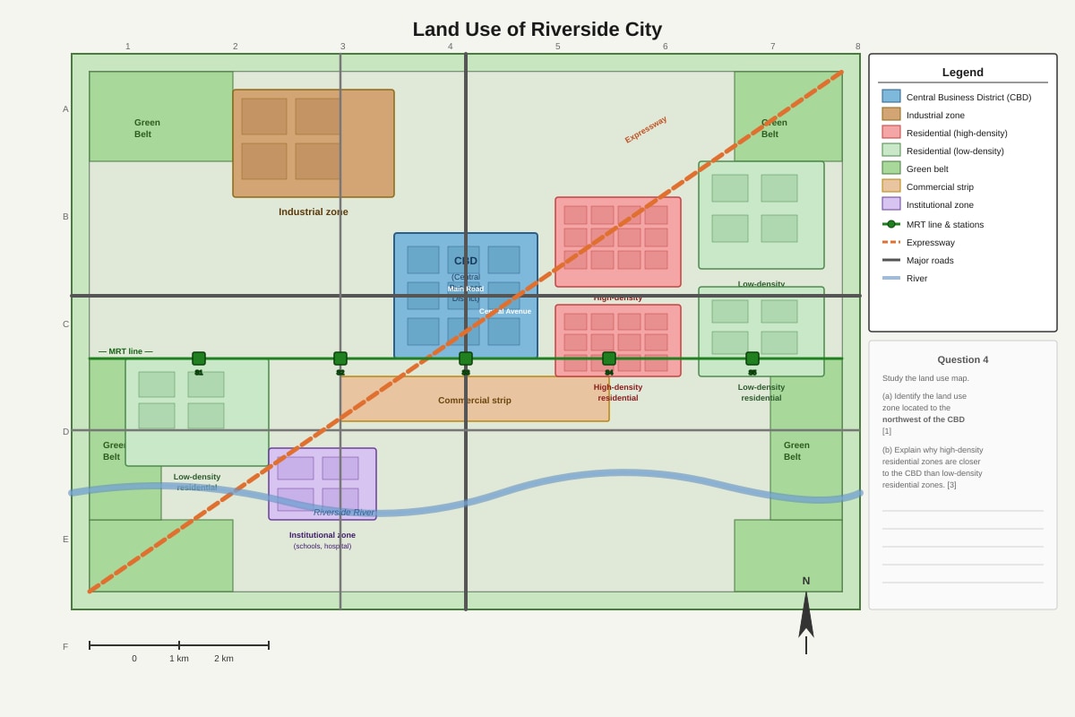
Generated map for Q4.
(a) Identify the land use zone located to the northwest of the CBD.
[1]
(b) Explain why high-density residential zones are located closer to the CBD than low-density residential zones.
[3]
SECTION B: Graph and Data Interpretation (Questions 5–14, 25 marks)
Answer ALL questions. Write your answers in the spaces provided.
5. Study the climate graph below.
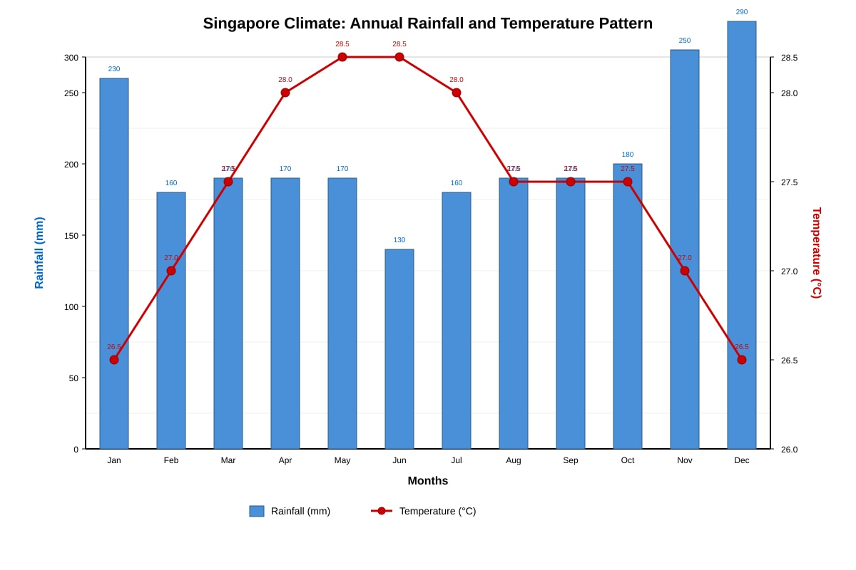
Generated graph for Q5.
(a) Which month has the highest rainfall?
[1]
(b) Calculate the total annual rainfall. Show your working.
[2]
Working:
Answer: ____________________ mm
(c) Explain why Singapore experiences relatively uniform temperatures throughout the year.
[3]
6. Study the population pyramid below.
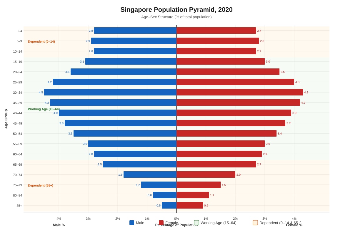
Generated graph for Q6.
(a) Calculate the approximate dependency ratio for Singapore in 2020. Show your working.
Dependency ratio = [(Population aged 0-14 + Population aged 65+) ÷ Population aged 15-64] × 100
[4]
Working:
Answer: ____________________ %
(b) Describe two characteristics of Singapore's population structure shown in the pyramid.
[4]
7. Study the scatter graph below showing the relationship between GDP per capita and life expectancy.
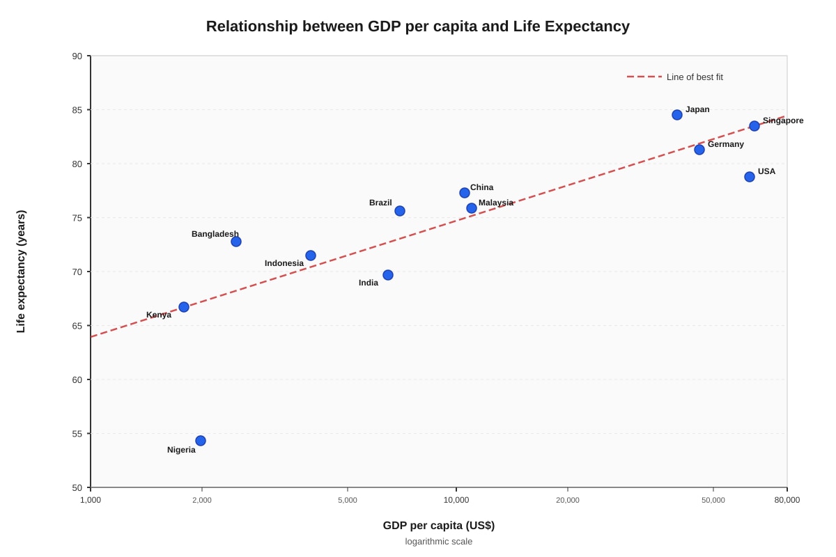
Generated graph for Q7.
(a) Identify the country with the highest GDP per capita on the graph.
[1]
(b) Describe the overall relationship between GDP per capita and life expectancy shown in the graph.
[2]
(c) Suggest one reason why life expectancy may not be high in a country with high GDP per capita.
[2]
8. Study the table below showing tourist arrivals in Southeast Asia.
| Country | 2015 (millions) | 2019 (millions) | 2022 (millions) |
|---|---|---|---|
| Thailand | 29.9 | 39.8 | 11.2 |
| Malaysia | 25.7 | 26.1 | 7.4 |
| Singapore | 15.2 | 19.1 | 5.7 |
| Indonesia | 10.4 | 16.1 | 4.6 |
| Vietnam | 7.9 | 18.0 | 10.3 |
| Philippines | 5.4 | 8.3 | 2.7 |
(a) Calculate the percentage change in tourist arrivals for Singapore between 2019 and 2022. Give your answer to one decimal place. Show your working.
[3]
Working:
Answer: ____________________ %
(b) Suggest two reasons for the change in tourist arrivals between 2019 and 2022 for the region.
[4]
9. Study the line graph below showing urbanisation rates.
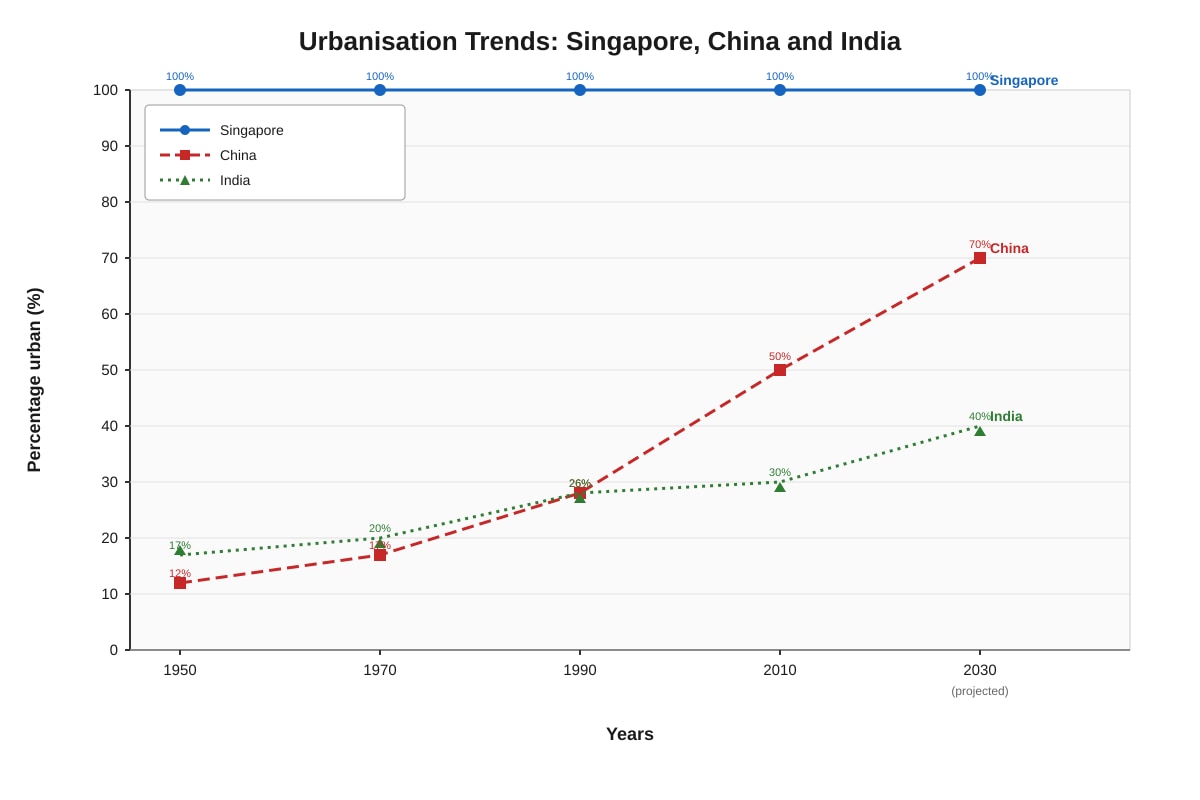
Generated graph for Q9.
(a) Describe the trend in urbanisation for China between 1950 and 2030.
[2]
(b) Explain why Singapore's urbanisation rate has remained at 100% over the entire period.
[2]
10. Study the pie chart below showing energy consumption sources.
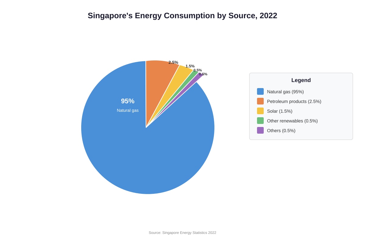
Generated chart for Q10.
(a) What percentage of Singapore's energy consumption comes from natural gas?
[1]
(b) Explain two challenges Singapore faces in increasing its use of renewable energy.
[4]
SECTION C: Data Response and Synthesis (Questions 11–14, 10 marks)
Answer ALL questions. Write your answers in the spaces provided.
11. Study the data table and graph below showing temperature and tourist arrivals at a beach resort.
Table: Monthly Temperature and Tourist Arrivals
| Month | Mean Temperature (°C) | Tourist Arrivals (thousands) |
|---|---|---|
| January | 32 | 45 |
| February | 33 | 52 |
| March | 34 | 68 |
| April | 35 | 85 |
| May | 34 | 72 |
| June | 33 | 58 |
| July | 32 | 48 |
| August | 32 | 44 |
| September | 33 | 50 |
| October | 34 | 62 |
| November | 33 | 55 |
| December | 32 | 47 |
Image pending generation: graph for Q11.
(a) Describe the relationship between temperature and tourist arrivals shown in the data.
[3]
(b) Suggest one other factor (other than temperature) that might affect tourist arrivals at a beach resort. Explain your answer.
[2]
12. Study the composite map and graph below.
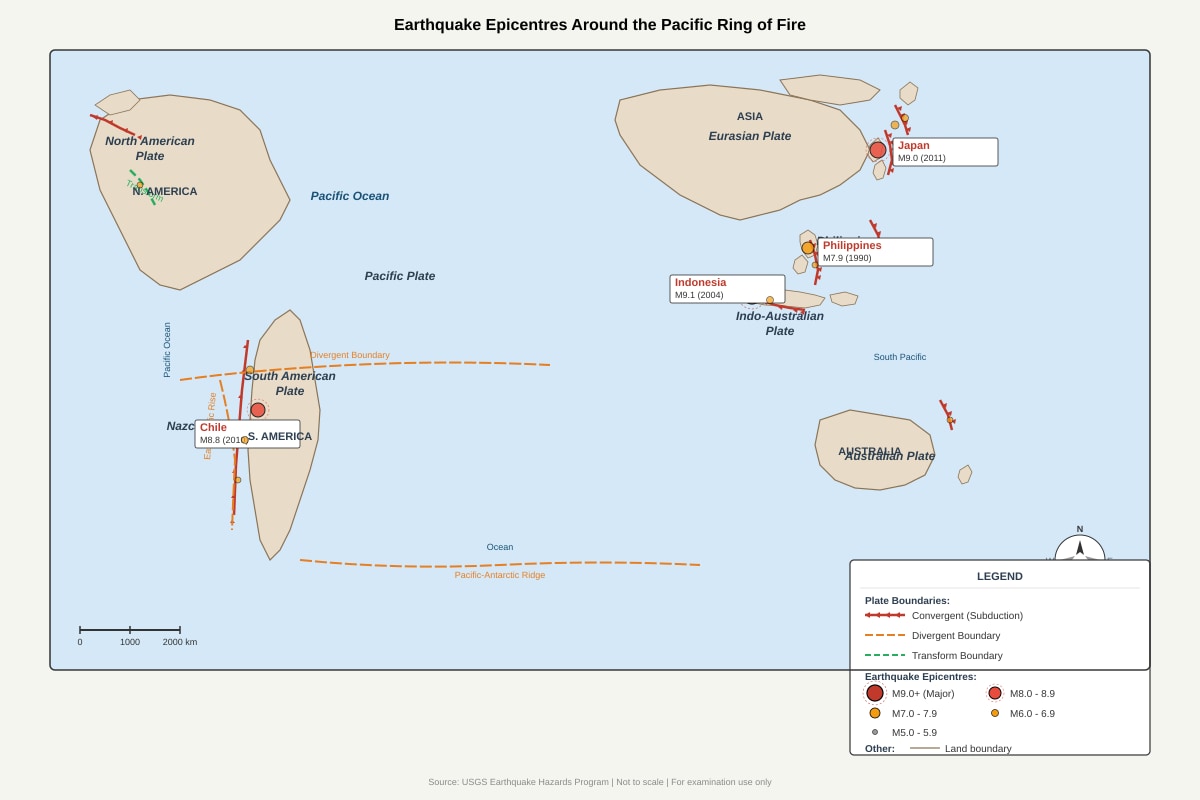
Generated map for Q12.
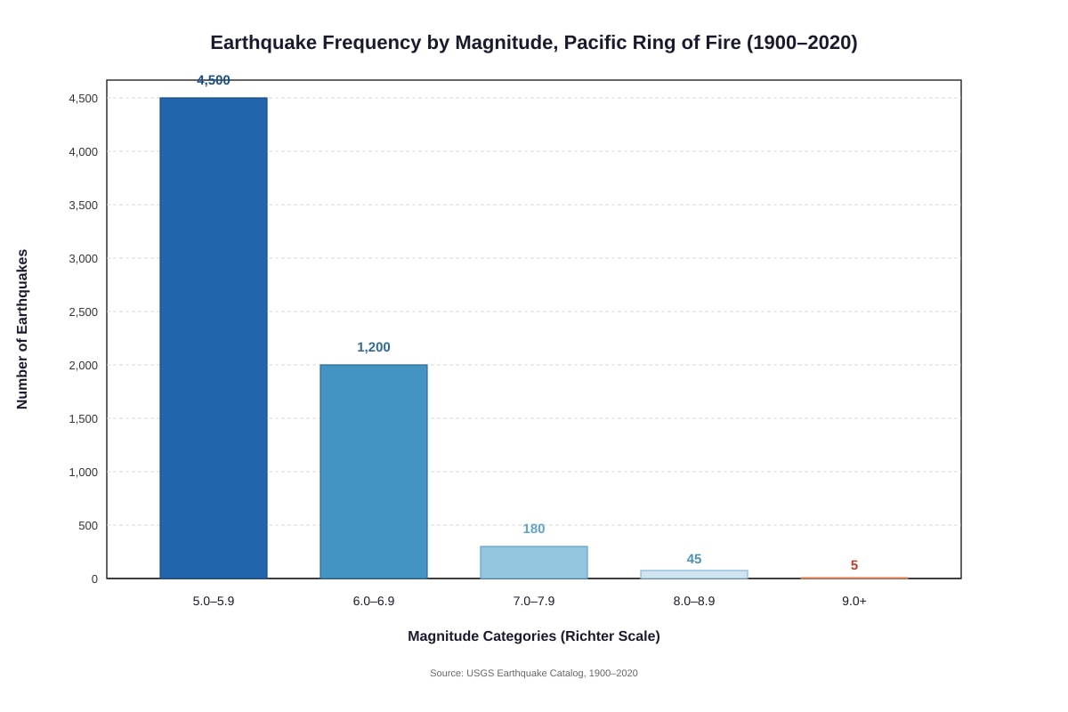
Generated graph for Q12.
(a) Using evidence from both sources, explain why the Pacific Ring of Fire has frequent earthquakes.
[3]
13. The table below shows data for two countries.
| Indicator | Country A | Country B |
|---|---|---|
| GDP per capita (US$) | 2,400 | 56,000 |
| Life expectancy (years) | 65 | 83 |
| Infant mortality rate (per 1,000 births) | 42 | 2 |
| Literacy rate (%) | 72 | 99 |
| Access to clean water (%) | 68 | 100 |
| HDI value | 0.55 | 0.95 |
(a) Identify which country is more developed using evidence from the table.
[1]
(b) Explain why GNI per capita alone is not a good indicator of development. Use evidence from the table or your knowledge.
[4]
14. Study the data below on Singapore's water supply.
| Source | 1960s (%) | 2020s (%) |
|---|---|---|
| Imported water (Malaysia) | 80 | 25 |
| Local catchment | 15 | 30 |
| NEWater (recycled) | 0 | 30 |
| Desalinated water | 0 | 15 |
(a) Describe the main change in Singapore's water supply sources between the 1960s and 2020s.
[2]
(b) Explain why Singapore has sought to diversify its water sources.
[2]
END OF PAPER
Answers
TuitionGoWhere Practice Paper - Answer Key
TuitionGoWhere Practice Paper (AI)
Version 2 of 5
Subject: Geography
Level: Secondary 3
Paper: Practice Paper
Total Marks: 60
SECTION A: Map Skills and Interpretation (25 marks)
1(a) 346450, 184850 (or 346450 184850)
[1 mark]
- Accept answers with or without comma/space between easting and northing.
- Must have 6 figures for each coordinate.
1(b) Distance calculation:
[3 marks]
Working (method):
- Grid difference eastings: 346450 − 346200 = 250 metres (east-west distance) [0.5]
- Grid difference northings: 185100 − 184850 = 250 metres (north-south distance) [0.5]
- Using Pythagoras' theorem: √(250² + 250²) = √125000 = 353.55... metres [1]
- Convert to km: 353.55 ÷ 1000 = 0.354 km (accept 0.35–0.36 km) [1]
Answer: 0.35 km (accept 0.354 km or 0.4 km to 1 decimal place)
Common error: Students may simply add 250 + 250 = 500 m = 0.5 km. This scores marks for grid difference only (max 1 mark), not for correct distance method.
1(c) Relief description:
[3 marks]
Any three valid points:
- The area is generally flat to gently sloping near the coast and river mouth [1]
- Relief becomes more hilly/steep inland to the northeast (spot height 156m) [1]
- The highest point is 156m (from spot height/contour reading) [1]
- There is a gradual rise in elevation from northwest to southeast/northeast [1]
- The settlement and river mouth are located in low-lying areas (0–20m) [1]
- The wooded area coincides with steeper/higher ground [1]
Marking note: Need specific evidence from map (heights, directions, features) for full marks. General descriptions without map evidence score max 2.
2(a) Low pressure system / Depression / Tropical low
[1 mark]
2(b) Wind direction:
[2 marks]
- The wind is blowing from a southwesterly/ southeasterly direction towards Singapore [1]
- Winds spiral inwards and anticlockwise (in Northern Hemisphere) towards the low pressure centre [1]
- More specific: winds approach Singapore from the south or southwest, bringing moist maritime air [1]
Accept: "From the sea towards land" or "southwesterly" with explanation.
2(c) ITCZ and heavy rainfall:
[3 marks]
- The ITCZ is where northeast and southeast trade winds converge [1]
- The converging winds are heated strongly by intense tropical insolation [1]
- This causes air to rise rapidly (convection), leading to cooling, condensation, and cloud formation [1]
- The rising air creates low pressure and unstable conditions, producing heavy convective rainfall/thunderstorms [1]
- The zone is also associated with the monsoon system, bringing seasonally heavy rain to Southeast Asia [1]
Any 3 points.
3(a) Singapore
[1 mark]
3(b) Reasons for Singapore's high population density:
[4 marks]
Any two points, with explanation:
- Small land area [1]: Singapore has only approximately 734 km² of land, so even with a moderate population, the density is very high [1]
- High urbanisation/limited rural areas [1]: Nearly all of Singapore is urbanised with little agricultural or undeveloped land, concentrating people in built-up areas [1]
- Economic opportunities attract immigrants [1]: Singapore's developed economy draws foreign workers and talents, adding to population [1]
- Historical settlement patterns [1]: As a colonial port city, Singapore developed as a concentrated trading centre [1]
3(c) Limitation of choropleth maps:
[2 marks]
Any one limitation with explanation:
- Assumes uniform density within each country [1]: In reality, population is concentrated in cities (e.g., Jakarta in Indonesia, Bangkok in Thailand), while rural areas are sparse [1]
- Boundaries are arbitrary political lines [1]: Natural population distribution doesn't follow country borders [1]
- Colour shading can be misleading [1]: Small countries like Singapore may be hard to distinguish; colour intensity can exaggerate differences [1]
- Only shows one variable [1]: Doesn't explain why density differs (economic, physical factors) [1]
4(a) Industrial zone
[1 mark]
4(b) Why high-density residential zones are closer to CBD:
[3 marks]
- Land rent theory [1]: Land nearer the CBD has higher rents/rents are bid up by commercial users; high-density housing (flats/apartments) is more land-efficient, allowing more people to live on expensive land [1]
- Accessibility/transport costs [1]: Workers need to commute to jobs in the CBD; living closer reduces time and transport costs [1]
- Historical development [1]: Cities often grew from the centre outward, with older, denser housing near original urban core [1]
- Infrastructure capacity [1]: Urban infrastructure (water, electricity, transport) is concentrated in central areas, supporting denser development [1]
Any 2-3 points with development.
SECTION B: Graph and Data Interpretation (25 marks)
5(a) December
[1 mark]
5(b) Total annual rainfall calculation:
[2 marks]
Working: 230 + 160 + 170 + 170 + 170 + 130 + 160 + 170 + 170 + 180 + 250 + 290
= 2300 mm [1 for correct method of summing all months; 1 for correct answer]
Accept 2290–2310 mm if minor addition errors.
5(c) Uniform temperatures:
[3 marks]
- Equatorial location [1]: Singapore is located near the equator (approximately 1°N), so the sun is always high in the sky throughout the year; solar intensity varies little [1]
- Consistent day length [1]: Near the equator, day and night are roughly equal (12 hours) all year, unlike temperate zones with seasonal variation [1]
- Maritime influence [1]: Surrounded by sea, the ocean moderates temperature extremes; water heats and cools slowly, stabilising air temperatures [1]
- Small annual temperature range [1]: Typically 1–2°C between hottest and coolest months, compared to 15–20°C+ in temperate regions [1]
Any 3 points.
6(a) Dependency ratio calculation:
[4 marks]
Step-by-step working:
Step 1: Calculate young dependents (0–14)
- Males: 2.8 + 2.9 + 2.8 = 8.5% [0.5]
- Females: 2.7 + 2.8 + 2.7 = 8.2% [0.5]
- Total young dependents: 8.5 + 8.2 = 16.7% [0.5]
Step 2: Calculate elderly dependents (65+)
- Males: 2.5 + 1.8 + 1.2 + 0.8 + 0.5 = 6.8% [0.5]
- Females: 2.7 + 2.0 + 1.5 + 1.1 + 0.9 = 8.2% [0.5]
- Total elderly dependents: 6.8 + 8.2 = 15.0% [0.5]
Step 3: Calculate working age (15–64)
- Method: 100% − 16.7% − 15.0% = 68.3%
- Alternative by summing: approximately 68.3% [0.5]
Step 4: Apply formula
- Dependency ratio = [(16.7 + 15.0) ÷ 68.3] × 100
- = [31.7 ÷ 68.3] × 100
- = 46.4% (accept 45–48% depending on rounding) [1]
Alternative acceptable method: If student uses rounded figures or calculates total dependency ratio differently, award marks for correct method.
Common error: Forgetting to include both males and females, or using wrong age ranges.
6(b) Two characteristics of Singapore's population structure:
[4 marks]
Any two, with description and evidence:
-
Narrow base/declining fertility [1]: The bottom age groups (0–4, 5–9, 10–14) are narrower than working-age bars [1]; this indicates below-replacement fertility with fewer young children [1]
-
Bulge in working-age population/ageing population [1]: The pyramid bulges in 25–39 and 50–54 age ranges [1], reflecting past baby booms and immigration of working-age adults [1]
-
Increasing proportion of elderly [1]: Bars widen again in 65+ for females, showing longer female life expectancy and ageing society [1]; this creates future dependency challenges [1]
-
Relatively balanced sex ratio [1]: Male and female bars are similar in length for most age groups, with slight male surplus in working ages due to foreign workers [1]
Max 2 characteristics, each with description and pyramid evidence.
7(a) Singapore (or USA, which is very close; accept Singapore as clearly highest on graph at $65,000)
[1 mark]
Note: If student says USA based on 63,000vs65,000, accept if they explain close values. Singapore is marginally higher.
7(b) Overall relationship:
[2 marks]
- Positive correlation [1]: As GDP per capita increases, life expectancy generally increases [1]
- The relationship is not perfectly linear [1]: At lower income levels, small increases in GDP bring large gains in life expectancy; at higher levels, the curve flattens (diminishing returns) [1]
- Logarithmic pattern [1]: The x-axis is logarithmic; on a linear scale, the relationship would appear even more curved with most gains at lower incomes [1]
Any 2 points.
7(c) Reason for high GDP but not highest life expectancy:
[2 marks]
Any one reason with explanation:
- Lifestyle factors [1]: USA has high obesity rates, drug abuse, and gun violence that reduce average life expectancy despite wealth [1]
- Inequality [1]: High GDP per capita may mask unequal distribution; poor healthcare access for some groups reduces national average [1]
- Healthcare system differences [1]: Some high-GDP countries lack universal healthcare, affecting outcomes [1]
- Diet and culture [1]: Dietary habits, work culture (stress), and social isolation in wealthy nations may affect health [1]
8(a) Percentage change for Singapore:
[3 marks]
Formula: [(New Value − Original Value) ÷ Original Value] × 100 [0.5]
Working:
- Change: 5.7 − 19.1 = −13.4 million [0.5]
- Percentage change: (−13.4 ÷ 19.1) × 100 [0.5]
- = −70.2% (accept −70.1% to −70.3%) [1]
Answer: 70.2% decrease or −70.2%
8(b) Two reasons for change:
[4 marks]
Primary reason (COVID-19 pandemic):
- COVID-19 pandemic (2020–2022) [1]: Global travel restrictions, border closures, and quarantine requirements drastically reduced international tourism [1]; Singapore closed borders for extended periods [1]
Secondary reasons:
- Economic recession [1]: Global economic downturn reduced disposable income for travel [1]
- Fear of infection/health concerns [1]: Tourists avoided travel due to virus transmission risks [1]
- Collapse of business travel [1]: Meetings moved online, reducing a key Singapore market [1]
Must reference pandemic for full marks; other valid contextual reasons accepted if well-explained.
9(a) China's urbanisation trend:
[2 marks]
- Rapid acceleration [1]: From 12% in 1950 to projected 70% in 2030; particularly fast since 1990 (26% to 70%) [1]
- Slower initial period [1]: Relatively flat 1950–1990 due to Communist policies restricting migration (hukou system), then rapid post-reform growth [1]
- Catching up to developed levels [1]: Approaching rates seen in fully urbanised countries like Singapore [1]
Any 2 points with trend description.
9(b) Singapore 100% urbanisation:
[2 marks]
- City-state [1]: Singapore is entirely a single city with no rural hinterland or agricultural land; by definition, all population is urban [1]
- Complete land use conversion [1]: Nearly all land has been developed for urban uses (housing, industry, commerce); no traditional rural villages or farmland remain [1]
- Administrative definition [1]: Even peripheral areas like Pulau Ubin are considered part of the urban administrative area [1]
Any 2 points.
10(a) 95%
[1 mark]
10(b) Two challenges for renewable energy in Singapore:
[4 marks]
Any two, with explanation:
-
Limited land area [1]: Singapore is very small (734 km²); solar farms require large land areas that compete with housing, industry, and green space [1]; rooftop solar helps but is insufficient for total demand [1]
-
Lack of natural renewable resources [1]: No significant rivers for hydroelectric power, no consistent strong winds for wind power, no geothermal activity [1]; geography limits options to mainly solar [1]
-
High cloud cover and humidity [1]: Equatorial location brings frequent rain and haze, reducing solar panel efficiency compared to desert climates [1]
-
Energy storage/ intermittency [1]: Solar energy is only generated in daylight; storing excess requires expensive battery technology not yet fully developed at scale [1]
-
High energy demand from industry [1]: Dense manufacturing base (petrochemicals, electronics) requires reliable baseload power that renewables alone cannot yet provide [1]
SECTION C: Data Response and Synthesis (10 marks)
11(a) Relationship between temperature and tourist arrivals:
[3 marks]
- Positive correlation up to April, then negative [1]: Arrivals increase with temperature from January (32°C, 45,000) to April (35°C, 85,000), then decrease as temperature stays high or rises further [1]
- Peak in April [1]: Optimal temperature appears to be around 34–35°C; beyond this, higher temperatures do not attract more tourists [1]
- Decline in hottest months [1]: May–August show sustained high temperatures (32–34°C) but falling arrivals, suggesting other factors (monsoon rainfall, school holidays in source countries) matter [1]
- Not a simple linear relationship [1]: The data suggests tourists prefer warm but not excessively hot conditions; comfort zone exists [1]
Any 3 developed points with data evidence.
11(b) Other factor affecting tourist arrivals:
[2 marks]
Any one factor with explanation:
- Rainfall/monsoon season [1]: Heavy rainfall during monsoon months (November–January in many tropical areas) reduces beach appeal despite warm temperatures [1]
- School holidays/seasonal travel patterns [1]: Tourist arrivals often peak during Northern Hemisphere school holidays (Easter, summer) regardless of local weather [1]
- Cost/flight prices [1]: Airfare costs and package deals vary seasonally, affecting demand [1]
- Events and festivals [1]: Special events attract visitors at specific times [1]
- Safety/political stability [1]: Health scares or unrest deter tourists [1]
12(a) Why Pacific Ring of Fire has frequent earthquakes:
[3 marks]
- Plate boundaries/convergent margins [1]: The map shows numerous convergent/subduction zones where oceanic plates meet continental plates (e.g., Pacific Plate subducting under Eurasian Plate near Japan) [1]
- Subduction creates stress [1]: The graph shows high frequency of 5.0–5.9 earthquakes (4500); this constant minor activity reflects ongoing plate movement and stress accumulation [1]
- Major earthquakes at subduction zones [1]: The 9.0, 9.1, and 8.8 magnitude earthquakes occur exactly where subduction happens (Japan, Indonesia, Chile), showing these boundaries generate the largest releases of accumulated energy [1]
- High frequency overall [1]: The Ring of Fire accounts for ~90% of world's earthquakes; the bar graph's high totals in all categories confirm this concentration [1]
Must integrate both sources for full marks.
13(a) Country B
[1 mark]
All indicators consistently higher; HDI 0.95 vs 0.55 clearly indicates high development.
13(b) Why GNI/GDP per capita alone is insufficient:
[4 marks]
- Does not show income distribution [1]: Country A could have wealthy elite with poor majority; GDP per capita is an average that hides inequality [1]
- Does not reflect social development [1]: Country B has 99% literacy vs 72%; Country A's lower literacy limits human capital development despite some economic activity [1]
- Does not capture health outcomes [1]: Life expectancy (65 vs 83) and infant mortality (42 vs 2) show major quality-of-life differences not visible in economic data [1]
- Quality of life includes non-economic factors [1]: Access to clean water (68% vs 100%), environmental quality, political freedom, and security matter for development [1]
- HDI is more comprehensive [1]: HDI combines income, education, and health, giving better comparison; Country B's 0.95 vs Country A's 0.55 shows this multidimensional gap [1]
Any 4 points, or 2 well-developed points with examples.
14(a) Main change in water supply:
[2 marks]
- Reduced dependence on imported water [1]: From 80% to 25%, a dramatic decline in reliance on Malaysian imports [1]
- Diversification into new sources [1]: Introduction of NEWater (30%) and desalination (15%) that did not exist in the 1960s [1]; local catchment also doubled from 15% to 30% [1]
- Four sources now (Four National Taps) vs mainly one source previously [1]
Any 2 developed points.
14(b) Why Singapore diversified water sources:
[2 marks]
- Water security/self-sufficiency [1]: Political relationship with Malaysia uncertain; 1961 and 1962 water agreements were finite; need to reduce vulnerability to external supply disruption [1]
- Increasing demand [1]: Population and industrial growth increased water needs beyond what imports and limited catchment could reliably provide [1]
- Climate change uncertainty [1]: Droughts could reduce Malaysian supply; needed resilient domestic sources [1]
- Technological advancement [1]: Development of membrane technology made NEWater and desalination economically viable [1]
Any 2 points.
END OF ANSWER KEY
Total marks checked: 60
| Section | Marks |
|---|---|
| A (Q1-4) | 25 |
| B (Q5-10) | 25 |
| C (Q11-14) | 10 |
| Total | 60 |
Free quiz and exam paper access
Enter your details to view this paper
Your access is remembered on this device.