AI Generated Quiz
Secondary 2 Geography Physical Geography Quiz
Free Sec 2 Geography Physical Geography quiz, HY3 AI version, with questions, answers, and syllabus-aligned practice for Singapore students.
These static practice materials are generated from the site's syllabus and paper-generation workflow, with source and model context shown so students and parents can evaluate the material before use.
Questions
Free quiz and exam paper access
Enter your details to view this paper
Your access is remembered on this device.
Answers
Secondary 2 Geography Quiz - Physical Geography (Answer Key)
Total Marks: 40
Topic: Physical Geography (Stage 5 AI-generated, syllabus-first; not claimed as past-year derived)
Q1. [1 mark] C. Biosphere
Teaching note: The biosphere is the sphere that contains all living things (plants, animals, microbes). Atmosphere = air; lithosphere = solid earth/rocks; hydrosphere = water. Common mistake: confusing biosphere with hydrosphere.
Q2. [1 mark] Condensation
Teaching note: Cooling of water vapour → liquid droplets = condensation, forming clouds. Evaporation is the reverse (liquid → vapour).
Q3. [1 mark] Solid
Teaching note: Glaciers are frozen water, so the state is solid. Other states: liquid (oceans), gas (water vapour).
Q4. [2 marks] Any two of: oceans, glaciers, rivers, lakes, groundwater, atmosphere (water vapour). [1 mark each]
Teaching note: These are stores in the hydrological cycle. Mark both correctly named stores.
Q5. [1 mark] Water budget
Teaching note: Water budget = balance of inputs (rain) and outputs (evaporation, runoff) in a catchment.
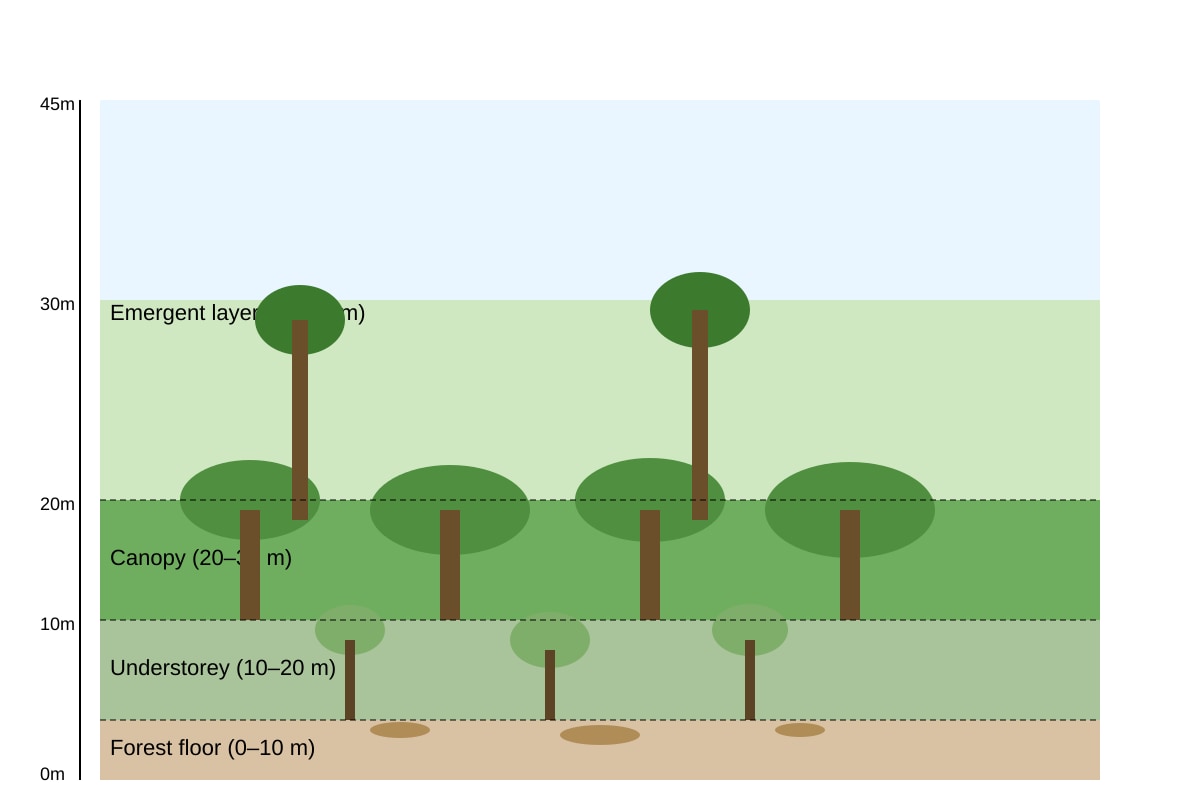
Q6. [1 mark] Emergent layer
Teaching note: From the placeholder diagram, the tallest layer with trees above canopy is the emergent layer (30–45 m). Common mistake: writing "canopy".
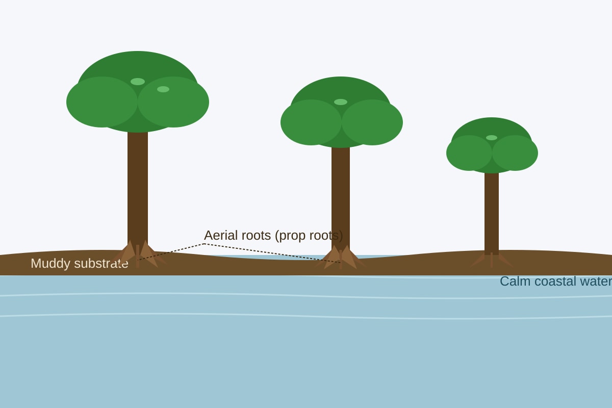
Q7. [1 mark] Aerial roots / prop roots / pneumatophores
Teaching note: These roots stick above mud to take in air (oxygen) since soil is waterlogged.
Q8. [2 marks] Any two of: habitat for biodiversity, carbon storage, oxygen production, erosion protection, climate regulation. [1 mark each]
Teaching note: Rainforests provide many environmental functions; accept clear ecological roles.
Q9. [3 marks] Mark scheme:
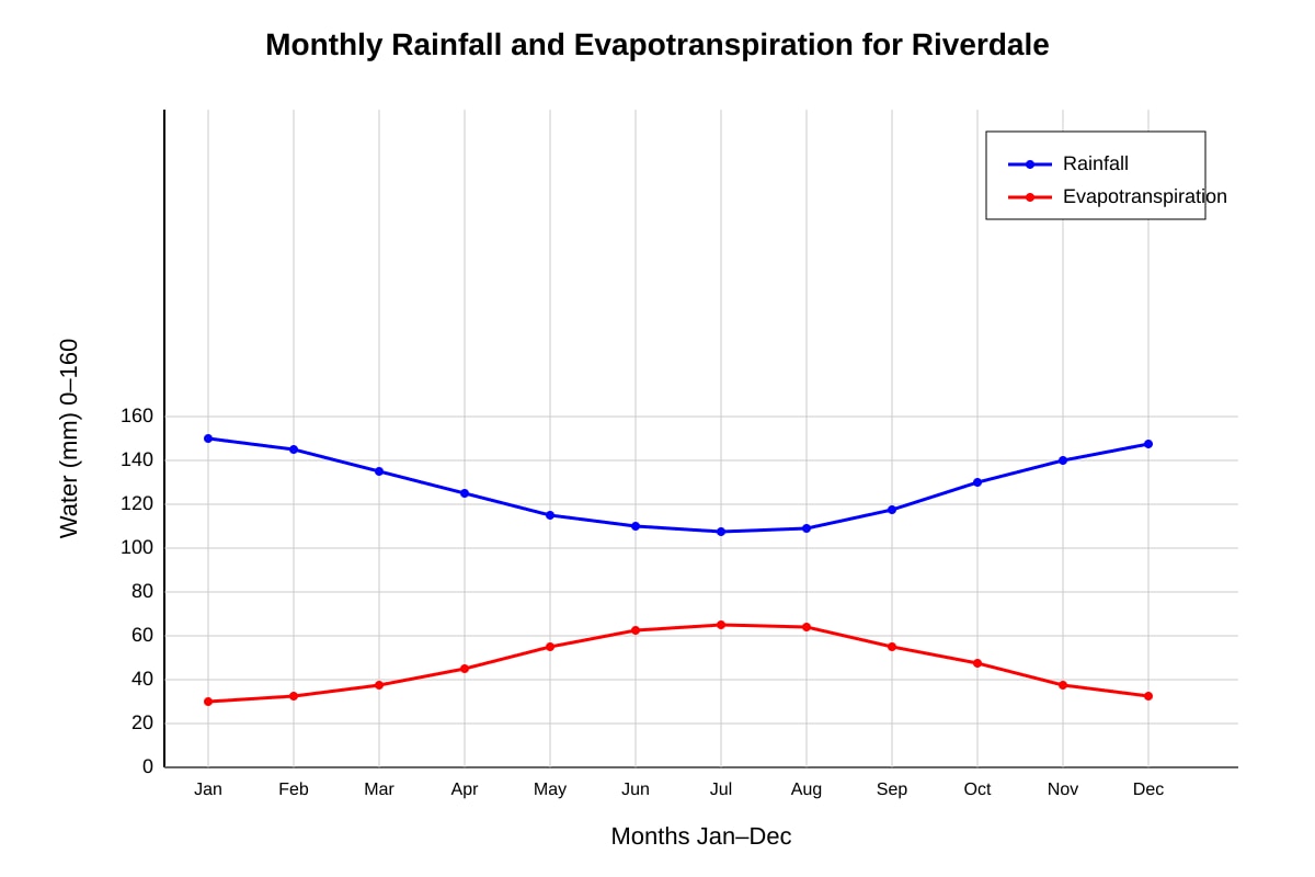
- States overall trend: water surplus decreases from Jan to July (1 mark)
- Uses statistics: Jan surplus = 120–60 = 60 mm; July rainfall 35 < evapotranspiration 130 → deficit of 95 mm (1 mark)
- Notes crossing point: by May/Jun rainfall < evapotranspiration (1 mark)
Teaching note: Water surplus = rainfall − evapotranspiration. In Jan it is +60 mm, shrinking to negative by Jul. Student must refer to numbers.
Q10. [2 marks] (a) June (b) July [1 mark each]
Teaching note: Jun: 40 < 125; Jul: 35 < 130. Also May and Aug close but May rain 50<110, Aug 38<128 — accept May, Jun, Jul, Aug if consistent; best two clearly deficit: Jun, Jul.
Q11. [3 marks]
- Description: visible aerial/prop roots above water (1 mark)
- Explanation: allows gas exchange in oxygen-poor muddy soil (1 mark)
- Context: helps survival in waterlogged coastal conditions (1 mark)
Teaching note: From photo, roots are adaptation for breathing; link to environment.
Q12. [3 marks]
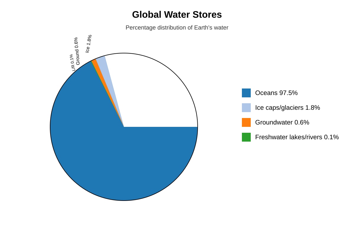
Working: Total = 100%. Usable lakes/rivers = 0.1%. Not usable = 100 − 0.1 = 99.9% (2 marks for working + answer).
Teaching note: Most water is salty ocean or locked in ice; only 0.1% is accessible freshwater surface water.
Q13. [2 marks]
- Near Equator temperatures are high all year (1 mark)
- High temperatures cause high evaporation → frequent convectional rainfall (1 mark)
Teaching note: Tropics have warm, wet climate suitable for rainforests.
Q14. [3 marks]
Calculation: Decrease = (5000 − 3200) / 5000 × 100 = 1800/5000 × 100 = 36% (2 marks).
Explanation: Less forest means less carbon stored, more CO₂ in air (1 mark).
Teaching note: Formula: % decrease = (loss/original)×100. Deforestation releases stored carbon.
Q15. [4 marks] Mark descriptors:
- Defines evaporation: sun heats water → vapour rises (1)
- Links to cloud/rain formation over Singapore (1)
- Connects to local catchment tap: rain fills reservoirs (1)
- Notes without evaporation, no rainfall, supply fails (1)
Teaching note: Evaporation from sea is key to Singapore's local catchment water.
Q16. [4 marks]
- Characteristic: dense continuous roof of trees 20–30 m, blocks light (2)
- Supports biodiversity: many species live/feed there, microhabitats (2)
Teaching note: Canopy is most biologically active layer.
Q17. [4 marks]
- Explains salt secretion removes excess salt from salty water (2)
- Evaluates: effective for survival but limited if salinity extreme / cannot survive long flooding (2)
Teaching note: Adaptation has threshold; not perfect.
Q18. [4 marks] Chain: trees cut → less CO₂ absorbed (1); stored carbon released by burning/decay (1); more atmospheric CO₂ (1); stronger greenhouse effect (1).
Teaching note: Systems thinking: forest loss = carbon source.
Q19. [3 marks]
- Water cycles but distribution uneven (1)
- Humans need accessible freshwater, not salt/ocean (1)
- Local shortages occur despite cycle (1)
Teaching note: Renewable ≠ always available where needed.
Q20. [4 marks]
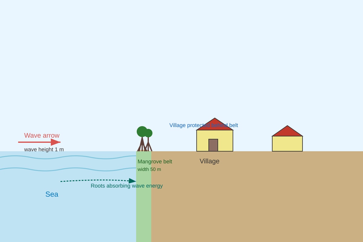
- Roots/trunks absorb wave energy → less erosion (2)
- Limitation: if storms too big or mangroves narrow, protection fails (2)
Teaching note: From diagram, belt buffers village; evaluate limit.