AI Generated Quiz
Secondary 2 Geography Physical Geography Quiz
Free Sec 2 Geography Physical Geography quiz, AI version, with questions, answers, and syllabus-aligned practice for Singapore students.
These static practice materials are generated from the site's syllabus and paper-generation workflow, with source and model context shown so students and parents can evaluate the material before use.
Questions
Free quiz and exam paper access
Enter your details to view this paper
Your access is remembered on this device.
Answers
Secondary 2 Geography Quiz - Physical Geography: Answer Key
Total Marks: 50
Section A: The Water Cycle and Water Resources (Questions 1–5)
1. State the three physical states of water and give one example of where each state is found in the natural environment. [3 marks]
Answer:
- Solid: Ice (e.g., glaciers, ice caps, icebergs, snow) [1 mark]
- Liquid: Water (e.g., rivers, lakes, oceans, groundwater) [1 mark]
- Gas: Water vapour (e.g., in the atmosphere, as steam from hot springs) [1 mark]
Teaching Note: Water is unique because it exists naturally in all three states on Earth. The state depends on temperature. Solid water (ice) is found where temperatures are below 0°C for long periods. Liquid water is the most common form on Earth's surface. Water vapour is invisible and is always present in the air, even if we can't see it. Accept any reasonable example for each state.
Common Mistake: Students sometimes confuse "water vapour" with "steam" (which is actually tiny water droplets, not gas). Water vapour is invisible; what we see as "steam" from a kettle is condensed water droplets.
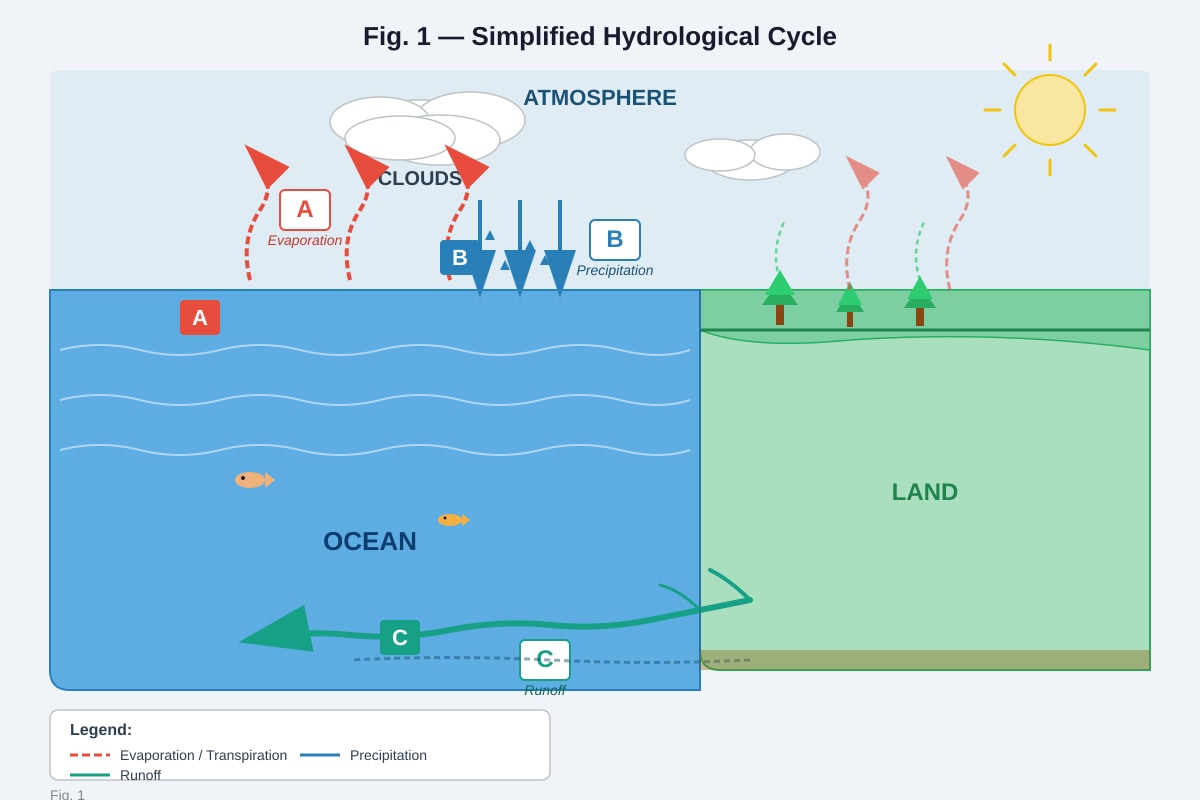
2. Fig. 1 shows a simplified diagram of the hydrological cycle. Identify the processes labelled A, B, and C.
(a) Process A: Evaporation [1 mark] (b) Process B: Precipitation [1 mark] (c) Process C: Runoff (or Surface runoff / River flow) [1 mark]
Teaching Note: The hydrological cycle describes the continuous movement of water between the Earth's surface and the atmosphere.
- Evaporation: Liquid water from oceans, lakes, and rivers turns into water vapour due to solar energy and rises into the atmosphere.
- Precipitation: When water vapour condenses into clouds and falls back to Earth as rain, snow, hail, or sleet.
- Runoff: Water that flows over the land surface into rivers, lakes, and eventually back to the ocean.
Common Mistake: Students often confuse "evaporation" with "transpiration" (water loss from plants). While both are part of "evapotranspiration," the diagram shows evaporation from the ocean surface specifically.
3. Explain why the hydrological cycle is considered a renewable system, even though the total amount of water on Earth is fixed. [2 marks]
Answer: The hydrological cycle is renewable because water is constantly cycled and reused. [1 mark] Although the total amount of water on Earth does not change, the sun's energy continuously drives evaporation, which leads to precipitation, replenishing freshwater sources like rivers and lakes. [1 mark] This means water is not "used up" but rather transformed and moved around the system.
Teaching Note: The key idea is that "renewable" does not mean "infinite" or "new water being created." It means the resource is naturally replenished over a human timescale. The sun provides the energy to keep the cycle going, so as long as the sun shines, the water cycle continues. However, renewable does not mean unlimited — we can still overuse or pollute water faster than the cycle can replenish clean supplies.
Marking Scheme:
- 1 mark for stating the cycle reuses/recycles water
- 1 mark for explaining the role of solar energy or the continuous nature of the cycle
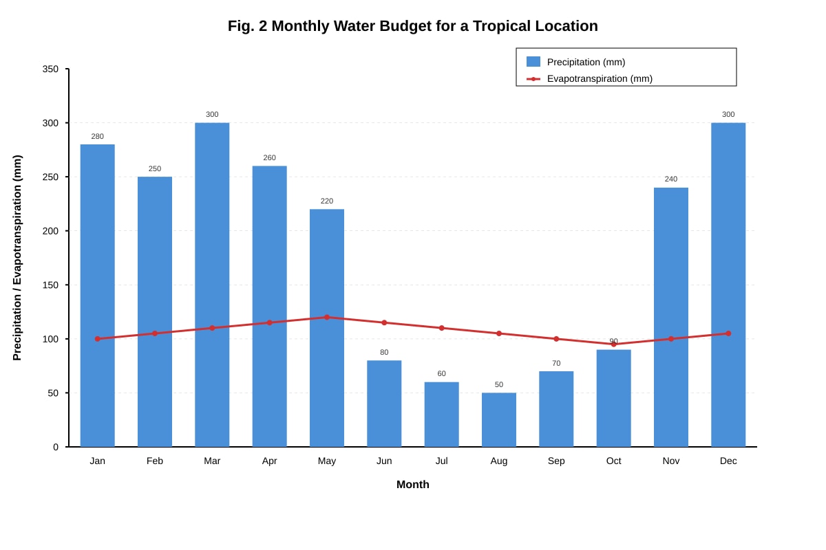
4. Fig. 2 shows the monthly water budget for a tropical location.
(a) In which month(s) does a water surplus occur? Explain your answer. [2 marks]
Answer: A water surplus occurs in months when precipitation exceeds evapotranspiration. [1 mark] From the graph, this happens from November to May (or roughly the wet season months). [1 mark] For example, in January, precipitation (280 mm) is much higher than evapotranspiration (100 mm), creating a surplus of 180 mm.
Teaching Note: Water budget is like a bank account for water. Precipitation is the "income" and evapotranspiration is the "expense." When income > expense, there is a surplus (extra water available for runoff, groundwater recharge, or storage). When expense > income, there is a deficit (water must be drawn from storage).
Marking Scheme:
- 1 mark for identifying the correct months (Nov-May or similar range)
- 1 mark for explaining the condition (P > E) with reference to data
(b) Describe one impact a prolonged water deficit could have on the local environment. [2 marks]
Answer: A prolonged water deficit could lead to drought conditions. [1 mark] This would cause rivers and lakes to dry up, soil moisture to decrease, and plants to wilt or die. [1 mark] It could also increase the risk of wildfires as vegetation becomes dry and flammable.
Teaching Note: A water deficit means the environment is losing more water than it is gaining. Over time, this depletes stored water in soils, rivers, and groundwater. The severity depends on how long the deficit lasts. In the graph, the deficit months (Jun-Oct) are relatively short, so the environment may recover during the wet season. But if deficits continued for years, the area could become a desert.
Marking Scheme:
- 1 mark for identifying a specific impact (drought, reduced river flow, vegetation death)
- 1 mark for explaining the consequence clearly
5. Singapore uses the "Four National Taps" strategy to manage its water supply. Name two of these taps and briefly explain how each one works. [4 marks]
Answer: (Any two of the following four)
Tap 1: Local Catchment Water [1 mark] Explanation: Rainwater is collected from two-thirds of Singapore's land area through a network of drains, canals, and rivers, and stored in 17 reservoirs. [1 mark]
Tap 2: Imported Water [1 mark] Explanation: Singapore imports water from Johor, Malaysia, under a long-term agreement that expires in 2061. [1 mark]
Tap 3: NEWater [1 mark] Explanation: Used water (wastewater) is treated using advanced membrane technologies (microfiltration, reverse ososis, and UV disinfection) to produce high-purity reclaimed water. [1 mark]
Tap 4: Desalination [1 mark] Explanation: Seawater is treated to remove salt and minerals through reverse ososis, producing fresh water. [1 mark]
Teaching Note: The "Four National Taps" strategy is Singapore's approach to water security. It diversifies water sources so that Singapore is not overly dependent on any single source, especially imported water which is vulnerable to political changes. Each tap has different costs and energy requirements — desalination and NEWater are energy-intensive but weather-proof, while local catchment depends on rainfall which is variable.
Marking Scheme:
- 1 mark for each correctly named tap (max 2 taps)
- 1 mark for each correct explanation (max 2 explanations)
- Accept reasonable descriptions even if not perfectly worded
Section B: Tropical Rainforests and Mangroves (Questions 6–10)
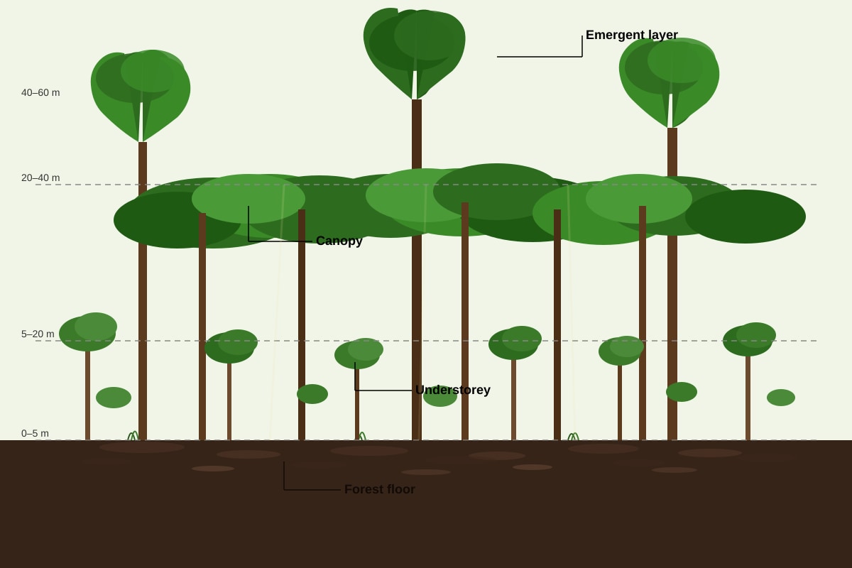
6. Fig. 3 shows the structure of a tropical rainforest.
(a) Identify the layer labelled X (the tallest trees that break through the continuous treetop layer). [1 mark]
Answer: The Emergent layer (or Emergents). [1 mark]
Teaching Note: The emergent layer consists of the tallest trees in the rainforest, reaching heights of 40-60 metres. These trees break through the dense canopy layer below. They are exposed to strong winds, high temperatures, and direct sunlight. They often have buttress roots for support and thick, waxy leaves to reduce water loss.
(b) Explain why the forest floor receives very little sunlight. [2 marks]
Answer: The forest floor receives very little sunlight because the canopy layer is very dense and continuous, blocking out most of the sunlight. [1 mark] The multiple layers of vegetation above (emergent, canopy, understorey) further filter and absorb sunlight, so only about 1-2% of sunlight reaches the forest floor. [1 mark]
Teaching Note: This is why the forest floor is dark and relatively open — few plants can grow there because there is not enough light for photosyntesis. This is also why many rainforest plants have adapted to grow on other plants (epiphytes) to reach sunlight higher up.
Marking Scheme:
- 1 mark for identifying the canopy as the main blocking layer
- 1 mark for explaining the multi-layer filtering effect or giving a specific percentage
7. Describe two adaptations of mangrove trees that allow them to survive in saltwater conditions. [4 marks]
Answer: (Any two of the following)
Adaptation 1: Salt-secreting leaves [1 mark] Explanation: Some mangrove species have special glands on their leaves that excrete excess salt, allowing them to remove salt from their tissues. [1 mark]
Adaptation 2: Aerial roots (pneumatophores) [1 mark] Explanation: Mangroves have specialized roots that grow upward out of the waterlogged soil to obtain oxygen for respiration, since the soil has very little oxygen. [1 mark]
Adaptation 3: Prop roots / Stilt roots [1 mark] Explanation: These roots grow from the trunk and branches into the mud, providing stability in soft, unstable sediments and also helping with gas exchange. [1 mark]
Adaptation 4: Vivipary (seed germination on parent tree) [1 mark] Explanation: Mangrove seeds germinate while still attached to the parent tree, growing into a propagule that can float and take root quickly when it lands in suitable mud. [1 mark]
Teaching Note: Mangroves are halophytes (salt-tolerant plants). They face two main challenges: (1) high salinity that would kill most plants, and (2) waterlogged, oxygen-poor soil. Their adaptations address both challenges. Different mangrove species have different combinations of these adaptations.
Marking Scheme:
- 1 mark for each correctly named adaptation (max 2)
- 1 mark for each clear explanation of how it helps survival (max 2)
8. Explain how tropical rainforests help to regulate the global climate. [3 marks]
Answer: Tropical rainforests help regulate the global climate in several ways:
- Carbon storage: Rainforests store vast amounts of carbon in their biomass (trees, plants) and soil. This carbon would otherwise be in the atmosphere as CO2, a greenhouse gas. [1 mark]
- Oxygen production: Through photosyntesis, rainforests absorb CO2 and release oxygen, which is essential for life. [1 mark]
- Climate regulation through evapotranspiration: Rainforests release large amounts of water vapour into the atmosphere, which forms clouds and influences rainfall patterns both locally and globally. [1 mark]
Teaching Note: Tropical rainforests are often called the "lungs of the Earth" because they produce so much oxygen. However, their role in carbon storage is even more critical for climate regulation. When rainforests are burned or cut down, this stored carbon is released, contributing to climate change. The Amazon rainforest alone stores about 100 billion tonnes of carbon.
Marking Scheme:
- 1 mark for carbon storage/CO2 absorption
- 1 mark for oxygen production
- 1 mark for evapotranspiration/rainfall regulation
- Accept other valid points (e.g., albedo effect, temperature regulation)
9. Fig. 4 shows the location of tropical rainforests and mangroves around the world.
(a) Describe the general latitudinal distribution of tropical rainforests. [1 mark]
Answer: Tropical rainforests are located near the Equator, generally between the Tropic of Cancer (23.5°N) and the Tropic of Capricorn (23.5°S). [1 mark]
Teaching Note: This is because the equator receives the most direct sunlight all year, creating the hot, wet conditions that rainforests need. The main rainforest regions are the Amazon (South America), Congo Basin (Africa), and Southeast Asia.
(b) Suggest why mangroves are found along coastlines but not inland. [2 marks]
Answer: Mangroves are found along coastlines because they are adapted to salwater conditions and tidal environments. [1 mark] Inland areas do not have the regular tidal flooding or saline conditions that mangroves need to survive and outcompete other plants. [1 mark]
Teaching Note: Mangroves occupy the intertidal zone — the area between high and low tide marks. They are specially adapted to handle being submerged in saltwater twice daily. Inland, freshwater plants would outcompete them because mangroves are not as competitive in freshwater environments.
Marking Scheme:
- 1 mark for identifying the need for saltwater/tidal conditions
- 1 mark for explaining why inland areas are unsuitable
10. Explain how deforestation of tropical rainforests contributes to the enhanced greenhouse effect. [3 marks]
Answer: Deforestation contributes to the enhanced greenhouse effect through two main mechanisms:
- Release of stored carbon: When trees are cut down and burned or left to decompose, the carbon stored in their biomass is released into the atmosphere as carbon dioxide (CO2), a greenhouse gas. [1 mark]
- Reduced carbon absorption: Fewer trees remain to absorb CO2 from the atmosphere through photosyntesis. [1 mark]
- Additional emissions: The machinery used for logging (chainsaws, trucks) burns fossil fuels, releasing more CO2. [1 mark]
Teaching Note: The "enhanced greenhouse effect" is the human-caused increase in the natural greenhouse effect. While the natural greenhouse effect keeps Earth warm enough for life, the enhanced version is causing global warming. Deforestation is responsible for about 10-15% of global CO2 emissions — more than all the world's cars, planes, and ships combined.
Marking Scheme:
- 1 mark for explaining carbon release from burning/decomposition
- 1 mark for explaining reduced CO2 absorption
- 1 mark for any additional valid point (e.g., machinery emissions, soil carbon release)
Section C: Coastal and Fluvial Processes (Questions 11–15)
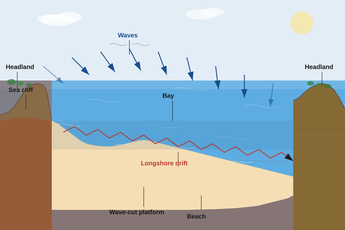
11. Fig. 5 shows a coastal landscape.
(a) What is a headland? [1 mark]
Answer: A headland is a narrow piece of land that projects out into the sea from the coastline. [1 mark]
Teaching Note: Headlands are usually made of harder, more resistant rock that erodes more slowly than the surrounding rock. This is why they stick out. Bays form between headlands where softer rock has been eroded away.
(b) Explain how a wave-cut platform is formed. [3 marks]
Answer: A wave-cut platform is formed through the following process:
- Wave erosion at the base of a cliff (through hydraulic action, abrasion, and solution) undercuts the cliff, forming a wave-cut notch. [1 mark]
- As the notch deepens, the rock above becomes unsupported and collapses due to gravity. [1 mark]
- Over time, the cliff retreats inland, leaving behind a flat, gently sloping wave-cut platform at the base, which is exposed at low tide. [1 mark]
Teaching Note: This is a classic example of how coastal erosion shapes landscapes. The key sequence is: erosion at cliff base → notch formation → cliff collapse → platform left behind. The platform is actually the former base of the cliff that has been worn flat by wave action.
Marking Scheme:
- 1 mark for wave-cut notch formation
- 1 mark for cliff collapse
- 1 mark for platform remaining after retreat
12. Describe the process of longshore drift and explain how it can lead to the formation of a spit. [4 marks]
Answer: Longshore drift process:
- Waves approach the coast at an angle due to prevailing wind direction. [1 mark]
- The swash (wave moving up the beach) carries sediment up the beach at this angle.
- The backwash (water flowing back down) flows perpendicular to the beach due to gravity.
- This zigzag movement transports sediment along the coast in the direction of the prevailing wind. [1 mark]
Spit formation: 5. When there is a change in coastline direction (e.g., at a river mouth or bay entrance), longshore drift continues to deposit sediment into open water. [1 mark] 6. Over time, this sediment builds up as a narrow ridge of sand or shingle called a spit, which projects out from the coast. [1 mark]
Teaching Note: Longshore drift is the most important process for moving sediment along coastlines. A spit forms where the coastline changes direction because the waves can no longer transport sediment along the same path — they deposit it instead. Spits often have a hooked end (recurved tip) due to changes in wind direction.
Marking Scheme:
- 1 mark for angled wave approach
- 1 mark for zigzag movement (swash/backwash)
- 1 mark for change in coastline direction
- 1 mark for deposition forming the spit
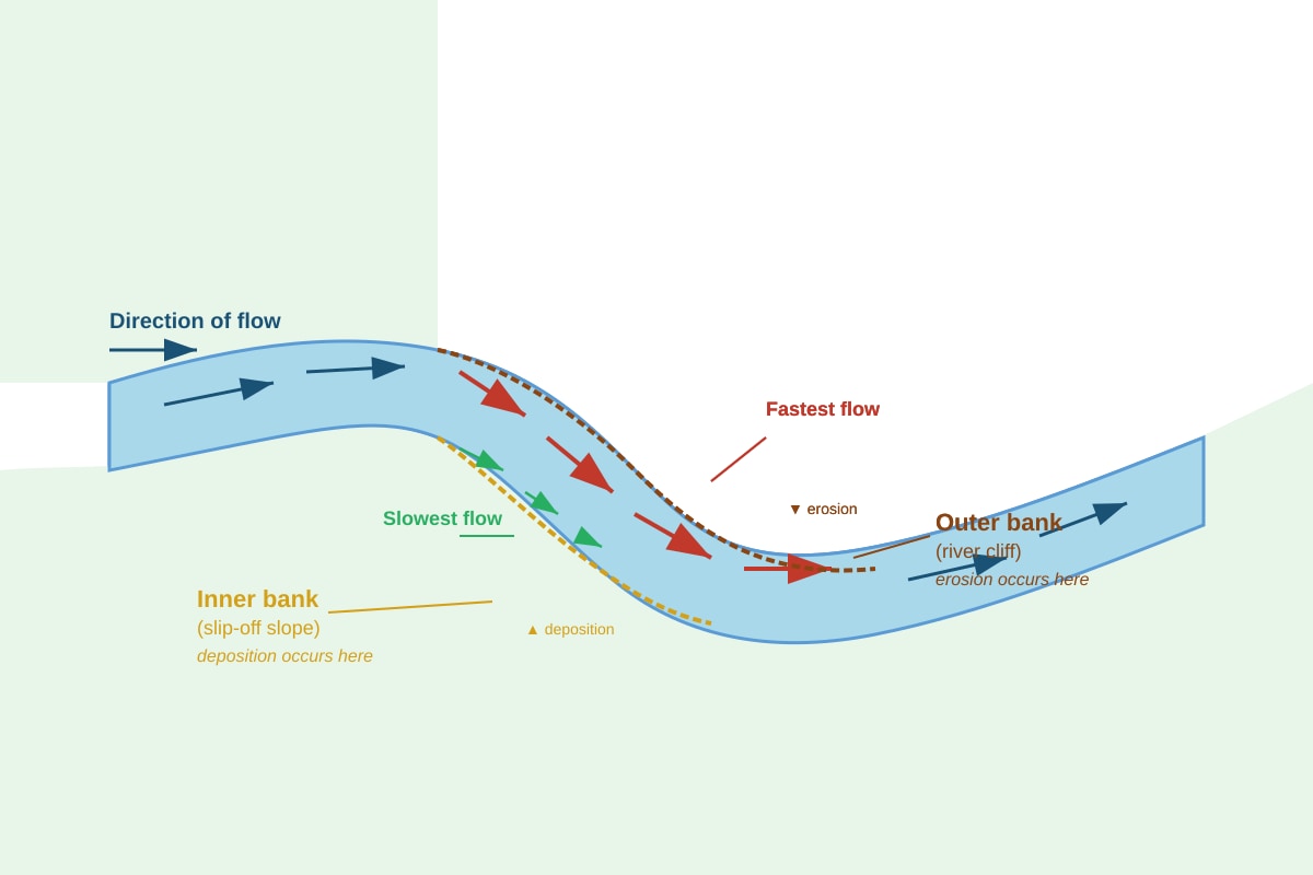
13. Fig. 6 shows a river meander.
(a) At which bank (outer or inner) does erosion mainly occur? [1 mark]
Answer: Erosion mainly occurs at the outer bank (river cliff). [1 mark]
Teaching Note: The water flows fastest on the outside of a bend because it has to travel further in the same time. Faster water has more energy to erode, so it cuts into the outer bank, creating a steep river cliff.
(b) Explain why deposition occurs on the inner bank of a meander. [2 marks]
Answer: Deposition occurs on the inner bank because the water flows more slowly there. [1 mark] The slower water has less energy to carry sediment, so it drops (deposits) the sediment it was carrying, building up a gentle slope called a slip-off slope (or point bar). [1 mark]
Teaching Note: This is a classic example of the relationship between water velocity and erosion/deposition. Fast water → erosion → deeper channel on outside. Slow water → deposition → shallower channel on inside. This process causes meanders to become more pronounced over time and eventually migrate across the floodplain.
Marking Scheme:
- 1 mark for identifying slower flow on inner bank
- 1 mark for explaining that slower water deposits sediment
14. State two ways in which rivers transport sediment. [2 marks]
Answer: (Any two of the following)
- Solution: Dissolved minerals carried in the water [1 mark]
- Suspension: Fine particles (silt, clay) carried within the water column [1 mark]
- Saltation: Small pebbles bouncing along the river bed [1 mark]
- Traction: Large boulders rolling or sliding along the river bed [1 mark]
Teaching Note: These are the four methods of fluvial transport, ordered from smallest to largest sediment size. The method depends on the river's energy (velocity) and the size of the sediment. Faster, more energetic rivers can transport larger sediment.
Common Mistake: Students sometimes list "erosion" or "deposition" as transport methods. These are different processes — transport is the movement of sediment, not its removal or dropping.
15. Explain how a waterfall is formed. [3 marks]
Answer: A waterfall forms where a river flows over an area with different rock types — a layer of hard rock (resistant to erosion) overlying a layer of soft rock (less resistant). [1 mark]
- The soft rock erodes more quickly through hydraulic action and abrasion, creating a plunge pool at the base. [1 mark]
- The hard rock above becomes undercut and eventually collapses into the plunge pool.
- The waterfall retreats upstream over time, leaving a steep-sided gorge downstream. [1 mark]
Teaching Note: The classic example is the Niagara Falls, where hard cap rock (dolomite) overlies softer shale. The process is self-reinforcing — as the waterfall retreats, it leaves a gorge, and the process continues. The key concept is differential erosion (different rock types eroding at different rates).
Marking Scheme:
- 1 mark for identifying the hard/soft rock layers
- 1 mark for explaining the undercutting and collapse process
- 1 mark for explaining retreat/gorge formation
Section D: Weather and Climate (Questions 16–20)
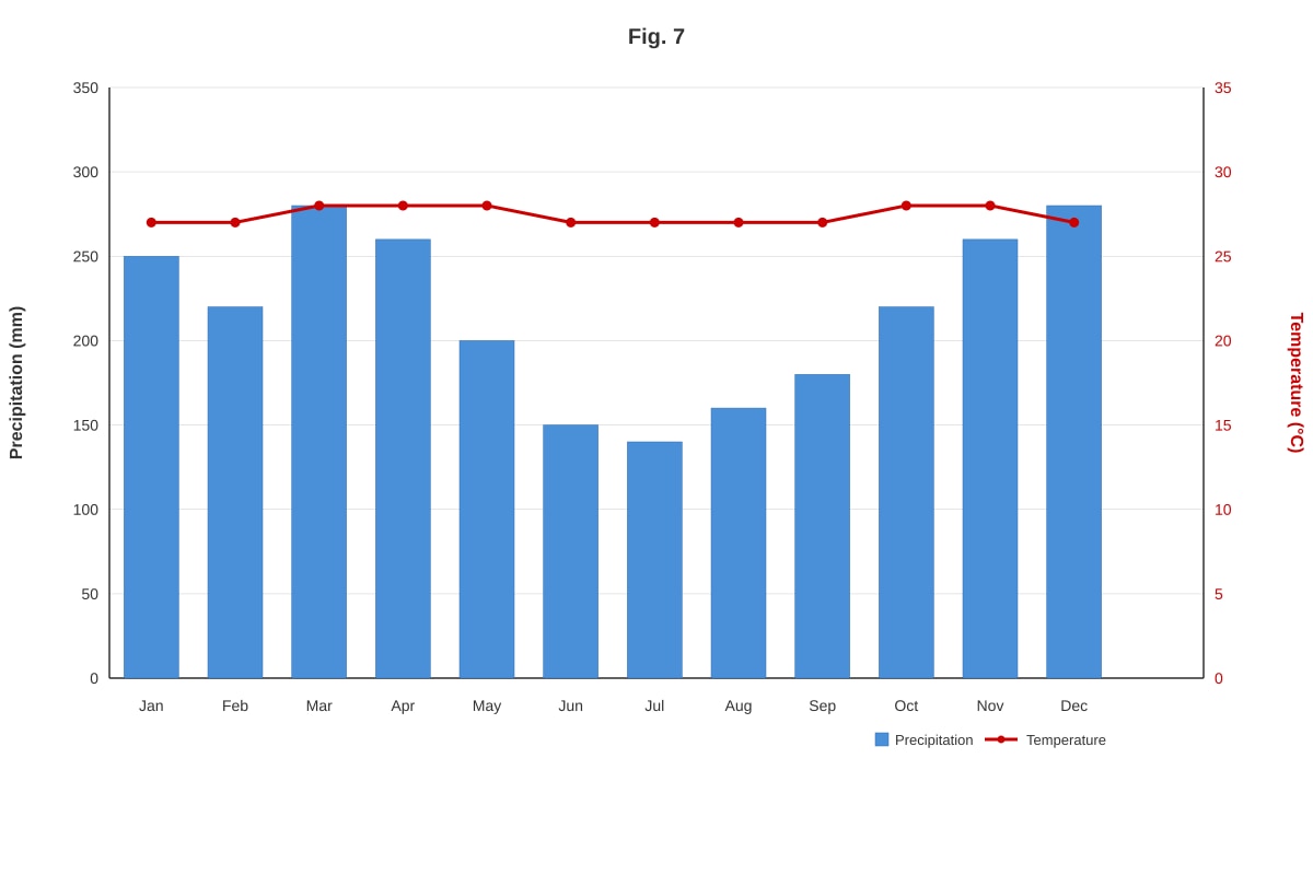
16. Fig. 7 shows the climate graph for a tropical location.
(a) Describe the temperature characteristics of this location. [2 marks]
Answer: The temperature is high all year round, with average monthly temperatures around 27-28°C. [1 mark] There is very little temperature variation between months (the annual temperature range is only about 1-2°C). [1 mark]
Teaching Note: This is a key characteristic of tropical climates — high temperatures with little seasonal variation. This is because the sun is always high in the sky near the equator, providing consistent solar energy throughout the year. The small variations are usually due to cloud cover and rainfall patterns.
Marking Scheme:
- 1 mark for stating high temperatures
- 1 mark for stating little variation/small range
(b) What type of climate does this location have? [1 mark]
Answer: Tropical rainforest climate (or Equatorial climate / Af climate in Koppen classification). [1 mark]
Teaching Note: The Koppen climate classification uses "Af" for tropical rainforest climates: A = tropical, f = no dry season (all months have at least 60 mm precipitation). The graph shows both high temperature and high rainfall all year, which is characteristic of this climate type.
17. Explain why the tropics receive more solar radiation than the polar regions. [3 marks]
Answer: The tropics receive more solar radiation because:
- Angle of the sun: The sun is directly overhead (or nearly so) at the equator, so solar energy is concentrated over a smaller area. [1 mark]
- Atmospheric path length: At the poles, sunlight travels through more atmosphere, so more energy is absorbed, scattered, or reflected before reaching the surface. [1 mark]
- Albedo effect: Polar regions have ice and snow which reflect more sunlight back into space, while tropical oceans and forests absorb more solar energy. [1 mark]
Teaching Note: This is the fundamental reason for global temperature differences. The same amount of solar energy is spread over a larger area at the poles (because of the Earth's curvature) and travels through more atmosphere. This creates the temperature gradient that drives global wind patterns and ocean currents.
Marking Scheme:
- 1 mark for angle of sun/concentration
- 1 mark for atmospheric path length
- 1 mark for albedo/reflection (or any other valid point)
18. What is the Intertropical Convergence Zone (ITCZ) and how does it affect rainfall in the tropics? [3 marks]
Answer: The ITCZ is a belt of low pressure near the equator where the trade winds from the Northern and Southern Hemispheres converge (meet). [1 mark]
- The intense solar heating at the equator causes warm, moist air to rise strongly. [1 mark]
- As the air rises, it cools and condenses, forming thick clouds and causing heavy rainfall — this is why the tropics are so wet. [1 mark]
Teaching Note: The ITCZ is not stationary — it moves north and south with the seasons, following the sun's apparent movement. This causes seasonal rainfall patterns in many tropical regions. For example, parts of Africa and India have wet and dry seasons depending on the ITCZ's position. The ITCZ is also associated with the formation of tropical cyclones.
Marking Scheme:
- 1 mark for defining ITCZ as a convergence zone/low pressure belt
- 1 mark for explaining rising warm air
- 1 mark for linking to condensation and rainfall
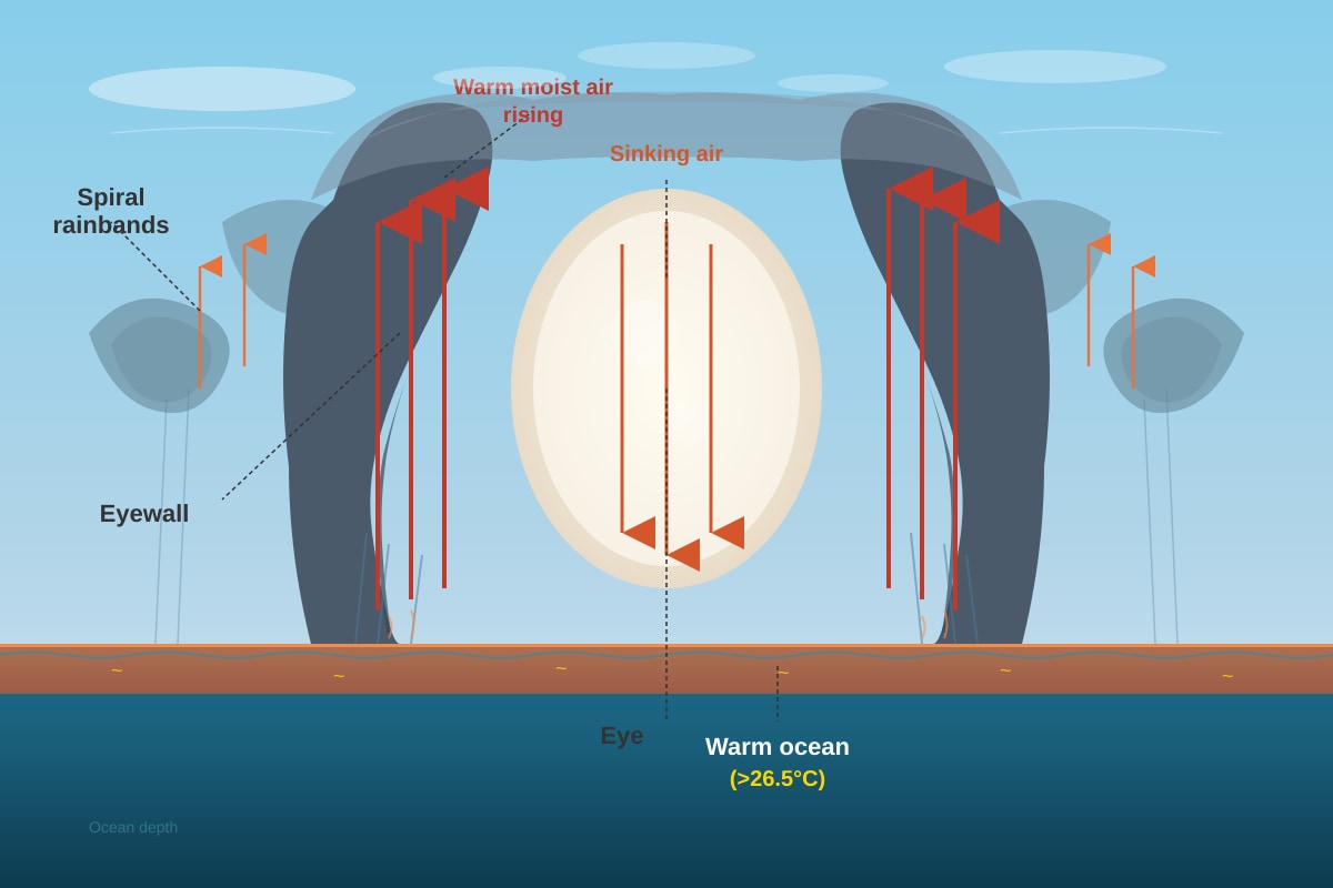
19. Fig. 8 shows the formation of a tropical cyclone.
(a) What is the "eye" of a tropical cyclone? [1 mark]
Answer: The eye is the calm, clear centre of the tropical cyclone, where air is sinking and skies are relatively clear. [1 mark]
Teaching Note: The eye is often the most recognisable feature of a tropical cyclone on satellite images. It is typically 30-65 km in diameter. The calm conditions in the eye are deceptive — the most violent weather is in the eyewall surrounding it.
(b) Explain why tropical cyclones form only over warm ocean waters. [2 marks]
Answer: Tropical cyclones need warm ocean water (at least 26.5°C) because:
- The warm water provides heat and moisture to the atmosphere through evaporation. [1 mark]
- This warm, moist air rises rapidly, releasing latent heat as it condenses, which powers the cyclone and causes air pressure to drop further, intensifying the storm. [1 mark]
Teaching Note: Tropical cyclones are essentially heat engines — they convert heat energy from warm ocean water into kinetic energy (wind). This is why they weaken rapidly when they move over land or cooler water — their energy source is cut off. They are called hurricanes in the Atlantic, typhoons in the Pacific, and cyclones in the Indian Ocean.
Marking Scheme:
- 1 mark for identifying warm water as energy/moisture source
- 1 mark for explaining the rising air/condensation/latent heat mechanism
20. Describe two impacts of climate change on physical geography. [4 marks]
Answer: (Any two of the following)
Impact 1: Sea level rise [1 mark] Explanation: Global warming causes thermal expansion of ocean water and melting of glaciers and ice sheets, leading to rising sea levels. This causes coastal erosion, flooding of low-lying areas, and salinisation of freshwater sources. [1 mark]
Impact 2: More extreme weather events [1 mark] Explanation: Climate change increases the frequency and intensity of extreme weather events like tropical cyclones, heatwaves, drougts, and heavy rainfall events. This leads to more flooding, landslides, and damage to ecosystems. [1 mark]
Impact 3: Melting of glaciers and ice caps [1 mark] Explanation: Rising temperatures cause glaciers and ice sheets (e.g., in Greenland, Antarctica, the Himalayas) to melt. This contributes to sea level rise and reduces freshwater supplies for millions of people who depend on glacial meltwater. [1 mark]
Impact 4: Changes in ecosystems [1 mark] Explanation: Warmer temperatures cause species to migrate towards the poles or to higher altitudes. Coral reefs experience bleaching when water temperatures rise. Some ecosystems may collapse if species cannot adapt or migrate fast enough. [1 mark]
Teaching Note: Climate change is already affecting physical geography around the world. The impacts are interconnected — for example, melting ice reduces albedo (reflection), which causes more warming, which causes more melting (a positive feedback loop). Students should understand that these are not future predictions but current observations.
Marking Scheme:
- 1 mark for each correctly identified impact (max 2)
- 1 mark for each clear explanation of the impact (max 2)
End of Answer Key