AI Generated Quiz
Secondary 2 Geography Human Geography Quiz
Free Sec 2 Geography Human Geography quiz, AI version, with questions, answers, and syllabus-aligned practice for Singapore students.
These static practice materials are generated from the site's syllabus and paper-generation workflow, with source and model context shown so students and parents can evaluate the material before use.
Questions
Free quiz and exam paper access
Enter your details to view this paper
Your access is remembered on this device.
Answers
Secondary 2 Geography Quiz - Human Geography (Answer Key)
Total Marks: 40
Section A: Urbanisation and City Growth (Questions 1–5)
1. Define the term "urbanisation." [2]
Answer: Urbanisation is the process by which an increasing proportion of a country's population lives in towns and cities. It involves the growth of urban areas as people move from rural to urban places.
Marking Notes:
- 1 mark for a basic definition (e.g., "people moving to cities").
- 1 mark for elaboration (e.g., "increasing proportion of population in urban areas" or "growth of towns and cities").
Teaching Note: Urbanisation is not just about cities getting bigger; it's about the shift in where people live. A country is said to be urbanising when more and more of its people live in urban areas compared to rural areas. This is usually measured as a percentage of the total population.
2. State two push factors that cause people to move from rural areas to cities. [2]
Answer: Any two of the following:
- Lack of job opportunities in rural areas (unemployment/underemployment)
- Low wages or income in farming
- Poor access to services such as healthcare and education
- Natural disasters or environmental degradation affecting farming
- Landlessness or lack of land ownership
- Crop failure due to drought, pests, or soil exhaustion
Marking Notes:
- 1 mark for each valid push factor (2 marks total).
- Accept any factor that "pushes" people away from rural areas.
Teaching Note: Push factors are negative conditions in a person's current location that encourage them to leave. They are different from pull factors, which are positive attractions of a new location. Common mistakes include giving pull factors (e.g., "better jobs in cities") instead of push factors.
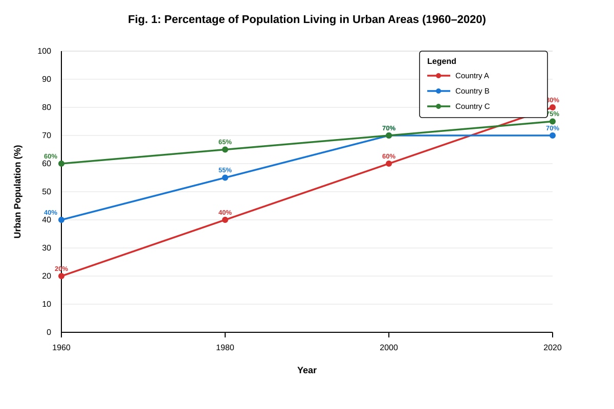
3. Study Fig. 1.
(a) Which country experienced the fastest rate of urbanisation between 1960 and 2020? Support your answer with data from Fig. 1. [2]
Answer: Country A experienced the fastest rate of urbanisation. Its urban population increased from 20% in 1960 to 80% in 2020, a total increase of 60 percentage points. This is a much faster increase compared to Country B (30 percentage points) and Country C (15 percentage points).
Marking Notes:
- 1 mark for identifying Country A.
- 1 mark for supporting with specific data (e.g., "from 20% to 80%" or "increase of 60 percentage points").
Teaching Note: Rate of urbanisation refers to how quickly the urban population is growing. To compare rates, look at the change over time, not just the final value. Country C started at 60% in 1960 (already highly urbanised) but only increased by 15 percentage points, so its rate was slower.
(b) Suggest one reason why Country B's urban population stopped increasing after 2000. [1]
Answer: Possible reasons:
- The country may have reached a saturation point where most people already live in cities (e.g., 70% urbanisation is already quite high).
- Rural-to-urban migration may have slowed because rural areas have also developed better services and job opportunities.
- The country may have implemented policies to slow urban growth or promote rural development.
Marking Notes:
- 1 mark for a reasonable suggestion.
- Accept any logical explanation.
Teaching Note: Urbanisation does not continue forever. Most developed countries have reached a plateau where the urban population stabilises at around 70–85%. This is because once most people already live in cities, the rate of further urbanisation naturally slows down.
4. Explain two problems that rapid urbanisation can cause in cities of developing countries. [4]
Answer: Any two of the following, with explanation:
Problem 1: Housing shortages and growth of squatter settlements Rapid urbanisation means many people move to cities faster than the city can build formal housing. This leads to the development of squatter settlements or slums, where people live in overcrowded, poorly built shelters without basic services like clean water, sanitation, or electricity.
Problem 2: Strain on infrastructure and services The rapid increase in population puts pressure on the city's infrastructure, such as roads, water supply, sewage systems, schools, and hospitals. This can lead to traffic congestion, water shortages, inadequate waste disposal, and long waiting times for healthcare and education.
Problem 3: Increased unemployment and underemployment When too many people move to a city, there may not be enough jobs for everyone. This leads to high unemployment or underemployment, where people work in low-paying, informal jobs with no job security or benefits.
Problem 4: Environmental degradation More people means more waste, more vehicles, and more demand for resources. This can lead to air and water pollution, deforestation on the city's outskirts, and increased greenhouse gas emissions.
Marking Notes:
- 1 mark for identifying each problem (2 marks).
- 1 mark for explaining each problem (2 marks).
- Award marks for clear, well-explained answers even if the specific problem named is different from the examples above.
Teaching Note: The key word here is "explain" – you need to do more than just name the problem. You must show how or why rapid urbanisation causes that problem. Use cause-and-effect language like "this leads to," "as a result," or "because."
5. Describe two ways in which a city can become more sustainable. [4]
Answer: Any two of the following, with description:
Way 1: Promoting public transport and active mobility A city can invest in efficient, affordable public transport systems such as trains, buses, and trams. It can also build cycling paths and pedestrian-friendly walkways. This reduces the number of private cars on the road, lowering air pollution and carbon emissions.
Way 2: Implementing green building designs New buildings can be designed with energy-efficient features such as solar panels, natural ventilation, rooftop gardens, and rainwater harvesting systems. This reduces the building's environmental impact and lowers energy and water consumption.
Way 3: Creating green spaces and parks A city can set aside land for parks, gardens, and nature reserves. These green spaces absorb carbon dioxide, reduce the urban heat island effect, provide habitats for wildlife, and offer recreational spaces for residents.
Way 4: Reducing, reusing, and recycling waste A city can implement comprehensive recycling programmes, encourage composting of food waste, and reduce the use of single-use plastics. This reduces the amount of waste sent to landfills and conserves natural resources.
Marking Notes:
- 1 mark for identifying each way (2 marks).
- 1 mark for describing each way with some detail (2 marks).
- Accept other valid sustainability strategies.
Teaching Note: Sustainability in cities means meeting the needs of current residents without compromising the ability of future generations to meet their own needs. It involves balancing environmental, social, and economic considerations. A simple description should explain what the strategy is and how it helps the city become more sustainable.
Section B: Housing and Settlements (Questions 6–10)
6. Distinguish between "formal housing" and "informal housing." [2]
Answer: Formal housing refers to legally built homes that are planned, approved by the government, and have proper infrastructure such as water, electricity, and sewage connections. Examples include HDB flats, condominiums, and landed properties.
Informal housing refers to homes built illegally or without official permission, often on land that the residents do not own. These settlements lack basic services and are usually built from cheap, makeshift materials. Squatter settlements are a type of informal housing.
Marking Notes:
- 1 mark for a correct definition or description of formal housing.
- 1 mark for a correct definition or description of informal housing.
- Accept answers that clearly contrast the two types.
Teaching Note: "Distinguish" means to show the difference between two things. A good answer will define both terms and highlight the key differences, such as legality, planning, access to services, and building materials.
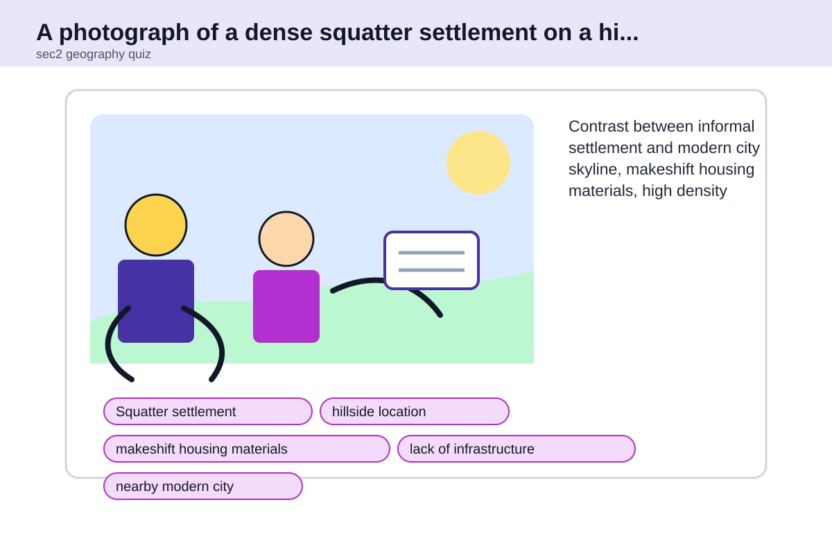
7. Study Fig. 2.
(a) Describe two characteristics of the squatter settlement shown in Fig. 2. [2]
Answer: Any two of the following:
- The houses are made of makeshift materials such as corrugated metal sheets, wood, and plastic sheeting.
- The houses are very densely packed together with little space between them.
- There are narrow, unpaved pathways instead of proper roads.
- There is no visible drainage system.
- The settlement is located on a hillside, which may be unsafe.
- The settlement is located near but separate from a modern city.
Marking Notes:
- 1 mark for each valid characteristic (2 marks total).
- Answers must be based on what is visible in the photograph description.
Teaching Note: "Describe" means to state what you can observe. Do not explain why the settlement exists or how it developed – just say what you see. Use specific details from the image.
(b) Explain one reason why squatter settlements often develop on the outskirts of large cities. [2]
Answer: Squatter settlements often develop on the outskirts of cities because land there is usually cheaper or less strictly controlled. Migrants who move to the city looking for work often cannot afford formal housing in the city centre. On the outskirts, they can occupy vacant land without paying rent, even though the land may be unsafe (e.g., flood-prone areas, steep slopes) or lack basic services.
Marking Notes:
- 1 mark for identifying a reason (e.g., "land is cheaper" or "less government control").
- 1 mark for explaining the reason (e.g., "migrants cannot afford city-centre housing").
- Accept other valid explanations.
Teaching Note: This is a cause-and-effect question. The reason is about why squatter settlements are located on the outskirts. Think about the needs of the people who live there (low income, need for affordable land) and the characteristics of the outskirts (cheaper land, less enforcement).
8. The Singapore government provides public housing through the Housing and Development Board (HDB). Explain two ways in which HDB towns are designed to promote community bonding. [4]
Answer: Any two of the following, with explanation:
Way 1: Common spaces and facilities HDB towns include void decks, community centres, playgrounds, and fitness corners. These shared spaces encourage residents to interact with their neighbours, organise community events, and build social ties. For example, void decks are used for weddings, funerals, and community gatherings.
Way 2: Racial and ethnic integration policies HDB uses an Ethnic Integration Policy (EIP) to ensure that each block and neighbourhood has a balanced mix of residents from different ethnic backgrounds. This prevents ethnic enclaves from forming and encourages interaction between people of different races, promoting racial harmony.
Way 3: Neighbourhood design with precincts HDB towns are divided into smaller precincts with shared gardens and play areas. This creates a sense of belonging and identity among residents of the same precinct. Residents are more likely to know their neighbours and look out for one another.
Way 4: Grassroots organisations and activities Each HDB town has grassroots organisations such as Residents' Committees (RCs) that organise activities like block parties, festive celebrations, and interest groups. These activities bring residents together and foster a sense of community.
Marking Notes:
- 1 mark for identifying each way (2 marks).
- 1 mark for explaining each way with specific detail (2 marks).
- Accept other valid ways that are specific to Singapore's HDB context.
Teaching Note: "Community bonding" means building relationships and a sense of belonging among residents. The question asks about design – how the physical layout and policies of HDB towns are intentionally planned to encourage interaction. Do not just describe HDB flats; explain the specific features that promote community.
9. Suggest two strategies that a city government could use to improve the lives of people living in squatter settlements. [4]
Answer: Any two of the following, with explanation:
Strategy 1: Slum upgrading programmes The government can provide basic services such as clean water, electricity, sewage systems, and paved roads to existing squatter settlements. This improves living conditions without forcing residents to move. The government can also help residents improve their homes by providing materials or loans.
Strategy 2: Relocation to formal housing The government can build low-cost public housing and relocate squatter settlement residents to these new homes. This provides them with secure tenure, proper infrastructure, and better living conditions. However, the new housing must be affordable and located near job opportunities.
Strategy 3: Providing land tenure and security The government can grant legal ownership or long-term leases to squatter residents for the land they occupy. This gives them security and encourages them to invest in improving their homes. It also allows the government to collect property taxes and regulate development.
Strategy 4: Creating job and skills training programmes The government can provide vocational training and job placement services to help squatter residents find stable employment. With better incomes, residents can afford formal housing and improve their quality of life.
Marking Notes:
- 1 mark for identifying each strategy (2 marks).
- 1 mark for explaining each strategy (2 marks).
- Accept other valid strategies.
Teaching Note: "Suggest" means to propose a possible solution. The strategies should be realistic and address the specific problems faced by squatter settlement residents, such as lack of basic services, insecure land tenure, and poverty. A good answer will explain how the strategy would improve their lives.
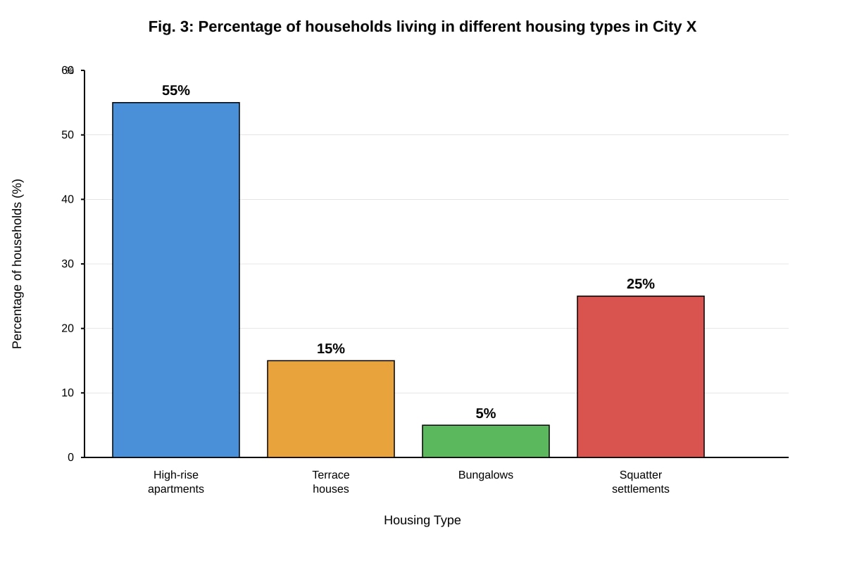
10. Study Fig. 3.
(a) What percentage of households in City X live in squatter settlements? [1]
Answer: 25%
Marking Notes:
- 1 mark for the correct answer.
- Accept "25%" or "25 percent."
Teaching Note: This is a direct data retrieval question. Read the bar chart carefully and find the bar labelled "Squatter settlements." The value at the top of the bar is the answer.
(b) Suggest one reason why high-rise apartments are the most common housing type in City X. [1]
Answer: Possible reasons:
- High-rise apartments can accommodate many people on a small area of land, which is important if land is scarce or expensive.
- The city government may have a policy of providing public housing in high-rise buildings.
- High-rise apartments are more cost-effective to build and maintain than low-rise housing for a large population.
Marking Notes:
- 1 mark for a reasonable suggestion.
- Accept any logical explanation.
Teaching Note: This question asks you to infer a reason from the data. Since 55% of households live in high-rise apartments, there must be a reason why this housing type is so dominant. Think about the advantages of high-rise living, especially in a city context where land is limited.
Section C: Transport and Urban Planning (Questions 11–15)
11. State two environmental problems caused by heavy traffic in cities. [2]
Answer: Any two of the following:
- Air pollution (from vehicle exhaust emissions)
- Noise pollution
- Increased carbon emissions contributing to climate change
- Urban heat island effect (heat from vehicles)
- Water pollution (from oil and fuel leaks washing into drains)
Marking Notes:
- 1 mark for each valid problem (2 marks total).
- Accept any clear environmental problem.
Teaching Note: "State" means to give a brief answer without explanation. Focus on the environmental impacts, not social or economic ones. Common mistakes include giving problems like "traffic jams" (which is a transport problem, not an environmental one) or "stress for drivers" (which is a health/social problem).
12. Explain how a "park and ride" system can help reduce traffic congestion in a city centre. [3]
Answer: A park and ride system works by providing large car parks on the outskirts of a city, near public transport stations (such as train or bus stops). Commuters drive from their homes to these car parks, park their cars for free or at a low cost, and then take public transport into the city centre. This reduces the number of cars entering the city centre, which eases traffic congestion. It also reduces the demand for parking spaces in the city centre.
Marking Notes:
- 1 mark for describing how the system works.
- 1 mark for explaining the link to reduced car numbers in the city centre.
- 1 mark for explaining the outcome (reduced congestion).
- Accept clear, logically sequenced explanations.
Teaching Note: "Explain" requires you to show the cause-and-effect relationship. Start by describing what a park and ride system is, then explain step by step how it leads to reduced congestion. Use connectives like "this means that," "as a result," and "therefore" to show the chain of reasoning.
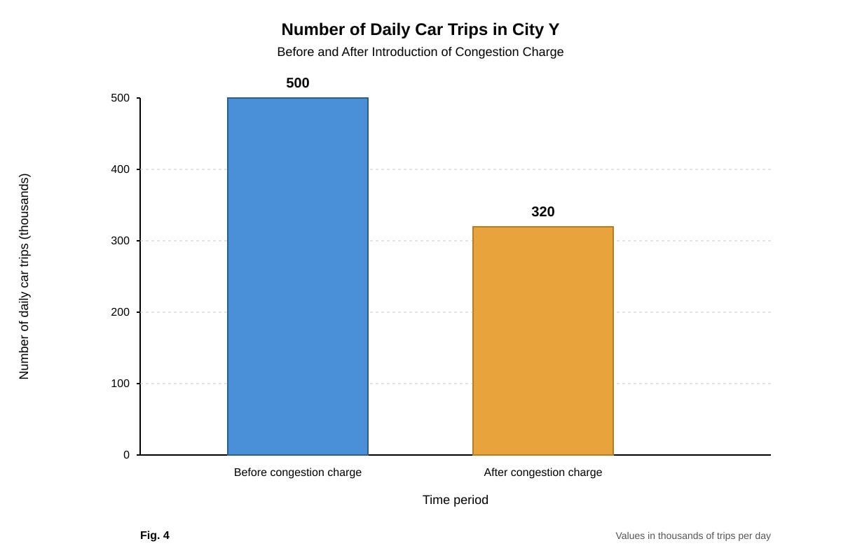
13. Study Fig. 4.
(a) Calculate the reduction in the number of daily car trips after the congestion charge was introduced. [1]
Answer: 500,000 - 320,000 = 180,000 trips
Marking Notes:
- 1 mark for the correct answer (180,000 or 180,000 trips).
- Accept the answer with or without the calculation shown.
Teaching Note: This is a simple subtraction. Read the values from the bar chart carefully. The "before" value is 500,000 and the "after" value is 320,000. The reduction is the difference.
(b) Explain one reason why a congestion charge might be unpopular with some residents. [2]
Answer: Possible reasons:
- It increases the cost of driving, which affects low-income residents who need their cars for work and cannot afford the charge.
- Some residents may not have good access to public transport alternatives, so they have no choice but to pay the charge.
- It may be seen as unfair if the charge is the same for everyone regardless of income.
- Businesses that rely on deliveries or customer access may lose income.
Marking Notes:
- 1 mark for identifying a reason.
- 1 mark for explaining the reason.
- Accept any valid reason with explanation.
Teaching Note: A congestion charge is a fee that drivers must pay to enter certain parts of a city during peak hours. While it can reduce traffic, it is often unpopular. Think about who is negatively affected and why they would oppose it.
14. Describe two features of a pedestrian-friendly city. [4]
Answer: Any two of the following, with description:
Feature 1: Wide, well-maintained pavements and walkways Pedestrian-friendly cities have pavements that are wide enough for people to walk comfortably, even during busy times. They are well-maintained, level, and free from obstacles. This makes walking safe and pleasant.
Feature 2: Pedestrian crossings and traffic-calming measures Safe and frequent pedestrian crossings, such as zebra crossings, traffic lights with pedestrian signals, and raised crossings, allow people to cross roads safely. Traffic-calming measures like speed bumps and narrower roads slow down vehicles, making streets safer for pedestrians.
Feature 3: Pedestrian-only zones or streets Some areas of the city are closed to vehicles entirely, creating car-free zones where people can walk, shop, and dine safely. These areas often have benches, trees, and street furniture that make them inviting places to spend time.
Feature 4: Good connectivity and mixed-use development Pedestrian-friendly cities are designed so that homes, shops, schools, and workplaces are located close together. This means people can walk to meet their daily needs instead of having to drive. Good connectivity means there are direct, safe walking routes between different places.
Marking Notes:
- 1 mark for identifying each feature (2 marks).
- 1 mark for describing each feature with some detail (2 marks).
- Accept other valid features.
Teaching Note: "Describe" means to give details about what the feature is and how it works. A pedestrian-friendly city prioritises people on foot over cars. Think about what makes walking safe, convenient, and enjoyable.
15. Suggest two ways in which improving public transport can make a city more sustainable. [4]
Answer: Any two of the following, with explanation:
Way 1: Reducing air pollution and carbon emissions When more people use public transport instead of private cars, there are fewer vehicles on the road. This reduces the emission of harmful pollutants such as carbon monoxide, nitrogen oxides, and particulate matter, as well as carbon dioxide, a greenhouse gas. This improves air quality and helps combat climate change.
Way 2: Reducing traffic congestion Efficient public transport can carry many more people than private cars using the same amount of road space. This reduces traffic congestion, which in turn reduces the time people spend idling in traffic and the fuel wasted. Less congestion also means less noise pollution.
Way 3: Conserving land and resources Public transport systems, especially trains, use less land per passenger than roads and car parks. This land can instead be used for parks, housing, or other productive purposes. Public transport also uses energy more efficiently per passenger than private cars.
Way 4: Promoting social equity Good public transport provides affordable mobility for everyone, including those who cannot afford a car. This allows all residents to access jobs, education, healthcare, and other services, contributing to social sustainability.
Marking Notes:
- 1 mark for identifying each way (2 marks).
- 1 mark for explaining each way with a clear link to sustainability (2 marks).
- Accept other valid ways.
Teaching Note: Sustainability has three pillars: environmental, social, and economic. A good answer will show how improved public transport contributes to one or more of these pillars. The explanation should clearly link the transport improvement to the sustainability outcome.
Section D: Population and Demographics (Questions 16–20)
16. Define the term "population density." [1]
Answer: Population density is the number of people living in a given area of land, usually measured as the number of people per square kilometre.
Marking Notes:
- 1 mark for a correct definition.
- Accept "number of people per unit area" or similar.
Teaching Note: Population density is a measure of how crowded a place is. It is calculated by dividing the total population by the total land area. A high population density means many people live in a small area (like Singapore), while a low population density means few people live in a large area (like Mongolia).
17. State two factors that influence the distribution of population in a country. [2]
Answer: Any two of the following:
- Climate (people prefer areas with moderate, habitable climates)
- Relief/terrain (flat, low-lying areas are easier to build on and farm)
- Availability of water (areas with reliable water sources can support more people)
- Soil fertility (fertile soil supports agriculture and thus larger populations)
- Natural resources (areas with minerals, oil, or other resources attract workers)
- Economic opportunities (cities and industrial areas attract migrants)
- Government policies (some governments encourage or restrict settlement in certain areas)
Marking Notes:
- 1 mark for each valid factor (2 marks total).
- Accept any factor that clearly influences where people choose to live.
Teaching Note: Population distribution refers to where people live within a country. Factors can be physical (like climate and relief) or human (like economic opportunities and government policies). A common mistake is to give factors that affect population growth (like birth rate) instead of distribution.
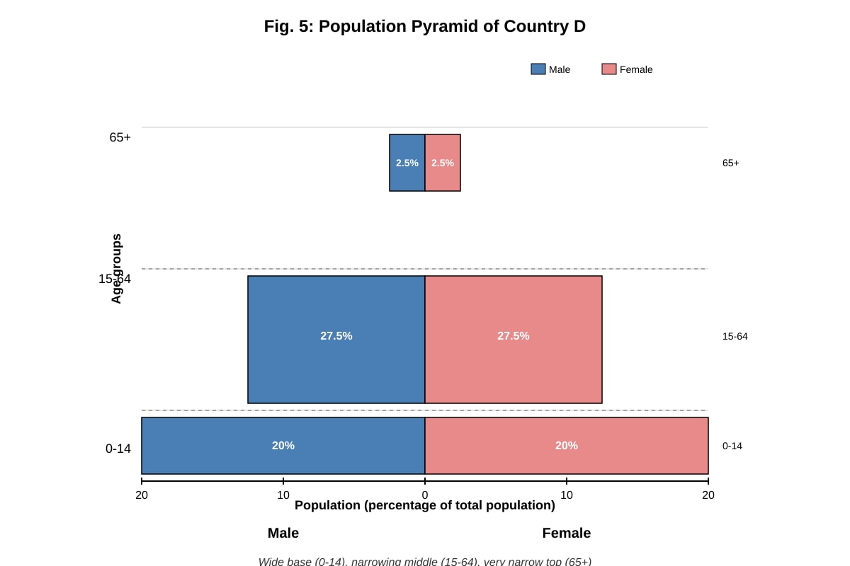
18. Study Fig. 5.
(a) Describe the shape of Country D's population pyramid. [1]
Answer: The pyramid has a wide base and narrows quickly towards the top. This indicates a high proportion of young people and a small proportion of elderly people.
Marking Notes:
- 1 mark for a correct description of the shape.
- Accept "pyramid-shaped," "wide base and narrow top," or "triangular shape."
Teaching Note: A population pyramid with a wide base and narrow top is typical of a country with high birth rates and high death rates (often a developing country). The shape tells you about the age structure of the population.
(b) Suggest one economic challenge that Country D might face because of its population structure. [2]
Answer: Possible challenges:
- High dependency ratio: There are many young people (under 15) who depend on a relatively smaller working-age population for support. This means the government must spend a large amount on schools, healthcare, and other services for children, while the tax base from workers is limited.
- Future unemployment: When the large number of young people enter the workforce, there may not be enough jobs for them, leading to high unemployment.
- Pressure on education system: The large number of children means the government must build many schools and train many teachers, which is expensive.
Marking Notes:
- 1 mark for identifying a challenge.
- 1 mark for explaining the challenge.
- Accept any valid economic challenge linked to the pyramid shape.
Teaching Note: The wide base means a large youth population. Think about the economic implications of having many children relative to the number of working-age adults. The key concept here is the "dependency ratio" – the ratio of dependents (young and old) to the working-age population.
19. Explain two reasons why some countries have an ageing population. [4]
Answer: Any two of the following, with explanation:
Reason 1: Declining birth rates When birth rates fall, fewer babies are born each year. Over time, this means that the proportion of young people in the population decreases, while the proportion of elderly people increases. This is common in developed countries where families choose to have fewer children due to the high cost of raising children, more women in the workforce, and better access to family planning.
Reason 2: Increasing life expectancy Advances in healthcare, nutrition, and sanitation mean that people are living longer than before. When more people survive into old age, the proportion of elderly people in the population increases. This is especially true in developed countries with good healthcare systems.
Reason 3: The baby boomer generation reaching old age In some countries, a large generation born after World War II (the "baby boomers") is now reaching retirement age. This large cohort moving into the elderly age group increases the proportion of elderly people in the population.
Marking Notes:
- 1 mark for identifying each reason (2 marks).
- 1 mark for explaining each reason (2 marks).
- Accept other valid reasons.
Teaching Note: An ageing population means that the median age of the population is increasing and the proportion of elderly people (usually 65+) is growing. This is caused by two main factors: people living longer (increased life expectancy) and fewer babies being born (declining fertility). Both factors work together to shift the age structure.
20. Suggest two strategies that a government could use to address a declining birth rate. [4]
Answer: Any two of the following, with explanation:
Strategy 1: Providing financial incentives for having children The government can offer cash bonuses, tax breaks, or baby bonuses to families who have children. It can also provide subsidised childcare, paid parental leave, and housing grants for families. These measures reduce the financial burden of raising children and encourage couples to have more children.
Strategy 2: Improving work-life balance policies The government can introduce policies that make it easier for parents to balance work and family life. This includes flexible working hours, part-time work options, and extended parental leave for both mothers and fathers. When parents do not have to choose between their careers and having children, they may be more willing to have larger families.
Strategy 3: Promoting immigration of young families The government can encourage immigration of young, working-age people and their families. Immigrants can help increase the birth rate and also boost the working-age population. This is a faster way to address population decline than waiting for birth rates to rise.
Strategy 4: Improving access to fertility treatments and childcare The government can subsidise fertility treatments for couples who have difficulty conceiving. It can also increase the availability and affordability of childcare services, making it easier for parents to return to work after having children.
Marking Notes:
- 1 mark for identifying each strategy (2 marks).
- 1 mark for explaining each strategy (2 marks).
- Accept other valid strategies.
Teaching Note: A declining birth rate means that the country's population is not replacing itself. Governments that want to increase the birth rate need to address the reasons why people are choosing to have fewer children. Common reasons include the high cost of raising children, difficulty balancing work and family, and lack of affordable childcare. Strategies should target these barriers.
--- END OF ANSWER KEY ---