From Real Exams Quiz
Secondary 2 Geography Physical Geography Quiz
Free Sec 2 Geography Physical Geography quiz, HY3 Exam version, with questions, answers, and syllabus-aligned practice for Singapore students.
These static practice materials are generated from the site's syllabus and paper-generation workflow, with source and model context shown so students and parents can evaluate the material before use.
Questions
Free quiz and exam paper access
Enter your details to view this paper
Your access is remembered on this device.
Answers
Secondary 2 Geography Quiz - Physical Geography (Answer Key)
Total Marks: 40
Topic: Physical Geography
Section A: Map & Data Skills
Q1. (1 mark)
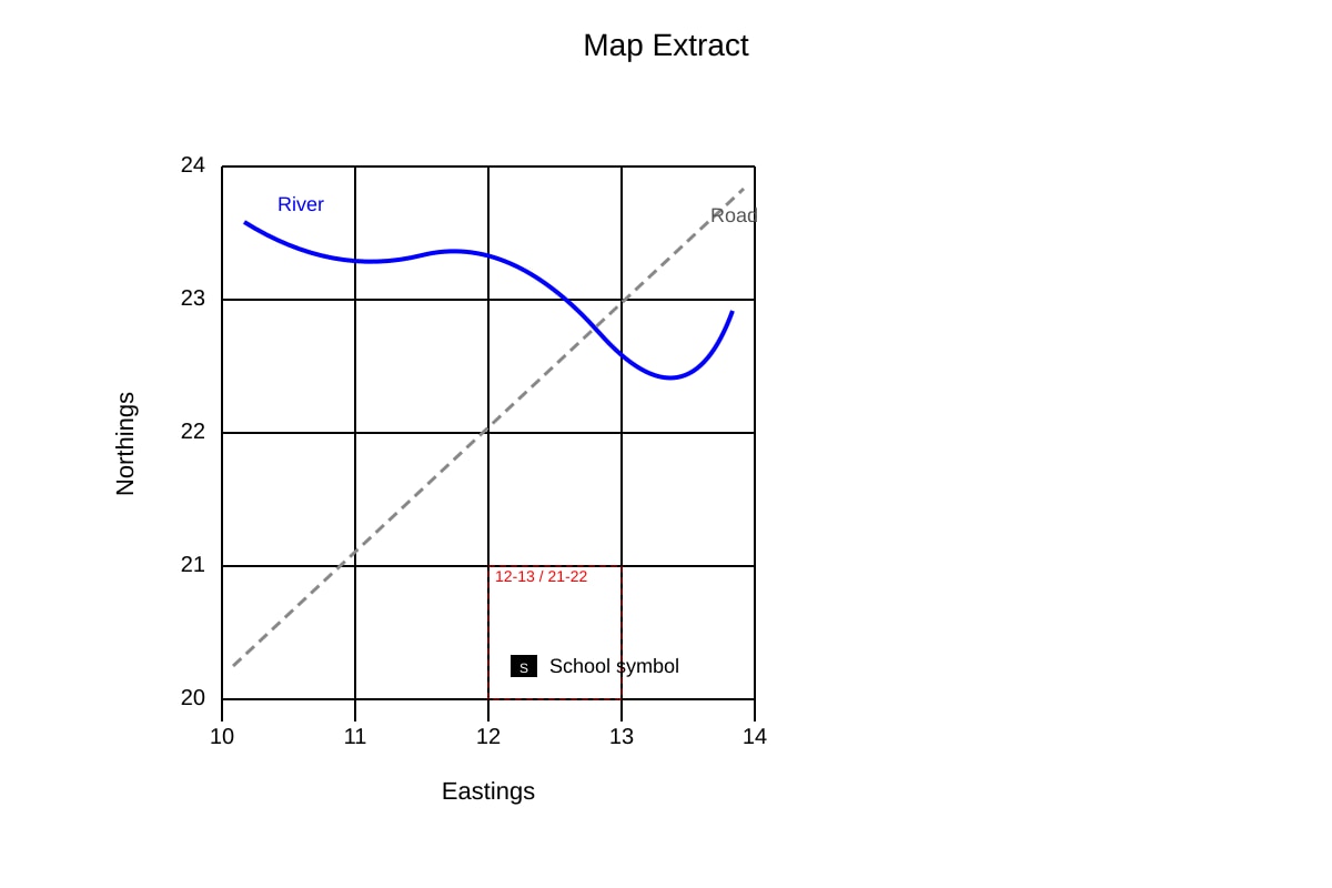
Answer: 1221
Teaching note: Four-figure grid reference uses easting first (vertical grid line to the left of feature = 12) then northing (horizontal grid line below feature = 21). Common mistake: writing northing first (2112). From placeholder, school is in square 12–13 E, 21–22 N, near lower-left → 1221.
Q2. (2 marks)
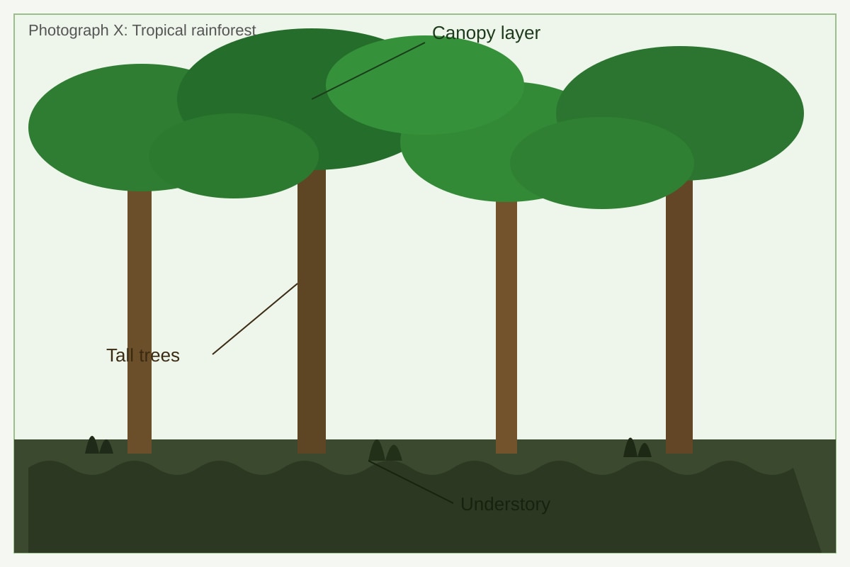
(a) Characteristic: Dense green canopy / tall trees (1 mark)
(b) Explanation: The canopy captures sunlight for photosynthesis and creates shade that reduces water loss; tall trees reach sunlight above competitors, supporting plant growth. (1 mark)
Marking: 1 for observation, 1 for link to plant life.
Q3. (3 marks)
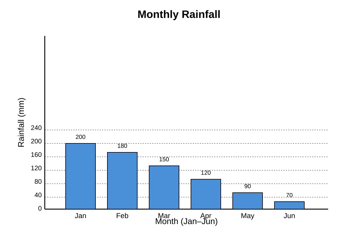
Answer: Rainfall decreased steadily from 200 mm in January to 70 mm in June. It fell by 130 mm over the period, with the sharpest drop between Jan–Mar (50 mm drop) and a gradual decline after. (3 marks: 1 overall trend, 1 specific stats, 1 rate/description)
Teaching: Use graph values; describe journey not just ends.
Q4. (1 mark)
Answer: 134227
Method: Six-figure = easting 13 + 4 tenths = 134; northing 22 + 7 tenths = 227. Common error: swapping order.
Q5. (2 marks)
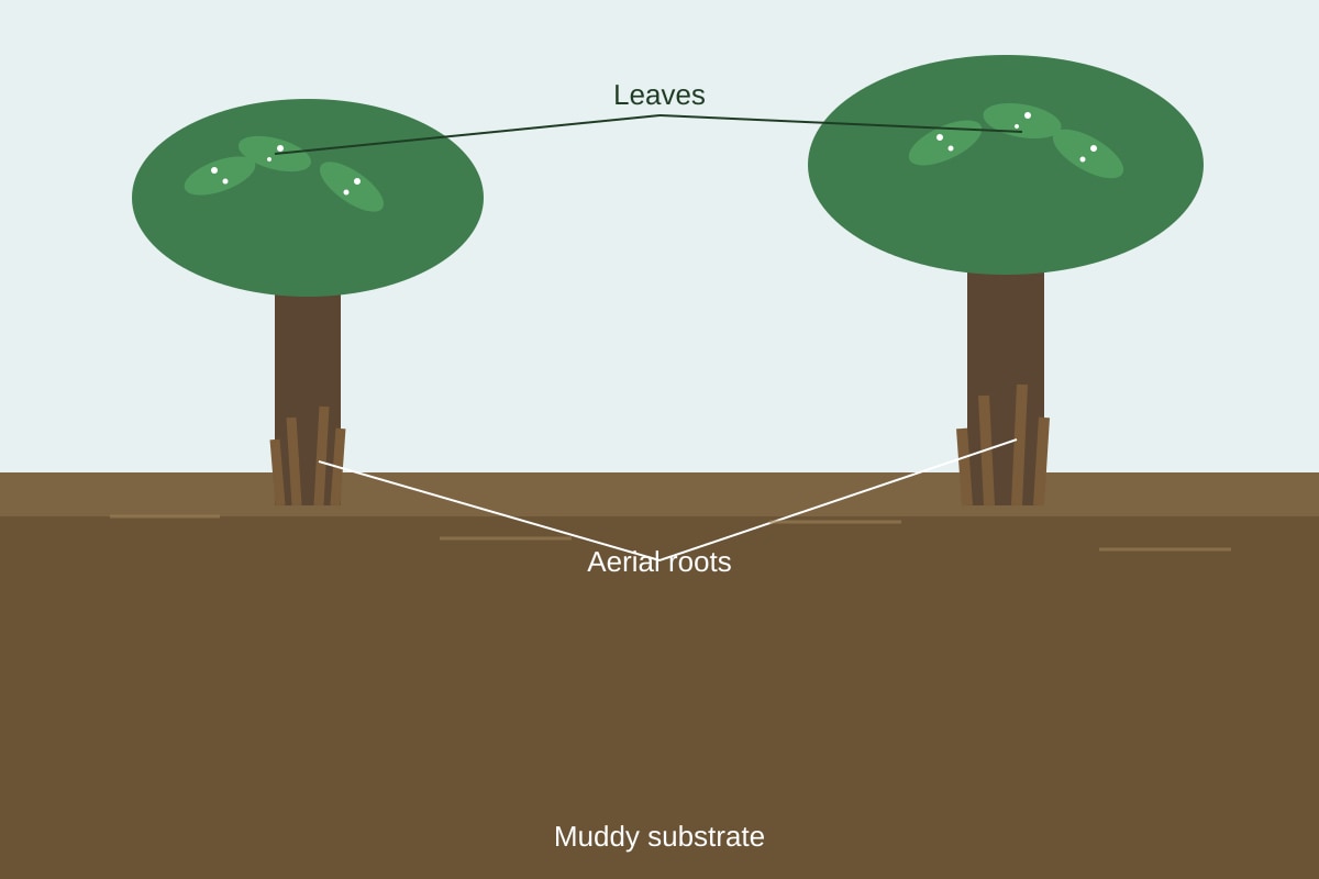
(a) Adaptation: Aerial roots / salt-secreting leaves (1 mark)
(b) Purpose: Aerial roots take in oxygen from air in waterlogged soil; salt secretion removes excess salt. (1 mark)
Section B: Water & Hydrological Cycle
Q6. (1 mark)
Answer: Solid (ice), Liquid (water), Gas (water vapour).
Note: Any order acceptable.
Q7. (1 mark)
Answer: Oceans > Glaciers > Rivers.
Teaching: Oceans hold ~97% of water, glaciers are largest freshwater store, rivers are tiny.
Q8. (2 marks)
Answer: Water budget is the balance between water inputs (e.g., rainfall) and outputs (e.g., evaporation, runoff) in a catchment. (2 marks: 1 definition, 1 cycle link)
Q9. (3 marks)
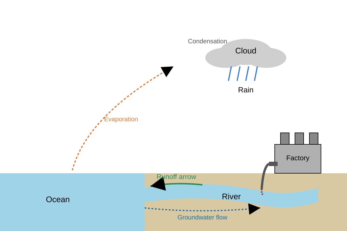
Answer: Factory discharges waste into river (1). Rainfall and runoff carry pollutants from land into river (1). This contaminates water, harming aquatic life and human supply (1).
Marking descriptors: mechanism (1), pathway (1), impact (1).
Q10. (2 marks)
Answer: Any two of: local catchment water, imported water, NEWater, desalination. (1 mark each)
Section C: Tropical Rainforests & Mangroves
Q11. (1 mark)
Answer: Emergent layer, Canopy, Understory/Undergrowth. (all three for mark)
Q12. (2 marks)
Answer: Rainforests store carbon in trees (1), reducing CO₂ in atmosphere and slowing climate change (1).
Q13. (3 marks)
Answer: Mangroves need warm tropical temperatures (1), saline coastal waters (1), and sheltered muddy shores where their adaptations (aerial roots) work (1).
Q14. (3 marks)
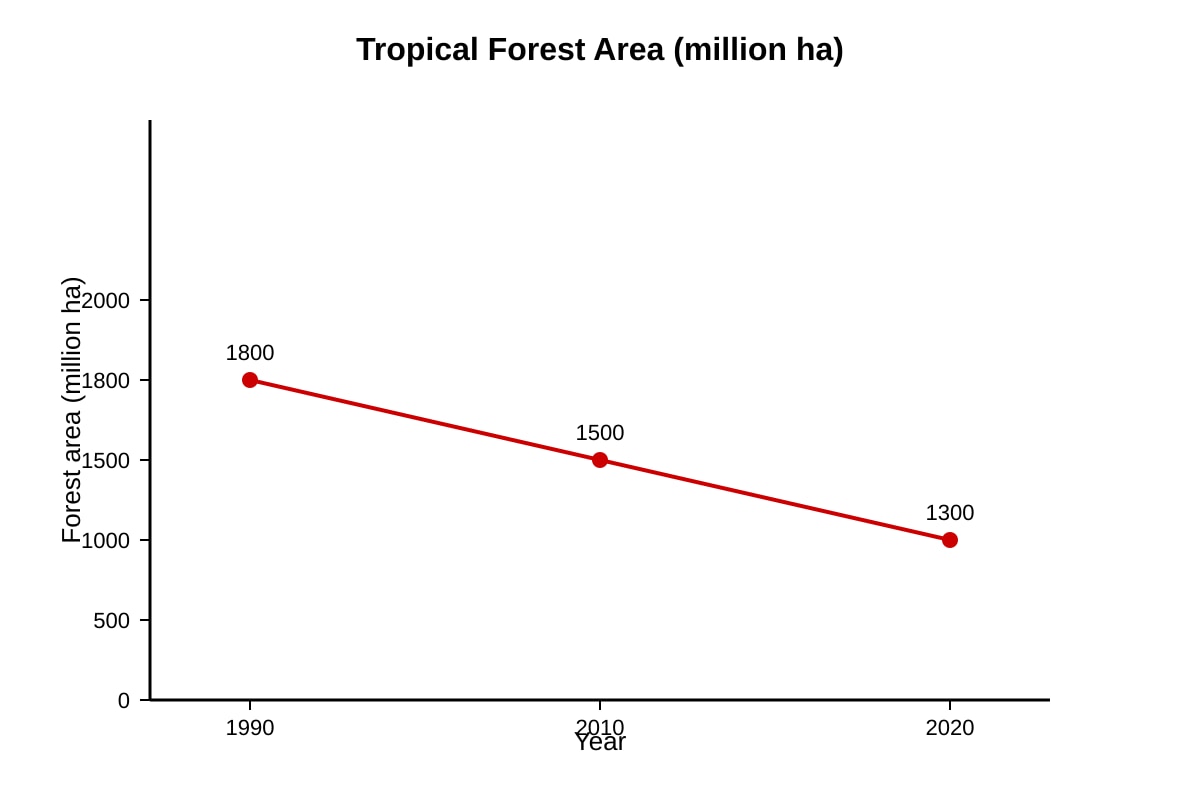
Answer: Forest area fell from 1800 to 1300 million ha (1). Human cause: logging or agriculture cleared land (1) leading to loss (1).
Q15. (2 marks)
Answer: Strategy: Protected reserves (e.g., Sungei Buloh). Reason: limits clearing and conserves habitat (2 marks: 1 strategy, 1 eval).
Section D: Structured Application
Q16. (2 marks)
Answer: Partly agree (1). Reason: desalination needs energy and is costly; rain-independent but not perfect (1).
Q17. (3 marks)
Answer: Trees store carbon (1). Cutting releases CO₂ (1). Extra CO₂ traps heat, enhancing greenhouse effect (1).
Q18. (2 marks)
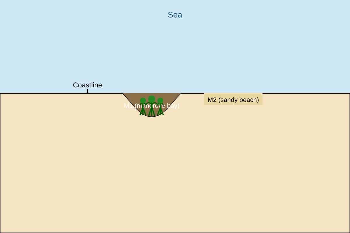
(a) M1 (1)
(b) M1 has mangroves, so biodiversity study possible; M2 is bare beach (1).
Q19. (2 marks)
Answer: Aerial roots protrude above mud to absorb oxygen (1) since waterlogged soil lacks air (1).
Q20. (2 marks)
Method: Industrial % = (500 / 1200) × 100 = 41.67% ≈ 41.7% (2 marks: 1 formula, 1 answer).
Teaching: Always divide part by total × 100.