From Real Exams Quiz
Secondary 2 Geography Human Geography Quiz
Free Sec 2 Geography Human Geography quiz, Exam version, with questions, answers, and syllabus-aligned practice for Singapore students.
These static practice materials are generated from the site's syllabus and paper-generation workflow, with source and model context shown so students and parents can evaluate the material before use.
Questions

Free quiz and exam paper access
Enter your details to view this paper
Your access is remembered on this device.
Answers
Secondary 2 Geography Quiz - Human Geography: Answer Key
Total Marks: 40
Section A: Urbanisation and Population (Questions 1–5)
Question 1 [1 mark]
Answer: Urbanisation is the process by which an increasing percentage of a country's population comes to live in towns and cities.
Marking notes:
- Award 1 mark for a clear definition that mentions the movement/increase of population living in urban areas.
- Do not accept simply "people moving to cities" without reference to the process or increasing proportion.
Teaching note: Urbanisation is a key concept in human geography. It refers not just to people moving to cities, but to the overall shift in population distribution from rural to urban areas. This process has accelerated dramatically since the Industrial Revolution and is now a global phenomenon, especially in developing countries.
Question 2 [3 marks]
(a) [2 marks]
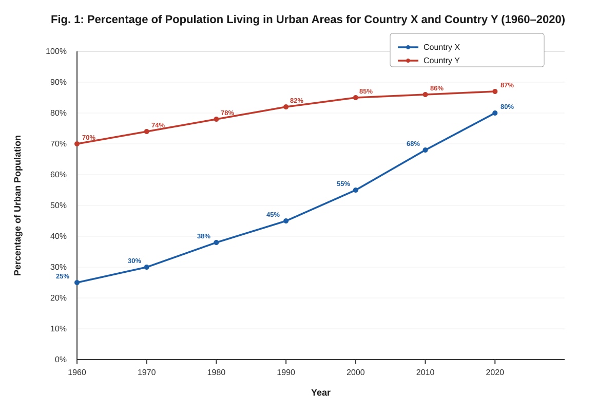
Answer: The percentage of urban population in Country X increased steadily from 25% in 1960 to 55% in 2000, then rose more steeply to 80% in 2020. This shows a rapid acceleration in urbanisation after 2000.
Marking notes:
- Award 1 mark for describing the overall trend (increase/rise).
- Award 1 mark for using specific data points from the graph (e.g., 25% in 1960, 80% in 2020).
- Accept mention of the steeper increase after 2000 as a valid observation.
Common mistake: Students may only state the start and end values without describing the pattern of change (e.g., steady then steep increase).
(b) [1 mark]
Answer: Country Y was already highly urbanised in 1960 because it was already an industrialised/developed country with most of its population living in cities for jobs and services.
Marking notes:
- Award 1 mark for any reasonable suggestion, such as: early industrialisation, already a developed economy, limited rural land, historical urban settlement patterns.
- Accept: "Country Y was already a developed country with many industries in cities."
Teaching note: Countries that industrialised early (like the UK, USA, Japan) had already undergone their urban transition by 1960. In contrast, many developing countries (like Country X) began rapid urbanisation later, often after 1950.
Question 3 [2 marks]
Answer: Two push factors that cause people to move from rural areas to cities:
- Lack of employment opportunities – Rural areas often have limited jobs, especially in agriculture, forcing people to seek work in cities.
- Poor access to services – Rural areas may lack schools, hospitals, and other basic services, encouraging people to move to cities where these are available.
Marking notes:
- Award 1 mark for each correctly identified and explained push factor (2 marks total).
- Accept other valid push factors: low wages, natural disasters, landlessness, crop failure, lack of infrastructure, conflict/insecurity.
- Do not accept pull factors (attractions of the city) – the question specifically asks for push factors.
Teaching note: Push factors are negative conditions in a person's current location that encourage them to leave. Pull factors are positive attractions of a new location. Students often confuse these, so it is important to emphasise the distinction.
Question 4 [4 marks]
(a) [2 marks]
Answer: Two characteristics of the squatter settlement:
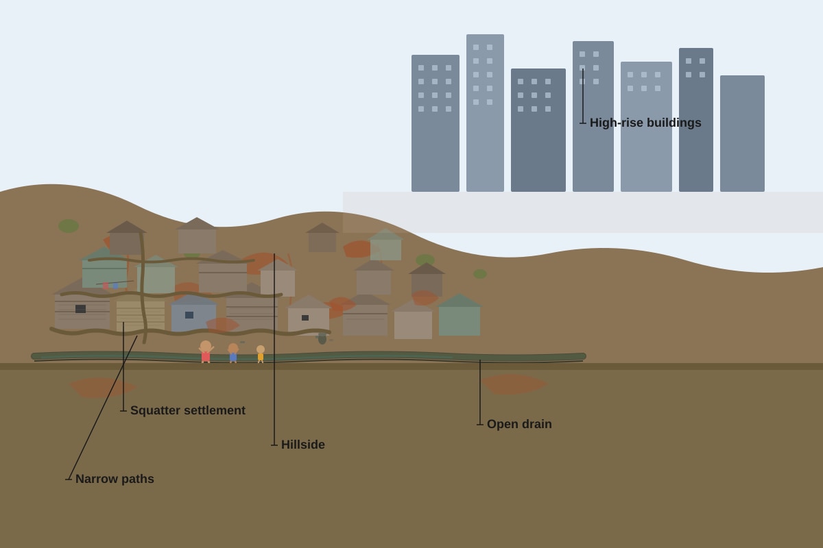
- The houses are made from temporary or scavenged materials such as corrugated metal sheets, wooden planks, and plastic sheeting.
- The houses are densely packed together with narrow dirt paths between them, showing high population density and lack of proper planning.
Marking notes:
- Award 1 mark for each valid characteristic clearly described (2 marks total).
- Accept other valid observations: houses built on a hillside, lack of proper roads, open drains visible, close to city centre but separate from formal housing.
- Answers must be based on what is visible in the photograph.
(b) [2 marks]
Answer: One environmental problem is water pollution. The photograph shows an open drain, which suggests that the settlement lacks proper sewage systems. Waste and sewage may flow into nearby rivers or groundwater, contaminating water sources and harming both human health and aquatic ecosystems.
Marking notes:
- Award 1 mark for identifying a valid environmental problem.
- Award 1 mark for explaining how it results from the squatter settlement conditions.
- Accept other valid problems: soil erosion (from hillside clearing), air pollution (from burning waste), deforestation (for building materials), landslides (from unstable hillside construction).
Teaching note: Squatter settlements (also called informal settlements or shantytowns) often lack basic infrastructure such as piped water, sewage systems, and waste collection. This leads to significant environmental degradation and health risks for residents.
Question 5 [3 marks]
Answer: Slum upgrading improves the lives of people living in squatter settlements by:
- Providing basic services – Installing piped water, sewage systems, and electricity improves health and quality of life.
- Improving housing – Replacing temporary structures with more permanent, safer housing reduces risks from fires, storms, and landslides.
- Providing legal land tenure – Giving residents legal ownership or rights to their land allows them to invest in their homes and access formal services like loans and insurance.
Marking notes:
- Award 1 mark for each valid point with explanation (up to 3 marks).
- Accept other valid points: improved access to schools and healthcare, creation of community spaces, better roads and transport links.
- Answers must explain how the strategy improves lives, not just name the strategy.
Teaching note: Slum upgrading is different from slum clearance. Upgrading improves existing settlements rather than demolishing them, which is often less disruptive and more affordable. It is considered a more sustainable approach to improving informal housing.
Section B: Housing and Transport (Questions 6–10)
Question 6 [2 marks]
Answer: Two types of formal housing commonly found in cities:
- HDB flats / public housing – High-rise apartment blocks built by the government.
- Landed property – Including bungalows, semi-detached houses, and terrace houses.
Marking notes:
- Award 1 mark for each correctly identified type (2 marks total).
- Accept other valid types: condominiums, apartments, private flats, townhouses.
- Do not accept informal housing types (squatter settlements, slums).
Teaching note: Formal housing refers to housing that is legally built, planned, and regulated by authorities. It typically has proper infrastructure, legal ownership, and meets building safety standards. This contrasts with informal housing, which develops outside official planning systems.
Question 7 [3 marks]
(a) [2 marks]
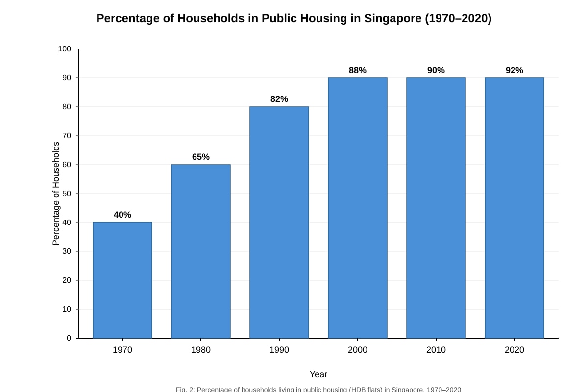
Answer: The percentage of households living in public housing in Singapore increased significantly from 40% in 1970 to 92% in 2020. The most rapid increase occurred between 1970 and 1990, when it rose from 40% to 82%. After 1990, the increase slowed, reaching 92% by 2020.
Marking notes:
- Award 1 mark for describing the overall trend (increase).
- Award 1 mark for using specific data points (e.g., 40% in 1970, 92% in 2020, or the 1970-1990 increase).
- Accept mention of the slowing rate of increase after 1990.
(b) [1 mark]
Answer: The rapid increase between 1970 and 1990 was due to the government's active public housing programme, which built large numbers of HDB flats to house the growing population.
Marking notes:
- Award 1 mark for any reasonable suggestion, such as: government housing programmes, HDB building projects, relocation from kampongs to flats, population growth requiring more housing.
- Accept: "The government built many new towns like Toa Payoh and Ang Mo Kio during this period."
Teaching note: Singapore's public housing programme is one of the most successful in the world. The Housing and Development Board (HDB) was established in 1960, and by the 1970s-1980s, large-scale building of new towns transformed Singapore's housing landscape. Today, over 80% of Singaporeans live in HDB flats.
Question 8 [4 marks]
Answer: Two ways HDB towns promote sustainable living:
- Integrated transport planning – HDB towns are built near MRT stations and bus interchanges, reducing the need for private cars and lowering carbon emissions.
- Provision of green spaces – HDB estates include parks, gardens, and green corridors that improve air quality, reduce the urban heat island effect, and provide recreational spaces.
Marking notes:
- Award 2 marks for each well-explained point (4 marks total).
- For each point: 1 mark for identifying the feature, 1 mark for explaining how it promotes sustainability.
- Accept other valid points: energy-efficient building design, water-saving features, recycling facilities, community gardens, mixed-use developments (shops and services within walking distance).
Teaching note: Sustainable living means meeting current needs without compromising the ability of future generations to meet their own needs. In housing, this involves environmental (reducing resource use), social (creating liveable communities), and economic (affordable housing) dimensions.
Question 9 [3 marks]
(a) [1 mark]
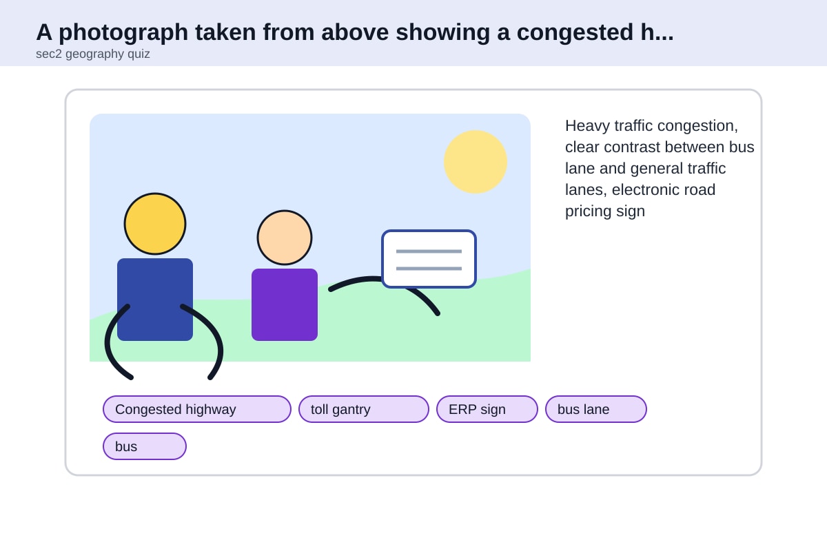
Answer: Electronic Road Pricing (ERP) / congestion pricing.
Marking notes:
- Award 1 mark for identifying ERP or congestion pricing.
- Accept: "toll gantry" or "road pricing."
- Do not accept "bus lane" – the bus lane is a separate strategy.
(b) [2 marks]
Answer: ERP reduces traffic congestion by charging drivers a fee to use congested roads during peak hours. This encourages drivers to either travel at different times, use alternative routes, or switch to public transport. As a result, the number of vehicles on the road during peak hours decreases, reducing congestion.
Marking notes:
- Award 1 mark for explaining the mechanism (charging drivers during peak hours).
- Award 1 mark for explaining the outcome (fewer cars, reduced congestion).
- Accept reference to behavioural change: "drivers choose to carpool, take public transport, or travel at off-peak times."
Teaching note: ERP is a form of demand management – it does not increase road capacity but instead manages the demand for road use. Singapore was the first city in the world to implement a comprehensive electronic road pricing system in 1998.
Question 10 [1 mark]
Answer: One disadvantage of ERP:
- It can be expensive for low-income drivers who have no alternative but to drive during peak hours.
- It may simply shift congestion to non-priced roads or times.
- It requires expensive technology to implement and maintain.
- It may be seen as unfair or regressive (affecting poorer people more).
Marking notes:
- Award 1 mark for any valid disadvantage.
- Accept any reasonable disadvantage with a brief explanation.
Teaching note: While ERP is effective at reducing congestion, critics argue that it can be regressive and may not address the root causes of congestion, such as inadequate public transport or urban sprawl.
Section C: Sustainable Cities and Resource Management (Questions 11–15)
Question 11 [1 mark]
Answer: A sustainable city is a city designed to meet the needs of its current residents without compromising the ability of future generations to meet their own needs, by balancing economic, social, and environmental considerations.
Marking notes:
- Award 1 mark for a clear definition that includes the concept of meeting present needs without harming future generations.
- Accept simpler versions: "a city that is environmentally friendly and uses resources wisely."
Teaching note: The concept of sustainability has three pillars: environmental (protecting natural resources), social (ensuring equity and quality of life), and economic (maintaining prosperity). A sustainable city addresses all three.
Question 12 [4 marks]
(a) [2 marks]
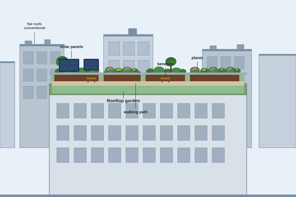
Answer: Two environmental benefits of rooftop gardens:
- Reducing the urban heat island effect – Plants absorb heat and provide shade, cooling the surrounding area and reducing energy use for air conditioning.
- Improving air quality – Plants absorb carbon dioxide and pollutants, releasing oxygen and filtering the air.
Marking notes:
- Award 1 mark for each valid benefit with brief explanation (2 marks total).
- Accept other valid benefits: reducing stormwater runoff, providing habitat for wildlife, insulating buildings, reducing noise pollution.
(b) [2 marks]
Answer: Rooftop gardens contribute to food security by allowing fresh vegetables, fruits, and herbs to be grown locally within the city. This reduces dependence on food imported from rural areas or other countries, provides access to fresh produce, and can supplement household food supplies, especially in areas with limited access to affordable fresh food.
Marking notes:
- Award 1 mark for identifying the link to local food production.
- Award 1 mark for explaining how this improves food security (e.g., access to fresh food, reduced dependence on imports, supplementing diets).
- Accept reference to urban farming or community gardens.
Teaching note: Food security means that all people have reliable access to sufficient, safe, and nutritious food. Urban agriculture, including rooftop gardens, can improve food security by bringing food production closer to consumers and reducing the vulnerability of food supply chains.
Question 13 [4 marks]
Answer: Two strategies cities can use to reduce their carbon footprint:
- Promoting public transport – Investing in efficient, affordable public transport systems (MRT, buses) reduces the number of private cars on the road, lowering carbon emissions from transport.
- Increasing renewable energy use – Installing solar panels on buildings and using wind or hydroelectric power reduces dependence on fossil fuels, which are a major source of carbon emissions.
Marking notes:
- Award 2 marks for each well-explained strategy (4 marks total).
- For each strategy: 1 mark for identifying the strategy, 1 mark for explaining how it reduces carbon footprint.
- Accept other valid strategies: energy-efficient buildings, waste reduction and recycling, carbon pricing, tree planting, promoting cycling and walking.
Teaching note: A carbon footprint is the total amount of greenhouse gases (including carbon dioxide and methane) generated by human activities. Cities are responsible for over 70% of global carbon emissions, making urban strategies crucial for climate change mitigation.
Question 14 [2 marks]
(a) [1 mark]
Answer: City A (350 litres per person per day).
(b) [1 mark]
Answer: City D may have the lowest water consumption because it has implemented strong water conservation measures, such as water pricing, public education campaigns, or efficient water infrastructure. Alternatively, it may be a city in a water-scarce region where water is expensive or limited.
Marking notes:
- Award 1 mark for any reasonable suggestion.
- Accept: "City D is in a dry region with limited water supply," or "City D has high water prices that discourage waste."
Teaching note: Water consumption varies greatly between cities due to factors including climate, income levels, water pricing, infrastructure quality, and cultural practices. Cities in water-scarce regions often have lower consumption due to conservation measures.
Question 15 [3 marks]
Answer: Water conservation helps cities become more sustainable by:
- Reducing water wastage – Using water more efficiently (e.g., low-flow fixtures, fixing leaks) ensures that limited water resources last longer and reduces the need for expensive new water sources.
- Lowering energy use – Treating and pumping water requires significant energy. Conserving water reduces energy consumption and associated carbon emissions.
- Protecting ecosystems – Reducing water extraction from rivers and groundwater helps maintain healthy aquatic ecosystems and biodiversity.
Marking notes:
- Award 1 mark for each valid point with explanation (up to 3 marks).
- Accept other valid points: reducing costs for households and governments, increasing resilience to droughts, reducing pollution from wastewater.
Teaching note: Water conservation is a key component of urban sustainability. Singapore's approach includes public education, water pricing, efficient appliances, and leak detection. The country has one of the lowest rates of water consumption in the developed world.
Section D: Geographical Investigation – Human Geography (Questions 16–20)
Question 16 [1 mark]
Answer: One suitable data collection method:
- Field observation / survey – Walking through the neighbourhood and recording the types of housing observed.
- Questionnaire survey – Asking residents about their housing type.
- Photography – Taking photographs of different housing types.
- Using online maps – Using Google Maps or OneMap to identify housing types.
Marking notes:
- Award 1 mark for any valid data collection method.
- Accept any reasonable method appropriate for investigating housing types.
Teaching note: Geographical investigation (fieldwork) is a core component of the Secondary 2 Geography curriculum. Students should be familiar with various data collection methods and their appropriate uses.
Question 17 [2 marks]
Answer:
- Advantage: Questionnaires can collect data from a large number of people quickly and efficiently, providing a representative sample of residents' views.
- Disadvantage: People may not be willing to respond, or they may give inaccurate answers (response bias), affecting the reliability of the data.
Marking notes:
- Award 1 mark for a valid advantage with brief explanation.
- Award 1 mark for a valid disadvantage with brief explanation.
- Accept other valid points: advantage – can collect both quantitative and qualitative data; disadvantage – time-consuming to analyse, language barriers, privacy concerns.
Teaching note: When conducting fieldwork, students should consider the strengths and limitations of each data collection method. Triangulation (using multiple methods) can improve the reliability of findings.
Question 18 [3 marks]
(a) [2 marks]
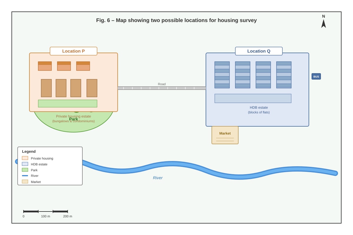
Answer: Location Q (the HDB estate) would be more suitable because it is near an MRT station and bus interchange, making it more accessible for the students. It also has a market and a mix of HDB blocks, which may offer a wider variety of housing types within a smaller area compared to the private housing estate at Location P.
Marking notes:
- Award 1 mark for choosing Location Q (or Location P with a strong justification).
- Award 1 mark for a valid justification related to the investigation purpose.
- Accept either location if the justification is reasonable and linked to the investigation aim.
(b) [1 mark]
Answer: One potential problem:
- Noise and distractions – Being near a busy MRT station and bus interchange may make it difficult to conduct interviews or surveys.
- Privacy concerns – Residents in HDB estates may be less willing to participate in surveys.
- Safety concerns – Students may need to be careful near busy roads and transport hubs.
Marking notes:
- Award 1 mark for any valid potential problem.
- Accept any reasonable problem related to the chosen location.
Teaching note: When planning fieldwork, students should consider practical issues such as accessibility, safety, time constraints, and potential biases in their data collection.
Question 19 [2 marks]
Answer: The data is numerical (quantitative) because it involves counting the number of storeys. One way to present this data is using a bar chart or histogram, which can show the frequency of buildings with different numbers of storeys.
Marking notes:
- Award 1 mark for identifying the data type as numerical/quantitative.
- Award 1 mark for suggesting an appropriate presentation method.
- Accept other presentation methods: pie chart (if grouped into categories like low-rise, mid-rise, high-rise), line graph, or table.
Teaching note: Numerical data involves numbers that can be measured or counted. Categorical data involves categories or labels (e.g., types of housing: HDB, condominium, landed). Different types of data require different presentation methods.
Question 20 [3 marks]
Answer: Studying human geography is important for planning sustainable cities because:
- Understanding population patterns – Human geography helps planners understand where people live, work, and move, allowing them to design efficient transport systems and locate services appropriately.
- Identifying social needs – Studying housing, income, and demographic data helps planners provide adequate housing, schools, healthcare, and other services for all residents.
- Balancing development and environment – Human geography examines how human activities interact with the environment, helping planners make decisions that minimise environmental harm while meeting human needs.
Marking notes:
- Award 1 mark for each valid point with explanation (up to 3 marks).
- Accept other valid points: understanding cultural preferences, predicting future growth, evaluating policy effectiveness, promoting social equity.
- Answers should demonstrate understanding of the link between human geography knowledge and sustainable urban planning.
Teaching note: Human geography provides the knowledge and tools needed to understand urban systems and plan for sustainable development. Geographers use concepts like space, place, and scale to analyse urban problems and develop solutions that balance economic, social, and environmental needs.
End of Answer Key