From Real Exams Quiz
Secondary 2 Geography Fieldwork Quiz
Free Sec 2 Geography Fieldwork quiz, HY3 Exam version, with questions, answers, and syllabus-aligned practice for Singapore students.
These static practice materials are generated from the site's syllabus and paper-generation workflow, with source and model context shown so students and parents can evaluate the material before use.
Questions
Secondary 2 Geography Quiz - Fieldwork
Name: ______________________
Class: _________
Date: ______________
Score: _______ / 40
Duration: 50 minutes
Total Marks: 40
Instructions:
- This quiz has 20 questions on the topic of Fieldwork.
- Section A: Multiple Choice (1 mark each)
- Section B: Short Structured Questions (2 marks each)
- Section C: Extended Fieldwork Tasks (3–4 marks each)
- Write your answers in the spaces provided. Use geographical terms where possible.
Section A: Multiple Choice (Questions 1–5)
-
What is the main purpose of conducting fieldwork in Geography?
A. To memorise textbook facts
B. To collect first-hand data about a place or issue
C. To avoid using maps
D. To complete homework faster
_____ (1 mark) -
Which of the following is a primary data collection method used in fieldwork?
A. Reading a friend’s essay
B. Conducting an interview with residents
C. Watching a documentary made overseas
D. Copying from a website
_____ (1 mark) -
A quadrat is most commonly used in fieldwork to:
A. Measure wind speed
B. Sample plants or small organisms in a fixed area
C. Draw a sketch map
D. Count vehicles at a junction
_____ (1 mark) -
Why is a sampling method such as random sampling used?
A. To ask only our friends
B. To make the data biased
C. To give every part of the study area a fair chance of being selected
D. To save time by studying one spot only
_____ (1 mark) -
What should a student do before starting fieldwork?
A. Obtain permission and carry out a risk assessment
B. Go directly without telling the teacher
C. Change the aim during the field trip
D. Ignore the weather forecast
_____ (1 mark)
Section B: Short Structured Questions (Questions 6–10)
-
State one advantage and one disadvantage of using a questionnaire in fieldwork.
Advantage: ___________________________ (1 mark)
Disadvantage: ________________________ (1 mark) -
Define the term “field sketch” in fieldwork.
_____________________________________ (2 marks) -
A student measures river depth at 5 points across a channel using a metre ruler. Give the equipment used and one precaution.
Equipment: _______________ (1 mark)
Precaution: _______________ (1 mark) -
Why is it important to record the date, time, and weather during fieldwork?
_____________________________________ (2 marks) -
State two types of secondary data that could support a fieldwork project on housing.
(i) _________________________ (1 mark)
(ii) ________________________ (1 mark)
Section C: Extended Fieldwork Tasks (Questions 11–20)
-
A class plans to study pedestrian flow outside a MRT station. Describe a suitable sampling method and explain why it is appropriate. (3 marks)
-
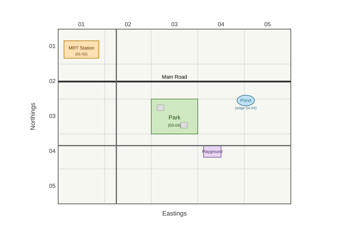
Study the map extract below. The class wants to do a litter count in a park. Suggest the most suitable grid square for the study and justify your choice using map evidence. (3 marks)

Generated map for Q12.
Suitable square: _______ (1 mark)
Justification: _____________________ (2 marks)
13. Explain how a transect line helps in studying coastal vegetation. (3 marks)
___________________________________________________________
___________________________________________________________
___________________________________________________________
-
A student records the following noise levels (in decibels) at a hawker centre: 65, 70, 72, 68, 75. Calculate the mean noise level. Show your working. (3 marks)
Working: _________________________
Mean: _______ dB (1 mark) -
Describe two ways to present fieldwork data so that patterns can be seen clearly. (2 marks)
(i) _________________________
(ii) ________________________ -
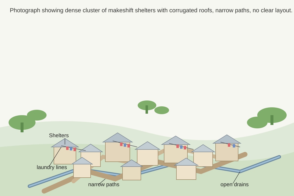
Study the photograph of a field site below. Describe two observable features that show this is an informal settlement, and explain one problem this creates for fieldwork. (4 marks)

Generated source_image for Q16.
Feature 1: ________________ (1 mark)
Feature 2: ________________ (1 mark)
Problem: __________________ (2 marks)
17. Your class carried out an interview survey on residents’ views of a new park. State two questions that should be asked and explain why they are useful. (3 marks)
Q1: _______________________ (1 mark)
Q2: _______________________ (1 mark)
Why useful: _______________ (1 mark)
-
A fieldwork aim is “To find out how land use changes with distance from the school.” Suggest a method to collect the data and one limitation. (3 marks)
Method: ___________________
Limitation: _______________ -
The table shows the number of bicycles counted at two locations. Draw a conclusion and suggest a reason. (3 marks)
| Location | Bicycles counted |
|---|---|
| Near park | 42 |
| Near mall | 15 |
Conclusion: ________________ (1 mark)
Reason: ___________________ (2 marks)
20. Evaluate the usefulness of fieldwork for understanding sustainable cities. Use a specific example from a possible study. (4 marks)
___________________________________________________________
___________________________________________________________
___________________________________________________________
___________________________________________________________
Answers
Secondary 2 Geography Quiz - Fieldwork: Answer Key
Total Marks: 40
Topic: Fieldwork
Section A: Multiple Choice
-
B (1 mark)
Teaching note: Fieldwork means going out to collect first-hand information. It is not about memorising facts (A), avoiding maps (C), or saving time (D). Geographers use fieldwork to observe real places. -
B (1 mark)
Teaching note: Primary data is collected by the student themselves. An interview is direct collection. A documentary (C) or website (D) is secondary; a friend’s essay (A) is not data. -
B (1 mark)
Teaching note: A quadrat is a square frame placed on the ground to count plants or small animals in that area. It is not for wind (A), sketching (C), or traffic (D). -
C (1 mark)
Teaching note: Random sampling avoids bias by giving equal chance. It is not for bias (B) or studying one spot (D). -
A (1 mark)
Teaching note: Safety and permission are required before any field trip. Going without telling (B), changing aim on site (C), or ignoring weather (D) are unsafe.
Section B: Short Structured Questions
-
(2 marks total)
Advantage: e.g., “Can collect views from many people quickly.” (1 mark)
Disadvantage: e.g., “People may give untruthful answers or misunderstand questions.” (1 mark)
Note: Accept any reasonable pair. Mark one mark each. -
(2 marks)
A field sketch is a free-hand drawing of a landscape or site made during fieldwork, showing key features and labels. (2 marks for clear definition with “free-hand”/“drawn on site” and “labelled features”.)
Teaching note: It is not a photo; it highlights what the student thinks is important. -
(2 marks)
Equipment: metre ruler (or ranging pole + tape) (1 mark)
Precaution: e.g., “Ensure ruler is vertical and read at eye level to avoid parallax error.” (1 mark) -
(2 marks)
To allow data to be compared or repeated later, and because weather/light can affect observations (e.g., rain may reduce pedestrian count). (2 marks: 1 for repeatability, 1 for environmental effect) -
(2 marks)
Any two: census data, housing maps, planning reports, newspaper articles, government statistics. (1 mark each)
Section C: Extended Fieldwork Tasks
-
(3 marks)
Method: Systematic sampling (e.g., count every 10th person, or at 10-minute intervals). (1 mark)
Why appropriate: Covers different times, reduces bias, manageable for a class. (2 marks: 1 for coverage, 1 for practicality)
Marking descriptor: 3 = clear method + two valid reasons; 2 = method + one reason; 1 = method only. -
(3 marks)
Suitable square: 03-04 (1 mark)
Justification: Park is mainly in 03-04, few buildings so safe and accessible, likely public space for litter count. (2 marks: reference to map evidence)
Image support: Map must show park in 03-04, grid numbers. -
(3 marks)
A transect line is a straight line across the coast; students record vegetation at set points. (1 mark) It shows zonation (changes with distance). (1 mark) Helps compare species from sea to land. (1 mark) -
(3 marks)
Working: 65 + 70 + 72 + 68 + 75 = 350; 350 ÷ 5 = 70 (2 marks for working)
Mean: 70 dB (1 mark) -
(2 marks)
Any two: bar graph, line graph, pie chart, map, field sketch with annotations. (1 mark each) -
(4 marks)
Feature 1: Makeshift shelters / corrugated roofs (1 mark)
Feature 2: Narrow irregular paths / no planned layout (1 mark)
Problem: Difficult to move safely, hard to get consent, map may not show paths. (2 marks for clear problem with link)
Image support: Photo shows self-built structures, irregular layout. -
(3 marks)
Q1: “Do you use the park? Why?” (1 mark)
Q2: “What improvements do you want?” (1 mark)
Useful: Gives user view, helps evaluate park success. (1 mark) -
(3 marks)
Method: Walk outwards from school, record land use every 100 m. (2 marks)
Limitation: E.g., time constraint, private areas blocked. (1 mark) -
(3 marks)
Conclusion: More bicycles near park than mall. (1 mark)
Reason: Park attracts cyclists; mall area may restrict biking or have less bike parking. (2 marks) -
(4 marks)
Fieldwork lets students see real examples (1 mark). E.g., studying green features in housing estate (1 mark). Helps understand sustainability beyond books (1 mark). Evaluation: direct observation shows true conditions but limited by small sample (1 mark).
Descriptor: 4 = example + evaluation + link to sustainable cities; 3 = example + link; 2 = basic point.
Free quiz and exam paper access
Enter your details to view this paper
Your access is remembered on this device.