AI Generated Quiz
Secondary 1 History Singapore Southeast Asia Quiz
Free Sec 1 History Singapore SEA quiz, HY3 AI version, with questions, answers, and syllabus-aligned practice for Singapore students.
These static practice materials are generated from the site's syllabus and paper-generation workflow, with source and model context shown so students and parents can evaluate the material before use.
Questions
Free quiz and exam paper access
Enter your details to view this paper
Your access is remembered on this device.
Answers
Secondary 1 History Quiz - Answer Key (Singapore Southeast Asia)
Total Marks: 40
Level: Secondary 1
Note: This is syllabus-first practice content generated from LLM-inferred templates. It is not claimed to be from past-year papers.
Section A: Short Answer (1–8) — 1 mark each
1. Temasek
Teaching note: In the 1300s, early Singapore was known as Temasek. It was already a trading port because of its location.
2. Strait of Malacca
Teaching note: The Strait of Malacca is the waterway between the Malay Peninsula and Sumatra. Ships used it for trade between India and China.
3. Srivijaya
Teaching note: The fall of the Srivijaya Empire created space for new trading centres like Temasek to grow. (Other acceptable: Melaka rose later; any empire that declined is fine if reasoned, but Srivijaya is the syllabus example.)
4. Stamford Raffles
Teaching note: Sir Stamford Raffles established a British trading post in Singapore in 1819.
5. Free port
Teaching note: A free port means no taxes on goods traded. This attracted many ships and traders.
6. Suez Canal
Teaching note: The Suez Canal opened in 1869. It shortened the sea route from Europe to Asia, so more ships passed Singapore.
7. Chinese (or Indian / Malay / European)
Teaching note: Many Chinese and Indian migrants came to Singapore for work in the 1800s.
8. 1942
Teaching note: Japanese forces occupied Singapore in 1942 during World War II.
Section B: Source-Based (9–14)
9. [2m]
Answer: Source A tells us that early Singapore was a meeting point for ships from India and China, and it was a free port with no tax, so many traders came.
Marking: 1m for “ships from India and China met there”; 1m for “no tax / free port attracted traders”.
Teaching note: A student should pick evidence from the letter: “Ships from India and China meet here” and “pay no tax”.
10. [2m]
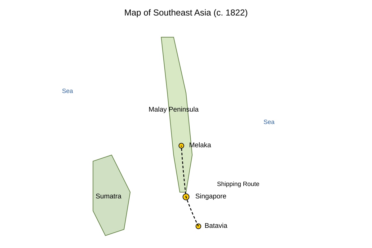
Answer: The map shows Singapore at the tip of the Malay Peninsula near shipping routes from Batavia to Melaka, so ships could easily stop there for trade.
Marking: 1m for location at tip of peninsula; 1m for being on/near shipping route.
Teaching note: The <image_placeholder> map must show Singapore at the southern tip with route nearby. This location made it a natural stopover.
11. [5m]
Answer: Both Sources A and C say Singapore grew because of its position on trade routes and because it attracted ships.
- Similarity 1: Source A says ships from India and China met in Singapore; Source C says Singapore was on the route between India and China. (2m: identify + evidence)
- Similarity 2: Source A shows traders came because of no tax; Source C shows British chose it for trade. Both show trade was the main reason for growth. (2m)
- Explanation: This suggests Singapore’s growth was due to geography and trade policy. (1m)
Teaching note: Compare, do not describe separately. Use “Both sources…” and give proof from each.
12. [4m]
Answer: We can infer the local people accepted the British deal but saw big changes. Source D says the British “made a deal with our chiefs” and “our village became a busy town”, so they noticed foreign ships and growth.
Marking: 1m inference of acceptance/deal; 1m evidence; 1m inference of change/busy town; 1m evidence.
Teaching note: Inference means reading between the lines. The account is calm, not angry, so they accepted it but saw their life change.
13. [4m]
Answer: Source A is fairly reliable for British trade because it is a merchant’s letter from 1820, close to the time. But it may be biased because the merchant wanted to praise the port.
Marking: 2m for reliable (first-hand, right time); 2m for limitation (bias, one view).
Teaching note: Reliability = is it trustworthy? Use author, date, purpose. A merchant may exaggerate benefits.
14. [5m]
Answer: Both C and D say the British made an agreement with local rulers to start Singapore.
- Similarity 1: Source C says Raffles signed a treaty with local rulers; Source D says British made a deal with chiefs. (2m)
- Similarity 2: Both say this led to growth: C says trade route use; D says many ships arrived and village became town. (2m)
- Explanation: Both show founding was through local agreement and brought change. (1m)
Teaching note: Link the treaty/deal in both. Do not say they are the same type of source; focus on content similarity.
Section C: Structured Response (15–20)
15. [4m]
(a) Rise of Melaka as the dominant port took trade away from Temasek. [2m]
(b) Portuguese and Dutch control of Melaka made the region’s trade centre move, reducing Temasek’s role. [2m]
Teaching note: After Melaka grew, Temasek declined. Later powers fought over Melaka, not Temasek.
16. [4m]
(a) Economic opportunity: jobs and trade in Singapore’s free port. [2m]
(b) Relative safety / better life compared to conflict or poverty at home. [2m]
Teaching note: Pull factors are reasons that attract people to come. (Push = reasons to leave home.)
17. [4m]
(a) Provided labour for port and infrastructure (e.g., Chinese coolies). [2m]
(b) Built businesses and clan networks that expanded trade (e.g., Chinese merchants). [2m]
Teaching note: Migrants did not just live here; they built the economy.
18. [4m]
Answer: The Suez Canal (1869) shortened the Europe–Asia route, so ships used Singapore as a stop, increasing trade and port growth. [2m for canal effect, 2m for link to Singapore growth]
Teaching note: External development = something outside Singapore that changed it.
19. [4m]
(a) British focused on defending Europe, leaving Singapore weak. [2m]
(b) Japanese used land attack through Malaya, which British did not expect. [2m]
Teaching note: Syllabus says British military strategy was unprepared for land invasion.
20. [4m]
Answer: Singapore’s location on the India–China route made Temasek a trading port, and later helped Raffles choose it for a British free port. [2m location, 2m link to both periods]
Teaching note: Same geography helped in both Temasek and British times.