AI Generated Quiz
Secondary 1 History Ancient Civilisations Quiz
Free Sec 1 History Ancient Civilisations quiz, HY3 AI version, with questions, answers, and syllabus-aligned practice for Singapore students.
These static practice materials are generated from the site's syllabus and paper-generation workflow, with source and model context shown so students and parents can evaluate the material before use.
Questions
Free quiz and exam paper access
Enter your details to view this paper
Your access is remembered on this device.
Answers
Secondary 1 History Quiz - Ancient Civilisations (Answer Key)
Total Marks: 40
Topic: Ancient Civilisations
Note: Syllabus-first practice generated from LLM-inferred templates; not past-year exam derived.
Section A: Short Questions (1 mark each)
1. Indus River (or Indus Valley / River Indus) [1]
Teaching note: The Indus Valley Civilisation (around 2500 BCE) grew along the Indus River in present-day Pakistan and northwest India. Key idea: civilisations often form near rivers for water and farming.
2. Srivijaya (or Temasek / Melaka / any early SEA port) [1]
Teaching note: Early Southeast Asian polities like Srivijaya (Sumatra) traded with India and China. Temasek (Singapore, 1300s) is also acceptable per syllabus.
3. Pataliputra [1]
Teaching note: The Mauryan Empire (c. 322–185 BCE) had its capital at Pataliputra (modern Patna, India).
4. Great Bath [1]
Teaching note: Mohenjo-daro's Great Bath is a large waterproof tank; shows engineering and possibly ritual bathing.
5. Ashoka [1]
Teaching note: After the bloody Kalinga war, Emperor Ashoka adopted Buddhism and sent missionaries abroad.
6. Steatite (or clay / terracotta / stone) [1]
Teaching note: Indus seals were often steatite; used for trade marking. Any reasonable material accepted.
7. Temasek [1]
Teaching note: Temasek was the old name for Singapore in the 1300s, a trading port before Raffles.
8. Indus Valley Civilisation [1]
Teaching note: Their cities (Harappa, Mohenjo-daro) had grid streets, showing planning.
9. Spices (or gold / tin / rice / silk / ceramics) [1]
Teaching note: SEA ports traded local goods like spices and tin with bigger neighbours.
10. Indus script [1]
Teaching note: The Indus script on seals is undecoded; we cannot read their writing yet.
Section B: Structured Questions (2 marks each)
11. [2] Mark breakdown: 1m per feature.
(a) Grid street layout (streets crossed at right angles).
(b) Drainage system (covered drains on both sides of streets).
Other acceptable: standard brick sizes, citadel, Great Bath.
Teaching note: City planning shows central authority and concern for hygiene.
12. [2] Mark breakdown: 1m per reason.
(a) Strong army and central government under the king.
(b) Good administration with officials collecting tax and spreading laws.
Teaching note: The Mauryans used a bureaucracy described by Megasthenes; Ashoka's edicts show control.
13. [2] Mark breakdown: 1m per group.
(a) Indian traders (from India).
(b) Chinese traders (from China).
Also accept: Arabs, local Malays.
Teaching note: Geography placed SEA between two big civilisations.
14. [2] Mark breakdown: 1m per achievement.
(a) Planned cities with drainage.
(b) Standardised weights and measures / seals for trade.
Teaching note: Achievements show advanced society without modern tools.
15. [2] Mark breakdown: 1m per way.
(a) Sea trade routes linked them to India and China.
(b) Spread of religion (e.g., Buddhism from India to SEA).
Teaching note: Connection = exchange of goods and ideas.
16. [2] Mark breakdown: 1m per source.
(a) Archaeological finds (pottery, seals).
(b) Written records (texts, inscriptions).
Teaching note: Historians use evidence because no video exists from then.
Section C: Source-Based / Explanation Questions (3 marks each)
17. [3] Marking descriptors:
- 1m: Inference that they valued cleanliness / public health.
- 1m: Reference to drains on both sides of streets from source.
- 1m: Explanation that planning shows organised government.
Sample answer: We can infer Indus Valley society cared about cleanliness because Source A says drains were on both sides of streets (1m). This shows public health was important (1m). Such planning suggests a strong central government organised city life (1m).
Common mistake: Only restating source without inference.
18. [3] Marking descriptors:
- 1m: Useful because it shows Mauryan spread of religion/culture.
- 1m: It is a text possibly from the period (if old text = near time).
- 1m: Limitation: may be biased to praise king; no other source cross-check.
Sample answer: Source B is useful as it tells of teachers sent to spread religion, showing cultural reach (1m). As an old text it may be close to the time (1m). But it may be biased to glorify the king and needs cross-checking (1m).
Teaching note: Usefulness ≠ fully reliable.
19. [3] Marking descriptors:
- 1m: Location on sea routes between India and China.
- 1m: Natural harbours / rivers helped ships stop.
- 1m: They acted as middlemen exchanging goods.
Sample answer: SEA ports were on the Indian Ocean and South China Sea (1m), so ships from India and China could stop (1m). This let them trade and become middlemen (1m).
Teaching note: Geography = destiny for trade ports.
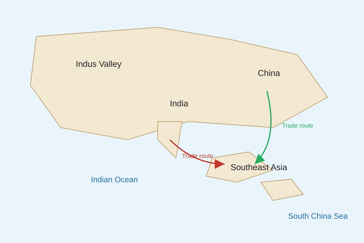
20. [3] Marking descriptors (based on placeholder map):
- 1m: Map shows arrows from India and China to SEA.
- 1m: This means SEA received goods from both civilisations.
- 1m: Trade linked them into a network across Asia.
Sample answer: The map shows trade routes from India and China to Southeast Asia (1m), meaning goods moved between civilisations (1m). Thus ancient civilisations were connected by sea trade across Asia (1m).
Expected visual: arrows labelled from Indus/India and China to SEA ports; student should read arrows as connections.