Secondary 1 History Quiz - Singapore Southeast Asia
Name: ___________________________
Class: ___________________________
Date: ___________________________
Score: ___________ / 40
Duration: 60 minutes
Total Marks: 40
Instructions:
- This quiz has 20 questions on Singapore and Southeast Asia.
- Section A: Source-Based Questions (Q1–8)
- Section B: Structured Response (Q9–15)
- Section C: Short Answer & Chronology (Q16–20)
- Write your answers in the spaces provided. Use full sentences where instructed.
Section A: Source-Based Questions (16 marks)
Study Source A below for Questions 1–2.
Source A: A letter written in 1819 by a British merchant in Malacca to his friend in London:
"Raffles has established a new settlement at Singapore. The place is wonderfully situated along the main trading route between India and China. Already small vessels from the surrounding Malay states bring spices and cloth. The Dutch are unhappy, for they fear loss of their own trade in the region."
Q1. What can you infer from Source A about why Raffles chose Singapore as a British trading post? Explain your answer. [2m]
Q2. What does Source A tell you about the reaction of the Dutch to the founding of Singapore? [2m]
Study Sources B and C below for Questions 3–5.
Source B: Extract from a history textbook (2022):
"In the 1300s, Temasek was a small but busy trading port. Chinese and Indian traders visited the settlement. Its location allowed it to benefit from the sea route between the Indian Ocean and the South China Sea."
Source C: A map drawn by a Portuguese sailor in 1500 showing "Temasik" near the Melaka Strait with markings of trade ships from Gujarat and China.
Q3. Study Source B. What can you infer about the people who came to Temasek in the 1300s? Explain your answer. [2m]
Q4. Study Sources B and C. How are these sources similar about early Temasek? Explain your answer. [4m]
Q5. Study Source C. What is one limitation of using this map as evidence about Temasek's trade? [2m]
Study Source D below for Questions 6–8.
Source D: Diary of a Chinese migrant, 1910:
"I left Guangdong because floods destroyed our crops. In Singapore I found work at the rubber plantation. Many like me send money home. The port is full of ships from Europe and America."
Q6. What can you infer from Source D about the push factor that brought the author to Singapore? [2m]
Q7. What does Source D tell you about Singapore's port in 1910? [1m]
Q8. Study Source D. What is the view of the migrant about life in Singapore? Explain your answer. [1m]
Section B: Structured Response (14 marks)
Q9. Explain two reasons why Singapore's location helped it become a trading port in the 1300s. [4m]
(a) _______________________________________________________
(b) _______________________________________________________
Q10. Describe two ways the opening of the Suez Canal in 1869 affected Singapore's port growth. [4m]
(a) _______________________________________________________
(b) _______________________________________________________
Q11. Explain how the rise of Melaka in the 1400s led to the decline of Temasek. [3m]
Q12. Study the map below and answer the question.

Generated map for Q12.
Based on the map, why was Temasek's location useful for trade? [1m]
Q13. Explain one reason why the British wanted a trading post in Southeast Asia in the early 1800s. [2m]
Section C: Short Answer & Chronology (10 marks)
Q14. Name one commodity traded in Singapore under British rule that came from the region's plantations. [1m]
Q15. Put the following events in correct chronological order. Write 1 (earliest) to 4 (latest). [4m]
___ Founding of British Singapore (1819)
___ Rise of Melaka as dominant port (1400s)
___ Temasek as trading port (1300s)
___ Opening of Suez Canal (1869)
Q16. What was the name of the strait that gave Singapore and Melaka their trading advantage? [1m]
Q17. Give one pull factor that attracted Indian migrants to Singapore under British rule. [1m]
Q18. Which European country controlled Melaka before the British came to Singapore? [1m]
Q19. What term describes Singapore's policy of no tax on imported goods that helped trade? [1m]
Q20. From the source below, answer the question.
Source E: "The Johor Sultanate was formed after the fall of Melaka to the Portuguese in 1511."
Who formed the Johor Sultanate? [1m]
</stage3_quiz_answers_md>
Secondary 1 History Quiz Answers - Singapore Southeast Asia
Total Marks: 40
Topic: Singapore & Southeast Asia
Section A: Source-Based Questions
Q1. [2m]
- Inference: Raffles chose Singapore because of its strategic location on the trading route between India and China (1m).
- Explanation: Source A says the place is "wonderfully situated along the main trading route between India and China," so we infer location was the main reason (1m).
- Teaching note: Inference means reading between the lines. The source does not say "Raffles chose it for location" directly, but the clue is there.
- Common mistake: Restating "Raffles established a settlement" without explaining the why.
Q2. [2m]
- Answer: The Dutch were unhappy / feared loss of their own trade (1m) because they saw Singapore as competition (1m).
- Evidence: "The Dutch are unhappy, for they fear loss of their own trade."
- Teaching note: This is direct extraction, not inference. Use the source's words.
Q3. [2m]
- Inference: Traders from China and India visited Temasek (1m), so it was a multi-ethnic trading stop (1m).
- Explanation: Source B mentions "Chinese and Indian traders visited," showing connection to wider Asia.
- Teaching note: A trading port means people from different lands came; that is the inference.
Q4. [4m] Mark breakdown: 2 similarities x 2m each (identify + explain).
- Similarity 1: Both show Temasek was a trading port (2m). Source B says "busy trading port"; Source C shows ships from Gujarat and China labelled at "Temasik."
- Similarity 2: Both show connection to India-China trade (2m). Source B mentions route between Indian and South China Seas; Source C marks ships from Gujarat (India) and China.
- Teaching note: For similarity questions, always cite both sources and explain.
Q5. [2m]
- Limitation: The map is drawn by a Portuguese sailor, so it may show only what they observed or have errors (1m); also it is from 1500, after Temasek's decline, so may not show 1300s reality (1m).
- Teaching note: Limitations relate to origin, purpose, time.
Q6. [2m]
- Inference: Push factor was natural disaster / floods destroying crops (1m) causing poverty (1m).
- Evidence: "left Guangdong because floods destroyed our crops."
Q7. [1m]
- Answer: The port was busy with ships from Europe and America (full of ships).
Q8. [1m]
- View: He viewed Singapore as a place of work opportunity (1m). Evidence: found work at rubber plantation.
Section B: Structured Response
Q9. [4m] 2 reasons x 2m.
- (a) On route between India and China (2m): Ships naturally passed by, making trade easy.
- (b) Part of sea route between Indian and South China Seas (2m): Allowed exchange of goods from two oceans.
- Teaching note: Location is the recurring theme in Unit 1.
Q10. [4m] 2 ways x 2m.
- (a) Faster travel from Europe (2m): Suez Canal shortened route to Asia, more ships came.
- (b) Increased trade volume (2m): More goods passed through Singapore port.
- Teaching note: External development = something outside Singapore helping it grow.
Q11. [3m]
- Melaka became dominant port (1m), attracted traders away from Temasek (1m), so Temasek declined (1m).
- Teaching note: Cause (rise of Melaka) → effect (Temasek decline).
Q12. [1m]
- Answer: It was on the strait between Indian Ocean and South China Sea, so ships had to pass near it.
- Image note: Map must show Temasek on Strait of Malacca with route arrows.
Q13. [2m]
- Reason: To compete with Dutch trade / secure British trade route (2m).
- Teaching note: Anglo-Dutch rivalry is key context.
Section C: Short Answer & Chronology
Q14. [1m] Rubber (or tin).
Q15. [4m] 3 (Temasek 1300s), 2 (Melaka 1400s), 1 (1819), 4 (1869). 1m each.
Q16. [1m] Strait of Malacca.
Q17. [1m] Job opportunities (or send money home).
Q18. [1m] Portuguese (then Dutch).
Q19. [1m] Free port.
Q20. [1m] The Johor Sultanate was formed by those after fall of Melaka (Malay rulers / successors).
</stage3_quiz_answers_md>
<stage3_quiz_md>
Secondary 1 History Quiz - Singapore Southeast Asia
Name: ___________________________
Class: ___________________________
Date: ___________________________
Score: ___________ / 40
Duration: 60 minutes
Total Marks: 40
Instructions:
- This quiz has 20 questions on Singapore and Southeast Asia.
- Section A: Source-Based Questions (Q1–8)
- Section B: Structured Response (Q9–15)
- Section C: Short Answer & Chronology (Q16–20)
- Write your answers in the spaces provided. Use full sentences where instructed.
Section A: Source-Based Questions (16 marks)
Study Source A below for Questions 1–2.
Source A: A letter written in 1819 by a British merchant in Malacca to his friend in London:
"Raffles has established a new settlement at Singapore. The place is wonderfully situated along the main trading route between India and China. Already small vessels from the surrounding Malay states bring spices and cloth. The Dutch are unhappy, for they fear loss of their own trade in the region."
Q1. What can you infer from Source A about why Raffles chose Singapore as a British trading post? Explain your answer. [2m]
Q2. What does Source A tell you about the reaction of the Dutch to the founding of Singapore? [2m]
Study Sources B and C below for Questions 3–5.
Source B: Extract from a history textbook (2022):
"In the 1300s, Temasek was a small but busy trading port. Chinese and Indian traders visited the settlement. Its location allowed it to benefit from the sea route between the Indian Ocean and the South China Sea."
Source C: A map drawn by a Portuguese sailor in 1500 showing "Temasik" near the Melaka Strait with markings of trade ships from Gujarat and China.
Q3. Study Source B. What can you infer about the people who came to Temasek in the 1300s? Explain your answer. [2m]
Q4. Study Sources B and C. How are these sources similar about early Temasek? Explain your answer. [4m]
Q5. Study Source C. What is one limitation of using this map as evidence about Temasek's trade? [2m]
Study Source D below for Questions 6–8.
Source D: Diary of a Chinese migrant, 1910:
"I left Guangdong because floods destroyed our crops. In Singapore I found work at the rubber plantation. Many like me send money home. The port is full of ships from Europe and America."
Q6. What can you infer from Source D about the push factor that brought the author to Singapore? [2m]
Q7. What does Source D tell you about Singapore's port in 1910? [1m]
Q8. Study Source D. What is the view of the migrant about life in Singapore? Explain your answer. [1m]
Section B: Structured Response (14 marks)
Q9. Explain two reasons why Singapore's location helped it become a trading port in the 1300s. [4m]
(a) _______________________________________________________
(b) _______________________________________________________
Q10. Describe two ways the opening of the Suez Canal in 1869 affected Singapore's port growth. [4m]
(a) _______________________________________________________
(b) _______________________________________________________
Q11. Explain how the rise of Melaka in the 1400s led to the decline of Temasek. [3m]
Q12. Study the map below and answer the question.
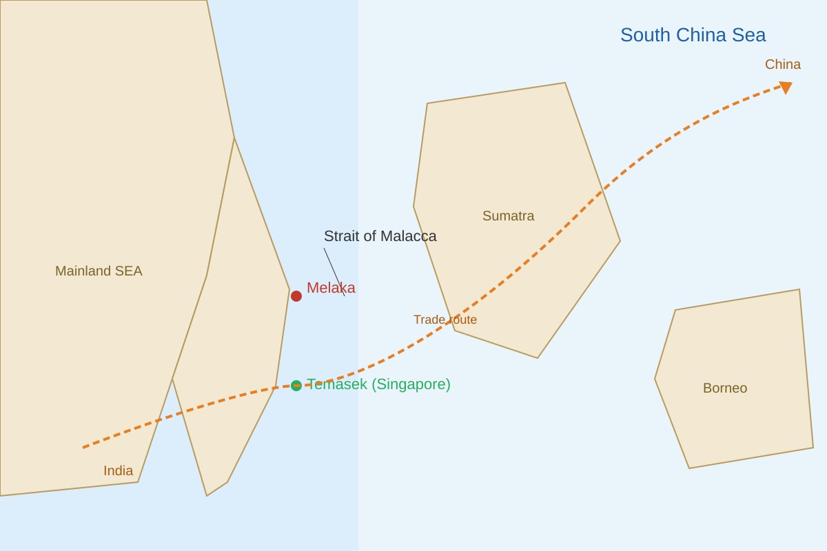
Generated map for Q12.
Based on the map, why was Temasek's location useful for trade? [1m]
Q13. Explain one reason why the British wanted a trading post in Southeast Asia in the early 1800s. [2m]
Section C: Short Answer & Chronology (10 marks)
Q14. Name one commodity traded in Singapore under British rule that came from the region's plantations. [1m]
Q15. Put the following events in correct chronological order. Write 1 (earliest) to 4 (latest). [4m]
___ Founding of British Singapore (1819)
___ Rise of Melaka as dominant port (1400s)
___ Temasek as trading port (1300s)
___ Opening of Suez Canal (1869)
Q16. What was the name of the strait that gave Singapore and Melaka their trading advantage? [1m]
Q17. Give one pull factor that attracted Indian migrants to Singapore under British rule. [1m]
Q18. Which European country controlled Melaka before the British came to Singapore? [1m]
Q19. What term describes Singapore's policy of no tax on imported goods that helped trade? [1m]
Q20. From the source below, answer the question.
Source E: "The Johor Sultanate was formed after the fall of Melaka to the Portuguese in 1511."
Who formed the Johor Sultanate? [1m]