From Real Exams Exam Paper
Secondary 1 History Semestral Assessment 2 (End of Year) Paper 5
Free Sec 1 History SA2 Paper 5, Kimi2.6 Exam version, with questions, answers, and syllabus-aligned practice for Singapore students.
These static practice materials are generated from the site's syllabus and paper-generation workflow, with source and model context shown so students and parents can evaluate the material before use.
Questions
TuitionGoWhere Exam Practice (AI) - History Secondary 1
TuitionGoWhere Secondary School (AI)
| Subject: | History |
| Level: | Secondary 1 (Express/Normal Academic) |
| Paper: | SA2 Practice Paper |
| Version: | 5 of 5 |
| Duration: | 1 hour 15 minutes |
| Total Marks: | 60 |
Name: _________________________________ Class: _________________________________ Date: _________________________________
INSTRUCTIONS TO CANDIDATES
- Write your name, class, and date in the spaces provided above.
- This paper consists of THREE sections: Section A, Section B, and Section C.
- Answer ALL questions.
- For Section A, write your answers in the spaces provided.
- For Sections B and C, write your answers in the spaces provided. If you need more space, use the additional pages at the back of this paper.
- Use of correction fluid is not allowed.
SECTION A: SOURCE-BASED QUESTIONS (20 marks)
Answer all questions in this section.
Study the sources below and answer Questions 1 to 4.
Source A: An excerpt from a letter written by William Farquhar, the first Resident of Singapore, to the British East India Company in 1819.
"The island of Singapore occupies a position of the first importance for trade. It lies at the very gateway between the Indian Ocean and the China Sea, commanding the narrow strait through which all vessels must pass. The local population, mostly fishermen and Orang Laut, have been most welcoming, and Temenggong Abdul Rahman has shown himself willing to sign a treaty granting us the right to establish a trading post. I am convinced that this settlement will soon rival Penang in commercial importance, given its superior location."
Source B: A modern historian's analysis of Raffles' motivations for founding Singapore, published in 2015.
"While Raffles spoke of free trade and the expansion of British commerce, his actions must be understood within the context of Anglo-Dutch rivalry. The British were deeply concerned that Dutch expansion in the Riau-Lingga archipelago would threaten their China trade. Singapore was, in strategic terms, a preemptive strike—a British foothold that could check Dutch influence while opening new markets. The 'founding' was thus as much about geopolitical competition as it was about commerce."
Source C: A population table from an 1828 report by the British Resident of Singapore.
| Ethnic Group | Population (1824) | Population (1828) |
|---|---|---|
| Chinese | 3,317 | 6,729 |
| Malays | 4,790 | 4,802 |
| Indians | 756 | 1,796 |
| Europeans | 74 | 117 |
| Others | 209 | 358 |
| Total | 9,146 | 13,802 |
Question 1 (6 marks)
Study Sources A and B.
(a) What can you tell from Source A about why the British were interested in establishing a settlement in Singapore? [3]
(b) How far does Source B agree with Source A about British motivations for founding Singapore? Explain your answer. [3]
Question 2 (5 marks)
Study Source C.
What does Source C tell you about the development of Singapore's population between 1824 and 1828? Explain your answer using details from the source.
Question 3 (5 marks)
Study all three sources.
How useful are Sources A and C to a historian studying the early success of British Singapore? In your answer, consider both the information provided and the nature of the sources.
Question 4 (4 marks)
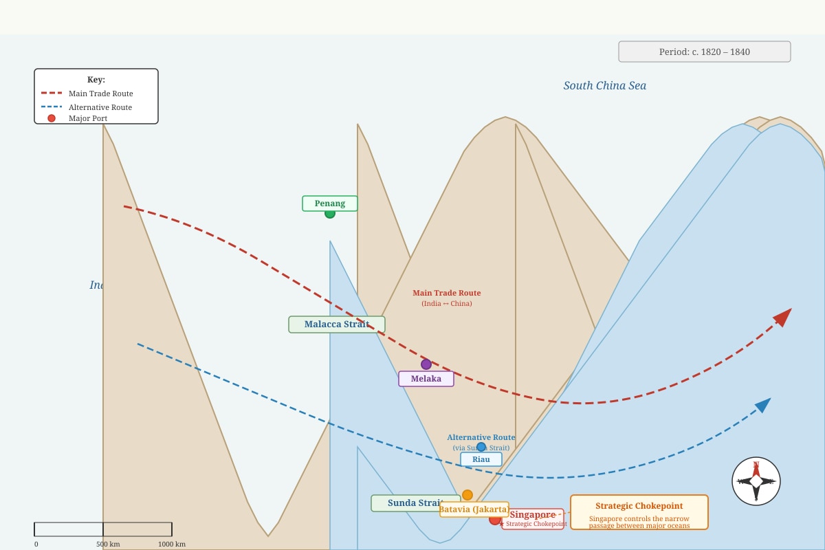
Generated map for Q4.
Study the map in the image above.
Explain why Singapore's location was more advantageous for trade than that of Penang. Support your answer with evidence from the map and your own knowledge.
Section A Total: 20 marks
SECTION B: STRUCTURED RESPONSE QUESTIONS (25 marks)
Answer all questions in this section.
Question 5 (5 marks)
(a) Name two indigenous groups that lived in the Singapore region before the arrival of the British in 1819. [2]
(b) Explain one reason why these indigenous groups had settled in the Singapore region. [3]
Question 6 (6 marks)
Explain how the Anglo-Dutch Treaty of 1824 resolved British and Dutch rivalry in Southeast Asia, and how this benefited the development of Singapore.
Question 7 (7 marks)
Image pending generation: diagram for Q7.
Study the diagram of the colonial shophouse above.
(a) What does the design of the shophouse tell us about the different cultural influences in colonial Singapore? [3]
(b) Explain why this type of building was suitable for Singapore's tropical climate and its role as a trading port. [4]
Question 8 (7 marks)
"The main reason for Singapore's growth as a major port in the 19th century was the free trade policy adopted by the British." How far do you agree with this statement? Explain your answer.
Section B Total: 25 marks
SECTION C: KNOWLEDGE AND APPLICATION (15 marks)
Answer all questions in this section.
Question 9 (8 marks)
Read the extract below and answer the questions that follow.
"By the 1870s, Singapore had become the centre of a remarkable regional trade network. Chinese merchants dominated the import of textiles and opium from India, while British firms handled the export of tin and rubber from the Malay Peninsula. The port also served as a collection point for labourers—Indian indentured workers for plantation agriculture, and Chinese coolies for mining and construction throughout the region."
(a) Identify two types of goods traded through Singapore in the 1870s, as mentioned in the extract. [2]
(b) Using the extract and your own knowledge, explain why Singapore became an important centre for labour migration in the 19th century. [3]
(c) The extract mentions different ethnic groups involved in trade. Explain how the presence of these different communities contributed to both opportunities and tensions in colonial Singapore. [3]
Question 10 (7 marks)
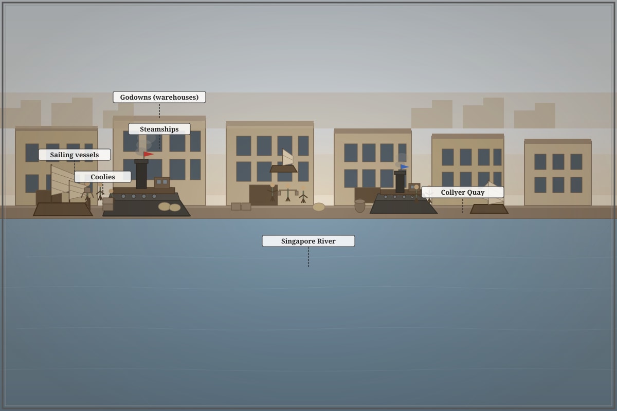
Generated photograph for Q10.
Study the photograph of Singapore harbour above.
(a) Using details from the photograph, describe two features of Singapore's port in the late 19th century. [2]
(b) Explain how developments in port infrastructure and shipping technology helped Singapore maintain its position as a leading trading centre in Southeast Asia by 1900. [5]
Section C Total: 15 marks
END OF PAPER
TOTAL: 60 MARKS
ADDITIONAL WRITING SPACE
If you need more space, write your answers clearly below. Remember to indicate the question number.
Answers
TuitionGoWhere Exam Practice (AI) - History Secondary 1
SA2 Practice Paper Answer Key - Version 5 of 5
Subject: History Level: Secondary 1 (Express/Normal Academic) Total Marks: 60
SECTION A: SOURCE-BASED QUESTIONS (20 marks)
Question 1 (6 marks)
(a) What can you tell from Source A about why the British were interested in establishing a settlement in Singapore? [3]
Answer and Marking Guidance:
| Mark Point | Explanation |
|---|---|
| 1m | Commercial/trade reasons: Singapore's strategic location at the gateway between the Indian Ocean and China Sea, commanding the narrow strait through which all vessels must pass |
| 1m | Geopolitical/strategic position: "position of the first importance for trade" – controlling a key chokepoint for regional commerce |
| 1m | Local cooperation and feasibility: Temenggong Abdul Rahman was willing to sign a treaty; local population was welcoming, making establishment practical |
Teaching Note: Source A is a primary source from 1819, written by the first Resident immediately after the founding. Farquhar emphasizes practical advantages—location, local cooperation, and commercial potential. Students should identify that Farquhar frames Singapore as naturally suited for trade due to geography, not just British planning.
Common Mistake: Students may mention Raffles instead of Farquhar, or confuse this with later developments. The source specifically credits Farquhar as the writer.
(b) How far does Source B agree with Source A about British motivations for founding Singapore? Explain your answer. [3]
Answer and Marking Guidance:
| Level | Marks | Descriptor |
|---|---|---|
| L2 | 2-3 | Identifies agreement AND disagreement with clear source support; explains the difference in emphasis |
| L1 | 1 | Identifies surface similarity or difference without full explanation |
L2 Response (3 marks):
Agreement:
- Both sources identify trade/commercial interests as important—Source A mentions "trading post" and "commercial importance," while Source B refers to "free trade" and "expansion of British commerce" [1]
Disagreement/Different emphasis:
- Source A presents British motives as mainly practical and commercial (good location, willing locals, commercial potential)
- Source B adds a geopolitical dimension missing from Source A: the Anglo-Dutch rivalry, describing Singapore as "a preemptive strike" against Dutch expansion [1]
- Source B suggests a more calculated, competitive motive behind British actions, whereas Source A frames it more opportunistically [1]
Teaching Note: This is a "how far" question requiring balanced analysis. Sources A and B agree on trade but disagree on the full picture—Source B reveals hidden geopolitical motives that Source A (written by an official establishing the post) does not mention. This demonstrates that sources from different times and purposes reveal different aspects of the same event.
Question 2 (5 marks)
Study Source C. What does Source C tell you about the development of Singapore's population between 1824 and 1828? Explain your answer using details from the source.
Answer and Marking Guidance:
| Mark Point | Explanation |
|---|---|
| 1m | Overall growth: Total population increased from 9,146 to 13,802—an increase of 4,656 people (approximately 51% growth in just 4 years) |
| 1m | Chinese community expansion: Chinese population more than doubled from 3,317 to 6,729—the largest absolute and relative growth |
| 1m | Indian community growth: Indian population also more than doubled from 756 to 1,796 |
| 1m | Malay population stability: Malays remained relatively stable, growing only from 4,790 to 4,802 |
| 1m | Inference about causes: This suggests Singapore was attracting large numbers of immigrant labourers (Chinese and Indian) for trade and port work, while the indigenous Malay population did not grow at the same rate |
Teaching Note: Source C is quantitative evidence—an official colonial report. The key skill is reading data AND inferring what it means. The dramatic Chinese and Indian growth compared to Malay stability indicates Singapore's transformation from indigenous settlement to immigrant entrepôt.
Common Mistake: Students may simply list numbers without explaining what they reveal. Full marks require inference about immigration patterns and economic development.
Question 3 (5 marks)
How useful are Sources A and C to a historian studying the early success of British Singapore? In your answer, consider both the information provided and the nature of the sources.
Answer and Marking Guidance:
| Level | Marks | Descriptor |
|---|---|---|
| L3 | 4-5 | Evaluates usefulness by considering BOTH content (what they say) AND nature (who wrote, when, why); balanced assessment of strengths and limitations |
| L2 | 2-3 | Identifies usefulness with some consideration of content or nature, but not fully developed |
| L1 | 1 | Simple identification of information without evaluation of usefulness |
L3 Response (5 marks):
Content usefulness:
- Source A provides first-hand evidence of British intentions and early conditions (1819)—valuable for understanding why the British thought Singapore would succeed [1]
- Source C provides statistical evidence of actual growth 1824-1828, allowing historians to verify whether early predictions came true [1]
Nature and limitations:
- Source A: Written by British official promoting the settlement's value (to East India Company), may exaggerate prospects to secure support; limited by Farquhar's commercial perspective—does not mention Dutch rivalry (confirmed by Source B) [1]
- Source C: Official colonial statistics—appears objective, but categories reflect British colonial classification (ethnic grouping); may undercount transient labourers or informal economic activity; limited time frame (only 4 years) [1]
Overall judgment:
- Both are useful for different purposes: Source A for intentions/elites' thinking; Source C for demographic outcomes. Best used together with other sources (like B) for complete picture. A historian must be aware that both reflect official British perspectives [1]
Teaching Note: "Usefulness" questions require the historian's toolkit: what information does the source provide, but also what are its biases, gaps, and context of creation?
Question 4 (4 marks)
Study the map. Explain why Singapore's location was more advantageous for trade than that of Penang. Support your answer with evidence from the map and your own knowledge.
Expected Visual Features (from image_placeholder Q4-fig1):
- Singapore at southern tip of Malay Peninsula, directly on Malacca Strait
- Penang located further north, off northwest coast
- Narrow Malacca Strait shown as critical passage between Indian Ocean and South China Sea
- Singapore positioned at eastern entrance, controlling flow toward China
Answer and Marking Guidance:
| Mark Point | Explanation |
|---|---|
| 1m | Geographic position: Singapore sits at the southernmost point of the Malay Peninsula, directly commanding the Malacca Strait where it narrows—closer to the main India-China trade route than Penang |
| 1m | Route efficiency: From the map, ships traveling from India toward China must pass Singapore first; Penang requires a detour northwards, adding distance and time |
| 1m | Control of chokepoint: The map shows Singapore at the narrowest, most strategic point of the strait—giving better control over shipping movements |
| 1m | Own knowledge: Singapore's location also allowed it to attract shipping that bypassed Dutch-controlled Batavia and Riau, while Penang was more vulnerable to competition from Dutch ports further south |
Teaching Note: Map skills require combining visual information with geographic reasoning. Students should "read" the map for relative positions, then explain why those positions matter for trade patterns.
SECTION B: STRUCTURED RESPONSE QUESTIONS (25 marks)
Question 5 (5 marks)
(a) Name two indigenous groups that lived in the Singapore region before the arrival of the British in 1819. [2]
Answer:
- Orang Laut (sea nomads)
- Malays
- Temenggong's followers/people under Johor Sultanate authority
(Any two for 2 marks)
(b) Explain one reason why these indigenous groups had settled in the Singapore region. [3]
Answer and Marking Guidance:
| Mark Point | Explanation |
|---|---|
| 1m | Identify reason: Singapore's location provided access to fishing grounds and sheltered waters (Orang Laut); or fertile land and river resources (Malay settlers); or strategic position for regional trade and political control (Temenggong's establishment) |
| 1m | Explain the benefit: The sheltered waters of the Singapore River and surrounding islands provided safe anchorage and abundant marine resources for the Orang Laut's sea-based lifestyle |
| 1m | Link to broader context: This allowed these groups to sustain their livelihoods and, in the case of the Temenggong, to maintain a strategic foothold in regional Malay politics and trade |
Teaching Note: The indigenous history of Singapore is often overlooked in favour of the 1819 narrative. The Orang Laut were the original inhabitants—the "sea people" who lived on boats and islands. The Temenggong's establishment represented Malay political presence. Understanding this counters the myth of Singapore as "founded from nothing" in 1819.
Question 6 (6 marks)
Explain how the Anglo-Dutch Treaty of 1824 resolved British and Dutch rivalry in Southeast Asia, and how this benefited the development of Singapore.
Answer and Marking Guidance:
| Mark Point | Explanation |
|---|---|
| 1m | Background: The treaty addressed competing British and Dutch territorial claims following the Napoleonic Wars and expanding colonial influence |
| 1m | Territorial division: The British recognized Dutch control over the East Indies (modern Indonesia), and the Dutch recognized British control over territories north of the Straits of Malacca |
| 1m | Singapore confirmed British: Critically, the Dutch formally withdrew their objections to British presence in Singapore, which they had disputed since 1819 |
| 1m | Spheres of influence: This created clear "spheres of influence"—British in the Malay Peninsula and northern areas, Dutch in the Indonesian archipelago |
| 1m | Benefit to Singapore—stability: Singapore gained legal security and recognition, allowing the British to invest in permanent infrastructure without fear of Dutch challenge |
| 1m | Benefit to Singapore—trade: With territorial disputes settled, Singapore could develop as a neutral free port attracting trade from both British and Dutch spheres, becoming the regional entrepôt |
Teaching Note: The 1824 treaty is often taught as a diplomatic detail, but it was foundational to Singapore's existence. Without Dutch recognition, Singapore might have been abandoned like previous British attempts in the region (e.g., Bangka).
Question 7 (7 marks)
(a) What does the design of the shophouse tell us about the different cultural influences in colonial Singapore? [3]
Expected Visual Features (from image_placeholder Q7-fig1):
- Chinese roof tiles (curved, glazed ceramic)
- Malay-style wooden shutters (adjustable for ventilation)
- European plaster moldings and decorative elements
- Overall "Straits Eclectic" style combining these features
- Ground floor commercial, upper floor residential layout
Answer and Marking Guidance:
| Mark Point | Explanation |
|---|---|
| 1m | Chinese influence: The roof tiles and structural elements reflect Chinese architectural traditions brought by immigrant builders and craftsmen |
| 1m | Malay influence: The wooden shutters and elevated structure on stilts (if visible) reflect adaptations to tropical climate common in Malay architecture—ventilation and flood protection |
| 1m | European influence: The decorative plaster moldings and symmetrical façade show European (particularly Victorian/Neoclassical) decorative tastes, reflecting colonial prestige and European architectural fashion |
Teaching Note: The "Straits Eclectic" style is distinctive to the Straits Settlements (Singapore, Melaka, Penang). It represents not just aesthetic mixing but practical collaboration among communities—Chinese builders, Malay environmental adaptations, and European decorative demands.
(b) Explain why this type of building was suitable for Singapore's tropical climate and its role as a trading port. [4]
Answer and Marking Guidance:
| Mark Point | Explanation |
|---|---|
| 1m | Tropical climate—ventilation: The Malay-style wooden shutters and high ceilings allowed air circulation, cooling interiors in hot, humid conditions |
| 1m | Tropical climate—rain protection: The overhanging roof (Chinese influence) and five-foot walkway provided shelter from heavy monsoon rains while allowing air flow |
| 1m | Trading port function—commercial-residential mix: Ground floor shop allowed direct business with customers from the street; upper floor provided living space for merchant families, keeping business and residence connected |
| 1m | Trading port function—dense, efficient land use: The narrow frontage and multiple storeys maximized use of expensive waterfront land, allowing many businesses to operate in compact urban space |
Teaching Note: Architecture reflects environment and economy. The shophouse was not merely "pretty"—it was a functional response to tropical conditions and commercial needs.
Question 8 (7 marks)
"The main reason for Singapore's growth as a major port in the 19th century was the free trade policy adopted by the British." How far do you agree with this statement? Explain your answer.
Answer and Marking Guidance:
| Level | Marks | Descriptor |
|---|---|---|
| L3 | 5-7 | Evaluates the statement with balanced consideration of free trade AND other factors; comes to a reasoned judgment |
| L2 | 3-4 | Explains free trade and at least one other factor, but limited evaluation or unbalanced |
| L1 | 1-2 | Describes free trade or lists factors without explanation |
L3 Response framework (7 marks):
Agree—Free trade was important:
- No customs duties attracted merchants from all nations, including rivals like Dutch, Chinese, Indian traders [1]
- Singapore became a "free port" in a region of restricted colonial ports, creating competitive advantage [1]
- This policy encouraged volume of trade, making Singapore the regional collection and redistribution point (entrepôt) [1]
Other factors also important:
- Geography: Natural harbour, sheltered waters, central location on India-China route [1]
- British imperial expansion: Opening of China after Opium Wars (1842), colonization of Malaya with tin and rubber exports [1]
- Technology: Steamships required coaling stations; Suez Canal (1869) emphasized Singapore's position on new routes [1]
- Infrastructure investment: British built docks, roads, telegraph—physical capacity to handle volume [1]
Judgment: Free trade was necessary but not sufficient. Without geographic advantages, the policy would have had limited effect. However, without free trade, Singapore might have remained a minor naval station like other British ports. The combination of natural position and liberal policy was unique. [1]
Teaching Note: This is a "how far" evaluation question testing causation thinking. Strong answers avoid simple "agree/disagree" and instead assess the relative importance of factors, showing how they interacted.
SECTION C: KNOWLEDGE AND APPLICATION (15 marks)
Question 9 (8 marks)
(a) Identify two types of goods traded through Singapore in the 1870s, as mentioned in the extract. [2]
Answer:
- Textiles
- Opium
- Tin
- Rubber
(Any two for 2 marks)
(b) Using the extract and your own knowledge, explain why Singapore became an important centre for labour migration in the 19th century. [3]
Answer and Marking Guidance:
| Mark Point | Explanation |
|---|---|
| 1m | From extract: Singapore was a "collection point for labourers"—a transit hub where workers gathered before being distributed |
| 1m | Own knowledge—demand for labour: Expanding plantation agriculture (rubber, sugar) and tin mining in Malaya and Dutch territories needed large workforces that local populations could not supply |
| 1m | Own knowledge—supply mechanism: British and Chinese labor recruiters used Singapore as clearing house; Indian indentured labour system channeled workers through the port; Chinese coolie trade organized clans and secret societies for recruitment |
Teaching Note: Labour migration is crucial to understanding Singapore's multi-ethnic society. The "collection point" function made Singapore central to the forced and semi-voluntary migrations that shaped Southeast Asian demographics.
(c) The extract mentions different ethnic groups involved in trade. Explain how the presence of these different communities contributed to both opportunities and tensions in colonial Singapore. [3]
Answer and Marking Guidance:
| Mark Point | Explanation |
|---|---|
| 1m | Opportunities: Different communities brought specialized skills and networks—Chinese in regional trade, Indians in finance and labour supply, British in imperial commerce and administration—creating complementary economic ecosystem |
| 1m | Tensions—economic competition: Chinese mercantile dominance created resentment; different groups competed for commercial position and colonial favour |
| 1m | Tensions—social segregation: Colonial policy divided communities into ethnic categories; physical separation in different quarters; occasional violence (e.g., secret society conflicts, 1854 Hokkien-Teochew riots); racialized labour hierarchies created inequality |
Teaching Note: The "plural society" concept—separate ethnic communities coexisting economically but socially segregated—is fundamental to understanding colonial Singapore. J.S. Furnivall's analysis of "plural society" was based on observing this pattern.
Question 10 (7 marks)
(a) Using details from the photograph, describe two features of Singapore's port in the late 19th century. [2]
Expected Visual Features (from image_placeholder Q10-fig1):
- Mix of steamships (modern) and sailing vessels (traditional)
- Large multi-storey godowns (warehouses) along waterfront
- Numerous workers (coolies) manually handling cargo
- Singapore River setting with boats and lighters
Answer:
- (Any two with photograph support: steam technology alongside sailing ships indicating transition; large godowns showing storage capacity and permanent infrastructure; manual labour showing labour-intensive cargo handling; dense shipping showing high volume of trade)
(2 marks for two valid, supported observations)
(b) Explain how developments in port infrastructure and shipping technology helped Singapore maintain its position as a leading trading centre in Southeast Asia by 1900. [5]
Answer and Marking Guidance:
| Mark Point | Explanation |
|---|---|
| 1m | Steamship technology: Steamships reduced travel time and increased reliability; Singapore's coaling station (later oil) made it essential refueling stop on long routes |
| 1m | Suez Canal (1869): Reduced Europe-Asia journey; Singapore positioned on new "fast" route; steamships using canal needed Singapore's services |
| 1m | Port infrastructure—docks: Construction of dry docks (1867) and wharves allowed ship repair and maintenance, keeping vessels in regional service |
| 1m | Port infrastructure—storage: Godowns (visible in photograph) provided secure warehousing for goods in transit, supporting entrepôt function |
| 1m | Telegraph and communications: Linked Singapore to global information networks, allowing rapid price and market information—critical for trading decisions |
Teaching Note: Technology and infrastructure are often under-emphasized in favour of "policy" explanations. But Singapore's physical development—docks, warehouses, coal, cables—was essential to transforming geographic potential into actual commercial dominance.
Total Section C: 15 marks
GRAND TOTAL: 60 MARKS
Difficulty and Time Analysis
| Section | Questions | Marks | Estimated Time |
|---|---|---|---|
| Section A (Source-Based) | 1-4 | 20 | 25 minutes |
| Section B (Structured Response) | 5-8 | 25 | 30 minutes |
| Section C (Knowledge & Application) | 9-10 | 15 | 15 minutes |
| Review buffer | — | — | 5 minutes |
| TOTAL | 10 questions (with subparts) | 60 | 75 minutes |
The timing allows average 1.25 minutes per mark, consistent with history examination conventions. Source-based questions require more time for reading and analysis; Section C is more direct recall and application.
Free quiz and exam paper access
Enter your details to view this paper
Your access is remembered on this device.