From Real Exams Exam Paper
Secondary 1 History Semestral Assessment 2 (End of Year) Paper 2
Free Sec 1 History SA2 Paper 2, HY3 Exam version, with questions, answers, and syllabus-aligned practice for Singapore students.
These static practice materials are generated from the site's syllabus and paper-generation workflow, with source and model context shown so students and parents can evaluate the material before use.
Questions

Free quiz and exam paper access
Enter your details to view this paper
Your access is remembered on this device.
Answers
TuitionGoWhere Exam Practice (AI) — SA2 History Secondary 1 (Version 2) Answer Key
Total Marks: 60
Section A: Short Answer (10 marks)
1. Temasek [1m]
Teaching note: In the 1300s, Singapore was known as Temasek, a trading port. Students should recall the name from Unit 1.
2. Strategic location on trade routes between India and China (or any one valid: natural harbour, position on Malay Peninsula) [1m]
Teaching note: Geography gave Temasek an advantage for trade.
3. Portugal (Portuguese) [1m]
Teaching note: Portuguese captured Melaka in 1511, shifting trade dominance.
4. Stamford Raffles [1m]
Teaching note: Raffles established British trading post in 1819.
5. Trading post under East India Company (or East India Company rule) [1m]
Teaching note: Before Crown Colony, it was run by the EIC from 1819.
6. Poverty / conflict / famine in home country (any one) [1m]
Teaching note: Push factors are negative conditions driving emigration.
7. Suez Canal [1m]
Teaching note: Opened 1869, shortened Europe-Asia route, boosted trade.
8. Fall of Singapore to Japanese forces [1m]
Teaching note: 1942 surrender exposed defence vulnerability.
9. Chinese / Indian / Malay / European (any one) [1m]
Teaching note: Multiple communities built Singapore.
10. Historical empathy [1m]
Teaching note: Concept from syllabus: understand past actions in context.
Section B: Source-Based Questions (30 marks)
11. [4m]
Answer: The British merchant shows a positive attitude towards free port policy.
Evidence: He writes "free port status has drawn ships" and "trade without heavy taxes".
Inference: This suggests British merchants supported the policy because it increased trade and profit.
Marks: 2m for inference (positive view) + 2m for explanation with evidence.
Common mistake: Restating source without inferring; must say "suggests/supports".
12. [4m]
Answer: Source B tells us Singapore was on a key trade route between India and China, making it a natural stopping point; Temasek thrived in 1300s due to this.
Marks: 2m for location point + 2m for explanation of importance (trading port, strategic value).
Teaching note: Shows continuity of geographical advantage.
13. [6m]
Similarities:
- Both say Chinese migrants came due to hardship at home (C: poverty/unrest; D: hardship). [2m]
- Both say they sought work/fortune in Singapore (C: rubber plantation; D: plantations/ports). [2m]
- Both show migration built economy (C: send money; D: build economy). [2m]
Explanation: Each similarity must cite both sources.
Common mistake: Listing without referencing both; confuse similarity with agreement.
14. [5m]
Answer: Both see Singapore as important for trade. Source B (pre-1819) says location made it trading port; Source A (post-1819) shows busy harbour from free trade.
Marks: 2m for similarity stated + 3m for explaining with both sources.
Teaching note: Shows continuity of trade role across periods.
15. [5m]
Answer: The migrant views life as hard but better than home. Evidence: "life is hard but there is food" and "send money home".
Marks: 2m for view + 3m for explanation with quote.
Teaching note: Perspective of ordinary migrant, not official.
16. [4m]
Answer: Temasek was on the route between India and China (map shows arrows through it). This allowed ships to stop for trade.
Marks: 2m location + 2m explanation of trade benefit.
Visual needed: Map shows Temasek on trade route.
17. [3m]
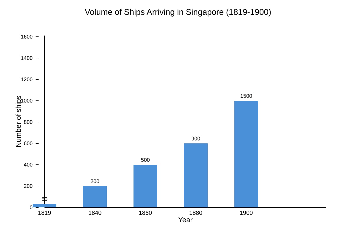
Answer: Number of ships increased steadily from 50 in 1819 to 1500 in 1900.
Marks: 3m for correct trend description.
Visual: Bar chart shows rising bars.
18. [4m]
Answer: Free port policy (Source A) attracted ships without taxes, causing growth shown in chart.
Marks: 2m link to source + 2m link to chart.
Teaching note: Connect source evidence to data.
Section C: Structured Response (20 marks)
19. [6m]
Reason 1: Opening of Suez Canal (1869) increased global trade flow to Singapore. [3m: 1 identify + 2 elaborate]
Reason 2: Demand from rubber/tin industries needed better port facilities. [3m: 1 identify + 2 elaborate]
Teaching note: External and economic factors; not just internal.
20. [14m]
Mark descriptors:
- Identify 3 external developments (e.g., Suez Canal, global trade expansion, WW2 context) [3m]
- Explain each with causal link to port growth (1819–1942) [9m: 3m each]
- Conclusion on overall impact [2m]
Sample:
- Suez Canal 1869: shortened route, more ships.
- Global trade: demand for tin/rubber from region.
- Regional stability/conflict: British rule provided order for trade.
Teaching note: Must show change over time, not just list.
End of Answer Key