From Real Exams Exam Paper
Secondary 1 History Semestral Assessment 2 (End of Year) Paper 1
Free Sec 1 History SA2 Paper 1, Kimi2.6 Exam version, with questions, answers, and syllabus-aligned practice for Singapore students.
These static practice materials are generated from the site's syllabus and paper-generation workflow, with source and model context shown so students and parents can evaluate the material before use.
Questions
TuitionGoWhere Exam Practice (AI) - SA2 History Secondary 1
TuitionGoWhere Secondary School (AI)
| Subject: | History |
| Level: | Secondary 1 (Express / G3) |
| Paper: | SA2 Practice Paper Version 1 of 5 |
| Duration: | 1 hour 15 minutes |
| Total Marks: | 60 |
| Name: | _________________________ |
| Class: | _________________________ |
| Date: | _________________________ |
INSTRUCTIONS TO CANDIDATES
- Write your name, class, and date in the spaces provided above.
- Answer ALL questions.
- Write your answers in the spaces provided. If you need more space, continue on the additional sheets provided.
- For source-based questions, use the sources provided and your own knowledge where appropriate.
- Marks are awarded for clear, well-organised answers supported by relevant historical evidence.
SECTION A: SOURCE-BASED SKILLS (25 marks)
Study the sources below and answer all the questions.
Source A
A sketch of a trading ship in the Melaka Strait, dated to the early 1500s. The ship carries woven fabrics, spices, and pottery from various ports.
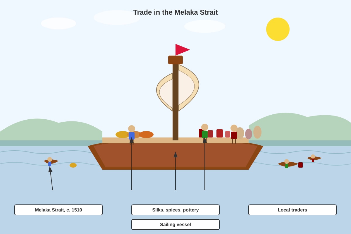
Generated source_image for Q1-3.
Source B
"Melaka was the most important port in our region. Traders from China, India, Arabia, and even Europe came to exchange their goods. The ruler made sure the port was safe, and taxes were fair. This is why our city grew rich."
— Adapted from the Sejarah Melayu (Malay Annals), a court chronicle written in the 1600s about the heyday of the Melaka Sultanate in the 1400s-1500s.
Source C
An extract from a Portuguese trader's journal, 1511:
"We arrived at Melaka and found a great city of trade, with people of many nations. Yet the local ruler was weak in defending his port. We took control of the city to protect our trade and to spread the Christian faith. The spice trade must not be left to others."
Source D
A modern historian's account, 2018:
"The fall of Melaka in 1511 marked a shift in Southeast Asian trade patterns. While European powers sought direct control of spices, local traders adapted by using alternative ports such as Johor and Bintan. The region's trading culture did not end; it transformed."
1(a) What can you learn from Source A about trade in the Melaka Strait? Use the source and your own knowledge to support your answer. (3 marks)
1(b) How useful is Source B as evidence about why Melaka became successful? Explain your answer. (4 marks)
1(c) Study Sources C and D. How similar are these sources about the fall of Melaka? (5 marks)
1(d) "European arrival in Southeast Asia brought only destruction to local trade." How far do the sources support this statement? Use the sources and your own knowledge. (8 marks)
[Turn over]
SECTION B: STRUCTURED RESPONSE — SINGAPORE'S DEVELOPMENT (20 marks)
2(a) Explain two reasons why Singapore was chosen as a trading post by the British in 1819. (4 marks)
2(b) The treaty that Raffles signed with the Temenggong and Sultan Hussein in 1819 allowed the British to set up a trading post. Explain why this agreement was important for the British and for the local rulers. (6 marks)
2(c) "The development of Singapore as a port was mainly due to its geographical location." How far do you agree with this statement? Explain your answer. (10 marks)
SECTION C: KNOWLEDGE AND UNDERSTANDING (15 marks)
3(a) Study the map below.
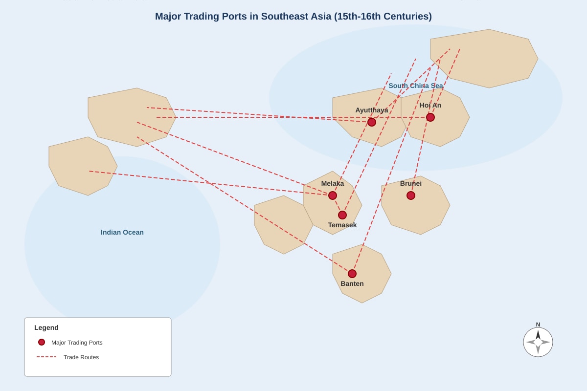
Generated map for Q3a.
What does the map suggest about Singapore's (Temasek's) position in regional trade networks before 1819? (2 marks)
3(b) Name one ancient civilisation that had contact with Southeast Asia through trade, and explain one effect of this contact. (3 marks)
3(c) Describe two ways in which the lives of people in Singapore changed under British colonial rule in the 1800s. (4 marks)
3(d) Explain why the British built a new harbour at Tanjong Pagar in the 1850s. (3 marks)
3(e) "The opening of the Suez Canal in 1869 was more important than the advent of steamships for Singapore's growth as a trading port." Do you agree? Explain your answer. (3 marks)
END OF PAPER
CHECK YOUR WORK BEFORE HANDING IN
TOTAL MARKS: 60
| Section | Marks |
|---|---|
| Section A (Source-Based) | 25 |
| Section B (Structured Response) | 20 |
| Section C (Knowledge and Understanding) | 15 |
| TOTAL | 60 |
Answers
TuitionGoWhere Exam Practice (AI) - SA2 History Secondary 1
ANSWER KEY VERSION 1 of 5
Total Marks: 60
SECTION A: SOURCE-BASED SKILLS (25 marks)
1(a) What can you learn from Source A about trade in the Melaka Strait? Use the source and your own knowledge to support your answer. (3 marks)
Answer framework:
| Mark Point | Explanation |
|---|---|
| L1: Identify explicit features (1-2 marks) | Identify at least two features from the source: variety of goods (silks, spices, pottery); presence of local traders; use of sailing ships; activity in the Melaka Strait |
| L2: Make inferences with own knowledge (2-3 marks) | Infer what this suggests about the nature of trade: long-distance trade connecting different regions; Southeast Asia as a hub for exchange; economic activity predating European control. Support with own knowledge: this was the "Age of Commerce" (1400s-1600s) when Southeast Asian ports connected Chinese, Indian, Arab, and later European traders. |
Sample answer structure for 3 marks:
- The source shows that the Melaka Strait was an active trading area before 1511, with ships carrying goods from across Asia [1 mark — explicit feature]
- The variety of goods (fabrics, spices, pottery) suggests that this was a multi-lateral trade network connecting producers and consumers from different regions [1 mark — inference]
- My own knowledge is that this period was known as the "Age of Commerce" when Southeast Asian ports like Melaka thrived as emporia where Chinese, Indian, and Arab merchants exchanged goods without direct European control, showing that Asian maritime trade was well-developed and sophisticated before European arrival [1 mark — own knowledge supporting inference]
Common mistake: Describing the source without explaining what it reveals about trade patterns or without using own knowledge.
1(b) How useful is Source B as evidence about why Melaka became successful? (4 marks)
Answer framework:
| Level | Marks | Requirements |
|---|---|---|
| L1 | 1-2 | Identify content about Melaka's success or identify provenance only |
| L2 | 2-3 | Explain usefulness based on content OR provenance with some detail |
| L3 | 3-4 | Evaluate both content AND provenance to reach a balanced judgement |
Key points to cover:
Content usefulness:
- Source B identifies specific reasons for Melaka's success: strategic position attracting traders from China, India, Arabia, and Europe; safe port conditions; fair taxation policy; effective governance by the ruler
- This matches historical evidence: Melaka's location on the Strait controlled the passage between Indian Ocean and South China Sea; the rulers did implement policies to attract traders, including warehouses, uniform weights/measures, and legal protection
Provenance considerations:
- Written in the 1600s about events of the 1400s-1500s — some temporal distance but within living memory of court traditions
- Sejarah Melayu (Malay Annals) was a court chronicle — written to glorify the Malay sultanate and establish legitimacy, so likely biased toward praising the rulers
- Purpose was to celebrate and preserve Malay royal traditions, not objective historical analysis
- Hence useful for understanding how the court wanted Melaka remembered, but less useful for balanced assessment of other factors (e.g., role of non-Malay communities, exact economic data)
Balanced judgement for 4 marks: Source B is useful for understanding the official Malay court perspective on why Melaka succeeded — the emphasis on ruler wisdom and fair policies reflects genuine administrative innovations. However, it is limited because its purpose is to celebrate and legitimise the sultanate rather than provide neutral analysis. It omits the contributions of Chinese, Indian, and Javanese trading communities who also shaped Melaka's success, and it exaggerates the ruler's role. Therefore, it is partially useful but must be cross-referenced with archaeological evidence and foreign accounts for a complete picture.
1(c) Study Sources C and D. How similar are these sources about the fall of Melaka? (5 marks)
Marking structure (AO2 — cross-referencing):
| Component | Marks | What to demonstrate |
|---|---|---|
| Identified similarities | 1-2 | At least two clear similarities in content, tone, or approach |
| Explained similarities with evidence | 2-3 | Explain what sources agree on, using direct reference to both |
| Evaluated degree of similarity | 1 | Assess whether they are entirely similar or have important differences too |
Similarities to identify:
-
Both acknowledge Melaka's significance: Source C calls it "a great city of trade"; Source D calls it a centre of trade patterns. Both recognise its economic importance before 1511.
-
Both discuss the fall/transition of 1511: Source C describes the Portuguese taking control; Source D describes "the fall of Melaka in 1511" as a turning point. Both identify this as a significant moment.
-
Both mention European actions: Source C's "we took control" and Source D's "European powers sought direct control" — both identify European agency in the change.
Important difference to note for full marks: The sources are partially similar in recognising the event's significance, but differ in perspective and implication. Source C is a Portuguese contemporary account justifying conquest (weakness of ruler, protection of trade, spread of Christianity — pro-imperial); Source D is a modern historian assessing long-term consequences with neutrality. Source C sees the fall as Portuguese triumph; Source D sees it as regional transformation. The similarity is in recognising significance, not in interpreting it.
Sample 5-mark answer: Sources C and D are similar in recognising that Melaka's fall in 1511 was historically significant. Source C describes it as "a great city of trade" whose control was worth seizing, while Source D identifies it as marking "a shift in Southeast Asian trade patterns" — both treat the event as important. They also similarly identify European agency: Source C's "we took control" and Source D's "European powers sought direct control" both place Europeans as active agents of change. However, the sources are not entirely similar. Source C is a Portuguese justification written at the time, presenting conquest as necessary due to local "weakness" and for religious purposes; its tone is self-justifying. Source D is a modern analytical assessment that focuses on adaptation and transformation rather than conquest. Therefore, the sources are similar in identifying the significance of 1511 but differ substantially in perspective, purpose, and interpretation. The similarity is limited to recognising the event's importance, not in evaluating its meaning.
1(d) "European arrival in Southeast Asia brought only destruction to local trade." How far do the sources support this statement? (8 marks)
Marking structure:
| Level | Marks | Requirements |
|---|---|---|
| L1 (Assertion) | 1-2 | Agree or disagree without using sources meaningfully |
| L2 (Source use) | 3-4 | Use sources to support or challenge; one-sided |
| L3 (Cross-reference + partial own knowledge) | 5-6 | Use sources on both sides; begin to bring in own knowledge; some evaluation of sources |
| L4 (Full evaluation + integrated own knowledge) | 7-8 | Balanced use of all sources; clear evaluation of provenance; well-selected own knowledge; reasoned judgement |
Arguments that sources SUPPORT the statement:
- Source C shows Portuguese military conquest — "we took control of the city" — demonstrating violent European takeover, disrupting existing political order
- Source C's reference to protecting "our trade" and spreading Christianity suggests European priorities replaced local commercial and religious autonomy
- Source A (contextual own knowledge) shows the pre-existing vibrant Asian trade network that was disrupted; Portuguese monopoly practices (cartaz system forcing ships to buy Portuguese passes) did constrain free trade
Arguments that sources CHALLENGE or LIMIT the statement:
- Source D explicitly states that "the region's trading culture did not end; it transformed" — local traders "adapted by using alternative ports" — showing continuity and resilience, not "only destruction"
- Source D's phrase "local traders adapted" shows agency and survival, not passive victimhood
- Source B (contextual own knowledge from earlier question) — the very existence of the Malay Annals as a preserved tradition shows cultural continuity; other ports like Johor, Riau, and Aceh flourished after 1511
- Own knowledge: Portuguese Melaka (1511-1641) actually continued as a trading port; the Dutch later took it and maintained its function; Singapore's 1819 foundation shows European powers continuing earlier trading patterns in new locations. British Singapore consciously emulated aspects of earlier Asian port systems.
Evaluation of sources for top marks:
- Source C is limited: written by a Portuguese with vested interest in justifying conquest; may exaggerate "weakness" of local ruler; written in 1511, immediately after event, with limited perspective on long-term consequences
- Source D is a modern historical assessment with broader temporal perspective; likely more balanced but may romanticise local "adaptation"
- Source A provides visual evidence of pre-European prosperity, allowing us to measure what was at stake
Judgement for 7-8 marks: The sources partially support the statement but strongly qualify it. Source C supports the view that European arrival involved violent conquest and displacement of local authority. However, Source D directly challenges "only destruction" by showing transformation and adaptation. The sources together suggest that while European military arrival caused disruption, local trading networks showed resilience and continuity. To say "only destruction" is an oversimplification that the sources themselves do not fully support. Own knowledge confirms this: while Portuguese control of Melaka did impose new monopolies, Asian traders rerouted through Johor, Aceh, and Banten, and later Singapore's free-port policy under the British actually expanded regional trade beyond pre-1511 levels by the 1800s.
SECTION B: STRUCTURED RESPONSE — SINGAPORE'S DEVELOPMENT (20 marks)
2(a) Explain two reasons why Singapore was chosen as a trading post by the British in 1819. (4 marks)
1 mark per reason identified; 1 mark per explanation (2 × 2 = 4 marks)
| Reason | Explanation |
|---|---|
| Geographical location / strategic position | Singapore lay at the southern tip of the Malay Peninsula, commanding the narrow Strait of Melaka through which most trade between China and India passed. This gave British ships a safe harbour on the route to China, especially for the growing tea and opium trade. Raffles specifically wanted to pre-empt Dutch control of the region's trade routes. |
| Natural harbour / deep water | Singapore's northern shore had deep, sheltered water suitable for large ocean-going ships to anchor safely, unlike many other nearby ports with shallow or exposed coasts. This was essential for the new generation of larger British trading vessels and naval ships. |
| Free from Dutch control | The Dutch dominated existing ports like Melaka and Batavia (Jakarta) with restrictive trading policies. Singapore offered an alternative where the British could establish a free port with no duties, attracting traders away from Dutch-controlled harbours. |
(Any two reasons with developed explanation — 2 marks each)
Teaching note: Students may also mention the local political situation (Temenggong and Sultan Hussein were disputing legitimacy, making them receptive to British alliance) — this is acceptable if explained.
2(b) The treaty that Raffles signed with the Temenggong and Sultan Hussein in 1819 allowed the British to set up a trading post. Explain why this agreement was important for the British and for the local rulers. (6 marks)
Marking: 3 marks for British side; 3 marks for local rulers' side. At least two developed points per side for full marks.
For the British:
| Point | Development |
|---|---|
| 1. Strategic foothold in Southeast Asia | The treaty gave Britain a legal base in a region where the Dutch were dominant. This was part of Britain's "forward movement" to protect routes to China and India, the core of their Asian empire. |
| 2. Free trade base | Unlike Dutch ports with tariffs and monopolies, Singapore was declared a free port from 1819, attracting regional and international trade. This generated commercial profits for British merchants and expanded British economic influence without military conquest costs. |
| 3. Naval and military station | Singapore could serve as a repair and supply point for Royal Navy ships patrolling against piracy and rival powers, extending British power projection. |
For the local rulers:
| Point | Development |
|---|---|
| 1. Recognition and legitimacy | Sultan Hussein was recognised as Sultan of Johor (disputed by the Dutch-backed claimant in Riau), giving him international standing he lacked. The treaty elevated his status through British acknowledgement. |
| 2. Protection and income | The Temenggong and Sultan received annual payments (5,000 Spanish dollars to Sultan; 3,000 to Temenggong initially), providing reliable revenue. They gained British protection against rivals, including the Dutch and other claimants to the Johor throne. |
| 3. Continued local authority | The treaty allowed local rulers to retain internal control over their people and religion while ceding only external relations and the port area to the British — a limited concession that preserved much of their authority. |
Common mistake: Treating the treaty as a simple colonial takeover. It was actually a mutual agreement where both sides saw advantages — the British got legal cover for their expansion; the local rulers got resources and recognition in a difficult political situation.
2(c) "The development of Singapore as a port was mainly due to its geographical location." How far do you agree with this statement? Explain your answer. (10 marks)
Marking structure (essay-style argument):
| Level | Marks | Requirements |
|---|---|---|
| L1 | 1-3 | Simple agreement or disagreement; limited reasons; little/no evidence |
| L2 | 4-6 | Two-sided argument with some evidence; may be unbalanced or lack evaluation |
| L3 | 7-8 | Balanced argument with clear evidence; begins to weigh factors; some evaluation of "mainly" |
| L4 | 9-10 | Sustained evaluation with explicit weighing; recognises interaction of factors; compelling judgement on "mainly" |
Arguments AGREEING (geography was main factor):
| Evidence | Explanation |
|---|---|
| 1. Location on Strait of Melaka | Singapore sat at the chokepoint between Indian Ocean and South China Sea — the route all ships between Europe/India and China/East Asia had to pass. No comparable alternative existed in the region. |
| 2. Natural harbour | Deep, sheltered waters on the north shore allowed ships of all sizes to anchor safely. The island had fresh water (important for ships) and was defensible. |
| 3. Equidistant positioning | Singapore was roughly equidistant from China and India, making it a natural halfway point for trade, rest, and resupply — location created function. |
Arguments DISAGREEING or identifying OTHER factors:
| Factor | Evidence | Explanation |
|---|---|---|
| 1. British free-port policy (human decision) | William Farquhar and later merchants insisted on zero customs duties | This policy choice, not geography, attracted traders away from Dutch ports. Geography made it possible; policy made it successful. |
| 2. Technological change (steamships) | After 1860s, steamships needed coal depots and regular servicing | Singapore's development accelerated due to steam technology — geography alone didn't cause this; British infrastructure investment did. |
| 3. Suez Canal (1869) | Egyptian canal shortened Europe-Asia route | This external event transformed Singapore's importance — not geography changing, but human engineering of the canal altered geographical significance. |
| 4. Political decisions of local rulers | Temenggong and Sultan Hussein's agreement | Without their willingness to sign the 1819 treaty, the location would have been unusable. Dutch Riau or other ports might have developed instead. |
Evaluation for top marks: Geography was necessary but not sufficient. Singapore's location provided the potential for development, but without British free-trade policy, steam technology, the Suez Canal, and local political cooperation, that potential would not have been realised. Other ports in similar locations (e.g., Karimun, nearby islands) did not develop because they lacked these complementary factors. The "main" cause depends on time period: geography was foundational in 1819, but policy and technology drove growth after 1860. A sophisticated answer recognises that geography created opportunity, while human decisions and historical contingencies realised that opportunity.
Synthesis for 9-10 marks: While geography provided the essential foundation that made Singapore possible, it was not the main driver of its actual development. The statement is too deterministic. British policy choices (free port, infrastructure investment), technological change (steam, Suez Canal), and the actions of local and regional actors transformed geographical potential into historical reality. The development was a combination in which geography was the platform, not the engine.
SECTION C: KNOWLEDGE AND UNDERSTANDING (15 marks)
3(a) What does the map suggest about Singapore's (Temasek's) position in regional trade networks before 1819? (2 marks)
Answer:
- Temasek/Singapore was connected to but not dominant in regional trade networks [1 mark — infer from map showing it as one node among several]
- It was part of a broader network centred on Melaka and other larger ports; it lay on routes connecting Southeast Asia to China and India but was not itself the main hub [1 mark — comparison with larger ports shown, recognition of subordinate role]
Teaching note: The map should show Temasek as a smaller port in a network where Melaka, Banten, Ayutthaya were larger. Students may note that Temasek's position at the tip of the Malay Peninsula gave it potential strategic value that was not fully realised until the British period.
3(b) Name one ancient civilisation that had contact with Southeast Asia through trade, and explain one effect of this contact. (3 marks)
| Civilisation | Effect of contact |
|---|---|
| China (Han/Tang/Song dynasties) | Spread of Confucian ideas and political models to Vietnam; Chinese demand for Southeast Asian spices, aromatics, and tropical woods drove trade; Chinese migration and intermarriage created Peranakan communities; tributary system incorporated some Southeast Asian states into Chinese diplomatic order [any one developed] |
| India (Mauryan/Gupta, South Indian kingdoms) | Spread of Hinduism and Buddhism to Southeast Asia, leading to state formation in Funan, Champa, and later Srivijaya and Majapahit; Sanskrit became language of temple inscriptions and courts; Indian architectural styles influenced temple construction (e.g., Borobudur, Angkor) [any one developed] |
| Arab/Persian traders | Introduction of Islam from 13th century, leading to conversion of Malacca and later regional sultanates; Arabic script adapted for Malay (Jawi); Islamic law and governance models adopted [any one developed] |
Marking: 1 mark for naming civilisation; 2 marks for explaining one effect with development (what changed, how, why it mattered).
3(c) Describe two ways in which the lives of people in Singapore changed under British colonial rule in the 1800s. (4 marks)
Two ways, 2 marks each (1 mark for identification, 1 mark for development/example):
| Way | Development / Example |
|---|---|
| 1. Economic transformation / new employment | Traditional fishing and subsistence agriculture declined for many; new jobs in port labour, shipping clerks, rickshaw pulling, and later rubber processing emerged. By 1900, Singapore was a major export centre for tin and rubber from the Malay Peninsula, creating a working class dependent on global commodity markets. |
| 2. Population growth and ethnic diversity | Singapore's population grew from about 1,000 in 1819 to over 300,000 by 1900. Chinese, Indian, and Arab immigrants arrived as labourers and traders, creating a plural society. This transformed a small Malay fishing village into a cosmopolitan but segregated colonial port city. |
| 3. Urban infrastructure and living conditions | New buildings, roads, and the 1850s harbour works changed the physical environment. However, overcrowded "coolie quarters" and lack of sanitation created health problems — cholera outbreaks in the 1850s-1870s. The Municipal government was established in 1887 to manage these urban issues. |
| 4. Education and cultural change | English-language schools established (Raffles Institution, 1823; St. Joseph's Institution, 1852); vernacular schools for Chinese and Indians followed. This created new social mobility paths but also cultural tensions between English-educated and traditional communities. |
(Any two ways with developed examples)
3(d) Explain why the British built a new harbour at Tanjong Pagar in the 1850s. (3 marks)
| Point | Explanation |
|---|---|
| 1. Existing port inadequate | The original Singapore River anchorage was becoming too small and congested for the growing volume of shipping, especially larger steamships that needed deeper water and quayside facilities for loading/unloading. |
| 2. Accommodating new technology | Steamships required coal bunkering facilities, repair docks, and direct wharf access rather than lighter transfer from anchored ships. Tanjong Pagar offered deeper water and space for these installations. |
| 3. Maintaining competitive position | Rival ports like Penang and Batavia were improving their facilities. To remain the region's premier port, Singapore needed modern harbour infrastructure. The New Harbour (later Keppel Harbour) opened in 1852 to ensure this commercial leadership. |
Marking: 1 mark per reason with brief explanation; all three for full 3 marks. Two well-developed points may also score 3.
3(e) "The opening of the Suez Canal in 1869 was more important than the advent of steamships for Singapore's growth as a trading port." Do you agree? Explain your answer. (3 marks)
This is a judgement question requiring balanced consideration.
| Position | Argument |
|---|---|
| Agree (Suez more important) | The canal dramatically shortened the Europe-Asia route (from months around Africa to weeks); it made Singapore the first major Asian port on the new direct route, funnelling all European trade through it; this structural change in global shipping routes was irreversible and transformative |
| Disagree (Steamships more important) | Steamships made the canal usable — sailing ships couldn't benefit as much from the shorter route because they depended on winds; steamships needed coaling stations (like Singapore), creating regular, scheduled services that built consistent trade volume; technology enabled the route change |
| Balanced judgement | Both were interdependent: the canal created the route opportunity, steamships made it commercially viable. The canal's importance was medium-term (transforming route structure); steamships' importance was operational (making regular, reliable trade possible). Neither alone would have produced the same growth. |
Marking: 1 mark for identifying one factor's importance; 1 mark for identifying the other factor's importance or interaction; 1 mark for reasoned judgement weighing their relative significance. Full marks require explicit comparison, not just listing both.
TOTAL MARKS: 60
| Section | Question | Marks |
|---|---|---|
| A | 1(a) | 3 |
| A | 1(b) | 4 |
| A | 1(c) | 5 |
| A | 1(d) | 8 |
| B | 2(a) | 4 |
| B | 2(b) | 6 |
| B | 2(c) | 10 |
| C | 3(a) | 2 |
| C | 3(b) | 3 |
| C | 3(c) | 4 |
| C | 3(d) | 3 |
| C | 3(e) | 3 |
| TOTAL | 60 |
End of Answer Key Version 1
Free quiz and exam paper access
Enter your details to view this paper
Your access is remembered on this device.