From Real Exams Quiz
Secondary 1 Geography Physical Geography Quiz
Free Sec 1 Geography Physical Geography quiz, Nemo3 Exam version, with questions, answers, and syllabus-aligned practice for Singapore students.
These static practice materials are generated from the site's syllabus and paper-generation workflow, with source and model context shown so students and parents can evaluate the material before use.
Questions
Secondary 1 Geography Quiz - Physical Geography
Name: ___________________________
Class: ___________________________
Date: ___________________________
Score: _____ / 40
Duration: 45 minutes
Total Marks: 40
Instructions:
- Answer all questions in the spaces provided.
- Write your answers clearly and legibly.
- For diagram-based questions, refer to the diagrams provided.
- The number of marks is given in brackets [ ] at the end of each question or part question.
Section A: Multiple Choice Questions (10 marks)
Questions 1 to 10 carry 1 mark each. Choose the correct answer and write the letter (A, B, C, or D) in the box provided.
-
Which of the following processes is responsible for the formation of clouds?
A. Evaporation
B. Condensation
C. Precipitation
D. Transpiration
Answer: ☐ [1] -
In the water cycle, water vapour changes into liquid water droplets during:
A. evaporation
B. condensation
C. precipitation
D. infiltration
Answer: ☐ [1] -
Which type of rainfall occurs when warm, moist air is forced to rise over a mountain range?
A. Convectional rainfall
B. Relief rainfall
C. Frontal rainfall
D. Cyclonic rainfall
Answer: ☐ [1] -
The process by which water seeps into the ground and moves through soil and rock layers is called:
A. surface runoff
B. infiltration
C. percolation
D. groundwater flow
Answer: ☐ [1] -
Which of the following is NOT a store of water in the water cycle?
A. Atmosphere
B. Oceans
C. Glaciers
D. Clouds
Answer: ☐ [1] -
Tropical rainforests are typically found between which latitudes?
A. 0° and 10° North and South of the Equator
B. 10° and 23.5° North and South of the Equator
C. 23.5° and 66.5° North and South of the Equator
D. 66.5° and 90° North and South of the Equator
Answer: ☐ [1] -
Which layer of the tropical rainforest receives the most sunlight?
A. Forest floor
B. Understorey
C. Canopy
D. Emergent layer
Answer: ☐ [1] -
Mangrove trees have prop roots and pneumatophores. What is the main function of pneumatophores?
A. To anchor the tree in soft mud
B. To absorb nutrients from the soil
C. To allow gas exchange in waterlogged soil
D. To store fresh water
Answer: ☐ [1] -
Which of the following best describes the climate of tropical rainforests?
A. Hot and dry with distinct seasons
B. Warm and wet with no distinct seasons
C. Cool and wet with four seasons
D. Hot and wet with distinct wet and dry seasons
Answer: ☐ [1] -
Deforestation in tropical rainforests leads to a decrease in:
A. surface runoff
B. soil erosion
C. interception of rainfall
D. atmospheric carbon dioxide
Answer: ☐ [1]
Section B: Structured Questions (18 marks)
Answer all questions in the spaces provided.
- The diagram below shows the water cycle.
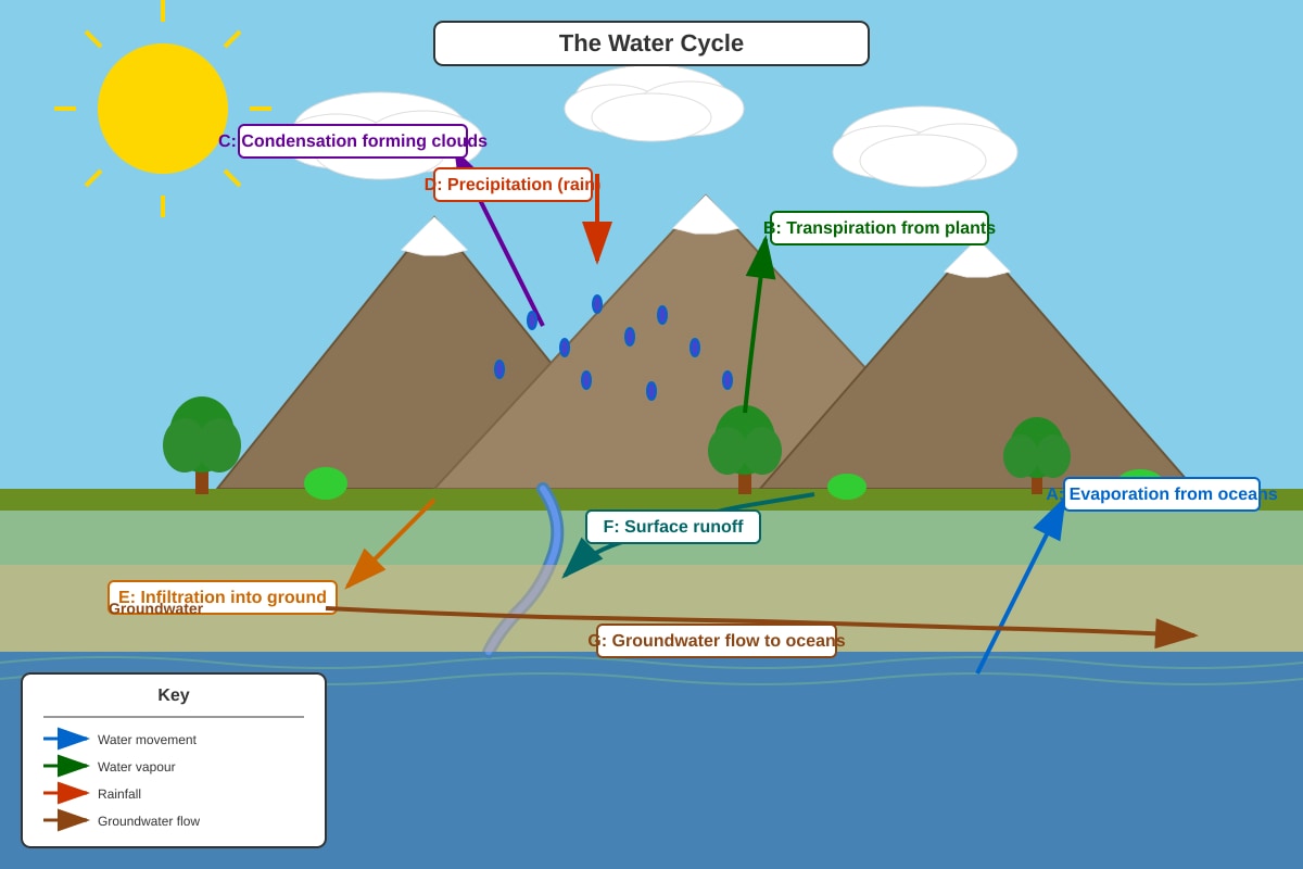
Generated diagram for Q11.
(a) Name the processes labelled A, C, and E in the diagram.
A: _______________________________________
C: _______________________________________
E: _______________________________________ [3]
(b) Explain how transpiration (labelled B) contributes to the water cycle.
______________________________________________________________________________ [2]
(c) State one difference between infiltration and percolation.
______________________________________________________________________________ [1]
- Study the climate graph for Singapore below.
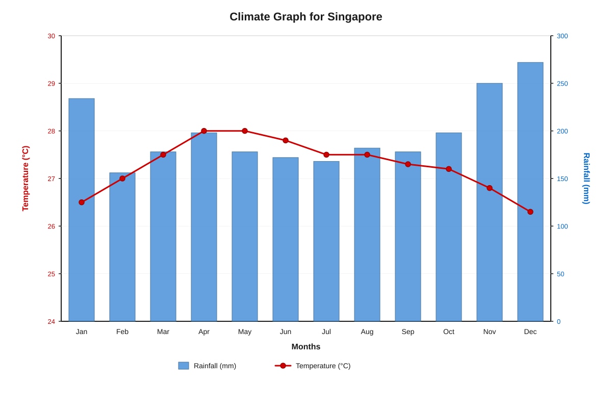
Generated graph for Q12.
(a) Describe the temperature pattern shown in the graph.
______________________________________________________________________________ [2]
(b) Describe the rainfall pattern shown in the graph.
______________________________________________________________________________ [2]
(c) Based on the graph, explain why Singapore experiences this type of climate.
______________________________________________________________________________ [2]
- The diagram below shows a cross-section of a tropical rainforest.
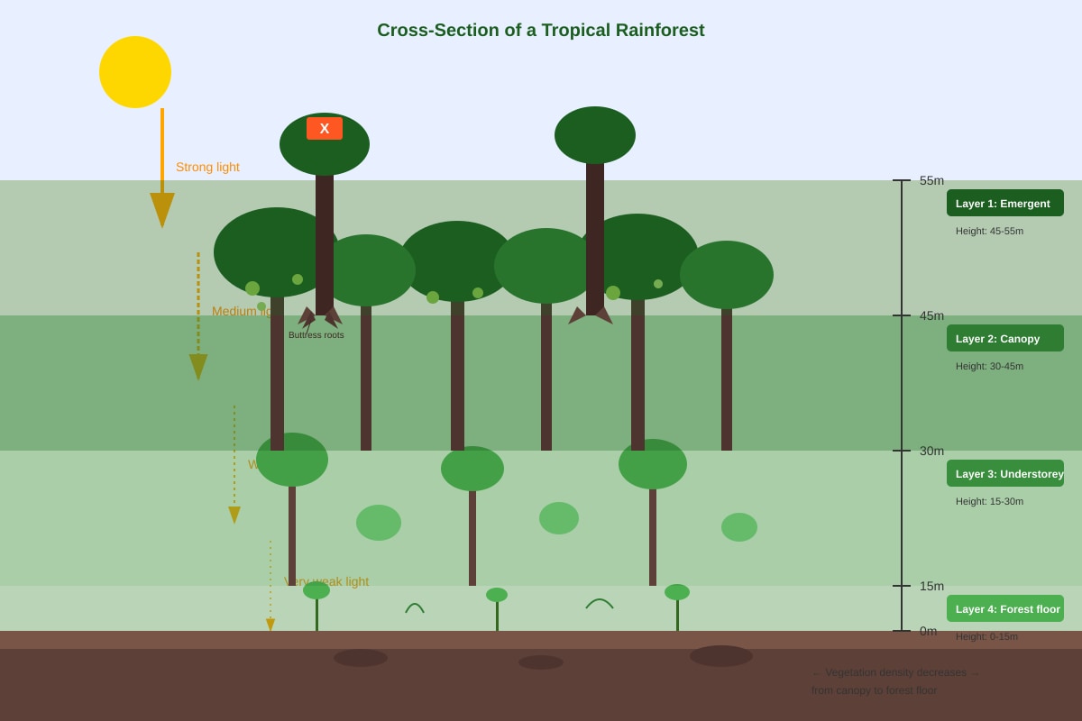
Generated diagram for Q13.
(a) Identify the layer labelled X (the topmost layer with the tallest trees).
______________________________________________________________________________ [1]
(b) State two characteristics of the vegetation in the canopy layer.
______________________________________________________________________________ [2]
(c) Explain why very little vegetation grows on the forest floor.
______________________________________________________________________________ [2]
- Mangrove forests are found along tropical coastlines.
(a) State two environmental conditions required for mangrove growth.
______________________________________________________________________________ [2]
(b) Explain how prop roots help mangrove trees survive in their environment.
______________________________________________________________________________ [2]
(c) Describe one way mangroves protect coastlines.
______________________________________________________________________________ [1]
- The table below shows the average monthly rainfall (mm) and temperature (°C) for a location in the Amazon rainforest.
| Month | Jan | Feb | Mar | Apr | May | Jun | Jul | Aug | Sep | Oct | Nov | Dec |
|---|---|---|---|---|---|---|---|---|---|---|---|---|
| Rainfall (mm) | 280 | 260 | 300 | 320 | 250 | 120 | 80 | 70 | 100 | 180 | 220 | 260 |
| Temperature (°C) | 27 | 27 | 27 | 27 | 26 | 26 | 26 | 27 | 27 | 27 | 27 | 27 |
(a) Calculate the annual rainfall for this location. Show your working.
Answer: _______________ mm [2]
(b) Identify the driest month and state its rainfall.
______________________________________________________________________________ [1]
(c) Calculate the annual temperature range.
Answer: _______________ °C [1]
(d) Based on the data, explain whether this location has a distinct dry season.
______________________________________________________________________________ [2]
Section C: Data Response and Extended Questions (12 marks)
Answer all questions in the spaces provided.
- Study the photograph below showing a deforested area in a tropical rainforest.
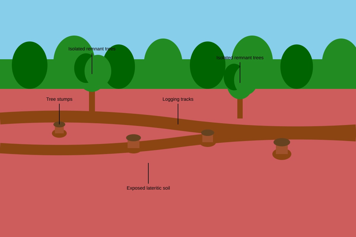
Generated source_image for Q16.
(a) Describe two visible impacts of deforestation shown in the photograph.
______________________________________________________________________________ [2]
(b) Explain how deforestation affects the water cycle in tropical rainforests.
______________________________________________________________________________ [3]
(c) Suggest one sustainable strategy to manage tropical rainforests. Explain how it helps.
______________________________________________________________________________ [2]
- The diagram below shows the formation of relief rainfall.
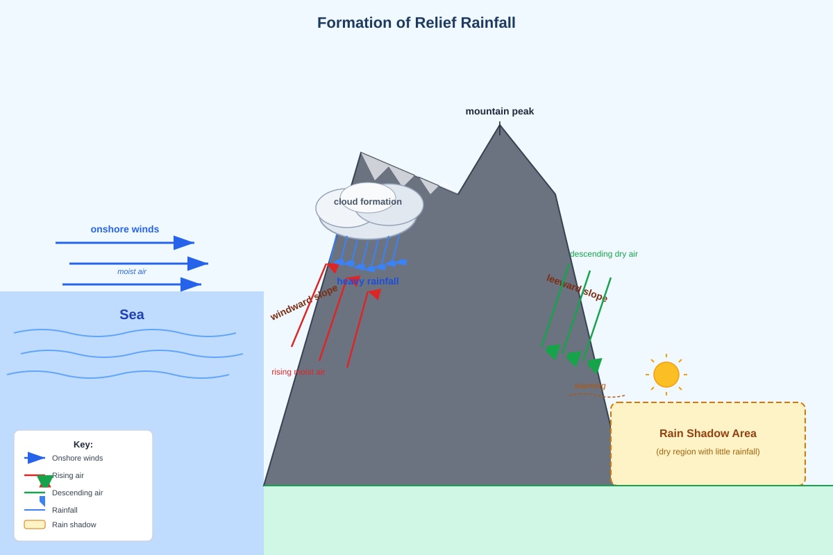
Generated diagram for Q17.
(a) On the diagram, label the windward side and leeward side of the mountain. [1]
(b) Explain why heavy rainfall occurs on the windward side of the mountain.
______________________________________________________________________________ [2]
(c) Explain why the leeward side experiences a rain shadow effect.
______________________________________________________________________________ [2]
- The diagram below shows the formation of convectional rainfall.
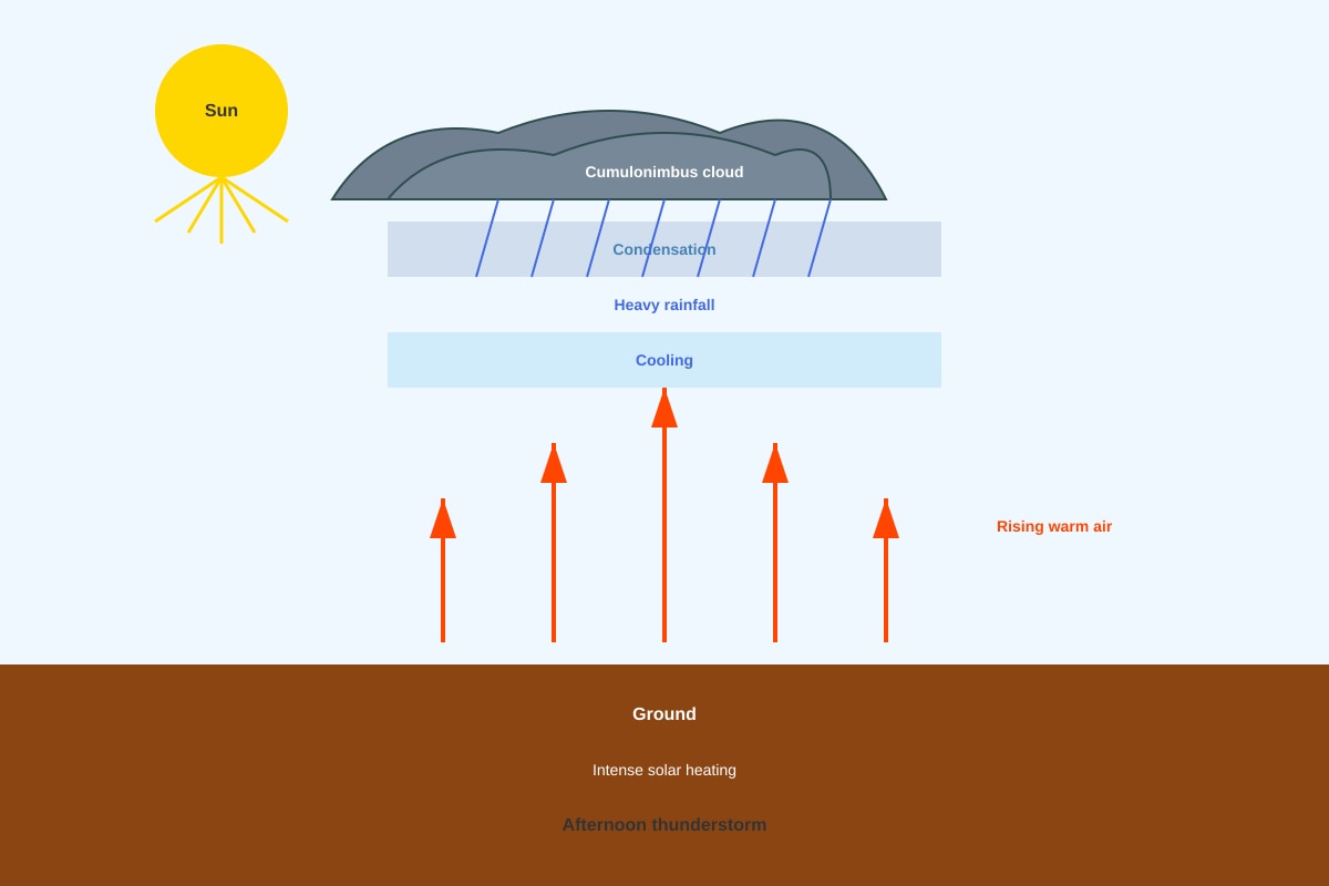
Generated diagram for Q18.
(a) Describe how convectional rainfall forms, using the diagram to help you.
______________________________________________________________________________ [3]
(b) State one difference between convectional rainfall and relief rainfall.
______________________________________________________________________________ [1]
- Explain two reasons why tropical rainforests have high biodiversity.
______________________________________________________________________________ [4]
- With reference to a named tropical rainforest, describe one threat it faces and explain one conservation strategy being used to protect it.
Named rainforest: _______________________________________
Threat: ______________________________________________________________________
Conservation strategy: _________________________________________________________
______________________________________________________________________________ [4]
Answers
Secondary 1 Geography Quiz - Physical Geography (Answer Key)
Total Marks: 40
Section A: Multiple Choice Questions (10 marks)
-
B [1]
Explanation: Condensation is the process where water vapour cools and changes into liquid water droplets, forming clouds. Evaporation (A) is liquid to gas, precipitation (C) is water falling from clouds, transpiration (D) is water release from plants. -
B [1]
Explanation: Condensation is the change of state from gas (water vapour) to liquid (water droplets). This occurs when warm, moist air rises and cools. -
B [1]
Explanation: Relief rainfall (orographic rainfall) occurs when moist air is forced to rise over a mountain barrier. As it rises, it cools, condenses, and forms rain on the windward side. -
C [1]
Explanation: Percolation is the downward movement of water through soil and rock layers. Infiltration (B) is entry of water into the soil surface. Surface runoff (A) is water flowing overland. Groundwater flow (D) is movement through aquifers. -
D [1]
Explanation: Clouds are not a store of water; they are a temporary transfer mechanism (condensed water vapour). The main stores are oceans (97%), ice caps/glaciers, groundwater, atmosphere (as vapour), lakes, and soil moisture. -
A [1]
Explanation: Tropical rainforests are typically found between 0° and 10° (sometimes up to 23.5°) North and South of the Equator, where it is hot and wet year-round. -
D [1]
Explanation: The emergent layer consists of the tallest trees (45-55m) that rise above the canopy, receiving the most direct sunlight. The canopy (C) receives filtered light; understorey (B) and forest floor (A) receive very little. -
C [1]
Explanation: Pneumatophores are specialised aerial roots that grow upwards out of waterlogged soil, allowing gas exchange (oxygen intake) for the submerged root system. Prop roots (A) provide anchorage. -
B [1]
Explanation: Tropical rainforests have high temperatures (25-27°C) and high rainfall (2000+ mm annually) with no distinct seasons—consistently warm and wet throughout the year. -
C [1]
Explanation: Deforestation removes the tree canopy, reducing interception (the capture of rainfall by leaves). This increases surface runoff (A) and soil erosion (B), and increases atmospheric CO₂ (D) due to reduced photosynthesis and decomposition.
Section B: Structured Questions (18 marks)
Question 11 [6 marks]
(a) [3 marks]
- A: Evaporation (from oceans/water bodies)
- C: Condensation (forming clouds)
- E: Infiltration (water entering the ground)
1 mark each. Accept "transpiration" for B if asked, but question asks for A, C, E only.
(b) [2 marks]
Transpiration is the release of water vapour from plant leaves through stomata. It contributes to the water cycle by:
- Adding water vapour to the atmosphere (1 mark)
- Which then condenses to form clouds and leads to precipitation (1 mark)
Key concept: Plants are a major source of atmospheric moisture, especially in rainforests.
(c) [1 mark]
Infiltration is the entry of water into the soil surface; percolation is the downward movement of water through soil and rock layers below the surface.
Common mistake: Confusing the two terms or saying they are the same.
Question 12 [6 marks]
(a) [2 marks]
- Temperature is consistently high throughout the year, ranging from 26°C to 28°C. (1 mark)
- There is no distinct seasonal variation / very small annual range (~2°C). (1 mark)
(b) [2 marks]
- Rainfall is high in all months (150-250 mm), with no dry month. (1 mark)
- Rainfall is fairly evenly distributed / shows two peaks (e.g., April and November) but no month receives very low rainfall. (1 mark)
(c) [2 marks]
Singapore is located near the Equator (1°N), so it:
- Receives direct overhead sun year-round → consistently high temperatures. (1 mark)
- Experiences convectional rainfall daily due to intense heating → high rainfall every month with no dry season. (1 mark)
Question 13 [5 marks]
(a) [1 mark]
Emergent layer (or "emergents")
(b) [2 marks]
Any two of:
- Forms a continuous dense canopy 30-45m high, blocking most sunlight.
- Trees have broad, waxy leaves with drip tips to shed water.
- Many epiphytes (orchids, ferns) and lianas (vines) grow on branches to reach light.
- Trees have shallow root systems with buttress roots for support in thin soil.
1 mark each.
(c) [2 marks]
- The dense canopy blocks 95-99% of sunlight from reaching the forest floor. (1 mark)
- Without sufficient light, photosynthesis is limited, so only shade-tolerant plants (ferns, mosses, seedlings) survive. (1 mark)
Key concept: Light is the limiting factor on the forest floor.
Question 14 [5 marks]
(a) [2 marks]
Any two of:
- Tropical latitudes (warm temperatures year-round, 20-30°C)
- Sheltered coastlines (estuaries, lagoons, bays) with low wave energy
- Intertidal zone with regular tidal flooding (brackish water)
- Fine, waterlogged, anaerobic mud (silt/clay) for root anchorage
- High rainfall / freshwater input from rivers reducing salinity
1 mark each.
(b) [2 marks]
Prop roots are arched roots growing from the trunk/stem into the mud. They:
- Provide structural support in soft, unstable, waterlogged soil (1 mark)
- Have lenticels (pores) allowing gas exchange for the root system (1 mark)
Both functions are essential for survival in anaerobic mud.
(c) [1 mark]
Mangroves protect coastlines by:
- Dissipating wave energy with their dense root systems, reducing coastal erosion.
OR Trapping sediment with roots, building up land and stabilising the shore.
OR Acting as a buffer against storm surges and tsunamis.
Any one valid point.
Question 15 [6 marks]
(a) [2 marks]
Working:
Annual rainfall = Sum of all monthly rainfall
= 280 + 260 + 300 + 320 + 250 + 120 + 80 + 70 + 100 + 180 + 220 + 260
= 2,440 mm
1 mark for correct working/sum, 1 mark for correct answer with unit.
(b) [1 mark]
August (or July) — 70 mm (or 80 mm for July)
Accept either July or August as driest; must state month and value.
(c) [1 mark]
Annual temperature range = Highest monthly temp – Lowest monthly temp
= 27°C – 26°C = 1°C
Small range typical of equatorial climates.
(d) [2 marks]
Yes, there is a distinct dry season. (1 mark for identification)
Evidence: Rainfall drops sharply from May (250 mm) to July (80 mm) and August (70 mm) — well below 100 mm — before rising again in September (100 mm). These 2-3 months form a noticeable drier period compared to the wetter months (250-320 mm). (1 mark for data-supported explanation)
Note: Unlike Singapore (no dry month < 150 mm), this Amazon location shows seasonality.
Section C: Data Response and Extended Questions (12 marks)
Question 16 [7 marks]
(a) [2 marks]
Any two visible impacts:
- Tree stumps / cleared land where forest once stood
- Exposed bare soil (red lateritic soil) with no vegetation cover
- Logging tracks / machinery paths cutting through the area
- Isolated remnant trees left standing (selective logging evidence)
- Soil erosion gullies may be visible on exposed slopes
1 mark each. Must be based on photograph evidence.
(b) [3 marks]
Deforestation affects the water cycle by:
- Reduced interception → less rainfall caught by canopy → more direct throughfall hitting soil (1 mark)
- Reduced transpiration → less water vapour returned to atmosphere → less cloud formation and local rainfall (1 mark)
- Reduced infiltration (due to soil compaction) → increased surface runoff and soil erosion (1 mark)
Key concept: Forests act as a "sponge" regulating water flow; removal disrupts the local and regional water cycle.
(c) [2 marks]
Strategy: Selective logging / Reduced-impact logging / Sustainable forest management / Ecotourism / Protected areas / National parks / Agroforestry / Reforestation
Explanation (1 mark):
- Selective logging: Only mature trees are harvested, allowing forest to regenerate naturally.
- Ecotourism: Provides income without destroying forest; incentivises conservation.
- Protected areas: Legal protection prevents logging/mining; preserves biodiversity.
- Agroforestry: Integrates trees with crops; maintains forest cover while supporting livelihoods.
Any valid strategy with clear explanation of how it helps.
Question 17 [5 marks]
(a) [1 mark]
Windward side = side facing the onshore wind (where air rises)
Leeward side = side sheltered from the wind (where air descends)
Must be correctly labelled on diagram. 1 mark for both correct.
(b) [2 marks]
- Moist onshore winds are forced to rise over the mountain barrier. (1 mark)
- As air rises, it expands and cools → water vapour condenses → forms clouds → heavy rainfall on windward slopes. (1 mark)
Key terms: forced ascent, adiabatic cooling, condensation, precipitation.
(c) [2 marks]
- Air descends on the leeward side → compresses and warms adiabatically. (1 mark)
- Warm air holds more moisture → relative humidity drops → clouds evaporate → little or no rain (rain shadow). (1 mark)
Key concept: Descending air warms and dries, creating arid conditions.
Question 18 [4 marks]
(a) [3 marks]
- Intense solar heating of the ground during the day warms the air above it. (1 mark)
- Warm air becomes less dense and rises rapidly (convection currents). (1 mark)
- As it rises, it cools → water vapour condenses → forms towering cumulonimbus clouds → heavy afternoon thunderstorms. (1 mark)
Must mention: heating, rising, cooling, condensation, cloud type, rainfall timing.
(b) [1 mark]
Convectional rainfall is caused by local heating of the ground (thermal convection), while relief rainfall is caused by air being forced to rise over a physical barrier (mountains).
OR Convectional rainfall occurs inland/equatorial regions (afternoon); relief rainfall occurs on windward coasts/mountains.
Any one clear difference.
Question 19 [4 marks]
Reason 1: Stable, favourable climate year-round [2 marks]
- Consistently high temperatures (25-27°C) and abundant rainfall (2000+ mm) allow continuous growth and reproduction — no dormant season. (1 mark)
- This supports complex food webs and specialised niches for countless species. (1 mark)
Reason 2: Complex vertical structure (stratification) [2 marks]
- Four distinct layers (emergent, canopy, understorey, forest floor) create multiple habitats with different light, humidity, and temperature conditions. (1 mark)
- Each layer supports specialised communities of plants and animals (e.g., epiphytes in canopy, shade-tolerant plants on floor), multiplying niches. (1 mark)
Other valid reasons: High primary productivity, evolutionary history/stability, complex species interactions (mutualism, pollination), large geographic area.
Question 20 [4 marks]
Named rainforest: Amazon Rainforest (or Congo Basin, Borneo, etc.)
1 mark for correct named example.
Threat: Deforestation for cattle ranching / soy farming / logging / mining / infrastructure (roads, dams)
Explanation: Large-scale clearing destroys habitat, fragments forest, releases carbon, displaces indigenous peoples.
1 mark for specific threat with brief explanation.
Conservation strategy: Protected areas / Indigenous reserves / Sustainable forest management / REDD+ (Reducing Emissions from Deforestation and Forest Degradation) / Ecotourism / Reforestation / International agreements (e.g., Amazon Cooperation Treaty)
Explanation:
- Protected areas/Indigenous reserves: Legal protection + indigenous stewardship effectively reduce deforestation rates.
- REDD+: Financial incentives for countries to keep forests standing (carbon credits).
- Sustainable management: Certification (FSC) ensures timber is harvested responsibly.
1 mark for valid strategy with clear explanation of how it protects the rainforest.
Marking Notes for Teachers
- Total: 40 marks — Section A (10), Section B (18), Section C (12).
- Section A: 1 mark each, no half marks.
- Section B & C: Award marks for key geographical terms (e.g., "adiabatic cooling", "interception", "stratification", "rain shadow", "biodiversity").
- Question 15(d): Accept "No distinct dry season" only if student argues all months > 100mm — but data shows July/Aug < 100mm, so "Yes" is correct. Award marks for data use.
- Question 19: Two distinct reasons required. Do not double-credit similar points (e.g., "high rainfall" and "high temperature" = one reason: climate).
- Question 20: Must name a specific rainforest. Generic "tropical rainforest" = 0 for name. Strategy must match threat (e.g., protected areas counter logging).
- Diagram questions (11, 13, 17, 18): If diagram not printed, accept answers based on description.
- Spelling: Accept phonetic spelling for key terms (e.g., "condensasion", "transperation") if meaning is clear.
- Units: Deduct 0.5 marks (or deny 1 mark) if units missing in calculations (Q15a, c).
Free quiz and exam paper access
Enter your details to view this paper
Your access is remembered on this device.