From Real Exams Exam Paper
Secondary 1 Geography Semestral Assessment 2 (End of Year) Paper 3
Free Sec 1 Geography SA2 Paper 3, Exam version, with questions, answers, and syllabus-aligned practice for Singapore students.
These static practice materials are generated from the site's syllabus and paper-generation workflow, with source and model context shown so students and parents can evaluate the material before use.
Questions
TuitionGoWhere Practice Paper - Geography Secondary 1
TuitionGoWhere Secondary School (AI)
Subject: Geography
Level: Secondary 1
Paper: SA2 (Version 3)
Duration: 1 hour 30 minutes
Total Marks: 65 marks
Name: ___________________
Class: ___________________
Date: ___________________
Instructions
- This paper consists of THREE sections.
- Answer ALL questions.
- Write your answers in the spaces provided.
- All diagrams are not drawn to scale unless otherwise stated.
- You may use a calculator where appropriate.
Section A: Map Skills and Data Interpretation [25 marks]
Study Figure 1, which shows a topographic map of Sentosa Island, and answer Questions 1-8.
Question 1 [1 mark]
State the 4-figure grid reference of Fort Siloso.
Answer: ___________________
Question 2 [1 mark]
What is the contour interval shown on this map?
Answer: ___________________
Question 3 [2 marks]
Give the 6-figure grid reference of the highest point on Sentosa Island.
Answer: ___________________
Question 4 [3 marks]
Describe the relief of the area between grid squares 2563 and 2664.
Study Figure 2, which shows water quality data collected by students at Marina Reservoir, and answer Questions 5-8.
| Site | Location | Temperature (°C) | pH Level | Dissolved Oxygen (mg/L) | Turbidity (NTU) |
|---|---|---|---|---|---|
| A | Near Marina Barrage | 28.5 | 7.2 | 8.4 | 12 |
| B | Central reservoir | 29.1 | 7.0 | 7.8 | 18 |
| C | Near Gardens by the Bay | 30.2 | 6.8 | 6.9 | 25 |
Question 5 [2 marks]
Which site has the best water quality? Use evidence from Figure 2 to support your answer.
Site: ___________________
Evidence: _______________________________________________________________
Question 6 [3 marks]
Describe the pattern of water temperature shown in the data.
Question 7 [2 marks]
Explain one reason why Site C has higher turbidity than Site A.
Question 8 [3 marks]
A student concluded that "water quality decreases as you move away from the Marina Barrage." Use evidence from Figure 2 to evaluate this conclusion.
Study Figure 3, which shows Singapore's daily water consumption from 2000 to 2020, and answer Questions 9-10.
Question 9 [4 marks]
With reference to Figure 3, describe the changes in Singapore's daily water consumption per person from 2000 to 2020.
Question 10 [4 marks]
Suggest two reasons for the trend shown in Figure 3.
Reason 1: ___________________________________________________________
Reason 2: ___________________________________________________________
Section B: Water Resources and Management [20 marks]
Question 11 [3 marks]
Describe three ways people use water in their daily lives.
Way 1: ______________________________________________________________
Way 2: ______________________________________________________________
Way 3: ______________________________________________________________
Question 12 [2 marks]
Describe one use of water for industries.
Question 13 [2 marks]
Is water a renewable or non-renewable resource? Explain your answer.
Classification: _______________________________________________________
Explanation: ________________________________________________________
Question 14 [4 marks]
Use evidence from Figure 4 to describe the pattern of how water is used globally.
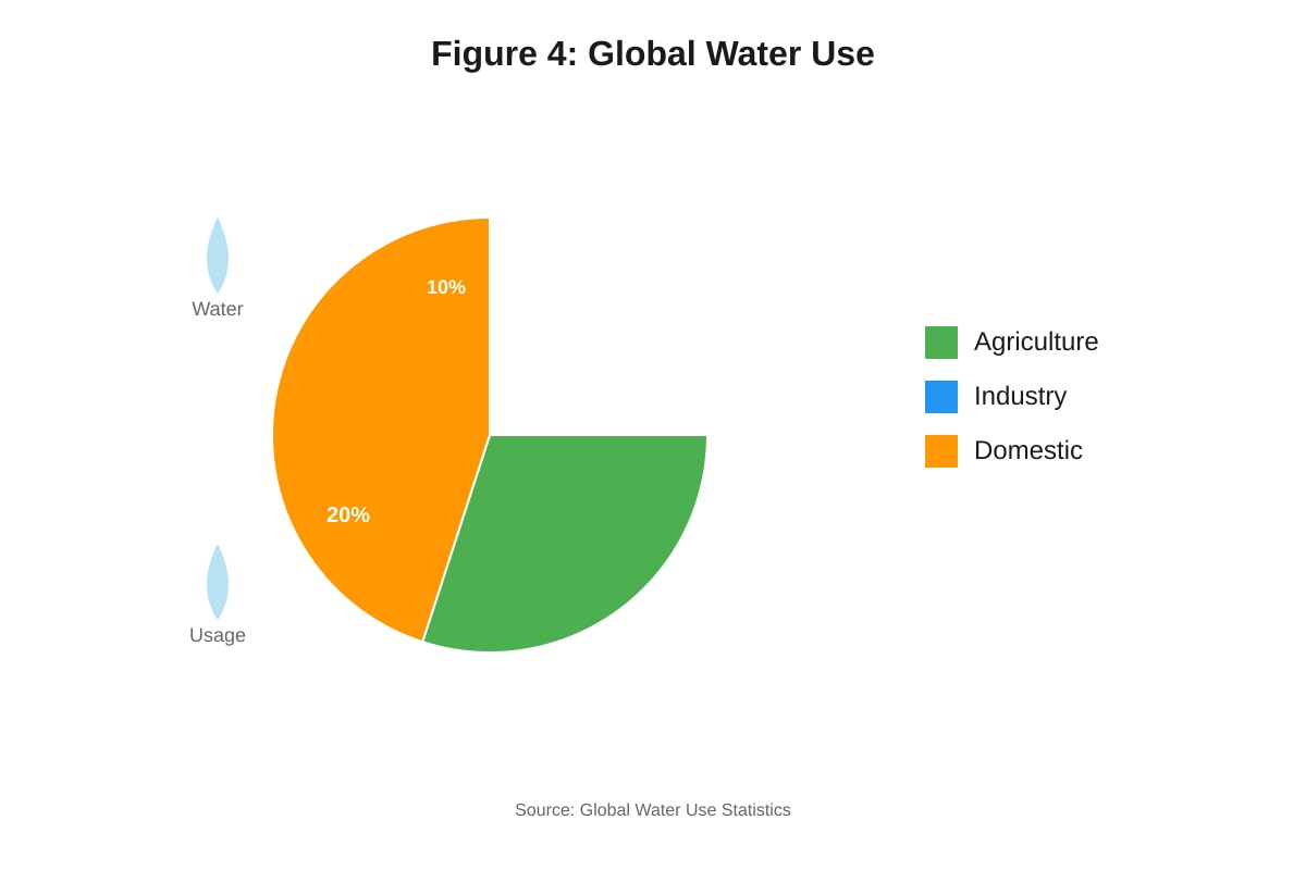
Generated figure for this question.
Question 15 [5 marks]
Singapore has developed the "Four National Taps" strategy to ensure water security. Explain how two of these strategies help Singapore manage its water resources sustainably.
Strategy 1: _________________________________________________________
Explanation: ________________________________________________________
Strategy 2: _________________________________________________________
Explanation: ________________________________________________________
Question 16 [4 marks]
Explain the strengths and limitations of water conservation campaigns as a strategy to manage water resources sustainably.
Strengths: __________________________________________________________
Limitations: ________________________________________________________
Section C: Coastal Environments and Sustainability [20 marks]
Question 17 [3 marks]
Describe how mangroves help to prevent coastal erosion.
Question 18 [2 marks]
Explain how the roots of mangrove plants adapt to the coastal environment.
Question 19 [3 marks]
Describe the distribution of mangroves in Singapore as shown in Figure 5.
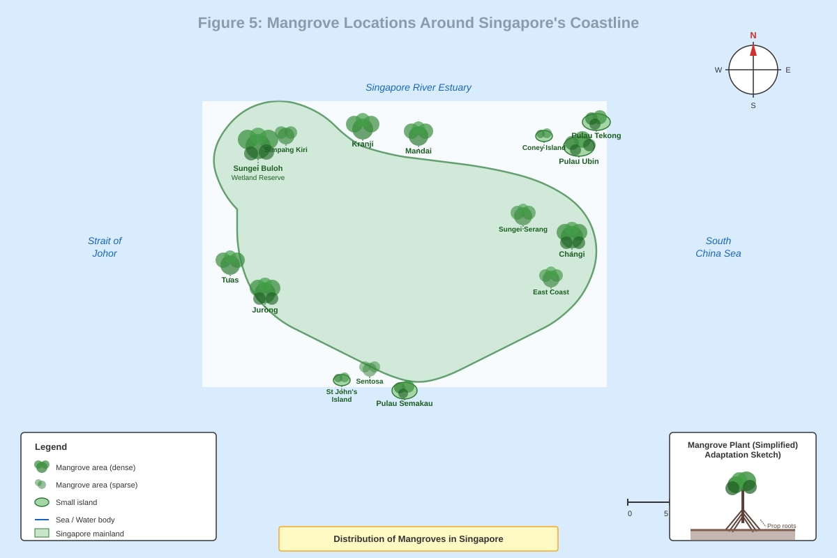
Generated figure for this question.
Question 20 [4 marks]
Explain why mangrove forests are usually found in sheltered environments such as river mouths and protected bays.
Question 21 [4 marks]
Evaluate the effectiveness of establishing nature reserves as a strategy to sustainably manage mangrove ecosystems.
Strengths: __________________________________________________________
Limitations: ________________________________________________________
Question 22 [4 marks]
A developer wants to clear a mangrove area to build a new shopping mall. Assess the environmental and economic impacts of this proposal.
Environmental impacts: _______________________________________________
Economic impacts: ___________________________________________________
END OF PAPER
Answers
TuitionGoWhere Practice Paper - Geography Secondary 1 (Answer Key)
SA2 Version 3 - Marking Scheme
Section A: Map Skills and Data Interpretation [25 marks]
Question 1 [1 mark]
Answer: 2563
- Accept any reasonable 4-figure grid reference for Fort Siloso location
- Deduct 1 mark if 6-figure reference given instead
Question 2 [1 mark]
Answer: 10m / 10 metres
- Accept "10" if units are clear from context
- Do not accept other intervals without justification
Question 3 [2 marks]
Answer: 256638 (or similar 6-figure reference for highest point)
- 2 marks for correct 6-figure reference
- 1 mark for correct 4-figure reference (2563)
- 0 marks for incorrect grid reference
Question 4 [3 marks]
Sample Answer: The relief shows gently sloping terrain / low-lying land (1 mark). The area rises gradually from sea level to approximately 50-60 metres (1 mark). The contour lines are widely spaced, indicating gentle gradients / slopes (1 mark).
Mark Scheme:
- 1 mark for describing general relief character
- 1 mark for height reference with evidence
- 1 mark for gradient/slope description with evidence
Question 5 [2 marks]
Answer: Site A Evidence: Site A has the highest dissolved oxygen (8.4 mg/L) and lowest turbidity (12 NTU), indicating better water quality.
Mark Scheme:
- 1 mark for identifying Site A
- 1 mark for appropriate evidence from the data
Question 6 [3 marks]
Sample Answer: Water temperature increases from Site A to Site C (1 mark). Site A has the lowest temperature at 28.5°C while Site C has the highest at 30.2°C (1 mark). The temperature rises by 1.7°C across the three sites (1 mark).
Mark Scheme:
- 1 mark for identifying the trend (increasing)
- 1 mark for using specific data values
- 1 mark for quantifying the change
Question 7 [2 marks]
Sample Answer: Site C is located near Gardens by the Bay where there may be more human activities / construction work (1 mark), which increases the amount of suspended particles in the water, making it more turbid (1 mark).
Mark Scheme:
- 1 mark for identifying a relevant cause
- 1 mark for explaining the link to turbidity
Question 8 [3 marks]
Sample Answer: The conclusion is partially supported by the data (1 mark). Dissolved oxygen decreases from 8.4 mg/L at Site A to 6.9 mg/L at Site C, and turbidity increases from 12 NTU to 25 NTU (1 mark). However, pH levels show only a small decrease and temperature increases, which may not necessarily indicate poorer water quality (1 mark).
Mark Scheme:
- 1 mark for evaluation statement
- 1 mark for supporting evidence
- 1 mark for qualifying/limiting evidence
Question 9 [4 marks]
Sample Answer: Singapore's daily water consumption per person decreased from 165 litres in 2000 to 141 litres in 2020 (1 mark). This represents a reduction of 24 litres per person per day (1 mark). The decrease was most significant between 2000 and 2010, falling by approximately 20 litres (1 mark). From 2010 to 2020, the consumption continued to decline but at a slower rate (1 mark).
Mark Scheme:
- 1 mark for overall trend with data
- 1 mark for quantifying total change
- 1 mark for describing period of greatest change
- 1 mark for describing rate of change over time
Question 10 [4 marks]
Sample Answers:
- Reason 1: Government water conservation campaigns educated people about water saving, leading to more efficient water use habits (2 marks)
- Reason 2: Introduction of water-efficient appliances and technologies reduced household water consumption (2 marks)
Mark Scheme:
- 2 marks per reason for clear explanation
- 1 mark per reason for basic identification only
Section B: Water Resources and Management [20 marks]
Question 11 [3 marks]
Sample Answers:
- Way 1: Domestic use - Water is used for household activities such as showering, washing dishes, and cleaning
- Way 2: Drinking and cooking - Water is essential for human consumption and food preparation
- Way 3: Recreation - Water is used for swimming pools, water sports, and leisure activities
Mark Scheme:
- 1 mark per way, must include description not just identification
- Accept: domestic, recreational, personal hygiene, gardening
Question 12 [2 marks]
Sample Answer: Water is used for cooling equipment in factories and power plants (1 mark) because industrial processes generate heat that needs to be removed to prevent damage to machinery (1 mark).
Mark Scheme:
- 1 mark for identifying industrial use
- 1 mark for explaining the purpose/process
Question 13 [2 marks]
Answer: Renewable Explanation: Water is replenished naturally through the hydrological cycle processes such as evaporation, condensation, and precipitation.
Mark Scheme:
- 1 mark for correct classification
- 1 mark for explanation referencing hydrological cycle
Question 14 [4 marks]
Sample Answer: Agriculture dominates global water use, accounting for 70% of total consumption (1 mark). Industry is the second largest user at 20% (1 mark). Domestic use accounts for only 10% of global water consumption (1 mark). This pattern shows that food production requires significantly more water than other human activities (1 mark).
Mark Scheme:
- 1 mark per sector with correct percentage
- 1 mark for interpretation/explanation of pattern
Question 15 [5 marks]
Sample Answers:
- Strategy 1: NEWater - Recycled wastewater provides a sustainable water source (1 mark) by treating used water to potable standards, reducing dependence on imports and natural sources (1.5 marks)
- Strategy 2: Desalination - Converting seawater to freshwater (1 mark) provides a weather-independent water source that can meet growing demand sustainably (1.5 marks)
Mark Scheme:
- 1 mark for identifying each strategy
- 1.5 marks for explaining how each contributes to sustainability
Question 16 [4 marks]
Sample Answer: Strengths: Water conservation campaigns raise public awareness about water scarcity and encourage behavioral changes that reduce consumption (2 marks). Limitations: Campaigns rely on voluntary participation and may not achieve significant water savings if people do not change their habits permanently (2 marks).
Mark Scheme:
- 2 marks for explaining strengths
- 2 marks for explaining limitations
Section C: Coastal Environments and Sustainability [20 marks]
Question 17 [3 marks]
Sample Answer: Mangrove roots form dense networks that trap and stabilize loose sediments (1 mark). The trapped sediments accumulate over time, building up the coastal area (1 mark). The root systems also reduce wave energy and water flow, preventing erosion of the coastline (1 mark).
Mark Scheme:
- 1 mark for sediment trapping function
- 1 mark for sediment accumulation/deposition
- 1 mark for wave energy reduction
Question 18 [2 marks]
Sample Answer: Mangrove roots include aerial/prop roots that extend above water (1 mark) to absorb oxygen from the air since the waterlogged soil lacks oxygen (1 mark).
Mark Scheme:
- 1 mark for identifying aerial/prop root adaptation
- 1 mark for explaining the environmental challenge addressed
Question 19 [3 marks]
Sample Answer: Mangroves are found along Singapore's coastlines, particularly on the northern and western shores (1 mark). They are also present on offshore islands such as Pulau Ubin and around Chek Jawa (1 mark). The distribution follows sheltered coastal areas and river mouths where conditions are suitable for growth (1 mark).
Mark Scheme:
- 1 mark for coastal distribution
- 1 mark for island locations
- 1 mark for environmental pattern recognition
Question 20 [4 marks]
Sample Answer: Mangrove seedlings need calm water conditions to establish and take root (1 mark). Strong waves and currents in exposed areas would uproot young plants before they can develop (1 mark). Sheltered environments like river mouths provide protection from wave action (1 mark) and often have brackish water conditions that mangroves prefer (1 mark).
Mark Scheme:
- 1 mark for seedling establishment requirement
- 1 mark for explaining wave damage risk
- 1 mark for identifying shelter benefit
- 1 mark for additional environmental factor
Question 21 [4 marks]
Sample Answer: Strengths: Nature reserves provide legal protection that prevents development and human interference (1 mark), allowing mangrove ecosystems to function naturally and maintain biodiversity (1 mark). Limitations: Reserves require ongoing funding for management and monitoring (1 mark), and may not address external threats like pollution from surrounding areas (1 mark).
Mark Scheme:
- 2 marks for explaining strengths with examples
- 2 marks for explaining limitations with examples
Question 22 [4 marks]
Sample Answer: Environmental impacts: Loss of mangrove habitat would reduce biodiversity and eliminate coastal protection services (1 mark), increasing erosion risk and removing carbon storage capacity (1 mark). Economic impacts: Short-term economic benefits from the shopping mall development and job creation (1 mark), but long-term costs from increased coastal protection needs and loss of ecosystem services (1 mark).
Mark Scheme:
- 2 marks for environmental impacts with explanation
- 2 marks for economic impacts (both positive and negative aspects)
Total: 65 marks
Grade Boundaries (Suggested):
- A: 55-65 marks (85-100%)
- B: 46-54 marks (70-84%)
- C: 36-45 marks (55-69%)
- D: 26-35 marks (40-54%)
- F: Below 26 marks (<40%)
Free quiz and exam paper access
Enter your details to view this paper
Your access is remembered on this device.