AI Generated Quiz
O Level Geography Physical Geography Quiz
Free O Level Geography Physical Geography quiz, DeepSeek AI version, with questions, answers, and O Level-style practice for Singapore students.
These static practice materials are generated from the site's syllabus and paper-generation workflow, with source and model context shown so students and parents can evaluate the material before use.
Questions
O-Level Geography Quiz - Physical Geography
Name: ________________________
Class: ________________________
Date: ________________________
Score: ______ / 50
Duration: 45 minutes
Total Marks: 50
Instructions:
- This quiz contains 20 questions across three sections.
- Answer ALL questions in the spaces provided.
- Marks for each question are indicated in brackets.
- Where diagrams or figures are referenced, study them carefully before answering.
- For questions requiring explanation, use specific geographical terminology.
Section A: Short Answer (10 marks)
Answer all questions in this section.
1. Identify the layer of the Earth that lies directly beneath the crust. [1 mark]
Answer: _______________________________________________
2. State the instrument used to measure the magnitude of an earthquake. [1 mark]
Answer: _______________________________________________
3. Name the type of plate boundary where two plates move away from each other. [1 mark]
Answer: _______________________________________________
4. What is the term for the point on the Earth's surface directly above the focus of an earthquake? [1 mark]
Answer: _______________________________________________
5. Identify the process by which heat is transferred through the mantle, driving plate movement. [1 mark]
Answer: _______________________________________________
6. State the name of the scale used to measure the intensity of earthquake shaking based on observed effects. [1 mark]
Answer: _______________________________________________
7. Name the type of volcano characterised by broad, gently sloping sides formed by low-viscosity lava flows. [1 mark]
Answer: _______________________________________________
8. What is the term for a large ocean wave caused by an undersea earthquake or volcanic eruption? [1 mark]
Answer: _______________________________________________
9. Identify the layer of the Earth that is liquid and composed mainly of iron and nickel. [1 mark]
Answer: _______________________________________________
10. State the name of the supercontinent that existed approximately 250 million years ago before the continents drifted apart. [1 mark]
Answer: _______________________________________________
Section B: Structured Response (24 marks)
Answer all questions in this section. Marks are indicated in brackets.
11. Study Figure 1, which shows the global distribution of active volcanoes.
Figure 1: Global Distribution of Active Volcanoes
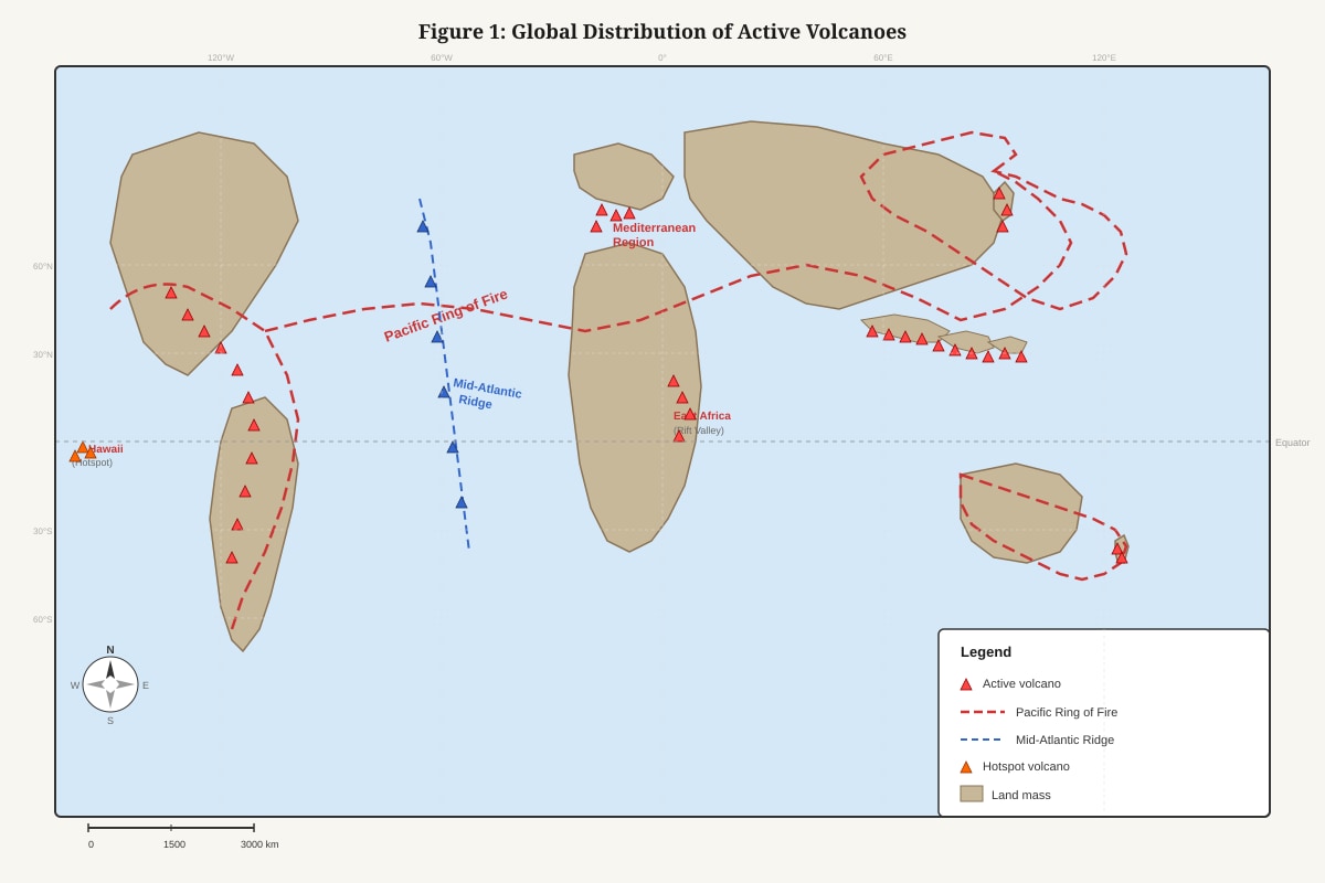
*Generated diagram for this question.*
A world map showing active volcanoes concentrated along the Pacific
Ring of Fire (western coasts of North and South America, eastern
coast of Asia, and island arcs of the western Pacific). Additional
clusters are visible along the Mid-Atlantic Ridge and in the
Mediterranean region. Few volcanoes are located in central Africa
and isolated hotspots such as Hawaii.
(a) Describe the global distribution of active volcanoes shown in Figure 1. [3 marks]
Answer:
(b) Explain why volcanoes are concentrated along the Pacific Ring of Fire. [3 marks]
Answer:
12. With the aid of a clearly labelled diagram, explain the processes that occur at a convergent plate boundary where an oceanic plate meets a continental plate. [6 marks]
Answer:
Draw your diagram in the space below, then provide your explanation.
Diagram:
[Space for diagram - approximately 8 lines]
_______________________________________________
_______________________________________________
_______________________________________________
_______________________________________________
_______________________________________________
_______________________________________________
_______________________________________________
_______________________________________________
Explanation:
13. Explain how the type of magma influences the shape of a volcano and the nature of its eruption. [4 marks]
Answer:
14. Study Figure 2, which shows the impacts of a volcanic eruption in a developing country.
Figure 2: Impacts of a Volcanic Eruption
    [Data Table]
    | Impact Category        | Details                                      |
    |------------------------|----------------------------------------------|
    | Casualties             | 350 deaths, 1,200 injuries                   |
    | Displacement           | 45,000 people evacuated                      |
    | Infrastructure Damage  | 12 bridges destroyed, 80 km of roads damaged |
    | Agricultural Loss      | 15,000 hectares of farmland covered in ash   |
    | Economic Cost          | Estimated US$500 million in damages          |
(a) With reference to Figure 2, describe the primary and secondary impacts of the volcanic eruption. [4 marks]
Answer:
(b) Suggest two reasons why the impacts of this eruption were severe. [2 marks]
Answer:
15. Describe the formation of a composite volcano (stratovolcano) and explain why eruptions from this type of volcano are often explosive. [4 marks]
Answer:
Section C: Data Response and Evaluation (16 marks)
Answer all questions in this section. Marks are indicated in brackets.
16. Study Figure 3, which shows earthquake data for two countries.
Figure 3: Earthquake Data Comparison
    | Factor                    | Country X (Developed) | Country Y (Developing) |
    |---------------------------|------------------------|------------------------|
    | Earthquake Magnitude      | 7.2                    | 7.0                    |
    | Depth of Focus            | 30 km                  | 25 km                  |
    | Population Density (area) | 350 persons/km²        | 420 persons/km²        |
    | Building Code Enforcement | Strict                 | Weak                   |
    | Early Warning System      | Yes                    | No                     |
    | Emergency Response Time   | 2 hours                | 48 hours               |
    | Fatalities                | 95                     | 8,200                  |
    | Economic Damage           | US$30 billion          | US$2 billion           |
(a) Compare the impacts of the earthquakes in Country X and Country Y. Support your answer with data from Figure 3. [3 marks]
Answer:
(b) Explain why the number of fatalities was much higher in Country Y despite the earthquake having a slightly lower magnitude. [4 marks]
Answer:
17. Study Figure 4, which shows a photograph of a coastal landform.
Figure 4: Coastal Landform Photograph
    [Photograph Description]
    A photograph showing a steep, vertical rock face rising from the
    sea. At the base of the cliff, a flat, rocky platform extends into
    the water. The cliff face shows visible horizontal layers of rock,
    with some overhanging sections and fallen rock debris at the base.
    Waves are visible breaking against the base of the cliff.
(a) Identify the coastal landform shown in Figure 4 and describe two of its features visible in the photograph. [3 marks]
Answer:
(b) Explain the processes that lead to the formation of this coastal landform. [4 marks]
Answer:
18. 'The magnitude of an earthquake is the most important factor determining the severity of its impacts.' How far do you agree with this statement? Support your answer with examples. [6 marks]
Answer:
19. Explain how the processes of erosion and deposition shape coastal environments. Use examples to support your answer. [5 marks]
Answer:
20. Study Figure 5, which shows a proposed development on a coastal area prone to tectonic activity.
Figure 5: Proposed Coastal Development
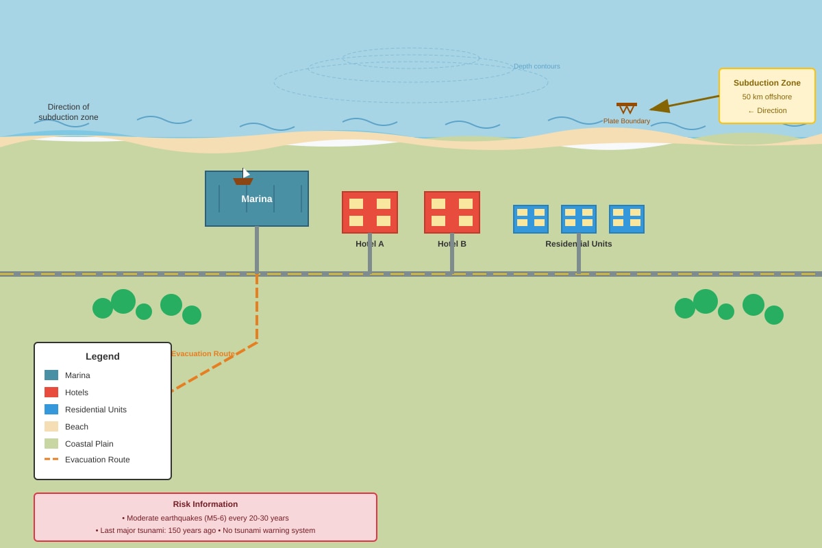
*Generated map for this question.*
A coastal map showing a proposed resort development on a low-lying
coastal plain. The area is located 50 km from a known subduction
zone. The development includes hotels, a marina, and residential
units. The coastal area has a history of moderate earthquakes
(magnitude 5-6) every 20-30 years. The last major tsunami in the
region occurred 150 years ago. The area currently has no tsunami
warning system and limited evacuation routes.
(a) Identify two tectonic hazards that could affect the proposed development. [2 marks]
Answer:
(b) Evaluate the risks of developing this coastal resort. Suggest measures that could be taken to reduce these risks. [6 marks]
Answer:
END OF QUIZ
Check your answers carefully before submitting.
Answers
O-Level Geography Quiz - Physical Geography
Answer Key and Marking Scheme
Total Marks: 50
Section A: Short Answer (10 marks)
1. Identify the layer of the Earth that lies directly beneath the crust. [1 mark]
Answer: Mantle
Marking Note: Accept "upper mantle" or "mantle." Do not accept "asthenosphere" alone (this is a zone within the mantle).
2. State the instrument used to measure the magnitude of an earthquake. [1 mark]
Answer: Seismometer / Seismograph
Marking Note: Accept either term. Do not accept "Richter scale" (this is a scale, not an instrument).
3. Name the type of plate boundary where two plates move away from each other. [1 mark]
Answer: Divergent plate boundary / Constructive plate boundary
Marking Note: Accept either term.
4. What is the term for the point on the Earth's surface directly above the focus of an earthquake? [1 mark]
Answer: Epicentre
Marking Note: Spelling must be recognisable. Accept "epicenter."
5. Identify the process by which heat is transferred through the mantle, driving plate movement. [1 mark]
Answer: Convection / Convection currents
Marking Note: Accept "mantle convection" or "convection currents in the mantle."
6. State the name of the scale used to measure the intensity of earthquake shaking based on observed effects. [1 mark]
Answer: Modified Mercalli Intensity Scale / Mercalli Scale
Marking Note: Accept "Mercalli Scale" or "MMI Scale." Do not accept "Richter Scale" (measures magnitude, not intensity).
7. Name the type of volcano characterised by broad, gently sloping sides formed by low-viscosity lava flows. [1 mark]
Answer: Shield volcano
Marking Note: Must state "shield volcano."
8. What is the term for a large ocean wave caused by an undersea earthquake or volcanic eruption? [1 mark]
Answer: Tsunami
Marking Note: Accept "tsunami" only. Do not accept "tidal wave."
9. Identify the layer of the Earth that is liquid and composed mainly of iron and nickel. [1 mark]
Answer: Outer core
Marking Note: Must specify "outer core." Do not accept "core" alone (the inner core is solid).
10. State the name of the supercontinent that existed approximately 250 million years ago before the continents drifted apart. [1 mark]
Answer: Pangaea
Marking Note: Accept "Pangaea" or "Pangea."
Section B: Structured Response (24 marks)
11. Study Figure 1, which shows the global distribution of active volcanoes.
(a) Describe the global distribution of active volcanoes shown in Figure 1. [3 marks]
Answer:
- Volcanoes are concentrated along the Pacific Ring of Fire, forming a horseshoe-shaped belt around the Pacific Ocean (1 mark).
- Additional clusters are found along the Mid-Atlantic Ridge, running north-south through the Atlantic Ocean (1 mark).
- Isolated volcanoes occur at hotspots, such as Hawaii in the central Pacific, and some volcanoes are found in the Mediterranean region and East Africa (1 mark).
Marking Notes:
- Award 1 mark for each distinct distribution pattern described with specific location reference.
- Must reference Figure 1 (implied by describing the pattern shown).
- Vague answers (e.g., "volcanoes are found near oceans") receive 0 marks.
(b) Explain why volcanoes are concentrated along the Pacific Ring of Fire. [3 marks]
Answer:
- The Pacific Ring of Fire is located along convergent plate boundaries where the Pacific Plate and other oceanic plates subduct beneath continental plates or other oceanic plates (1 mark).
- As the subducting plate sinks into the mantle, intense heat and pressure cause the oceanic crust to melt, generating magma (1 mark).
- This magma is less dense than the surrounding rock and rises through cracks and fissures to the surface, forming volcanoes along the plate boundary (1 mark).
Marking Notes:
- Award 1 mark for identifying the plate boundary type (convergent/subduction).
- Award 1 mark for explaining magma generation (melting of subducting plate).
- Award 1 mark for explaining magma rise and volcano formation.
- Answers must demonstrate cause-and-effect reasoning.
12. With the aid of a clearly labelled diagram, explain the processes that occur at a convergent plate boundary where an oceanic plate meets a continental plate. [6 marks]
Answer:
Diagram (2 marks):
- Two plates shown with arrows indicating convergent movement (oceanic plate moving towards and beneath continental plate) (1 mark).
- Labels: oceanic plate, continental plate, subduction zone, trench, magma chamber/rising magma, volcanic arc/mountains on continental plate (1 mark for at least 4 correct labels).
Explanation (4 marks):
- The denser oceanic plate subducts (sinks) beneath the less dense continental plate due to density differences (1 mark).
- As the oceanic plate descends into the mantle, increasing heat and pressure cause the release of water from the subducting plate, which lowers the melting point of the surrounding mantle rock, generating magma (1 mark).
- The magma, being less dense, rises through weaknesses in the overlying continental crust, forming a volcanic arc or mountain range on the continental plate (1 mark).
- Friction and pressure build-up along the subduction zone also cause earthquakes; an ocean trench forms at the point where the oceanic plate begins to descend (1 mark).
Marking Notes:
- Diagram must be present and labelled to receive diagram marks.
- Explanation must link processes logically.
- Accept alternative phrasing that conveys the same scientific concepts.
13. Explain how the type of magma influences the shape of a volcano and the nature of its eruption. [4 marks]
Answer:
- Low-viscosity (basaltic) magma: Contains low silica content (about 50%), allowing gases to escape easily. This produces gentle, effusive eruptions with lava flows that travel long distances, forming broad, gently sloping shield volcanoes (e.g., Mauna Loa, Hawaii) (2 marks).
- High-viscosity (rhyolitic/andesitic) magma: Contains high silica content (60-75%), trapping gases and building pressure. This produces explosive eruptions with pyroclastic flows and ash clouds. The thick lava does not flow far, building steep-sided composite volcanoes/stratovolcanoes (e.g., Mount Fuji, Japan) (2 marks).
Marking Notes:
- Award 2 marks for explaining low-viscosity magma → shield volcano + gentle eruption.
- Award 2 marks for explaining high-viscosity magma → composite volcano + explosive eruption.
- Must link magma properties (viscosity, silica content, gas content) to both volcano shape AND eruption style.
- Examples strengthen the answer but are not required for full marks.
14. Study Figure 2, which shows the impacts of a volcanic eruption in a developing country.
(a) With reference to Figure 2, describe the primary and secondary impacts of the volcanic eruption. [4 marks]
Answer:
- Primary impacts (immediate/direct results of the eruption): Casualties — 350 deaths and 1,200 injuries directly caused by the eruption (e.g., pyroclastic flows, ash falls, lava flows). Infrastructure damage — 12 bridges destroyed and 80 km of roads damaged by volcanic material (2 marks).
- Secondary impacts (indirect/consequential results): Displacement — 45,000 people evacuated, leading to humanitarian needs and temporary housing. Agricultural loss — 15,000 hectares of farmland covered in ash, destroying crops and affecting food security and livelihoods. Economic cost — estimated US$500 million in damages, including loss of productivity and reconstruction costs (2 marks).
Marking Notes:
- Award 2 marks for correctly identifying and describing primary impacts with data from Figure 2.
- Award 2 marks for correctly identifying and describing secondary impacts with data from Figure 2.
- Must distinguish between primary and secondary impacts.
- Must reference specific data from Figure 2.
(b) Suggest two reasons why the impacts of this eruption were severe. [2 marks]
Answer:
- The country is a developing country, which likely has limited resources for disaster preparedness, early warning systems, and emergency response, increasing vulnerability (1 mark).
- High population density in the affected area or reliance on agriculture means more people and livelihoods were exposed to the hazard, amplifying the impacts (1 mark).
Marking Notes:
- Award 1 mark for each valid reason with brief explanation.
- Accept other valid reasons: poor building quality, lack of evacuation plans, limited healthcare capacity, dependence on international aid.
- Must link reason to severity of impacts.
15. Describe the formation of a composite volcano (stratovolcano) and explain why eruptions from this type of volcano are often explosive. [4 marks]
Answer:
Formation (2 marks):
- Composite volcanoes form at convergent plate boundaries where subduction occurs. Magma generated from the melting subducting plate rises through the continental crust (1 mark).
- The volcano is built up over time by alternating layers of lava flows, volcanic ash, and pyroclastic material ejected during successive eruptions, creating a steep, conical shape (1 mark).
Explosive eruptions (2 marks):
- The magma in composite volcanoes has high silica content (andesitic/rhyolitic), making it highly viscous. This high viscosity traps gases within the magma (1 mark).
- Pressure builds up as gases cannot escape, until the pressure exceeds the strength of the overlying rock, resulting in a sudden, violent explosive eruption that ejects ash, bombs, and pyroclastic flows (1 mark).
Marking Notes:
- Award 2 marks for describing formation (plate boundary context + layered structure).
- Award 2 marks for explaining explosivity (high silica/viscosity + gas trapping + pressure build-up).
- Answers must demonstrate understanding of the link between magma composition and eruption style.
Section C: Data Response and Evaluation (16 marks)
16. Study Figure 3, which shows earthquake data for two countries.
(a) Compare the impacts of the earthquakes in Country X and Country Y. Support your answer with data from Figure 3. [3 marks]
Answer:
- Country Y suffered significantly higher fatalities (8,200 deaths) compared to Country X (95 deaths), despite the earthquakes having similar magnitudes (7.0 vs 7.2) (1 mark).
- However, Country X experienced much greater economic damage (US30billion)comparedtoCountryY(US2 billion), reflecting the higher value of infrastructure and property in the developed country (1 mark).
- The contrast shows that fatalities were far more severe in the developing country, while economic losses were higher in the developed country (1 mark).
Marking Notes:
- Award 1 mark for comparing fatalities with data.
- Award 1 mark for comparing economic damage with data.
- Award 1 mark for drawing out the contrast or pattern.
- Must use comparative language and reference specific data.
(b) Explain why the number of fatalities was much higher in Country Y despite the earthquake having a slightly lower magnitude. [4 marks]
Answer:
- Building code enforcement: Country Y has weak building code enforcement, meaning buildings were poorly constructed and more likely to collapse during shaking, causing more casualties. Country X has strict building codes with earthquake-resistant design (1 mark).
- Early warning system: Country Y has no early warning system, so residents had no advance notice to take protective action. Country X's early warning system allowed time for evacuation and shutdown of critical systems (1 mark).
- Emergency response: Country Y's emergency response time was 48 hours compared to 2 hours in Country X. The delay in search-and-rescue and medical assistance would have increased fatalities from injuries that could have been treated (1 mark).
- Level of development: As a developing country, Country Y likely has limited healthcare facilities, poorer infrastructure, and less public education on earthquake preparedness, all contributing to higher vulnerability and fatalities (1 mark).
Marking Notes:
- Award 1 mark for each valid explanation with clear reasoning.
- Must link factors to higher fatalities (not just list differences).
- Accept other valid factors: population density (Country Y is higher), depth of focus (Country Y is shallower, so shaking more intense at surface).
17. Study Figure 4, which shows a photograph of a coastal landform.
(a) Identify the coastal landform shown in Figure 4 and describe two of its features visible in the photograph. [3 marks]
Answer:
- Identification: The landform is a cliff (or sea cliff) with a wave-cut platform at its base (1 mark).
- Feature 1: The cliff face is steep and vertical, showing exposed horizontal layers of rock (strata), indicating it is composed of sedimentary or layered rock (1 mark).
- Feature 2: A flat, rocky platform (wave-cut platform) extends into the sea at the base of the cliff, with fallen rock debris visible, indicating active erosion and cliff retreat (1 mark).
Marking Notes:
- Award 1 mark for correct identification (must identify both cliff and wave-cut platform, or at minimum "cliff").
- Award 1 mark for each feature described with reference to the photograph.
- Features must be visible in the photograph description.
(b) Explain the processes that lead to the formation of this coastal landform. [4 marks]
Answer:
- Cliff formation: Waves erode the base of a coastal slope through hydraulic action (force of water compressing air in cracks) and abrasion (rocks and sediment thrown against the cliff by waves). This undercuts the cliff, forming a wave-cut notch (1 mark).
- As the notch deepens, the overhanging rock above becomes unsupported and eventually collapses due to gravity, causing the cliff to retreat inland. Repeated cycles of undercutting and collapse maintain the steep cliff face (1 mark).
- Wave-cut platform formation: As the cliff retreats, a gently sloping rocky surface is left behind at the base, exposed at low tide. This wave-cut platform is smoothed by continued wave action and abrasion (1 mark).
- The platform extends seaward until wave energy is dissipated over a wider area, reducing the erosive power at the cliff base and slowing further retreat (1 mark).
Marking Notes:
- Award 1 mark for each process explained with correct terminology.
- Must describe sequence: undercutting → collapse → retreat → platform formation.
- Accept references to specific erosion processes (hydraulic action, abrasion, solution, attrition).
18. 'The magnitude of an earthquake is the most important factor determining the severity of its impacts.' How far do you agree with this statement? Support your answer with examples. [6 marks]
Answer:
Introduction (1 mark):
- Earthquake magnitude measures the energy released at the focus. While magnitude is important, the severity of impacts depends on multiple interacting factors including human vulnerability, level of preparedness, and local geographical conditions.
Arguments agreeing — magnitude matters (2 marks):
- Higher magnitude earthquakes release more energy, causing stronger ground shaking over a wider area, which can lead to more building collapse and infrastructure damage.
- Example: The 2011 Tohoku earthquake (magnitude 9.0) caused widespread destruction across northeastern Japan and generated a devastating tsunami, demonstrating that extreme magnitudes can overwhelm even well-prepared countries.
Arguments disagreeing — other factors are equally or more important (2 marks):
- Level of development and preparedness: The 2010 Haiti earthquake (magnitude 7.0) caused over 200,000 deaths due to poor building quality, lack of enforcement of building codes, and limited emergency response capacity. In contrast, the 2011 Christchurch earthquake (magnitude 6.3) caused 185 deaths in a developed country with stricter building standards.
- Depth of focus and proximity to population centres: A shallow-focus, moderate-magnitude earthquake near a densely populated area can be more destructive than a deep-focus, high-magnitude earthquake in a remote area.
- Secondary hazards: Tsunamis, landslides, and fires triggered by earthquakes can cause more damage than the shaking itself (e.g., 2004 Indian Ocean tsunami).
Conclusion (1 mark):
- Magnitude is a significant factor but not the most important in isolation. The severity of earthquake impacts is determined by the interaction of hazard characteristics (magnitude, depth, proximity) with human factors (vulnerability, preparedness, response capacity). In many cases, human factors are more decisive in determining the scale of disaster.
Marking Notes:
- Award up to 2 marks for arguments supporting the statement.
- Award up to 2 marks for arguments challenging the statement.
- Award 1 mark for a balanced introduction that frames the debate.
- Award 1 mark for a reasoned conclusion that addresses "how far."
- Examples must be relevant and specific (named countries/events).
- One-sided answers (only agreeing or only disagreeing) limited to 4 marks maximum.
19. Explain how the processes of erosion and deposition shape coastal environments. Use examples to support your answer. [5 marks]
Answer:
Erosional processes and landforms (2-3 marks):
- Hydraulic action: Waves compress air in cracks in coastal rocks; the pressure weakens and fractures the rock, forming features such as cliffs, wave-cut notches, and caves.
- Abrasion/Corrasion: Waves throw sand, pebbles, and boulders against the coast, wearing away rock surfaces. This contributes to cliff retreat and the formation of wave-cut platforms.
- Solution/Corrosion: Weak acids in seawater dissolve certain rock types (e.g., limestone), forming features such as coastal karst landscapes.
- Example: The White Cliffs of Dover (UK) are formed by erosion of chalk; the Twelve Apostles (Australia) are sea stacks formed by erosion of headlands.
Depositional processes and landforms (2-3 marks):
- Longshore drift: Waves approach the coast at an angle, carrying sediment along the shore. When wave energy decreases (e.g., in sheltered bays or where the coastline changes direction), sediment is deposited.
- Landforms created: Beaches form where constructive waves deposit sand and shingle. Spits form where longshore drift extends sediment across a bay or estuary mouth. Bars and tombolos form where sediment connects two land areas.
- Example: Chesil Beach (UK) is a tombolo formed by deposition; the Farewell Spit (New Zealand) is a sand spit extending from longshore drift deposition.
Marking Notes:
- Award up to 3 marks for explaining erosional processes and landforms with examples.
- Award up to 3 marks for explaining depositional processes and landforms with examples.
- Maximum 5 marks total — answers do not need to cover all points to achieve full marks.
- Must include at least one example for full marks.
- Must explain processes, not just list landforms.
20. Study Figure 5, which shows a proposed development on a coastal area prone to tectonic activity.
(a) Identify two tectonic hazards that could affect the proposed development. [2 marks]
Answer:
- Earthquakes (due to proximity to a subduction zone, 50 km away) (1 mark).
- Tsunamis (generated by undersea earthquakes at the subduction zone; the area is low-lying coastal plain with a history of tsunamis) (1 mark).
Marking Notes:
- Award 1 mark for each correctly identified hazard.
- Accept "volcanic eruption" if justified (subduction zones can produce volcanoes), but earthquakes and tsunamis are more directly supported by the data.
- Must be tectonic hazards (not general hazards like flooding).
(b) Evaluate the risks of developing this coastal resort. Suggest measures that could be taken to reduce these risks. [6 marks]
Answer:
Risk evaluation (3 marks):
- High earthquake risk: The area is located only 50 km from a subduction zone with a history of moderate earthquakes (magnitude 5-6) every 20-30 years. Ground shaking could cause building collapse, infrastructure damage, and casualties, especially given the low-lying coastal location (1 mark).
- Tsunami risk: The area is a low-lying coastal plain, making it highly vulnerable to tsunami inundation. Although the last major tsunami was 150 years ago, the geological record suggests tsunamis are possible. The absence of a tsunami warning system and limited evacuation routes significantly increase the risk (1 mark).
- Compounding factors: The development includes hotels, a marina, and residential units, meaning high population density and economic investment at risk. As a developing area (implied by lack of warning system), response capacity may be limited, increasing vulnerability. The combination of high hazard probability and high vulnerability makes the risk level substantial (1 mark).
Risk reduction measures (3 marks):
- Building design and land-use planning: Enforce strict earthquake-resistant building codes for all structures. Avoid construction in the most vulnerable low-lying areas; designate tsunami inundation zones as open space or parkland rather than high-occupancy buildings. Elevate critical infrastructure above projected tsunami run-up levels (1 mark).
- Early warning and evacuation systems: Install a tsunami early warning system (seismic sensors and sea-level monitoring buoys) connected to loudspeakers and mobile alerts. Construct clearly marked evacuation routes leading to designated high-ground assembly points. Conduct regular community drills (1 mark).
- Preparedness and education: Train resort staff and residents in earthquake and tsunami response procedures. Develop and publicise emergency plans. Stockpile emergency supplies (food, water, medical kits) at safe locations. Establish communication protocols with regional disaster management agencies (1 mark).
Marking Notes:
- Award up to 3 marks for evaluating risks (must identify specific risks and explain why they are significant).
- Award up to 3 marks for suggesting appropriate, specific risk reduction measures.
- Measures must be relevant to the identified hazards and context.
- Answers should demonstrate evaluation (weighing factors, making judgements) rather than just listing.
- Maximum 6 marks total.
END OF ANSWER KEY
Free quiz and exam paper access
Enter your details to view this paper
Your access is remembered on this device.