From Real Exams Quiz
O Level Geography Physical Geography Quiz
Free O Level Geography Physical Geography quiz, DeepSeek Exam version, with questions, answers, and O Level-style practice for Singapore students.
These static practice materials are generated from the site's syllabus and paper-generation workflow, with source and model context shown so students and parents can evaluate the material before use.
Questions
O-Level Geography Quiz - Physical Geography
Name: _________________________ Class: _________________________ Date: _________________________ Score: ______ / 50
Duration: 45 minutes Total Marks: 50
Instructions:
- Answer ALL questions in the spaces provided.
- Read each question carefully and note the mark allocation.
- Where diagrams or data are provided, refer to them explicitly in your answers.
- For evaluation questions, present balanced arguments and reach a reasoned conclusion.
Section A: Weather, Climate & Atmospheric Processes (Questions 1–5)
[15 marks]
1. Other than a thermometer, identify an instrument used to measure wind speed.
[1 mark]
2. Study Figure 1, which shows the average monthly temperature and rainfall for Location X.
| Month | Jan | Feb | Mar | Apr | May | Jun | Jul | Aug | Sep | Oct | Nov | Dec |
|---|---|---|---|---|---|---|---|---|---|---|---|---|
| Temperature (°C) | 26 | 27 | 27 | 28 | 28 | 27 | 27 | 27 | 27 | 27 | 26 | 26 |
| Rainfall (mm) | 250 | 180 | 210 | 280 | 310 | 180 | 170 | 190 | 220 | 290 | 310 | 300 |
(a) With reference to Figure 1, describe the temperature pattern at Location X. [2 marks]
(b) Suggest what type of climate Location X experiences. Explain your answer with reference to the data. [3 marks]
3. Explain how the enhanced greenhouse effect contributes to global warming. [4 marks]
4. Describe the difference between weather and climate. [2 marks]
5. With the aid of a well-labelled diagram, explain the formation of convectional rainfall. [3 marks]
Draw your diagram in the space below. Label all key features.
Section B: Coastal Processes & Landforms (Questions 6–10)
[15 marks]
6. Study Photograph A, which shows a coastal landform.
[Photograph A: A gently sloping sandy beach with low waves breaking near the shore. Low vegetation is visible behind the beach.]
(a) Identify the coastal landform shown in Photograph A. [1 mark]
(b) Describe the features of this landform as shown in the photograph. [2 marks]
(c) Account for the formation of this landform. [3 marks]
7. Explain how beach material can affect the slope of a beach. [3 marks]
8. Distinguish between constructive and destructive waves. [3 marks]
9. Describe the process of longshore drift. [2 marks]
10. Explain how a spit is formed. [4 marks]
Section C: Tectonic Processes & Hazards (Questions 11–15)
[12 marks]
11. Study Figure 2, which shows the global distribution of earthquakes and volcanoes.
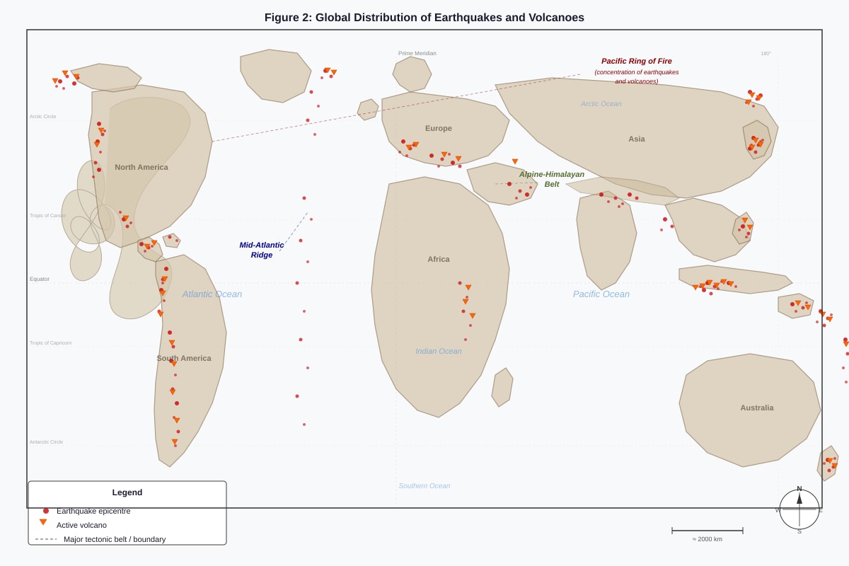
Generated figure for this question.
(a) Describe the distribution of earthquakes and volcanoes shown in Figure 2. [2 marks]
(b) Explain why earthquakes and volcanoes are concentrated in these areas. [3 marks]
12. With the aid of a well-labelled diagram, explain the processes that occur at an oceanic-continental convergent plate boundary. [5 marks]
Draw your diagram in the space below. Label all key features.
13. Identify two primary impacts of a volcanic eruption. [2 marks]
14. Explain how a tsunami is generated by an undersea earthquake. [3 marks]
15. Describe two strategies used to reduce the impacts of tectonic hazards. [2 marks]
Section D: Integrated Physical Geography & Evaluation (Questions 16–20)
[8 marks]
16. Explain how deforestation can influence both local climate and coastal processes. [2 marks]
17. Describe one way in which climate change may affect coastal environments. [1 mark]
18. Explain how tectonic uplift can influence coastal landforms. [2 marks]
19. 'Coastal erosion is a more serious threat to human populations than tectonic hazards.' How far do you agree with this statement? Support your answer with relevant examples. [8 marks]
20. Evaluate the effectiveness of hard engineering approaches in managing coastal erosion. [3 marks]
Answers
O-Level Geography Quiz - Physical Geography — Answer Key & Marking Scheme
Total Marks: 50
Section A: Weather, Climate & Atmospheric Processes (Questions 1–5)
Question 1 [1 mark]
Answer: Anemometer
Marking notes:
- Award 1 mark for "anemometer" (accept spelling variations).
- Do NOT accept "thermometer" (excluded in question).
- Do NOT accept "weather vane" or "wind vane" (measures direction, not speed).
Question 2(a) [2 marks]
Answer: The temperature at Location X remains consistently high throughout the year, ranging from 26°C to 28°C. There is very little seasonal variation, with only a 2°C difference between the coolest and warmest months.
Marking notes:
- 1 mark: Identifies high temperatures / consistently warm (with reference to data, e.g., "26–28°C").
- 1 mark: Identifies small annual temperature range / little seasonal variation (with reference to data, e.g., "only 2°C difference").
- Award 1 mark only if answer is vague or lacks data reference.
Question 2(b) [3 marks]
Answer: Location X experiences an equatorial / tropical equatorial climate. This is characterised by high temperatures throughout the year (26–28°C) and high annual rainfall (over 2,000 mm). The rainfall is distributed throughout the year with no distinct dry season, which is typical of equatorial climates.
Marking notes:
- 1 mark: Correctly identifies climate type as equatorial / tropical equatorial / tropical rainforest climate.
- 1 mark: Explains with reference to temperature data (consistently high, small range).
- 1 mark: Explains with reference to rainfall data (high total, distributed throughout year, no dry season).
- Accept "tropical monsoon climate" only if justified with rainfall pattern reasoning.
Question 3 [4 marks]
Answer: The enhanced greenhouse effect occurs when human activities release additional greenhouse gases (such as carbon dioxide, methane, and nitrous oxide) into the atmosphere. These gases trap more outgoing longwave radiation from the Earth's surface, preventing it from escaping into space. This leads to a net increase in heat retained within the atmosphere, causing global temperatures to rise. Key human activities include the burning of fossil fuels, deforestation, and industrial processes.
Marking notes:
- 1 mark: Identifies enhanced greenhouse effect as increased greenhouse gas concentrations from human activities.
- 1 mark: Explains mechanism — greenhouse gases trap outgoing longwave/infrared radiation.
- 1 mark: Links trapped radiation to increased atmospheric heat / global temperature rise.
- 1 mark: Provides examples of human activities (burning fossil fuels, deforestation, agriculture, industry) OR names specific greenhouse gases (CO₂, methane, nitrous oxide).
- Award partial marks for incomplete explanations.
Question 4 [2 marks]
Answer: Weather refers to the day-to-day atmospheric conditions at a specific place and time, including temperature, rainfall, and wind. Climate refers to the average weather conditions of a place measured over a long period of time, typically 30 years or more.
Marking notes:
- 1 mark: Defines weather as short-term / day-to-day atmospheric conditions.
- 1 mark: Defines climate as long-term average weather conditions (must mention time scale, e.g., "30 years" or "long period").
- Accept alternative phrasing that clearly distinguishes the two concepts.
Question 5 [3 marks]
Answer: Convectional rainfall forms when the sun heats the Earth's surface, causing warm air to rise. As the warm, moist air rises, it cools and condenses at higher altitudes, forming cumulonimbus clouds. When the water droplets become too heavy, they fall as rain, often accompanied by thunder and lightning.
Diagram should show:
- Ground surface heated by the sun
- Rising warm air currents (arrows)
- Cooling and condensation at altitude
- Cumulonimbus cloud formation
- Rainfall from the cloud
Marking notes:
- 1 mark: Diagram is present and clearly labelled with at least three features (e.g., sun heating ground, rising air, cloud formation, rainfall).
- 1 mark: Explains heating of ground → warm air rises.
- 1 mark: Explains cooling → condensation → cloud formation → rainfall.
- Award 2 marks maximum if diagram is missing or unlabelled.
Section B: Coastal Processes & Landforms (Questions 6–10)
Question 6(a) [1 mark]
Answer: Beach
Marking notes:
- Award 1 mark for "beach" or "sandy beach."
- Do NOT accept "coastline" or "shore" (too vague).
Question 6(b) [2 marks]
Answer: The beach shown in Photograph A has a gentle slope and is composed of sand. Low waves are breaking near the shore, indicating low wave energy. Low vegetation is visible behind the beach, suggesting a stable backshore area.
Marking notes:
- 1 mark: Describes physical features with reference to photograph (e.g., gentle slope, sandy material, low waves).
- 1 mark: Provides additional detail (e.g., vegetation behind beach, low wave energy, wide beach).
- Must reference the photograph explicitly or implicitly (e.g., "as shown in the photograph").
Question 6(c) [3 marks]
Answer: The beach is formed by the deposition of sediment transported by waves and currents. Sand and other materials are carried by longshore drift along the coast and deposited in areas of low wave energy, such as sheltered bays. Constructive waves, which have a stronger swash than backwash, push sediment up the shore, gradually building up the beach. Over time, the accumulation of sediment creates the gently sloping landform visible in the photograph.
Marking notes:
- 1 mark: Identifies deposition as the dominant process.
- 1 mark: Explains sediment transport (longshore drift, wave action) bringing material to the site.
- 1 mark: Explains accumulation process (constructive waves, low energy environment, swash > backwash).
- Award 2 marks if explanation is partially complete.
Question 7 [3 marks]
Answer: Beach material affects slope through permeability and particle size. Coarse material such as shingle or pebbles has high permeability, allowing water to percolate quickly. This reduces backwash energy, resulting in a steeper beach profile. Fine material such as sand has lower permeability, retaining more water. This increases backwash energy, creating a gentler slope. Additionally, coarse material has greater friction, which also contributes to steeper slopes.
Marking notes:
- 1 mark: Identifies relationship — coarse material = steep slope; fine material = gentle slope.
- 1 mark: Explains permeability mechanism (coarse = high permeability, less backwash; fine = low permeability, more backwash).
- 1 mark: Provides additional detail (friction, water retention, swash/backwash balance).
- Award 2 marks if explanation is partially complete.
Question 8 [3 marks]
Answer: Constructive waves have a stronger swash than backwash, depositing sediment on the shore and building up the beach. They are typically low in height, with a long wavelength and low frequency. Destructive waves have a stronger backwash than swash, eroding sediment from the shore. They are typically high in height, with a short wavelength and high frequency, often occurring during storms.
Marking notes:
- 1 mark: Distinguishes by swash/backwash balance (constructive: swash > backwash; destructive: backwash > swash).
- 1 mark: Links constructive waves to deposition / beach building; destructive waves to erosion.
- 1 mark: Describes wave characteristics (height, wavelength, frequency) OR conditions (calm vs. storm).
- Award 2 marks if distinction is partially clear.
Question 9 [2 marks]
Answer: Longshore drift is the movement of sediment along a coastline. Waves approach the shore at an angle, carrying sediment up the beach in the direction of the swash. The backwash then carries sediment straight back down the beach under gravity. This zigzag movement results in the net transport of sediment along the coast.
Marking notes:
- 1 mark: Defines longshore drift as movement of sediment along the coast.
- 1 mark: Describes the process (angled swash, perpendicular backwash, zigzag movement).
- Award 1 mark if description is vague or incomplete.
Question 10 [4 marks]
Answer: A spit is formed by longshore drift depositing sediment where the coastline changes direction, such as at a river mouth or a change in the angle of the coast. As sediment is transported along the coast, it is deposited when wave energy decreases. Over time, the deposited material builds up and extends outwards, forming a narrow ridge of sand or shingle. The end of the spit may become curved due to changes in wave direction or the influence of secondary currents. A salt marsh may develop in the sheltered water behind the spit.
Marking notes:
- 1 mark: Identifies longshore drift as the key process.
- 1 mark: Explains deposition at a change in coastline direction / decrease in wave energy.
- 1 mark: Describes the extension and growth of the spit over time.
- 1 mark: Mentions additional features (curved end, salt marsh formation) or secondary processes.
- Award 3 marks if explanation is partially complete.
Section C: Tectonic Processes & Hazards (Questions 11–15)
Question 11(a) [2 marks]
Answer: Earthquakes and volcanoes are concentrated in narrow belts along plate boundaries. Major concentrations are found along the Pacific Ring of Fire, the Mid-Atlantic Ridge, and the Alpine-Himalayan Belt. There are relatively few earthquakes and volcanoes in the interior of tectonic plates.
Marking notes:
- 1 mark: Identifies concentration along plate boundaries / narrow belts.
- 1 mark: Names specific zones (Pacific Ring of Fire, Mid-Atlantic Ridge, Alpine-Himalayan Belt) OR notes absence in plate interiors.
- Award 1 mark if answer is vague or lacks specific reference to Figure 2.
Question 11(b) [3 marks]
Answer: Earthquakes and volcanoes are concentrated along plate boundaries because these are zones where tectonic plates interact. At convergent boundaries, plates collide, causing subduction or collision, which generates earthquakes and volcanic activity due to friction and melting. At divergent boundaries, plates move apart, allowing magma to rise and create volcanoes, with earthquakes occurring due to tensional forces. At transform boundaries, plates slide past each other, causing earthquakes due to friction.
Marking notes:
- 1 mark: Links distribution to plate boundaries / plate interactions.
- 1 mark: Explains one type of boundary process (convergent, divergent, or transform) with reference to earthquakes or volcanoes.
- 1 mark: Explains a second type of boundary process OR provides additional detail (e.g., subduction melting, magma rising).
- Award 2 marks if explanation is partially complete.
Question 12 [5 marks]
Answer: At an oceanic-continental convergent plate boundary, the denser oceanic plate subducts beneath the less dense continental plate. This creates a deep ocean trench at the point of subduction. As the oceanic plate descends, it melts due to increasing heat and pressure in the mantle. The molten magma rises through cracks in the continental crust, forming volcanoes. The collision also causes folding and faulting of the continental crust, leading to the formation of fold mountains. Earthquakes occur due to the friction between the plates.
Diagram should show:
- Oceanic plate and continental plate with arrows indicating movement
- Subduction zone with oceanic plate descending
- Ocean trench
- Magma rising and volcano formation on the continental plate
- Fold mountains
Marking notes:
- 1 mark: Diagram is present and clearly labelled with at least four features (e.g., oceanic plate, continental plate, subduction, trench, volcanoes, fold mountains).
- 1 mark: Identifies subduction of oceanic plate beneath continental plate.
- 1 mark: Explains melting of oceanic plate and magma formation.
- 1 mark: Explains volcano formation from rising magma.
- 1 mark: Explains formation of fold mountains and/or occurrence of earthquakes.
- Award 4 marks maximum if diagram is missing or poorly labelled.
Question 13 [2 marks]
Answer: Two primary impacts of a volcanic eruption are:
- Loss of life and injury due to pyroclastic flows, lava flows, and ash falls.
- Destruction of property and infrastructure, including buildings, roads, and farmland.
Marking notes:
- 1 mark: Identifies one valid primary impact (e.g., loss of life, injury, destruction of property).
- 1 mark: Identifies a second valid primary impact.
- Accept other primary impacts such as ash cloud disruption, lahars, or volcanic gases.
- Do NOT accept secondary impacts (e.g., famine, disease) unless clearly linked as immediate consequences.
Question 14 [3 marks]
Answer: A tsunami is generated by an undersea earthquake when there is a sudden vertical displacement of the seafloor. This displacement pushes a large volume of water upwards, creating waves that travel outwards in all directions. As the waves approach shallow coastal waters, they slow down and increase in height, often resulting in devastating flooding when they reach the shore.
Marking notes:
- 1 mark: Identifies undersea earthquake / vertical seafloor displacement as the cause.
- 1 mark: Explains displacement of water and wave generation.
- 1 mark: Describes wave behaviour in shallow water (increase in height, coastal flooding).
- Award 2 marks if explanation is partially complete.
Question 15 [2 marks]
Answer: Two strategies to reduce the impacts of tectonic hazards are:
- Land-use planning, such as avoiding construction in high-risk areas (e.g., near fault lines or volcano slopes).
- Early warning systems, which detect seismic activity and provide alerts to allow for evacuation.
Marking notes:
- 1 mark: Identifies one valid strategy (e.g., land-use planning, early warning systems, building codes, education).
- 1 mark: Identifies a second valid strategy.
- Accept any reasonable strategy with brief explanation.
Section D: Integrated Physical Geography & Evaluation (Questions 16–20)
Question 16 [2 marks]
Answer: Deforestation can influence local climate by reducing evapotranspiration, leading to decreased rainfall and increased temperatures. It can affect coastal processes by increasing soil erosion and sediment runoff into rivers, which may lead to increased sediment deposition along the coast, potentially altering coastal landforms.
Marking notes:
- 1 mark: Explains influence on local climate (e.g., reduced rainfall, higher temperatures).
- 1 mark: Explains influence on coastal processes (e.g., increased sediment supply, deposition).
- Award 1 mark if only one aspect is addressed.
Question 17 [1 mark]
Answer: Climate change may cause sea-level rise, leading to increased coastal erosion and flooding of low-lying coastal areas.
Marking notes:
- 1 mark: Identifies a valid effect (e.g., sea-level rise, increased erosion, more frequent storm surges, coral bleaching).
- Accept any reasonable effect with brief explanation.
Question 18 [2 marks]
Answer: Tectonic uplift can raise coastal land above sea level, forming features such as raised beaches and marine terraces. These landforms are former shore platforms or beaches that have been elevated by tectonic forces, often found along convergent plate boundaries.
Marking notes:
- 1 mark: Identifies raised beaches or marine terraces as resulting landforms.
- 1 mark: Explains the process of uplift raising former coastal features above sea level.
- Award 1 mark if explanation is vague.
Question 19 [8 marks]
Answer: This is an evaluative question requiring a balanced argument. Students should discuss both coastal erosion and tectonic hazards, comparing their severity as threats to human populations.
Arguments that coastal erosion is more serious:
- Coastal erosion is a continuous, ongoing process affecting many densely populated coastal areas worldwide (e.g., Holderness Coast, UK; parts of Bangladesh).
- It leads to loss of land, property, and infrastructure gradually, displacing communities over time.
- Sea-level rise due to climate change is accelerating coastal erosion, increasing the threat.
- Coastal populations are often economically dependent on coastal resources, making them vulnerable.
Arguments that tectonic hazards are more serious:
- Tectonic hazards (earthquakes, volcanic eruptions, tsunamis) can cause sudden, catastrophic loss of life and widespread destruction (e.g., 2004 Indian Ocean tsunami, 2011 Tōhoku earthquake and tsunami).
- They can affect large areas with little warning, making evacuation difficult.
- Secondary impacts (e.g., fires, landslides, nuclear accidents) can compound the disaster.
- Some tectonic hazards, like volcanic eruptions, can have global climatic effects.
Conclusion: Students should reach a reasoned conclusion, weighing the evidence. For example, while coastal erosion is a persistent and growing threat, tectonic hazards can cause more immediate and large-scale devastation, making them arguably more serious in terms of sudden impact. However, the long-term cumulative effects of coastal erosion may affect more people over time.
Marking notes:
- Level 3 (6–8 marks): Balanced argument with well-developed points on both sides. Uses relevant examples. Reaches a clear, reasoned conclusion.
- Level 2 (3–5 marks): Some balance, with points on both sides but may be uneven. Limited or generic examples. Conclusion present but may be weak.
- Level 1 (1–2 marks): One-sided argument or only superficial points. No or irrelevant examples. No clear conclusion.
- 0 marks: No response or response does not address the question.
Question 20 [3 marks]
Answer: Hard engineering approaches, such as building sea walls, groynes, and revetments, are effective in protecting specific areas from coastal erosion by absorbing or deflecting wave energy. However, they can be expensive to build and maintain, and may cause increased erosion further down the coast by disrupting natural sediment transport. They also often have negative visual and environmental impacts. Overall, while effective in the short term, they may not be sustainable or equitable in the long term.
Marking notes:
- 1 mark: Identifies effectiveness (e.g., protects specific areas, reduces erosion).
- 1 mark: Identifies limitations (e.g., cost, downstream erosion, environmental impact).
- 1 mark: Provides a balanced evaluation or reasoned conclusion.
- Award 2 marks if evaluation is partially complete.
Free quiz and exam paper access
Enter your details to view this paper
Your access is remembered on this device.