A-Level Geography H2 Quiz - Physical Geography
Name: ___________________________
Class: ___________________________
Date: ___________________________
Score: ___________ / 40
Duration: 60 minutes
Total Marks: 40
Instructions: Answer all 20 questions. Section A (Q1–10) is short structured/data-based (1–3 marks each). Section B (Q11–15) requires explanation and application (4–5 marks each). Section C (Q16–20) involves analysis, evaluation, and diagram interpretation (5–8 marks each). Use clear geographical terminology. Show reasoning where marks are awarded for explanation.
Section A: Basic Concepts and Data Recognition (Questions 1–10)
1. State the Köppen-Geiger climate classification code for a tropical rainforest climate. [1]
2. Name the atmospheric circulation cell that drives rainfall in the humid tropics through rising air near the equator. [1]
3. Identify the type of mass movement shown in the photograph below where a saturated soil layer moves slowly downhill as a cohesive block. [1]
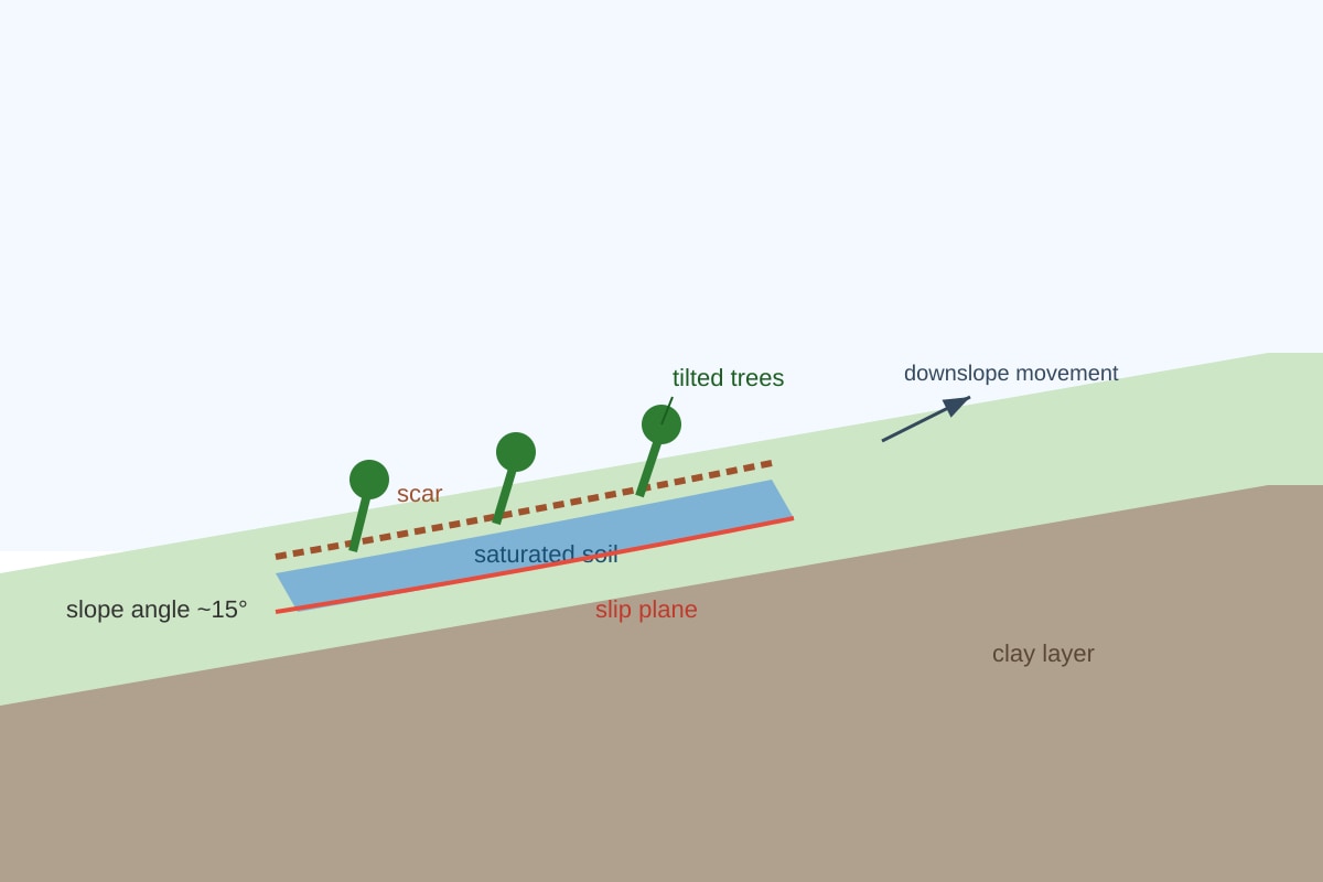
Generated figure for Q3.
4. Give one example of a regulating ecosystem service provided by a tropical forest. [1]
5. State one natural input and one natural output in a tropical drainage basin hydrological system. [2]
Input: ___________________________
Output: ___________________________
6. According to the syllabus, what is the key distinguishing climatic characteristic of all tropical climate zones? [1]
7. Name the phase of the El Niño Southern Oscillation (ENSO) associated with reduced rainfall over the western tropical Pacific. [1]
8. Identify the chemical weathering process in which carbon dioxide dissolved in rainwater forms a weak acid that dissolves limestone. [1]
9. State the term used for water that flows slowly through the soil zone to a river via throughflow and eventually as baseflow. [1]
10. Name one human activity that can compromise provisioning ecosystem services in a tropical catchment. [1]
Section B: Explanation and Application (Questions 11–15)
11. Explain two ways in which high temperatures influence the hydrological cycle in the humid tropics. [4]
12. Using the resource below, describe the vegetation structure and mean biomass of a typical tropical rainforest as shown. [3]

Generated graph for Q12.
13. Explain how monsoon circulations in humid tropical Asia produce a seasonal rainfall peak. [4]
14. A drainage basin has the following annual water balance (mm): precipitation 2000, evapotranspiration 1200, change in storage +100. Calculate the river discharge in mm. Show your working. [3]
Working: __________________________________________________
Answer: ___________________________ mm
15. Explain how deforestation in a tropical drainage basin can increase the risk of fluvial flooding downstream. [5]
Section C: Analysis, Evaluation, and Interpretation (Questions 16–20)
16. The graph below shows monthly rainfall for Station X (humid tropics). Using the data, identify the climate type (Af, Am, or Aw) and give two pieces of evidence from the graph to support your answer. [5]
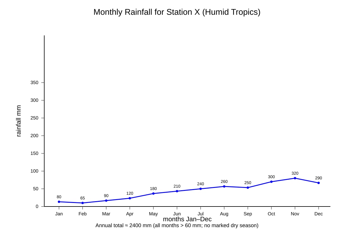
Generated graph for Q16.
Climate type: ___________________________
Evidence 1: __________________________________________________
Evidence 2: __________________________________________________
17. Explain the processes of chemical weathering that lead to the formation of a karst landscape in tropical limestone regions. [7]
18. Study the map extract below showing a tropical river basin. Identify two natural factors and two human factors that could increase fluvial flood risk in the basin. [4]
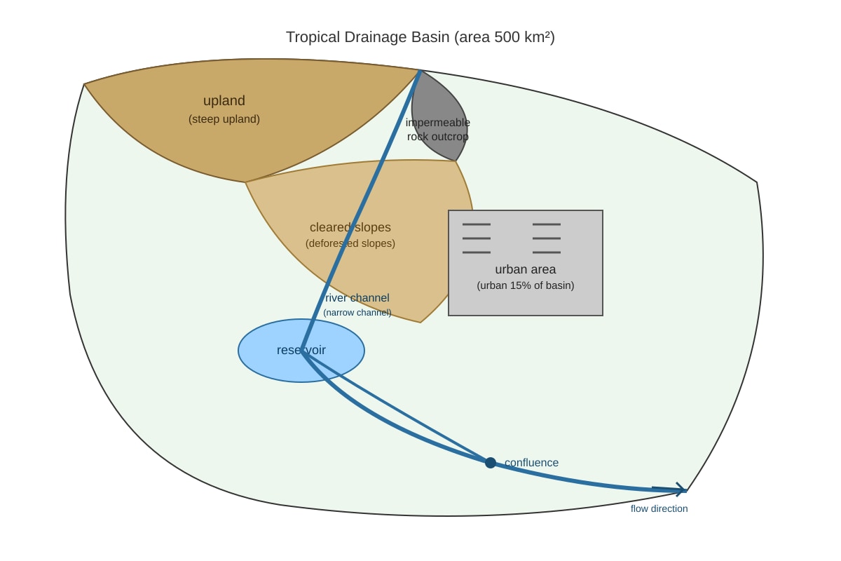
Generated map for Q18.
Natural 1: ___________________________ Natural 2: ___________________________
Human 1: ___________________________ Human 2: ___________________________
19. To what extent can hard-engineering strategies (e.g. levees, dams) fully control fluvial flooding in the humid tropics? Evaluate with reference to limitations. [6]
20. The diagram below shows a tropical drainage basin with labelled stores and flows. Name two stores and two flows, and explain how a prolonged drought would alter the relationship between them. [8]
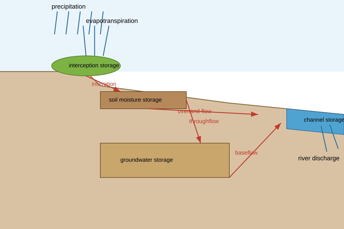
Generated diagram for Q20.
Stores: (a) __________________ (b) __________________
Flows: (c) __________________ (d) __________________
Explanation: __________________________________________________
</stage5_quiz_answers_md>
A-Level Geography H2 Quiz - Physical Geography (Answer Key)
Total Marks: 40
Topic: Physical Geography (Syllabus 9173, Cluster 2)
Section A (Q1–10): 10 marks
Q1. [1]
Answer: Af
Teaching note: The Köppen-Geiger code for tropical rainforest is Af (humid tropics, no dry season, all months >60 mm rainfall). Accept "Af" only.
Q2. [1]
Answer: Hadley cell
Teaching note: Hadley cells are tropical atmospheric circulation cells with rising air at the Intertropical Convergence Zone (ITCZ), producing convectional rainfall.
Q3. [1]
Answer: Slump (or translational slide / mudslide if coherent saturated mass)
Teaching note: The image shows a saturated cohesive block moving on a slip plane — classic slump. Common mistake: confusing with fall (free fall of rock).
Q4. [1]
Answer: Any one: climate regulation, flood regulation, water purification, carbon sequestration.
Teaching note: Regulating services are those that regulate environmental conditions. Provisioning = food/water; cultural = recreation; support = nutrient cycling.
Q5. [2]
Answer: Input: precipitation (or snowmelt); Output: evapotranspiration (or river discharge).
Teaching note: 1 mark each. Inputs add water; outputs remove water from the basin.
Q6. [1]
Answer: High temperatures throughout the year (mean monthly temp >18°C).
Teaching note: Syllabus states high temperature is the key distinguishing feature; rainfall varies.
Q7. [1]
Answer: El Niño
Teaching note: El Niño = warm SST east Pacific, suppressed rainfall in west tropical Pacific. La Niña = opposite.
Q8. [1]
Answer: Carbonation (or solution / chemical weathering via carbonic acid)
Teaching note: Rain + CO₂ → H₂CO₃ (weak carbonic acid) dissolves CaCO₃ in limestone.
Q9. [1]
Answer: Baseflow (or throughflow leading to baseflow)
Teaching note: Baseflow is slow groundwater flow to river; throughflow is soil-zone movement.
Q10. [1]
Answer: Any one: dam construction, over-extraction of water, pollution, invasive species introduction, habitat destruction.
Teaching note: Must compromise provisioning (e.g. fish, fresh water).
Section B (Q11–15): 15 marks
Q11. [4]
Answer (2 ways, 2 marks each):
- High temp → high potential evapotranspiration → more moisture returned to atmosphere, intense rainfall.
- High temp → greater convection → rising air → cumulonimbus → heavy orographic/convectional storms.
Teaching note: Link temperature to energy in hydrological cycle. Avoid "more rain" without mechanism.
Q12. [3]
Answer: Structure: emergent (40 t/ha), continuous canopy (180 t/ha), understory (60 t/ha), ground (20 t/ha). Mean total biomass = 300 t/ha.
Marking: 1 mark strata described, 1 mark values stated, 1 mark total/summary.
Teaching note: Use resource numbers; do not confuse structure (layers) with species.
Q13. [4]
Answer: Summer: land heats, low pressure over continent, moist onshore wind from ocean → heavy rain. Winter: high pressure over land, dry offshore wind → little rain. Seasonal reversal = monsoon.
Marking: 2 marks summer mechanism, 2 marks winter reversal.
Teaching note: Monsoon = reversing wind system; not just "wind".
Q14. [3]
Working: Precipitation = Evapotranspiration + Discharge + ΔStorage
2000 = 1200 + D + 100 → D = 2000 − 1300 = 700 mm
Answer: 700 mm (2 marks method, 1 mark answer)
Teaching note: Water balance equation essential; sign of storage gain is +.
Q15. [5]
Answer points:
- Less interception → more overland flow.
- Reduced infiltration → higher peak discharge.
- Soil erosion → channel sedimentation → lower capacity.
- Faster throughflow → shorter lag time.
- Bank erosion / loss of floodplain storage.
Marking: 1 mark each up to 5; evaluate "increased risk".
Teaching note: Link cause→process→flood effect.
Section C (Q16–20): 15 marks
Q16. [5]
Answer: Af (1). Evidence: all months >60 mm (2); no month <60 mm / annual >2000 mm (2).
Teaching note: Am has short dry season; Aw has clear dry season <60 mm.
Q17. [7]
Answer (marking descriptors):
- Limestone = soluble carbonate rock (1)
- Rain + CO₂ → H₂CO₃ (1)
- Dissolves CaCO₃ along joints/bedding (2)
- Infiltration → percolation → caves (2)
- Surface collapse → sinkholes (1)
Teaching note: Must be karst-specific, not generic weathering.
Q18. [4]
Natural: steep slopes, impermeable rock, high rainfall intensity. Human: urbanisation, deforestation, channelisation. (1 each, max 4)
Teaching note: From map evidence; not invent unrelated factors.
Q19. [6]
Answer: Argue extent (e.g. partially only). Limits: dams trap sediment, levees displace not reduce volume, maintenance cost, climate extremes exceed design. 3 points × 2 marks.
Teaching note: Evaluation needs judgement + limitations, not description only.
Q20. [8]
Stores: interception, soil moisture, groundwater, channel (any 2 = 2m). Flows: infiltration, throughflow, baseflow, overland (any 2 = 2m). Drought: less precip → lower stores, reduced throughflow/baseflow, more deficit (4m explanation).
Teaching note: Use diagram labels; show system linkage under stress.
</stage5_quiz_answers_md>
<stage5_quiz_md>
A-Level Geography H2 Quiz - Physical Geography
Name: ___________________________
Class: ___________________________
Date: ___________________________
Score: ___________ / 40
Duration: 60 minutes
Total Marks: 40
Instructions: Answer all 20 questions. Section A (Q1–10) is short structured/data-based (1–3 marks each). Section B (Q11–15) requires explanation and application (4–5 marks each). Section C (Q16–20) involves analysis, evaluation, and diagram interpretation (5–8 marks each). Use clear geographical terminology. Show reasoning where marks are awarded for explanation.
Section A: Basic Concepts and Data Recognition (Questions 1–10)
1. State the Köppen-Geiger climate classification code for a tropical rainforest climate. [1]
2. Name the atmospheric circulation cell that drives rainfall in the humid tropics through rising air near the equator. [1]
3. Identify the type of mass movement shown in the photograph below where a saturated soil layer moves slowly downhill as a cohesive block. [1]
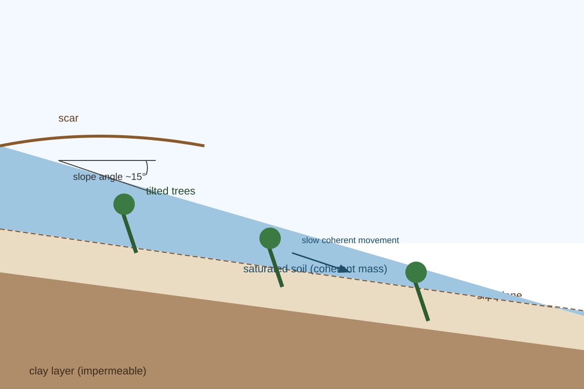
Generated figure for Q3.
4. Give one example of a regulating ecosystem service provided by a tropical forest. [1]
5. State one natural input and one natural output in a tropical drainage basin hydrological system. [2]
Input: ___________________________
Output: ___________________________
6. According to the syllabus, what is the key distinguishing climatic characteristic of all tropical climate zones? [1]
7. Name the phase of the El Niño Southern Oscillation (ENSO) associated with reduced rainfall over the western tropical Pacific. [1]
8. Identify the chemical weathering process in which carbon dioxide dissolved in rainwater forms a weak acid that dissolves limestone. [1]
9. State the term used for water that flows slowly through the soil zone to a river via throughflow and eventually as baseflow. [1]
10. Name one human activity that can compromise provisioning ecosystem services in a tropical catchment. [1]
Section B: Explanation and Application (Questions 11–15)
11. Explain two ways in which high temperatures influence the hydrological cycle in the humid tropics. [4]
12. Using the resource below, describe the vegetation structure and mean biomass of a typical tropical rainforest as shown. [3]
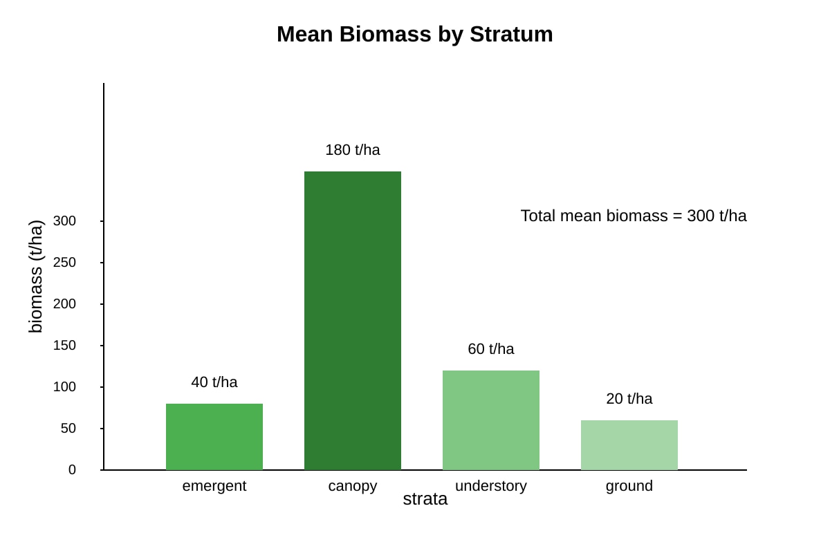
Generated graph for Q12.
13. Explain how monsoon circulations in humid tropical Asia produce a seasonal rainfall peak. [4]
14. A drainage basin has the following annual water balance (mm): precipitation 2000, evapotranspiration 1200, change in storage +100. Calculate the river discharge in mm. Show your working. [3]
Working: __________________________________________________
Answer: ___________________________ mm
15. Explain how deforestation in a tropical drainage basin can increase the risk of fluvial flooding downstream. [5]
Section C: Analysis, Evaluation, and Interpretation (Questions 16–20)
16. The graph below shows monthly rainfall for Station X (humid tropics). Using the data, identify the climate type (Af, Am, or Aw) and give two pieces of evidence from the graph to support your answer. [5]
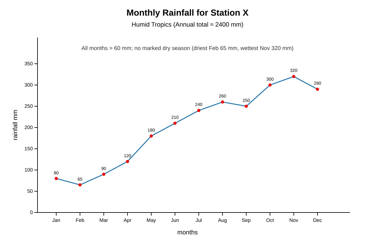
Generated graph for Q16.
Climate type: ___________________________
Evidence 1: __________________________________________________
Evidence 2: __________________________________________________
17. Explain the processes of chemical weathering that lead to the formation of a karst landscape in tropical limestone regions. [7]
18. Study the map extract below showing a tropical river basin. Identify two natural factors and two human factors that could increase fluvial flood risk in the basin. [4]
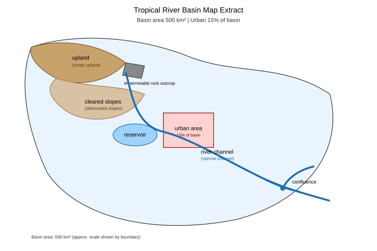
Generated map for Q18.
Natural 1: ___________________________ Natural 2: ___________________________
Human 1: ___________________________ Human 2: ___________________________
19. To what extent can hard-engineering strategies (e.g. levees, dams) fully control fluvial flooding in the humid tropics? Evaluate with reference to limitations. [6]
20. The diagram below shows a tropical drainage basin with labelled stores and flows. Name two stores and two flows, and explain how a prolonged drought would alter the relationship between them. [8]
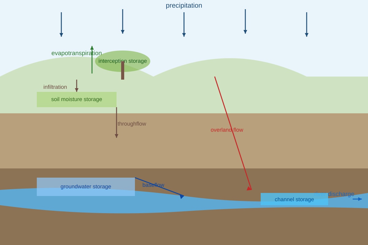
Generated diagram for Q20.
Stores: (a) __________________ (b) __________________
Flows: (c) __________________ (d) __________________
Explanation: __________________________________________________