AI Generated Quiz
A Level H2 Geography Physical Geography Quiz
Free A Level H2 Geography Physical Geography quiz, AI version, with questions, answers, and A Level-style practice for Singapore students.
These static practice materials are generated from the site's syllabus and paper-generation workflow, with source and model context shown so students and parents can evaluate the material before use.
Questions
Free quiz and exam paper access
Enter your details to view this paper
Your access is remembered on this device.
Answers
A-Level Geography H2 Quiz - Physical Geography: Answer Key
Total Marks: 50
Section A: Tropical Climates and Drainage Basins (Questions 1–10)
Question 1 [1 mark]
Answer: High temperatures throughout the year (mean monthly temperatures consistently above 18°C).
Explanation: The key distinguishing characteristic of all tropical climate zones is consistently high temperatures. Unlike temperate regions that experience distinct seasonal temperature variations, the tropics receive intense solar radiation year-round due to the sun's high angle of incidence. This results in mean monthly temperatures that remain above 18°C in all months, even in the driest tropical climates. The primary variation between tropical climate zones is in rainfall amount and seasonality, not temperature.
Marking Note: Accept "consistently high temperatures" or "mean monthly temperature above 18°C all year." Do not accept "hot and wet" as this confuses temperature with precipitation.
Question 2 [3 marks]
Answer: The seasonal migration of the Hadley cell influences rainfall patterns in the humid tropics through the movement of the Intertropical Convergence Zone (ITCZ). The Hadley cell is a large-scale atmospheric circulation pattern where warm, moist air rises near the equator, cools, and releases precipitation. As the sun's direct rays shift north and south of the equator during the year, the ITCZ (the zone where the trade winds converge) migrates correspondingly. This migration brings a period of heavy rainfall (wet season) to areas when the ITCZ is overhead, and a drier period when the ITCZ moves away. Regions near the equator experience two wet seasons as the ITCZ passes over twice annually, while areas further from the equator experience one distinct wet season and one dry season.
Marking Scheme:
- 1 mark: Explains that the Hadley cell/ITCZ migrates seasonally following the sun's direct rays
- 1 mark: Describes how rising air at the ITCZ causes condensation and rainfall
- 1 mark: Links migration to seasonal rainfall patterns (e.g., wet season when ITCZ is overhead, dry season when it moves away)
Common Mistake: Students often confuse the Hadley cell with the Walker circulation or describe only the general circulation without linking it to seasonal rainfall patterns.
Question 3 [2 marks]
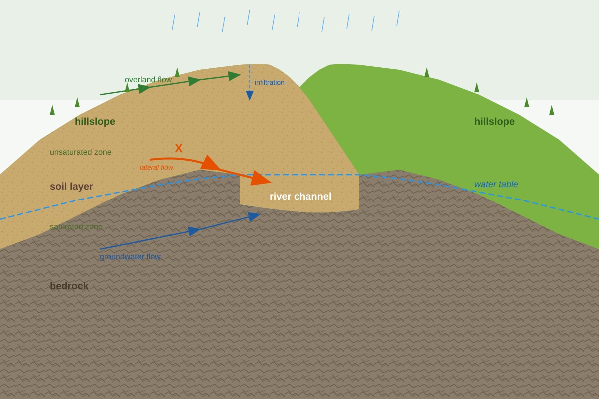
Answer: Pathway X is throughflow. Throughflow is the lateral movement of water through the soil layer, above the water table, towards the river channel. It occurs when water infiltrates into the soil and then moves downslope through the soil pores and spaces, eventually reaching the river channel or contributing to groundwater recharge.
Explanation: In a drainage basin, water moves through various pathways. Throughflow is distinct from overland flow (water moving across the surface) and groundwater flow/baseflow (water moving through the saturated zone below the water table). Throughflow occurs in the unsaturated zone of the soil, where water moves laterally through soil pores, root channels, and other spaces. It is a slower process than overland flow but faster than groundwater flow. Throughflow contributes to the delayed flow component of a river's discharge following a rainfall event.
Marking Scheme:
- 1 mark: Correctly identifies the pathway as throughflow
- 1 mark: Describes its role (lateral movement of water through soil towards river channel)
Question 4 [2 marks]
Answer: Two human factors that can increase the risk of fluvial flooding in the humid tropics:
-
Urbanisation: The construction of impermeable surfaces (roads, buildings, car parks) reduces infiltration and increases surface runoff. This leads to higher peak discharges and shorter lag times during storm events, increasing flood risk.
-
Deforestation: Removal of forest cover reduces interception storage and evapotranspiration. It also reduces soil infiltration capacity as root systems decay and soil structure degrades. This increases the volume and speed of surface runoff reaching rivers.
Explanation: Fluvial flooding occurs when river discharge exceeds channel capacity. Human activities in the drainage basin can significantly alter the hydrological response to rainfall. Urbanisation replaces permeable surfaces with impermeable ones, preventing water from infiltrating into the soil. Deforestation removes the vegetation that intercepts rainfall and the root systems that maintain soil structure and infiltration capacity. Both factors increase the proportion of rainfall that becomes surface runoff, leading to higher and more rapid flood peaks.
Marking Scheme:
- 1 mark for each valid human factor with a brief explanation (2 marks total)
- Accept other valid factors such as: drainage of wetlands, river channel modification, agricultural practices (compaction, ploughing), or construction on floodplains
Question 5 [3 marks]
Answer: During the El Niño phase of ENSO, the trade winds weaken or reverse direction over the tropical Pacific Ocean. This causes the warm pool of water that normally accumulates in the western Pacific (near Indonesia and Australia) to shift eastward towards the central and eastern Pacific. As a result:
- The western Pacific (Indonesia, Australia, Southeast Asia) experiences below-average rainfall and drought conditions because the warm water and associated convection (rising air) have moved eastward.
- The central and eastern Pacific (including the west coast of South America) experiences above-average rainfall and flooding because the warm water and convection are now located there.
Explanation: ENSO (El Niño Southern Oscillation) is a natural climate phenomenon involving interactions between the ocean and atmosphere in the tropical Pacific. In normal (neutral) conditions, strong trade winds push warm surface water westward, allowing cold, nutrient-rich water to upwell along the South American coast. During El Niño, these trade winds weaken, allowing warm water to flow back eastward. This shift in sea surface temperatures changes the location of atmospheric convection, dramatically altering rainfall patterns across the tropical Pacific region.
Marking Scheme:
- 1 mark: Describes the weakening/reversal of trade winds
- 1 mark: Explains the shift of warm water and convection eastward
- 1 mark: Describes the resulting rainfall changes (drought in west, flooding in east)
Common Mistake: Students often confuse El Niño with La Niña or describe only one side of the rainfall changes. A complete answer must address both the western and eastern Pacific.
Question 6 [3 marks]
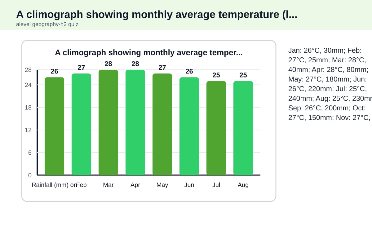
Answer: The climate shown in Resource 2 is classified as Tropical Savanna (Aw) under the Köppen-Geiger system.
Justification:
- The mean monthly temperature remains above 18°C throughout the year (24°C–28°C), satisfying the tropical climate criterion.
- There is a distinct dry season: 4 months (January–April) have rainfall below 60mm per month, which is the threshold for the dry season in tropical climates.
- The dry season occurs during the low-sun period (winter months), which is characteristic of the Aw climate type.
Explanation: The Köppen-Geiger classification system categorises tropical climates based on temperature and rainfall patterns. The Aw (Tropical Savanna) climate is distinguished from Af (Tropical Rainforest) by having a distinct dry season. The standard criterion is that the driest month receives less than 60mm of precipitation. In this climograph, the dry season is clearly visible from January to April, with rainfall well below 60mm, while the wet season (May–September) receives abundant rainfall. This seasonal pattern is typical of tropical savanna regions.
Marking Scheme:
- 1 mark: Correctly identifies Aw (Tropical Savanna)
- 1 mark: References the temperature criterion (all months above 18°C)
- 1 mark: References the dry season criterion (at least one month with <60mm rainfall)
Common Mistake: Students may classify this as Am (Tropical Monsoon) if they see a seasonal pattern, but Am typically has a shorter dry season and very high rainfall in the wet season. The clear 4-month dry season here is more characteristic of Aw.
Question 7 [2 marks]
Answer: Interception storage is water that is temporarily held on the surfaces of vegetation (leaves, branches, stems) after precipitation, before it reaches the ground. This water is either evaporated directly back into the atmosphere or drips/flows down to the ground surface.
Soil moisture storage is water held within the soil pores in the unsaturated zone, above the water table. This water is available for plant uptake and can be lost through evapotranspiration or move laterally as throughflow.
Explanation: These are two different types of storage in the drainage basin hydrological cycle. Interception storage is a temporary, above-ground store that depends on vegetation type, density, and the intensity of rainfall. Soil moisture storage is a below-ground store that depends on soil texture, structure, depth, and organic matter content. The key distinction is location: interception storage is on vegetation surfaces, while soil moisture storage is within the soil matrix.
Marking Scheme:
- 1 mark: Correctly defines interception storage
- 1 mark: Correctly defines soil moisture storage
- Accept clear distinction between above-ground (vegetation) and below-ground (soil) storage
Question 8 [4 marks]
Answer: Tropical cyclones develop over warm tropical oceans when specific atmospheric and surface conditions are met:
Atmospheric conditions required:
- Sea surface temperature (SST) above 26.5°C: Warm water provides the heat and moisture needed to fuel the cyclone. The warm water evaporates, providing latent heat energy when the water vapour condenses.
- High humidity in the lower and middle troposphere: Moist air allows for continued condensation and release of latent heat, which powers the storm.
- Low vertical wind shear: Wind speed and direction must not change significantly with height. Strong wind shear would disrupt the vertical structure of the developing storm.
- Location at least 5° from the equator: The Coriolis effect is needed to initiate rotation. Near the equator, the Coriolis effect is too weak.
Development process: Warm, moist air rises from the ocean surface, creating an area of low pressure. As air rises, it cools and condenses, releasing latent heat. This heats the surrounding air, causing more air to rise. The Coriolis effect causes the rising air to rotate, forming a cyclonic circulation. As more warm, moist air is drawn into the system, the cyclone intensifies, with a well-defined eye forming at the centre.
Marking Scheme:
- 1 mark: States SST above 26.5°C as a requirement
- 1 mark: States low vertical wind shear and/or location away from equator
- 1 mark: Describes the process of warm air rising, condensation, and latent heat release
- 1 mark: Describes the role of the Coriolis effect in initiating rotation
Common Mistake: Students often list conditions without explaining the process, or they confuse tropical cyclones with other weather systems like monsoon depressions.
Question 9 [3 marks]
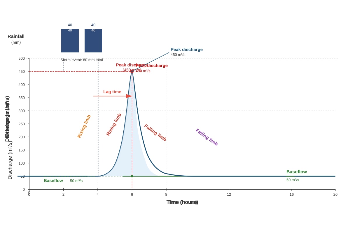
Answer: The hydrograph shows a flashy response to the storm event, characterised by:
- A steep rising limb, indicating rapid runoff reaching the river
- A high peak discharge (450 m³/s) relative to baseflow (50 m³/s)
- A short lag time (3 hours) between peak rainfall and peak discharge
- A moderately steep falling limb
Two factors that could have influenced this hydrograph shape:
- Intense rainfall: The storm delivered 80mm of rainfall in just 2 hours, which is a high-intensity event. This exceeds the infiltration capacity of the soil, generating rapid overland flow (Hortonian overland flow) that quickly reaches the river channel.
- Urbanised or impermeable catchment: If the drainage basin has a high proportion of impermeable surfaces (urban areas) or compacted soils, infiltration is limited, and surface runoff is generated quickly, producing a flashy hydrograph with a short lag time and high peak discharge.
Explanation: A storm hydrograph shows how a river responds to a rainfall event. The shape is influenced by both natural factors (rainfall intensity, soil type, vegetation cover, basin size and shape) and human factors (urbanisation, deforestation, drainage modifications). A flashy hydrograph with a steep rising limb and short lag time indicates that water is reaching the river quickly, which increases flood risk.
Marking Scheme:
- 1 mark: Describes the hydrograph shape (steep rising limb, short lag time, high peak)
- 2 marks: Suggests two valid factors with explanation (1 mark each)
- Accept other valid factors: steep slopes, saturated soil, deforestation, drainage network density, soil type (clay soils)
Question 10 [5 marks]
Answer: Humans have a limited and partial ability to control fluvial flooding in the humid tropics. While various management strategies exist, their effectiveness is constrained by the scale and intensity of natural processes, as well as economic and social factors.
Arguments that humans can control flooding:
- Structural measures: Engineering solutions such as dams, levees, and flood walls can contain river channels and store excess floodwater. For example, the Three Gorges Dam in China has reduced flood risk along the Yangtze River.
- Channel modification: Straightening, deepening, and widening river channels can increase channel capacity and reduce flood risk.
- Flood forecasting and warning systems: Advanced monitoring and prediction allow for early warning and evacuation, reducing loss of life and property damage.
- Land-use planning: Zoning regulations can restrict development on floodplains, reducing vulnerability.
Arguments that control is limited:
- Extreme rainfall events: The humid tropics experience intense, prolonged rainfall from monsoon systems and tropical cyclones that can overwhelm even well-designed flood defences. Climate change is increasing the frequency and intensity of such events.
- Cost and feasibility: Large-scale structural measures are extremely expensive and may not be affordable for developing countries in the tropics. They also require ongoing maintenance.
- Environmental impacts: Dams and channel modifications can have negative ecological impacts, including disrupting sediment transport and fish migration.
- Uncertainty and limits of prediction: Flood forecasting has limitations, and extreme events can exceed design specifications of flood defences.
- Human factors: Rapid urbanisation and population growth in tropical floodplains increase vulnerability and make control more difficult.
Conclusion: Humans can reduce the frequency and severity of flooding through a combination of structural and non-structural measures, but cannot completely control or eliminate flood risk, especially in the face of extreme events and climate change. A sustainable approach combines engineering solutions with ecosystem-based adaptation and community preparedness.
Marking Scheme (Levels-based):
- Level 3 (4–5 marks): Balanced evaluation with clear arguments for and against, supported by specific examples. Shows understanding of the limitations of human control. Clear conclusion.
- Level 2 (2–3 marks): Describes some management strategies but limited evaluation of their effectiveness. May be one-sided.
- Level 1 (0–1 mark): Simple listing of flood control methods without evaluation or understanding of limitations.
Section B: Landforms in the Tropics (Questions 11–20)
Question 11 [2 marks]
Answer: Weathering is the breakdown and alteration of rocks and minerals at or near the Earth's surface through physical, chemical, or biological processes, occurring in situ (without movement).
Erosion is the removal and transportation of weathered material by agents such as water, wind, ice, or gravity.
Distinction: Weathering breaks down rock in place, while erosion involves the movement of the broken-down material from its original location.
Explanation: This is a fundamental distinction in geomorphology. Weathering prepares material for erosion by breaking it into smaller pieces or altering its chemical composition. Erosion then transports this material away. The key difference is movement: weathering occurs without transport, while erosion inherently involves transport. For example, freeze-thaw weathering breaks rock into fragments, but it is only when those fragments are carried away by a river (erosion) that the landscape is lowered.
Marking Scheme:
- 1 mark: Correct definition of weathering (in situ breakdown)
- 1 mark: Correct definition of erosion (removal and transport) and clear distinction
Question 12 [2 marks]
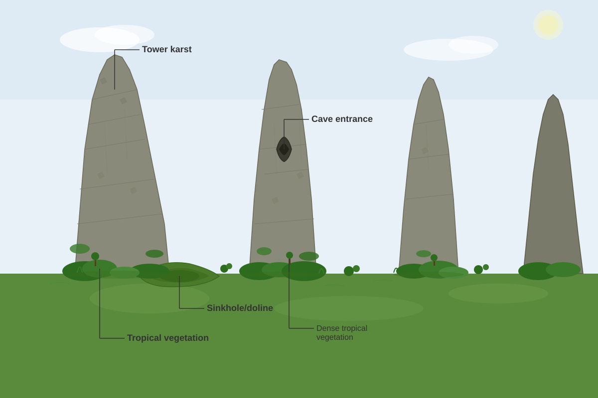
Answer: Two surface landforms visible in the photograph:
- Tower karst (also called cockpit karst or mogotes) – the steep-sided, tower-like limestone hills
- Sinkhole/doline – the depression at the base of one of the hills
Explanation: Karst landscapes form in soluble carbonate rocks like limestone. In the humid tropics, intense chemical weathering (carbonation and solution) creates distinctive landforms. Tower karst consists of isolated, steep-sided hills that rise abruptly from a flat plain. These are remnants of the original limestone surface that have not been fully dissolved. Sinkholes (dolines) are enclosed depressions formed by the dissolution of limestone at the surface or by the collapse of underlying cave roofs. The photograph shows both features, which are characteristic of tropical karst landscapes.
Marking Scheme:
- 1 mark for each correctly identified landform (2 marks total)
- Accept other valid landforms: cave entrance, limestone pavement, grikes/clints (if visible)
Question 13 [3 marks]
Answer: Carbonation is a chemical weathering process that affects rocks containing calcium carbonate (CaCO₃), such as limestone and marble.
Process:
- Rainwater absorbs carbon dioxide (CO₂) from the atmosphere and from the soil (where it is produced by decomposing organic matter and root respiration).
- The CO₂ dissolves in the rainwater to form weak carbonic acid (H₂CO₃): H₂O + CO₂ → H₂CO₃
- This weak acid reacts with calcium carbonate in the limestone: CaCO₃ + H₂CO₃ → Ca(HCO₃)₂ (calcium bicarbonate)
- Calcium bicarbonate is soluble in water and is removed in solution, gradually dissolving the limestone.
Explanation: Carbonation is particularly effective in tropical environments because:
- High temperatures increase the rate of chemical reactions (the rate approximately doubles for every 10°C rise in temperature).
- Abundant rainfall provides a continuous supply of water and dissolved CO₂.
- Dense vegetation in the tropics produces large amounts of CO₂ in the soil through decomposition.
Marking Scheme:
- 1 mark: Identifies the reactants (water + CO₂ → carbonic acid)
- 1 mark: Describes the reaction with calcium carbonate to form soluble calcium bicarbonate
- 1 mark: Explains why this process is effective in tropical environments (temperature, rainfall, vegetation)
Common Mistake: Students often write the equation incorrectly or omit the role of CO₂, thinking that water alone dissolves limestone.
Question 14 [2 marks]
Answer: Pressure release (also called sheeting or exfoliation) is a physical weathering process that occurs when overlying rock is removed by erosion, reducing the pressure on the underlying rock. The rock expands and fractures parallel to the surface, creating sheet-like joints or exfoliation sheets.
In tropical environments, pressure release is common in areas of:
- Deep weathering profiles where thick layers of weathered material are removed
- Steep slopes where rapid erosion exposes fresh rock surfaces
- Granitic landscapes where the rock is massive and homogeneous
Explanation: Rocks deep underground are under immense pressure from the weight of overlying material. When this overburden is removed by erosion, the rock expands. This expansion creates tensional stresses that cause the rock to fracture along planes parallel to the surface. These fractures are called sheet joints. In tropical environments, deep weathering profiles can develop due to intense chemical weathering, and when these are eroded, the underlying fresh rock is exposed to pressure release.
Marking Scheme:
- 1 mark: Explains the process (removal of overburden → expansion → fracturing)
- 1 mark: Provides a relevant example or context in tropical environments
Question 15 [3 marks]
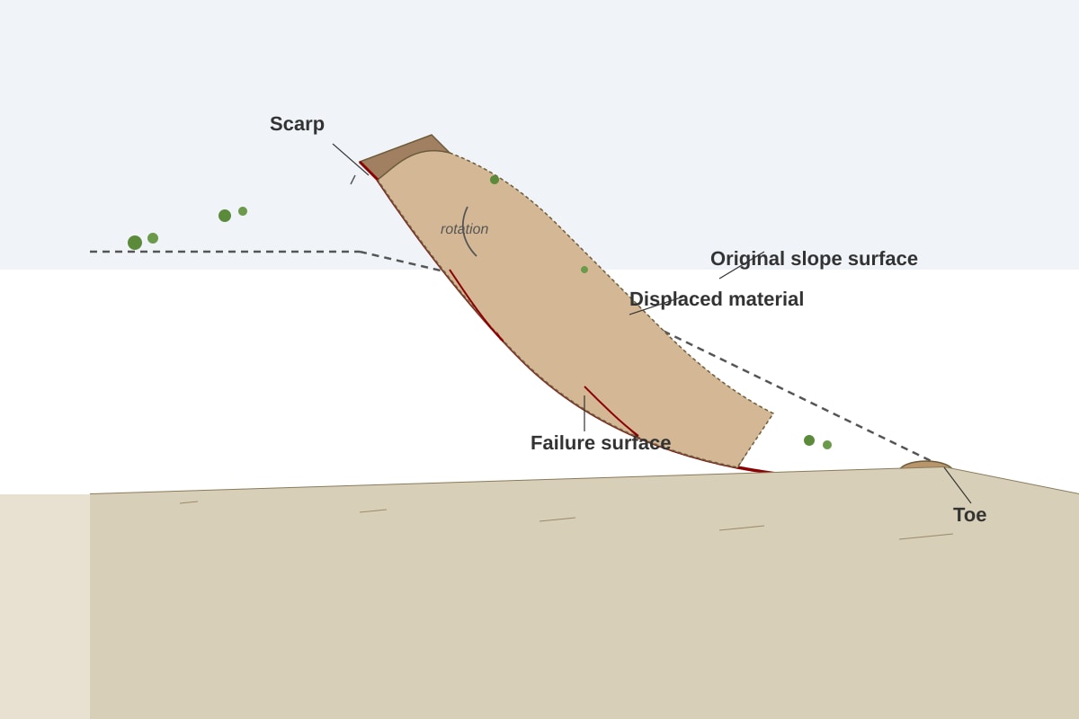
Answer: The mass movement shown is a rotational slide (also called a slump).
Characteristics:
- The failure surface is curved and concave upwards (spoon-shaped).
- The displaced material moves along this curved surface, rotating backwards as it slides.
- A distinct scarp (steep, curved cliff) forms at the top of the slide where the material has pulled away.
- The toe of the slide is where the displaced material accumulates at the base of the slope.
- The movement is relatively slow compared to rockfalls or debris flows.
Explanation: Rotational slides are a type of mass movement where a block of material moves downslope along a curved failure plane. The rotation occurs because the centre of gravity of the moving block shifts as it slides. This type of mass movement is common in:
- Areas with thick, homogeneous soil or clay
- Slopes where the base has been undercut (by river erosion, road construction, or wave action)
- Humid tropical regions where intense rainfall saturates the soil, reducing shear strength
Marking Scheme:
- 1 mark: Correctly identifies rotational slide/slump
- 1 mark: Describes the curved failure surface and rotation
- 1 mark: Describes at least one other characteristic (scarp, toe, slow movement)
Common Mistake: Students may confuse rotational slides with translational slides (which move along a planar failure surface) or with flows (which involve fluid-like movement).
Question 16 [3 marks]
Answer: Splash erosion is the first stage of water erosion. When raindrops hit the bare soil surface, their kinetic energy detaches soil particles and splashes them into the air. These particles can be moved short distances (up to 1.5 metres horizontally). Splash erosion is particularly effective in the tropics due to the high intensity of rainfall, which produces large raindrops with high kinetic energy.
Rillwash occurs when surface runoff concentrates into small, shallow channels called rills. The flowing water in these rills detaches and transports soil particles downslope. Rillwash is more effective than splash erosion at transporting material over longer distances because the flowing water has both the energy to detach particles and the capacity to carry them.
Relationship: Splash erosion detaches soil particles and makes them available for transport by surface runoff. Rillwash then transports these particles downslope, gradually enlarging the rills through further erosion. Together, they can remove significant amounts of soil from tropical hillslopes, especially where vegetation cover has been removed.
Explanation: These are two related but distinct processes in water erosion. Splash erosion is caused by raindrop impact, while rillwash is caused by flowing water. In the humid tropics, intense rainfall events can generate both processes rapidly. The removal of forest cover for agriculture or logging exposes the soil to raindrop impact, initiating splash erosion. As surface runoff develops, rills form and rillwash becomes the dominant erosion process.
Marking Scheme:
- 1 mark: Explains splash erosion (raindrop impact detaching soil particles)
- 1 mark: Explains rillwash (concentrated flow in small channels)
- 1 mark: Describes the relationship between the two processes
Question 17 [3 marks]
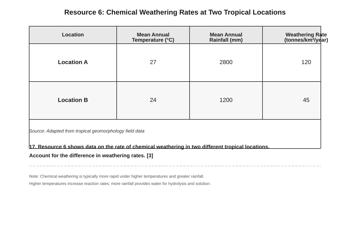
Answer: The difference in chemical weathering rates between Location A (120 tonnes/km²/year) and Location B (45 tonnes/km²/year) can be accounted for by differences in temperature and rainfall:
Temperature: Location A has a higher mean annual temperature (27°C) compared to Location B (24°C). Chemical reaction rates approximately double for every 10°C increase in temperature (the Van't Hoff rule). The higher temperature at Location A increases the rate of chemical weathering reactions such as hydrolysis, carbonation, and oxidation.
Rainfall: Location A receives more than double the annual rainfall (2800mm) compared to Location B (1200mm). Water is essential for chemical weathering as it:
- Provides the medium for chemical reactions
- Supplies dissolved CO₂ for carbonation
- Removes soluble weathering products, maintaining the concentration gradient that drives further weathering
- Supports vegetation growth, which produces organic acids and CO₂ in the soil
Combined effect: The higher temperature and much higher rainfall at Location A create more favourable conditions for chemical weathering, resulting in a weathering rate nearly three times higher than at Location B.
Explanation: Chemical weathering rates in the tropics are strongly controlled by climate, particularly temperature and precipitation. The combination of high temperatures and abundant rainfall creates optimal conditions for chemical reactions. This is why chemical weathering is generally more intense in the humid tropics than in any other climatic zone.
Marking Scheme:
- 1 mark: References the temperature difference and its effect on reaction rates
- 1 mark: References the rainfall difference and its role in weathering
- 1 mark: Explains the combined effect of both factors
Common Mistake: Students may describe the difference without explaining the mechanisms by which temperature and rainfall affect weathering rates.
Question 18 [2 marks]
Answer: Corrosion (also called solution) is a type of fluvial erosion where the river water chemically dissolves soluble minerals from the river bed and banks. The water, often containing dissolved CO₂ (forming weak carbonic acid), reacts with soluble rocks such as limestone, chalk, or dolomite, dissolving the calcium carbonate and carrying it away in solution.
Explanation: Corrosion is distinct from other fluvial erosion processes:
- Corrasion (abrasion): physical wearing away by sediment carried in the water
- Attrition: particles colliding and breaking into smaller pieces
- Hydraulic action: force of water entering cracks and joints
Corrosion is a chemical process rather than a physical one. It is most effective in rivers flowing over soluble rocks and in areas where the water is slightly acidic. In tropical environments, warm temperatures and abundant organic matter in the water can increase the rate of corrosion.
Marking Scheme:
- 1 mark: Correctly identifies corrosion as chemical dissolution
- 1 mark: Explains the process (water + CO₂ → acid → dissolves soluble minerals)
Question 19 [4 marks]
Answer: Human activities can accelerate the rate of mass movement in tropical environments through several mechanisms:
-
Deforestation: Removal of forest cover eliminates the root systems that bind soil together and provide slope stability. Roots act as natural reinforcement, increasing the shear strength of the soil. Without roots, the soil is more prone to failure, especially when saturated by heavy rainfall. Deforestation also reduces evapotranspiration, leading to higher soil moisture content.
-
Road construction and excavation: Cutting into slopes for roads, buildings, or mining creates steep, unstable slopes (cut slopes) that are more prone to failure. The removal of support at the base of a slope (undercutting) reduces the resisting force and can trigger landslides. Road construction also often involves the disposal of excavated material on slopes, creating unstable fill slopes.
-
Agricultural practices: Ploughing on steep slopes, particularly when done parallel to the slope (rather than along contours), can destabilise the soil. Irrigation can increase soil moisture content, reducing shear strength and increasing the likelihood of failure. Overgrazing removes vegetation cover and compacts the soil.
-
Urbanisation: The addition of buildings and infrastructure adds weight to slopes, increasing the driving force for mass movement. Leaking water pipes and septic systems can saturate the soil, reducing its strength. Changes to drainage patterns can concentrate water flow onto slopes.
Explanation: Mass movement occurs when the driving forces (gravity, weight of material) exceed the resisting forces (shear strength of the material). Human activities can increase driving forces (adding weight, steepening slopes) or decrease resisting forces (removing vegetation, saturating soil). In the humid tropics, where rainfall is abundant and slopes are often steep, these human modifications can significantly increase the risk of landslides and other mass movements.
Marking Scheme:
- 1 mark for each valid human activity with clear explanation of how it accelerates mass movement (4 marks total)
- Accept other valid activities: mining, quarrying, drainage modification, construction of reservoirs, blasting/vibration
Question 20 [5 marks]
Answer: I agree to a moderate extent that geomorphic processes in the tropics are primarily controlled by climate, but human activity has become an increasingly significant factor, particularly in recent decades.
Arguments that climate is the primary control:
- Temperature and rainfall intensity: The high temperatures and abundant rainfall of the humid tropics create optimal conditions for chemical weathering (hydrolysis, carbonation, oxidation). Chemical weathering rates in the tropics are among the highest in the world, directly controlled by climatic factors.
- Rainfall regime: The seasonal distribution of rainfall controls the timing and intensity of fluvial erosion and mass movement. Intense monsoon rains trigger landslides and generate high river discharge capable of significant erosion and transport.
- Tropical cyclone activity: These extreme weather events, controlled by sea surface temperatures and atmospheric circulation, can cause catastrophic erosion and mass movement in a short period.
- Vegetation-climate feedback: Climate determines the type and density of vegetation, which in turn influences weathering rates, soil development, and slope stability.
Arguments that human activity is increasingly significant:
- Land-use change: Deforestation for agriculture, logging, and urbanisation has dramatically altered geomorphic processes. In many tropical regions, human-induced erosion rates now exceed natural rates by orders of magnitude.
- Accelerated weathering: Air pollution (acid rain) can accelerate chemical weathering rates beyond natural levels.
- Direct modification of slopes: Road construction, mining, and urban development create unstable slopes and trigger mass movements that would not occur naturally.
- Climate change: Human-induced climate change is altering rainfall patterns, increasing the intensity of extreme events, and potentially changing the frequency and magnitude of geomorphic processes.
Conclusion: While climate remains the fundamental control on the type and rate of geomorphic processes in the tropics, human activity has become a significant modifying factor. In many areas, particularly those with intensive land use, human activities may now be the dominant control on local geomorphic processes. The extent of human influence varies spatially, being most pronounced in densely populated and intensively developed areas.
Marking Scheme (Levels-based):
- Level 3 (4–5 marks): Balanced evaluation with clear arguments for both climate and human control. Uses specific examples and shows understanding of spatial and temporal variations. Clear, reasoned conclusion.
- Level 2 (2–3 marks): Describes both climate and human factors but limited evaluation of their relative importance. May be one-sided or lack specific examples.
- Level 1 (0–1 mark): Simple statement of agreement or disagreement without reasoned argument or examples.
End of Answer Key