AI Generated Quiz
A Level H2 Geography Physical Geography Quiz
Free A Level H2 Geography Physical Geography quiz, AI version, with questions, answers, and A Level-style practice for Singapore students.
These static practice materials are generated from the site's syllabus and paper-generation workflow, with source and model context shown so students and parents can evaluate the material before use.
Questions
Free quiz and exam paper access
Enter your details to view this paper
Your access is remembered on this device.
Answers
A-Level Geography H2 Quiz - Physical Geography: Answer Key
Total Marks: 50
Section A: Tropical Climates and Drainage Basins (Questions 1-5)
Question 1 (5 marks)
(a) State two key distinguishing characteristics of tropical climates. [2]
Answer:
- High temperatures throughout the year (mean monthly temperatures are consistently high, typically above 18°C).
- Distinct seasonality of rainfall (either a wet-dry pattern or consistently high rainfall), rather than temperature variation.
Teaching Notes:
- The key point is that temperature variation is minimal in the tropics. The seasons are defined by rainfall, not temperature.
- Students often mistakenly say "high rainfall" as a defining characteristic. While many tropical areas have high rainfall, some (like tropical deserts) are dry. The distinguishing feature is the lack of a cold season.
- Marking: Award 1 mark for each correct characteristic. Accept "high temperatures year-round" and "rainfall seasonality" or similar.
(b) Explain how the seasonal migration of the Hadley cell influences rainfall patterns in the humid tropics. [3]
Answer: The Hadley cell is a global atmospheric circulation pattern where warm air rises near the equator, moves poleward at high altitude, descends in the subtropics, and returns to the equator at the surface. The Intertropical Convergence Zone (ITCZ), where the trade winds converge and air rises, is located within the rising limb of the Hadley cell.
The ITCZ migrates seasonally, following the thermal equator (the area of maximum solar heating). This migration causes:
- Regions near the equator to experience two rainfall maxima as the ITCZ passes over them twice a year.
- Regions further from the equator to experience one distinct wet season when the ITCZ is overhead and a dry season when it is not.
Teaching Notes:
- Think of the ITCZ as a "rain belt" that moves north and south with the seasons.
- The rising air in the ITCZ cools adiabatically, leading to condensation and precipitation.
- The descending air in the subtropical high-pressure zones (around 30°N and 30°S) is dry, creating the world's major deserts.
- Marking: Award 1 mark for explaining the Hadley cell/ITZC mechanism, 1 mark for describing seasonal migration, and 1 mark for linking to rainfall patterns.
Question 2 (7 marks)
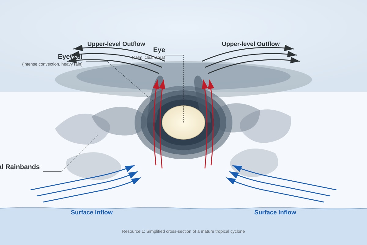
(a) Identify the atmospheric and surface conditions required for the development of a tropical cyclone. [3]
Answer:
- Sea surface temperature must be at least 26.5°C to a depth of about 50m, providing sufficient heat and moisture.
- High humidity in the lower to mid-troposphere, allowing deep convection to develop.
- Low vertical wind shear (little change in wind speed and direction with height), allowing the storm to remain vertically organized.
- Location at least 5° from the equator to provide sufficient Coriolis force for rotation.
- A pre-existing disturbance (e.g., a tropical wave) to initiate convection.
Teaching Notes:
- The warm ocean provides the energy source. As warm, moist air rises, water vapor condenses, releasing latent heat, which further fuels the storm.
- The Coriolis force is essential for rotation; it is too weak within 5° of the equator.
- High wind shear would "tear apart" the vertical structure of the storm.
- Marking: Award 1 mark for each of three correct conditions with brief explanation. Accept any three of the five listed.
(b) Explain how the El Niño Southern Oscillation (ENSO) can influence the frequency and intensity of tropical cyclones in the Pacific Ocean. [4]
Answer: ENSO has three phases: El Niño, La Niña, and Neutral.
-
El Niño: Warmer-than-average sea surface temperatures in the central and eastern Pacific, and cooler in the western Pacific. This shifts the region of deep convection eastward. The result is reduced tropical cyclone formation in the western Pacific (e.g., near Australia and Southeast Asia) but increased activity in the central and eastern Pacific. The stronger vertical wind shear in the western Pacific also inhibits cyclone development.
-
La Niña: Cooler-than-average sea surface temperatures in the central and eastern Pacific, and warmer in the western Pacific. This enhances convection in the western Pacific, leading to increased tropical cyclone formation in this region. Reduced wind shear in the western Pacific further favors development.
-
Neutral: Conditions are closer to average, with tropical cyclone activity occurring in the typical regions.
Teaching Notes:
- The key mechanism is the shift in the location of warm ocean water and associated convection.
- Students often confuse the effects. Remember: La Niña = more cyclones in the western Pacific (where Singapore is); El Niño = fewer cyclones in the western Pacific.
- Marking: Award 1 mark for identifying the three phases, 1 mark for explaining the El Niño effect, 1 mark for explaining the La Niña effect, and 1 mark for linking to changes in sea surface temperature and wind shear.
Question 3 (6 marks)
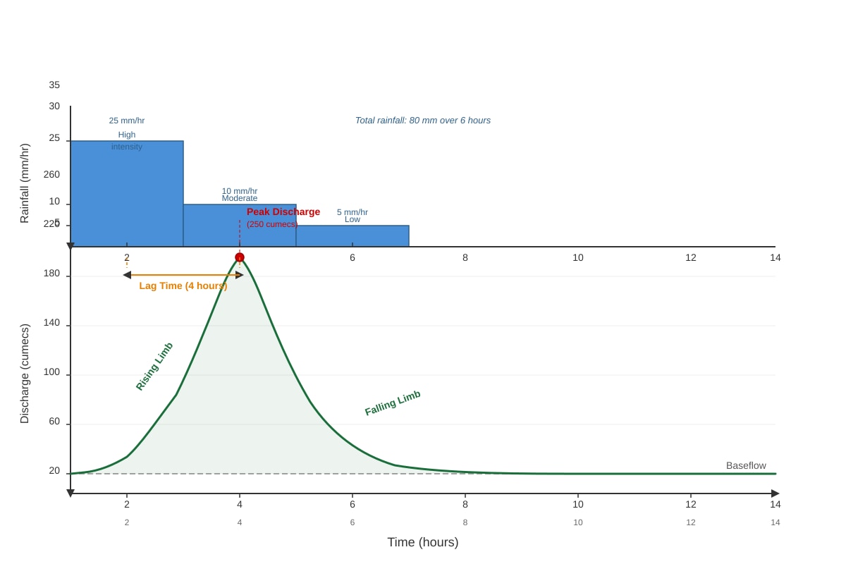
(a) Describe the shape of the hydrograph shown in Resource 2. [2]
Answer: The hydrograph shows a steep rising limb, indicating a rapid increase in discharge following the rainfall event. It reaches a high peak discharge of 250 cumecs. The falling limb is initially steep but then becomes more gradual as the discharge returns to baseflow. The lag time is short (4 hours).
Teaching Notes:
- A hydrograph shows how a river responds to a rainfall event.
- The rising limb shows the speed of the river's response. A steep rising limb means the water reached the channel quickly.
- The peak discharge is the maximum flow.
- The falling limb shows how quickly the water drains from the basin.
- Marking: Award 1 mark for describing the steep rising limb and high peak, and 1 mark for describing the short lag time and the shape of the falling limb.
(b) Explain how two natural factors could have contributed to the short lag time and high peak discharge shown. [4]
Answer: Two natural factors that could contribute to a short lag time and high peak discharge are:
-
High rainfall intensity: The rainfall data shows high intensity in the first 2 hours. Intense rainfall exceeds the infiltration capacity of the soil, leading to rapid overland flow (Hortonian overland flow). This water reaches the channel quickly, producing a steep rising limb and high peak.
-
Steep slopes: A basin with steep slopes will have faster overland flow and throughflow velocities. Water moves downhill more rapidly under gravity, reducing the time it takes to reach the river channel. This results in a shorter lag time and a higher, more concentrated peak discharge.
-
Saturated soil: If the soil was already saturated from previous rainfall, there is no capacity for additional infiltration. All subsequent rainfall becomes overland flow (saturation overland flow), rapidly increasing river discharge.
-
High drainage density: A basin with many streams and tributaries will collect and convey water to the main channel more efficiently, reducing lag time.
Teaching Notes:
- Lag time is the time difference between the peak rainfall and the peak discharge.
- A short lag time means the basin responds quickly to rainfall.
- High peak discharge means a lot of water is in the channel at once.
- Marking: Award 1 mark for each factor correctly identified and 1 mark for each explanation (2 factors × 2 marks = 4 marks). Accept any two of the four listed.
Question 4 (3 marks)
(a) Define the term 'drainage basin'. [1]
Answer: A drainage basin (or catchment area) is the area of land drained by a river and its tributaries. It is separated from neighboring basins by a watershed (drainage divide).
Teaching Notes:
- Think of it as a funnel: all precipitation that falls within the basin will eventually flow out through the main river channel (unless it is lost to evaporation or deep groundwater).
- Marking: Award 1 mark for a correct definition. Accept "the area from which a river and its tributaries collect water."
(b) With reference to the drainage basin hydrological cycle, distinguish between throughflow and baseflow. [2]
Answer:
- Throughflow is the lateral (sideways) movement of water through the soil layer, above the water table. It is relatively fast and contributes to the rising limb of a hydrograph.
- Baseflow is the lateral movement of water from groundwater storage (the saturated zone) into the river channel. It is much slower and sustains river flow during dry periods.
Teaching Notes:
- The key difference is the pathway and speed.
- Throughflow is in the soil (unsaturated zone); baseflow is in the groundwater (saturated zone).
- Throughflow is faster; baseflow is slower.
- Marking: Award 1 mark for distinguishing the pathway (soil vs. groundwater) and 1 mark for distinguishing the speed or contribution to river flow.
Question 5 (8 marks)
Evaluate the extent to which humans can control fluvial flooding in the humid tropics. [8]
Answer:
Introduction (1 mark): Fluvial flooding is a natural hazard in the humid tropics, driven by intense rainfall and large river systems. While humans have developed various strategies to manage flooding, the extent of control is limited by the power of natural processes, economic constraints, and the unintended consequences of engineering interventions.
Arguments for significant human control (3-4 marks):
-
Hard engineering structures:
- Dams and reservoirs: Can store floodwater and release it slowly, reducing peak discharge downstream. Example: The Three Gorges Dam on the Yangtze River.
- Levees and floodwalls: Raise the channel capacity, containing floodwaters within the river banks. Example: The Chao Phraya River levees in Bangkok.
- Channelization: Straightening and deepening rivers to increase flow velocity and convey water away quickly.
-
Soft engineering approaches:
- Flood forecasting and warning systems: Allow for timely evacuation and preparation.
- Land-use zoning: Restricting development in floodplains.
- Afforestation: Planting trees to increase interception and infiltration, reducing runoff.
Arguments for limited human control (3-4 marks):
-
Limitations of hard engineering:
- High cost: Dams and levees are extremely expensive to build and maintain.
- Environmental impacts: Dams trap sediment, disrupt ecosystems, and can cause coastal erosion. Levees can increase flooding downstream by preventing natural floodplain storage.
- Failure risk: Extreme events can exceed design specifications, leading to catastrophic failure.
- Encourages development: The false sense of security provided by defenses can encourage development in flood-prone areas, increasing vulnerability.
-
Limitations of soft engineering:
- Limited effectiveness for extreme events: Afforestation cannot prevent flooding from the most intense rainfall.
- Requires long-term planning and political will: Land-use zoning is often difficult to enforce.
-
The power of nature:
- Extreme rainfall: The humid tropics experience some of the most intense rainfall on Earth, which can overwhelm any engineered system.
- Large catchment areas: Flooding in the lower reaches of large rivers (e.g., the Mekong) is influenced by processes occurring hundreds of kilometers upstream, which are difficult to manage locally.
- Climate change: Increasing rainfall intensity due to climate change is making flood events more severe, potentially exceeding the design capacity of existing defenses.
Conclusion (1 mark): Humans can influence and manage fluvial flooding to a certain extent, but complete control is an illusion. The most effective approach is a combination of hard and soft engineering, integrated with sustainable land-use planning and a recognition that some flooding is inevitable. The focus should be on reducing vulnerability and building resilience, rather than attempting to fully control natural processes.
Teaching Notes:
- This is an evaluation question, so a balanced argument is essential.
- The command word "evaluate" requires a judgment.
- Use specific examples to support your points.
- Marking Scheme (8 marks):
- AO1 (Knowledge): 2 marks for demonstrating knowledge of flood management strategies.
- AO2 (Analysis): 3 marks for analyzing the effectiveness and limitations of these strategies.
- AO3 (Evaluation): 3 marks for making a balanced judgment and reaching a well-supported conclusion.
Section B: Landforms in the Tropics (Questions 6-10)
Question 6 (5 marks)
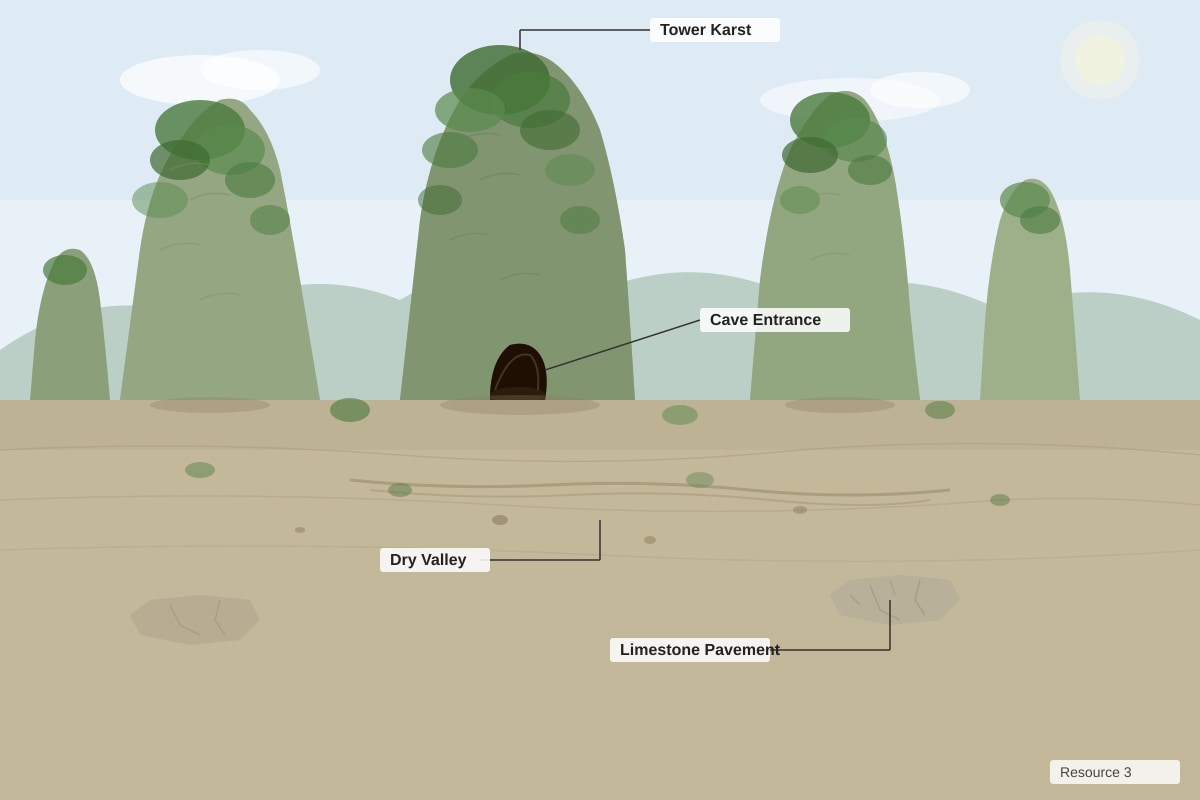
(a) Identify the dominant type of weathering responsible for the formation of this landscape. [1]
Answer: Chemical weathering (specifically carbonation/solution).
Teaching Notes:
- Karst landscapes are formed by the dissolution of soluble rocks, primarily limestone (calcium carbonate).
- Marking: Award 1 mark for "chemical weathering" or "carbonation."
(b) Explain the chemical process of carbonation and its role in the formation of karst landscapes. [4]
Answer: Carbonation is a type of chemical weathering where carbon dioxide (CO₂) from the atmosphere and soil dissolves in rainwater to form a weak carbonic acid (H₂CO₃).
The process:
- CO₂ + H₂O → H₂CO₃ (carbonic acid)
- H₂CO₃ + CaCO₃ (limestone) → Ca(HCO₃)₂ (calcium bicarbonate)
The calcium bicarbonate is soluble and is removed in solution. Over long periods, this dissolution of limestone enlarges joints and bedding planes, creating features such as:
- Surface features: Limestone pavements, sinkholes (dolines), tower karst.
- Subsurface features: Caves, caverns, underground rivers, stalactites and stalagmites.
The process is particularly effective in the humid tropics due to:
- High temperatures, which accelerate chemical reactions.
- Abundant rainfall, providing a continuous supply of acidic water.
- Dense vegetation, which produces high levels of CO₂ in the soil.
Teaching Notes:
- The key equation is: CO₂ + H₂O + CaCO₃ → Ca(HCO₃)₂.
- The product (calcium bicarbonate) is soluble and is removed in solution.
- This is why karst landscapes are associated with limestone and dolomite.
- Marking: Award 1 mark for the correct equation/process, 1 mark for explaining the role of CO₂ and water, 1 mark for linking to karst features, and 1 mark for explaining why it is effective in the tropics.
Question 7 (5 marks)
(a) Distinguish between physical weathering and chemical weathering. [2]
Answer:
- Physical (mechanical) weathering is the breakdown of rocks into smaller fragments without any change in their chemical composition. It involves processes like freeze-thaw, pressure release, and salt weathering.
- Chemical weathering involves the chemical alteration or decomposition of rock minerals, changing their chemical composition. It includes processes like carbonation, hydrolysis, and oxidation.
Teaching Notes:
- The key distinction is whether the rock's chemical composition changes.
- Physical weathering = breaking rocks into smaller pieces of the same material.
- Chemical weathering = changing the rock into a different substance.
- Marking: Award 1 mark for each correct definition.
(b) Explain how pressure release (sheeting) contributes to the weathering of exposed granite rock in a tropical environment. [3]
Answer: Pressure release (also called sheeting or exfoliation) is a type of physical weathering.
- Formation: Granite is an igneous rock formed deep underground under immense pressure from overlying rocks.
- Uplift and exposure: When the overlying rocks are removed by erosion, the granite is exposed at the surface. The pressure on the granite is released.
- Expansion: The granite expands slightly in response to the reduced pressure.
- Fracturing: This expansion causes the outer layers of the granite to crack and peel away in curved sheets, parallel to the surface, a process called exfoliation.
In a tropical environment, this process is enhanced by:
- Thermal weathering: The intense daily heating and cooling of the rock surface can cause expansion and contraction, widening the cracks.
- Chemical weathering: Water can enter the cracks, and chemical weathering (e.g., hydrolysis of feldspar) can further weaken the rock, accelerating the peeling process.
Teaching Notes:
- The key is the release of confining pressure.
- Think of it like a compressed spring being released.
- The result is the formation of exfoliation domes (e.g., Half Dome in Yosemite) or sheet joints.
- Marking: Award 1 mark for explaining the formation under pressure, 1 mark for explaining the release and expansion, and 1 mark for linking to the tropical environment.
Question 8 (5 marks)
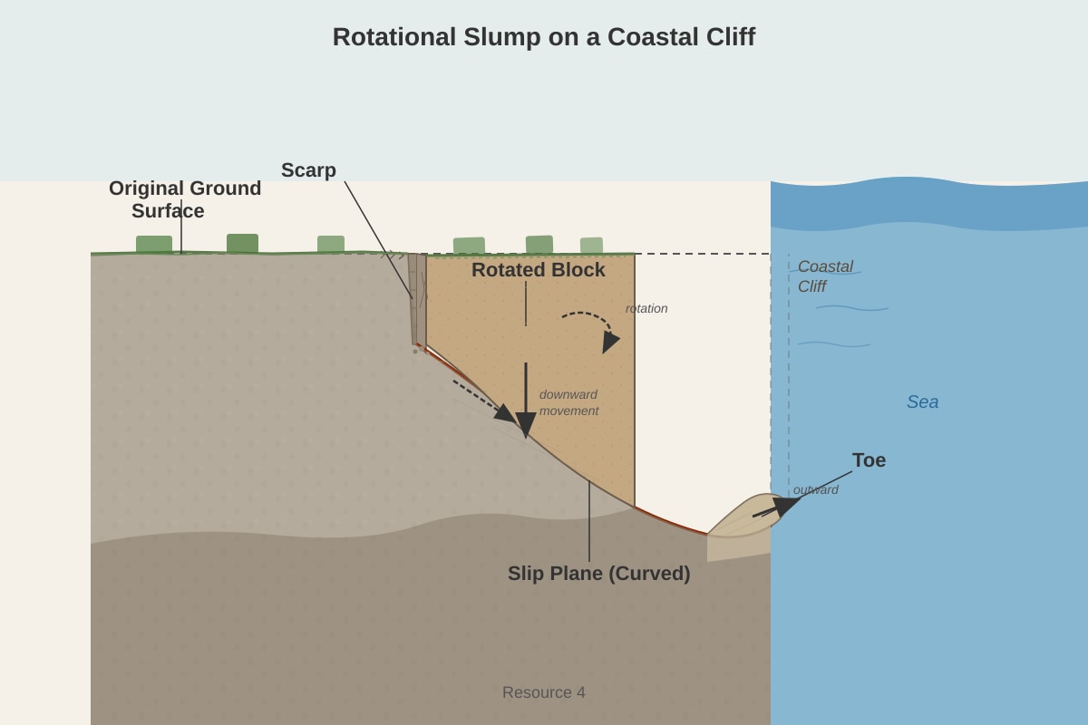
(a) Identify the type of mass movement shown in Resource 4. [1]
Answer: Rotational slump (or rotational slide).
Teaching Notes:
- A rotational slump is a type of landslide where the failure surface is curved (concave-upward).
- The block of material rotates backward as it moves downslope.
- Marking: Award 1 mark for "rotational slump" or "rotational slide."
(b) Explain the natural and human factors that could trigger this type of mass movement in a tropical coastal environment. [4]
Answer:
Natural factors:
- Heavy rainfall: Intense tropical rainfall saturates the soil and rock, increasing pore water pressure. This reduces the effective stress and shear strength of the material, making it more likely to fail along a curved slip plane.
- Wave action at the cliff base: Waves undercut the cliff, removing support from the toe of the slope. This increases the stress on the slope and can trigger a rotational slump.
- Steep slope angle: Coastal cliffs are naturally steep, making them more susceptible to mass movement.
- Geology: The presence of clay layers or weathered rock can create a weak plane along which failure can occur.
Human factors:
- Loading at the cliff top: Construction of buildings or roads on the cliff top adds weight, increasing the stress on the slope.
- Removal of vegetation: Deforestation on the cliff slope reduces root binding, which helps to hold the soil together.
- Alteration of drainage: Inadequate drainage from buildings or roads can channel water into the slope, increasing pore water pressure.
- Excavation at the cliff base: Cutting into the cliff base for road construction or development removes support.
Teaching Notes:
- The key trigger is an increase in shear stress or a decrease in shear strength.
- Water is a critical factor: it adds weight, reduces friction, and increases pore pressure.
- Marking: Award 1 mark for each factor clearly explained (2 natural + 2 human = 4 marks). Accept other valid factors.
Question 9 (5 marks)
(a) Define the term 'splash erosion'. [1]
Answer: Splash erosion is the detachment and movement of soil particles caused by the direct impact of raindrops on the soil surface.
Teaching Notes:
- Raindrops hit the soil with considerable force, dislodging soil particles.
- These particles can be splashed into the air and moved short distances.
- Splash erosion is the first stage of water erosion.
- Marking: Award 1 mark for a correct definition.
(b) Explain how the removal of tropical rainforest vegetation can lead to an increase in rillwash and rainwash. [4]
Answer: Tropical rainforest vegetation plays a crucial role in protecting the soil from erosion. Its removal leads to a cascade of effects:
-
Loss of interception: The dense canopy intercepts rainfall, reducing the kinetic energy of raindrops. Without the canopy, raindrops hit the bare soil directly, causing significant splash erosion.
-
Loss of root binding: Tree roots bind the soil together, increasing its resistance to erosion. Without roots, the soil is more easily detached and transported.
-
Reduced infiltration: The leaf litter and organic matter on the forest floor promote infiltration. Without this layer, the soil surface can become compacted, reducing infiltration and increasing overland flow.
-
Increased overland flow: With reduced interception and infiltration, more water flows over the surface as overland flow. This flowing water picks up the dislodged soil particles.
-
Formation of rills: As overland flow concentrates, it begins to erode small, shallow channels called rills (rillwash). These rills can coalesce into larger gullies.
-
Rainwash: This is the sheet-like flow of water down a slope, carrying dislodged soil particles. With increased overland flow, rainwash becomes more effective at transporting soil.
Teaching Notes:
- The key is the loss of the protective functions of the forest.
- Rillwash is erosion by concentrated flow in small channels (rills).
- Rainwash is erosion by sheet flow.
- Marking: Award 1 mark for explaining the loss of interception, 1 mark for explaining the loss of root binding, 1 mark for explaining increased overland flow, and 1 mark for linking to rillwash and rainwash.
Question 10 (8 marks)
'Fluvial processes are the most significant agent of erosion in tropical landscapes.' Discuss this statement. [8]
Answer:
Introduction (1 mark): Fluvial processes (the action of rivers) are undoubtedly a major agent of erosion in tropical landscapes, but their significance varies spatially and temporally. Other processes, such as chemical weathering and mass movement, also play crucial roles.
Arguments for fluvial processes being most significant (3-4 marks):
-
High rainfall and discharge: The humid tropics receive abundant rainfall, leading to high river discharge. This provides the energy for fluvial erosion processes:
- Corrasion (abrasion): The wearing away of the river bed and banks by the load carried by the river.
- Corrosion (solution): The dissolution of soluble rocks (e.g., limestone) by river water.
- Hydraulic action: The force of the water itself, which can dislodge and remove material.
- Attrition: The wearing down of the river's load as particles collide with each other.
-
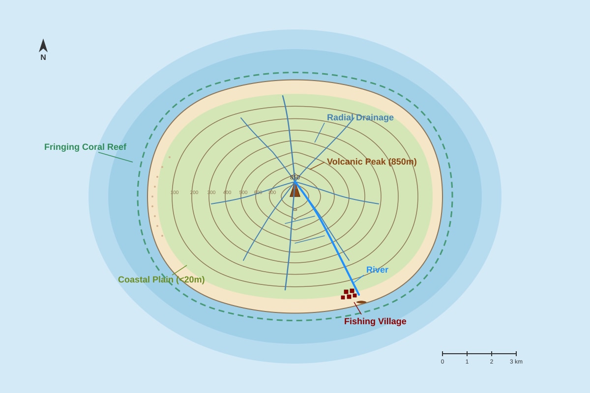
Landscape dissection: Fluvial processes are responsible for dissecting landscapes, creating valleys, gorges, and drainage networks. The radial drainage pattern on volcanic islands (Q16) is a clear example.
-
Transport of material: Rivers are the primary means of transporting weathered material from upland areas to the coast, shaping the entire landscape.
Arguments for other processes being equally or more significant (3-4 marks):
-
Chemical weathering: The high temperatures and abundant rainfall of the tropics make chemical weathering exceptionally rapid. This weakens rocks, making them more susceptible to erosion by other agents. In karst landscapes, chemical weathering (carbonation) is the dominant process.
-
Mass movement: On steep slopes, mass movement processes (slides, slumps, flows) can be very rapid and move large volumes of material. These processes are often triggered by the same heavy rainfall events that drive fluvial erosion.
-
Spatial variation:
- In uplands and headwaters, fluvial erosion (vertical downcutting) and mass movement are dominant.
- In lowlands and floodplains, fluvial deposition is more important than erosion.
- In coastal areas, wave action and coastal processes are the primary agents of erosion.
- In arid tropics, wind erosion can be significant.
-
Human influence: Human activities (deforestation, agriculture, urbanization) can accelerate erosion rates, often overwhelming natural fluvial processes.
Conclusion (1 mark): Fluvial processes are a highly significant, and in many areas the dominant, agent of erosion in the humid tropics. However, they do not act in isolation. They are closely linked with chemical weathering (which provides the material for transport) and mass movement (which delivers material to river channels). The relative significance of each process varies depending on the local geology, climate, topography, and human activity. Therefore, while fluvial processes are arguably the most widespread and continuous agent, they are part of an integrated system of geomorphic processes.
Teaching Notes:
- This is a "discuss" question, requiring a balanced evaluation.
- Use specific examples of fluvial processes and other processes.
- Acknowledge the spatial and temporal variations in the significance of different processes.
- Marking Scheme (8 marks):
- AO1 (Knowledge): 2 marks for demonstrating knowledge of fluvial and other geomorphic processes.
- AO2 (Analysis): 3 marks for analyzing the relative significance of different processes.
- AO3 (Evaluation): 3 marks for making a balanced judgment and reaching a well-supported conclusion.
Section C: Geomorphic Processes and Human Interactions (Questions 11-15)
Question 11 (6 marks)
(a) Describe the pattern of soil loss shown in Resource 5. [2]
Answer: There is a clear positive correlation between the intensity of land use and soil loss. Primary rainforest has the lowest soil loss (0.1 t/ha/yr), while cassava cultivation on sloping land has the highest (45.0 t/ha/yr). Cleared land and oil palm plantations also show significantly higher soil loss than forested areas.
Teaching Notes:
- A description should identify the overall trend and highlight specific data points.
- Use comparative language (e.g., "much higher than," "the lowest").
- Marking: Award 1 mark for identifying the general trend (more intensive land use = more soil loss) and 1 mark for citing specific data.
(b) Explain the relationship between land-use change and the rate of soil erosion in the humid tropics. [4]
Answer: Land-use change from natural forest to agriculture dramatically increases soil erosion rates for several reasons:
-
Removal of protective vegetation cover: The forest canopy intercepts rainfall, reducing its erosive power. When the forest is cleared, raindrops hit the bare soil directly, causing splash erosion.
-
Loss of root systems: Tree roots bind the soil, increasing its resistance to erosion. When roots decay, the soil becomes more easily detached.
-
Reduced organic matter: Forest soils have high organic matter content, which improves soil structure and infiltration. Agricultural practices often reduce organic matter, making the soil more erodible.
-
Soil disturbance: Ploughing and planting disturb the soil, breaking up aggregates and making it more susceptible to erosion.
-
Type of crop: The data shows that cassava (a row crop with slow canopy closure) on sloping land has the highest erosion rate (45 t/ha/yr). In contrast, oil palm plantations, once mature, provide some canopy cover, resulting in lower erosion (8 t/ha/yr) than bare cleared land (15 t/ha/yr).
Teaching Notes:
- The relationship is causal: land-use change causes increased erosion.
- The mechanism involves the loss of the protective functions of the natural vegetation.
- Marking: Award 1 mark for each well-explained point (up to
<stage5_quiz_answers_md>
A-Level Geography H2 Quiz - Physical Geography - ANSWER KEY
Total Marks: 50
Section A: Tropical Climates and Drainage Basins (Questions 1-5)
1. (a) State two key distinguishing characteristics of tropical climates. [2]
Answer:
- High temperatures throughout the year (mean monthly temperature > 18°C).
- High annual rainfall (typically > 1500mm) with a distinct wet season.
(b) Explain how the seasonal migration of the Hadley cell influences rainfall patterns in the humid tropics. [3]
Answer: The Hadley cell migrates north and south with the seasonal movement of the sun. During the summer solstice in each hemisphere, the Intertropical Convergence Zone (ITCZ) shifts towards that hemisphere. This brings intense convection, rising air, and heavy rainfall to areas under the ITCZ. As the ITCZ moves away, the region experiences a drier period under the influence of the subtropical high-pressure belt or trade winds. This seasonal migration creates distinct wet and dry seasons in many tropical regions.
2. (a) Identify the atmospheric and surface conditions required for the development of a tropical cyclone. [3]
Answer:
- Sea surface temperatures of at least 26.5°C to a depth of 50-60m.
- High humidity in the lower and middle troposphere.
- A pre-existing weather disturbance (e.g., a tropical wave).
- Low vertical wind shear (less than 10 m/s between the surface and upper troposphere).
- Location at least 5° from the equator (for Coriolis force to initiate rotation).
(b) Explain how the El Niño Southern Oscillation (ENSO) can influence the frequency and intensity of tropical cyclones in the Pacific Ocean. [4]
Answer: During an El Niño event, warmer sea surface temperatures shift eastward in the Pacific. This leads to:
- Increased cyclone activity in the central and eastern Pacific (e.g., near Hawaii and the coast of Mexico) due to warmer waters and reduced wind shear.
- Decreased cyclone activity in the western Pacific (e.g., near Australia, Philippines, Japan) due to cooler sea surface temperatures and increased wind shear. The opposite occurs during La Niña events, with increased activity in the western Pacific and decreased activity in the central/eastern Pacific.
3. (a) Describe the shape of the hydrograph shown in Resource 2. [2]
Answer: The hydrograph has a steep rising limb, a sharp, high peak discharge (250 cumecs), and a moderately steep falling limb. The lag time is short (4 hours). The baseflow is low (20 cumecs).
(b) Explain how two natural factors could have contributed to the short lag time and high peak discharge shown. [4]
Answer:
- High rainfall intensity: The heavy, intense rainfall (80mm in 6 hours, with highest intensity in first 2 hours) quickly saturates the soil and exceeds infiltration capacity, leading to rapid overland flow (Hortonian overland flow) and a short lag time.
- Steep slopes: If the drainage basin has steep slopes, water flows downhill more quickly, reducing the time for water to reach the river channel and contributing to a steep rising limb and high peak discharge.
- Impermeable geology/saturated soil: If the underlying rock is impermeable (e.g., clay, granite) or the soil is already saturated from previous rainfall, infiltration is limited, and most rainfall becomes overland flow, reaching the river rapidly.
4. (a) Define the term 'drainage basin'. [1]
Answer: A drainage basin is the area of land drained by a river and its tributaries, separated from adjacent basins by a watershed.
(b) With reference to the drainage basin hydrological cycle, distinguish between throughflow and baseflow. [2]
Answer: Throughflow is the lateral movement of water through the soil layer (within the soil profile) downslope towards a river channel. Baseflow is the slow movement of water through the underlying rock (groundwater) that feeds into the river channel, maintaining flow during dry periods.
5. Evaluate the extent to which humans can control fluvial flooding in the humid tropics. [8]
Answer: Humans can control fluvial flooding to a limited extent through a combination of structural and non-structural measures, but complete control is rarely possible due to the high intensity of tropical rainfall and the scale of natural processes.
Structural measures:
- Dams and reservoirs: Can store floodwater and release it slowly, reducing peak discharge. However, they are expensive, can silt up quickly in tropical environments, and may fail during extreme events.
- Levees and embankments: Can contain floodwaters within the channel, but can increase flood risk downstream and may be overtopped by extreme floods.
- Channelization: Straightening and deepening channels can increase flow velocity and reduce local flooding, but can transfer the problem downstream and damage ecosystems.
Non-structural measures:
- Land-use planning: Restricting development on floodplains and preserving wetlands can reduce flood risk.
- Flood forecasting and warning systems: Allow for evacuation and preparation, reducing loss of life and property damage.
- Afforestation and soil conservation: Replanting forests and using sustainable agricultural practices can increase infiltration and reduce surface runoff, but their effect on large floods is limited.
Limitations:
- The sheer intensity of tropical rainfall can overwhelm even the largest engineering structures.
- Rapid population growth and urbanization in tropical floodplains increase vulnerability.
- Deforestation and land-use change exacerbate flooding.
- Climate change is increasing the frequency and intensity of extreme rainfall events.
Conclusion: While humans can reduce the frequency and severity of smaller floods through a combination of measures, complete control of fluvial flooding in the humid tropics is not possible. A focus on adaptation and resilience, rather than complete control, is more realistic.
Section B: Landforms in the Tropics (Questions 6-10)
6. (a) Identify the dominant type of weathering responsible for the formation of this landscape. [1]
Answer: Chemical weathering (specifically carbonation/solution).
(b) Explain the chemical process of carbonation and its role in the formation of karst landscapes. [4]
Answer: Carbonation is a chemical weathering process where carbon dioxide (CO2) from the atmosphere and soil dissolves in rainwater to form weak carbonic acid (H2CO3). This acid reacts with calcium carbonate (CaCO3) in limestone to form soluble calcium bicarbonate (Ca(HCO3)2), which is then removed in solution. Over time, this process dissolves the limestone, creating features such as joints, fissures, caves, and eventually tower karst landscapes.
7. (a) Distinguish between physical weathering and chemical weathering. [2]
Answer: Physical weathering involves the mechanical breakdown of rocks into smaller fragments without changing their chemical composition (e.g., freeze-thaw, exfoliation). Chemical weathering involves the alteration of the chemical composition of minerals, often leading to the formation of new minerals or the removal of material in solution (e.g., carbonation, hydrolysis).
(b) Explain how pressure release (sheeting) contributes to the weathering of exposed granite rock in a tropical environment. [3]
Answer: Granite is formed under high pressure deep within the Earth's crust. When overlying rocks are removed by erosion, the pressure on the granite is reduced. This causes the granite to expand and crack parallel to the surface, forming sheet-like joints (exfoliation). In tropical environments, this process is enhanced by high temperatures and alternating wet and dry conditions, which can cause further expansion and contraction, eventually leading to the peeling off of curved sheets of rock.
8. (a) Identify the type of mass movement shown in Resource 4. [1]
Answer: Rotational slump (or rotational slide).
(b) Explain the natural and human factors that could trigger this type of mass movement in a tropical coastal environment. [4]
Answer: Natural factors:
- Heavy rainfall: Saturates the soil and rock, increasing pore water pressure and reducing shear strength.
- Wave erosion: Undercuts the base of the cliff, removing support and increasing the slope angle.
- Earthquakes: Can trigger landslides in unstable coastal areas.
Human factors:
- Construction on cliff tops: Adds weight to the slope, increasing stress.
- Removal of vegetation: Roots help bind soil and rock; removal reduces slope stability.
- Drainage modifications: Leaking pipes or poor drainage can increase water content in the slope.
9. (a) Define the term 'splash erosion'. [1]
Answer: Splash erosion is the detachment and movement of soil particles caused by the impact of raindrops on the soil surface.
(b) Explain how the removal of tropical rainforest vegetation can lead to an increase in rillwash and rainwash. [4]
Answer: Removal of rainforest vegetation:
- Removes the canopy: Raindrops directly hit the soil surface with high kinetic energy, causing splash erosion and breaking up soil aggregates.
- Reduces interception and infiltration: Less water is intercepted by leaves and stems, and the lack of roots reduces soil porosity, leading to increased surface runoff.
- Removes root binding: Roots that held soil particles together are gone, making the soil more erodible.
- Increases overland flow: The increased surface runoff concentrates into small channels (rills), leading to rillwash, and also flows as a thin sheet (rainwash), removing the topsoil.
10. 'Fluvial processes are the most significant agent of erosion in tropical landscapes.' Discuss this statement. [8]
Answer: Fluvial processes (the action of rivers) are indeed a very significant agent of erosion in tropical landscapes, but they are not the only one, and their significance varies depending on the specific environment.
Arguments for fluvial processes being most significant:
- High rainfall intensity: The heavy, intense rainfall in the humid tropics generates high-energy overland flow and powerful rivers capable of significant erosion and sediment transport.
- Large river systems: Many of the world's largest rivers (e.g., Amazon, Congo, Ganges-Brahmaputra) are in the tropics, carrying vast amounts of sediment and carving deep valleys and gorges.
- Chemical weathering: The warm, wet climate promotes intense chemical weathering, which weakens rocks and makes them more susceptible to fluvial erosion.
Arguments against fluvial processes being the only significant agent:
- Chemical weathering: In many tropical landscapes, chemical weathering (especially hydrolysis and carbonation) is the dominant process, breaking down rocks in situ and creating deep weathering profiles (regolith). This is particularly true in areas of low relief.
- Mass movement: On steep slopes, mass movement processes (e.g., landslides, slumps, soil creep) can be very significant, especially during heavy rainfall events. These processes can move large volumes of material downslope, often more rapidly than fluvial erosion.
- Coastal processes: In coastal areas, wave action, tidal currents, and longshore drift are the dominant erosional agents, shaping cliffs, beaches, and deltas.
- Karst landscapes: In limestone areas, solution (carbonation) is the dominant process, creating unique landforms like caves, sinkholes, and tower karst, with fluvial processes playing a secondary role.
Conclusion: Fluvial processes are undoubtedly a major agent of erosion in tropical landscapes, particularly in areas of high relief and active river systems. However, chemical weathering and mass movement are also extremely significant, and in some environments (e.g., karst, low-relief areas, coasts), they may be more dominant. Therefore, the statement is an overgeneralization; the relative importance of different erosional agents varies spatially within the tropics.
Section C: Geomorphic Processes and Human Interactions (Questions 11-15)
11. (a) Describe the pattern of soil loss shown in Resource 5. [2]
Answer: Soil loss is lowest in primary rainforest (0.1 t/ha/yr) and increases with increasing human disturbance. Selectively logged forest has moderate loss (2.5 t/ha/yr), while cleared land (15.0 t/ha/yr) and oil palm plantation (8.0 t/ha/yr) have much higher losses. The highest loss is from cassava cultivation on sloping land (45.0 t/ha/yr).
(b) Explain the relationship between land-use change and the rate of soil erosion in the humid tropics. [4]
Answer: The relationship is direct: as natural vegetation (especially rainforest) is removed or replaced with less protective land uses, soil erosion rates increase dramatically.
- Rainforest: Provides complete canopy cover, a thick litter layer, and a dense root network that intercepts rainfall, promotes infiltration, and binds soil. Soil loss is minimal.
- Selective logging: Removes some trees, but the canopy and root system are partially intact, so erosion increases but remains moderate.
- Cleared land (slash-and-burn): Complete removal of vegetation exposes bare soil to raindrop impact and overland flow, leading to high erosion rates.
- Oil palm plantation: Provides some canopy cover, but the understory is often cleared, and the soil is disturbed during planting, leading to moderate to high erosion.
- Cassava cultivation on slopes: Involves frequent tillage, leaving soil bare for long periods, and is often practiced on steep slopes, leading to extremely high erosion rates.
12. (a) Name two types of chemical weathering that are particularly active in tropical environments. [2]
Answer:
- Hydrolysis
- Oxidation (Also acceptable: Carbonation, Solution)
(b) For one of the types named in (a), explain the process and its effect on the rock. [3]
Answer (for Hydrolysis): Hydrolysis is the chemical reaction between minerals in the rock and water. In tropical environments, the abundant warm water reacts with silicate minerals (e.g., feldspar) in granite to form clay minerals (e.g., kaolinite) and release soluble ions (e.g., potassium, sodium). This process weakens the rock, turning hard granite into soft, crumbly clay-rich regolith.
Answer (for Oxidation): Oxidation is the reaction of minerals (especially those containing iron) with oxygen, often dissolved in water. In tropical environments, iron-rich minerals (e.g., biotite, pyrite) are oxidized to form iron oxides (e.g., hematite, limonite), which give the soil a characteristic red or yellow color. This process weakens the rock and can cause it to disintegrate.
13. Explain how freeze-thaw weathering can occur in a tropical highland environment. [3]
Answer: Freeze-thaw weathering requires temperatures to fluctuate above and below 0°C. In tropical highlands (e.g., the Andes, Mount Kilimanjaro), nighttime temperatures can drop below freezing, while daytime temperatures rise above freezing due to intense solar radiation. Water enters cracks in rocks during the day, freezes at night, expands by 9%, and exerts pressure on the rock. Repeated cycles of freezing and thawing cause the cracks to widen and eventually break the rock apart.
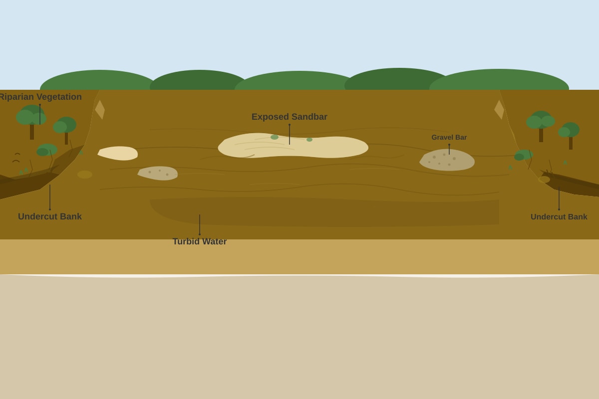
14. (a) Describe the characteristics of the river channel shown in Resource 6. [2]
Answer: The channel is wide and shallow with exposed sandbars and gravel bars. The water is brown and turbid. The banks are steep and unstable with evidence of undercutting. Riparian vegetation is present but sparse.
(b) Explain how the river channel characteristics shown in Resource 6 are related to the seasonal climate of the humid tropics. [4]
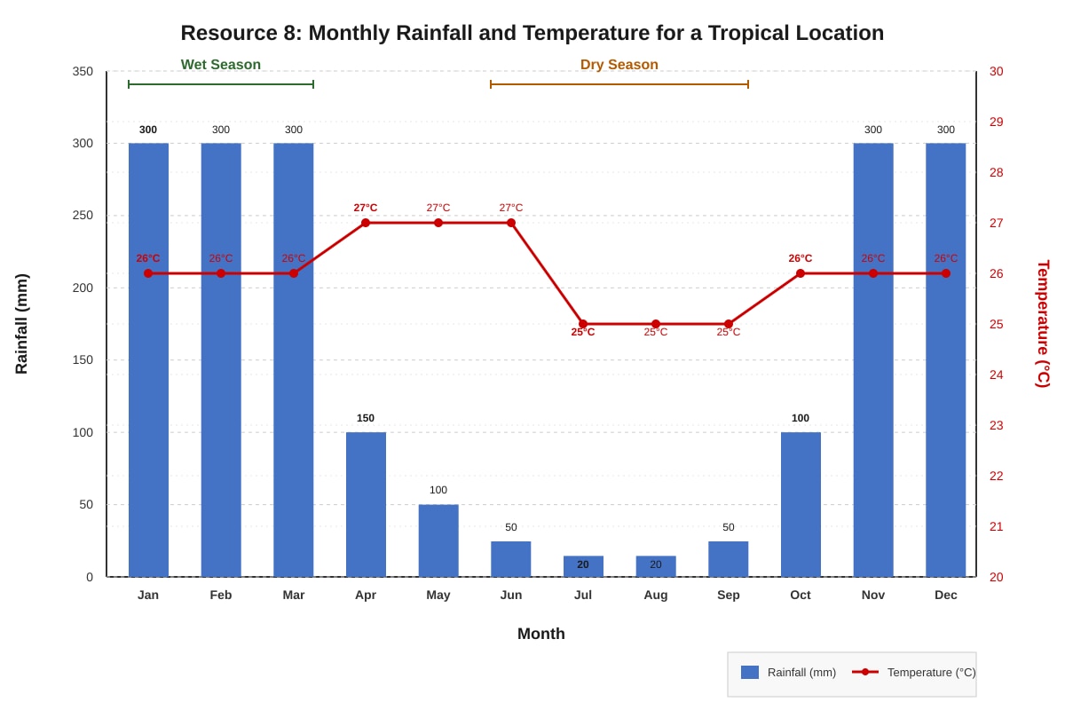
Answer: The humid tropics have distinct wet and dry seasons.
- During the wet season: High river discharge and flow velocity cause erosion of the banks (undercutting) and transport of large amounts of sediment (giving the water a brown, turbid appearance).
- During the dry season: River discharge decreases significantly, exposing sandbars and gravel bars that were deposited during the wet season. The lower flow velocity allows sediment to settle, but the channel remains wide from the wet season erosion. The steep, unstable banks are a result of the alternating erosion (wet season) and lack of support (dry season).
15. (a) Define the term 'sustainable development'. [1]
Answer: Sustainable development is development that meets the needs of the present without compromising the ability of future generations to meet their own needs.
(b) Suggest two sustainable management strategies for reducing soil erosion on tropical hillslopes. [4]
Answer:
- Terracing: Constructing level platforms (terraces) on slopes reduces the gradient, slows runoff, and increases infiltration, thereby reducing soil erosion.
- Agroforestry: Integrating trees with crops provides canopy cover, root binding, and organic matter, which improves soil structure and reduces erosion.
- Contour ploughing: Ploughing along the contour lines of a slope creates ridges that act as barriers to runoff, reducing erosion.
- Cover cropping: Planting cover crops (e.g., legumes) between main crops protects the soil from raindrop impact and reduces runoff.
- Mulching: Applying a layer of organic material (e.g., crop residues) on the soil surface protects it from erosion and improves soil moisture.
End of Answer Key