A-Level Geography H2 Quiz - Physical Geography
Name: ___________________________
Class: ___________________________
Date: ___________________________
Score: _______ / 40
Duration: 60 minutes
Total Marks: 40
Topic: Physical Geography (Tropical Environments – Climate, Drainage Basins, Landforms)
Instructions:
- Answer all 20 questions.
- Section A: Short structured questions (1–10).
- Section B: Data- and source-based questions (11–15).
- Section C: Extended response (16–20).
- Use the resources provided. Write clearly and concisely.
- Marks for each question are shown in brackets [ ].
Section A: Short Structured Questions (1–10)
1. State the Köppen-Geiger climate classification code for a tropical rainforest climate. [1]
2. Name the atmospheric circulation cell that drives tropical rainfall patterns through seasonal migration. [1]
3. Identify one natural input into a tropical drainage basin system. [1]
4. State one type of chemical weathering that is common in the humid tropics. [1]
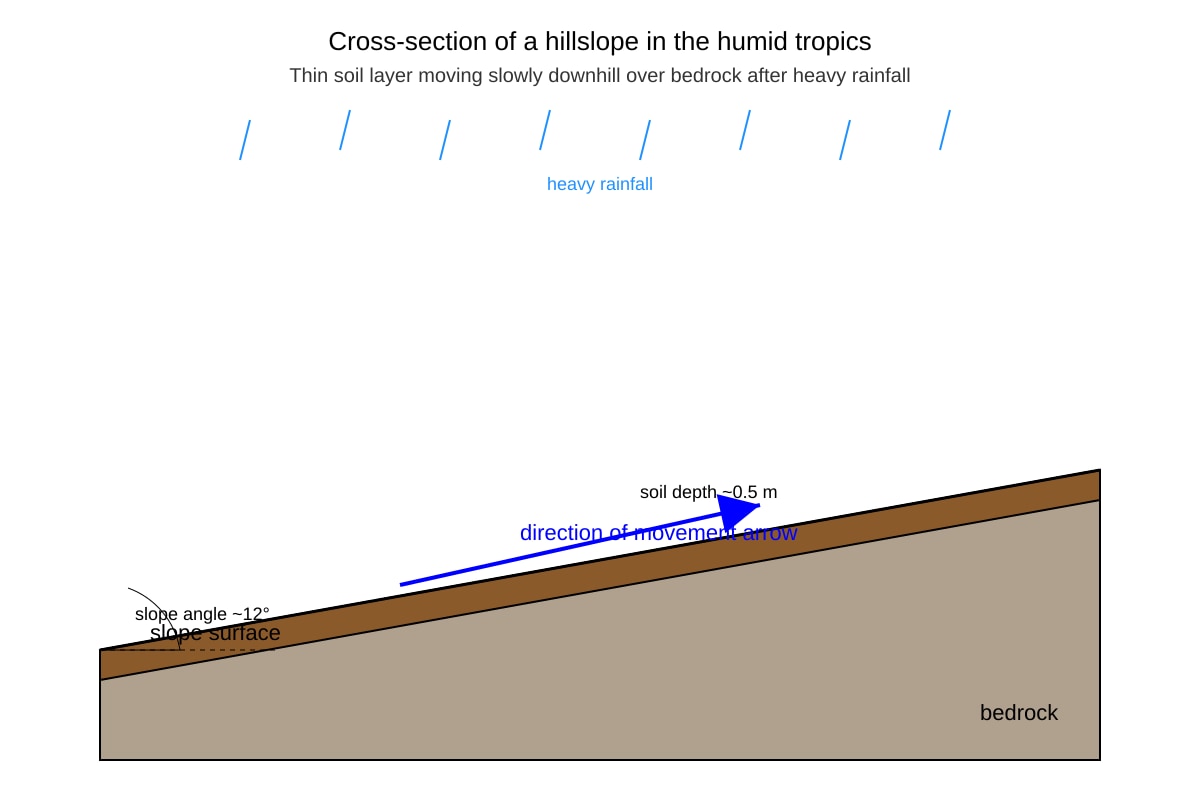
5. Identify the mass movement type shown in Resource 1 where a saturated soil layer moves slowly downhill as a continuous sheet.
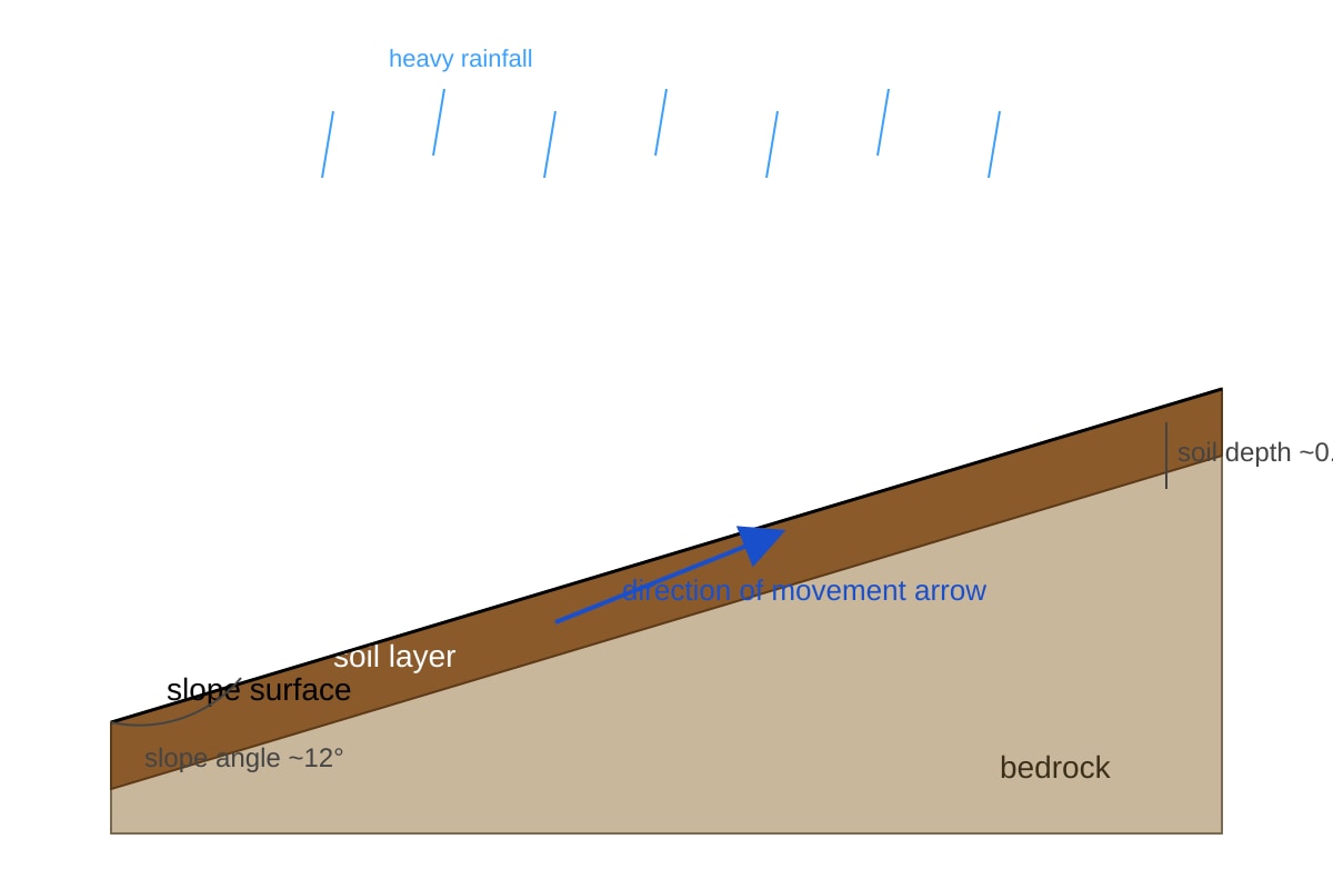
Generated diagram for Q5.
[1]
6. Name the phase of ENSO associated with below-average rainfall over the tropical eastern Pacific. [1]
7. State one storage component of a drainage basin other than channel storage. [1]
8. Identify one fluvial erosion process operating in tropical rivers. [1]
9. State one condition required for tropical cyclone development. [1]
10. Name the geomorphic process where rock breaks down in place due to repeated heating and cooling in arid tropics. [1]
Section B: Data- and Source-Based Questions (11–15)
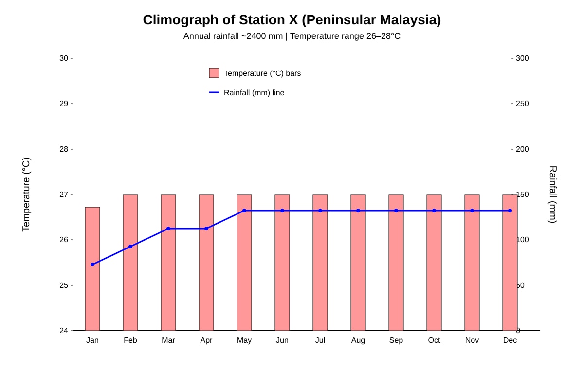
11. Study Resource 2 showing mean monthly temperature and rainfall for Station X in Peninsular Malaysia.
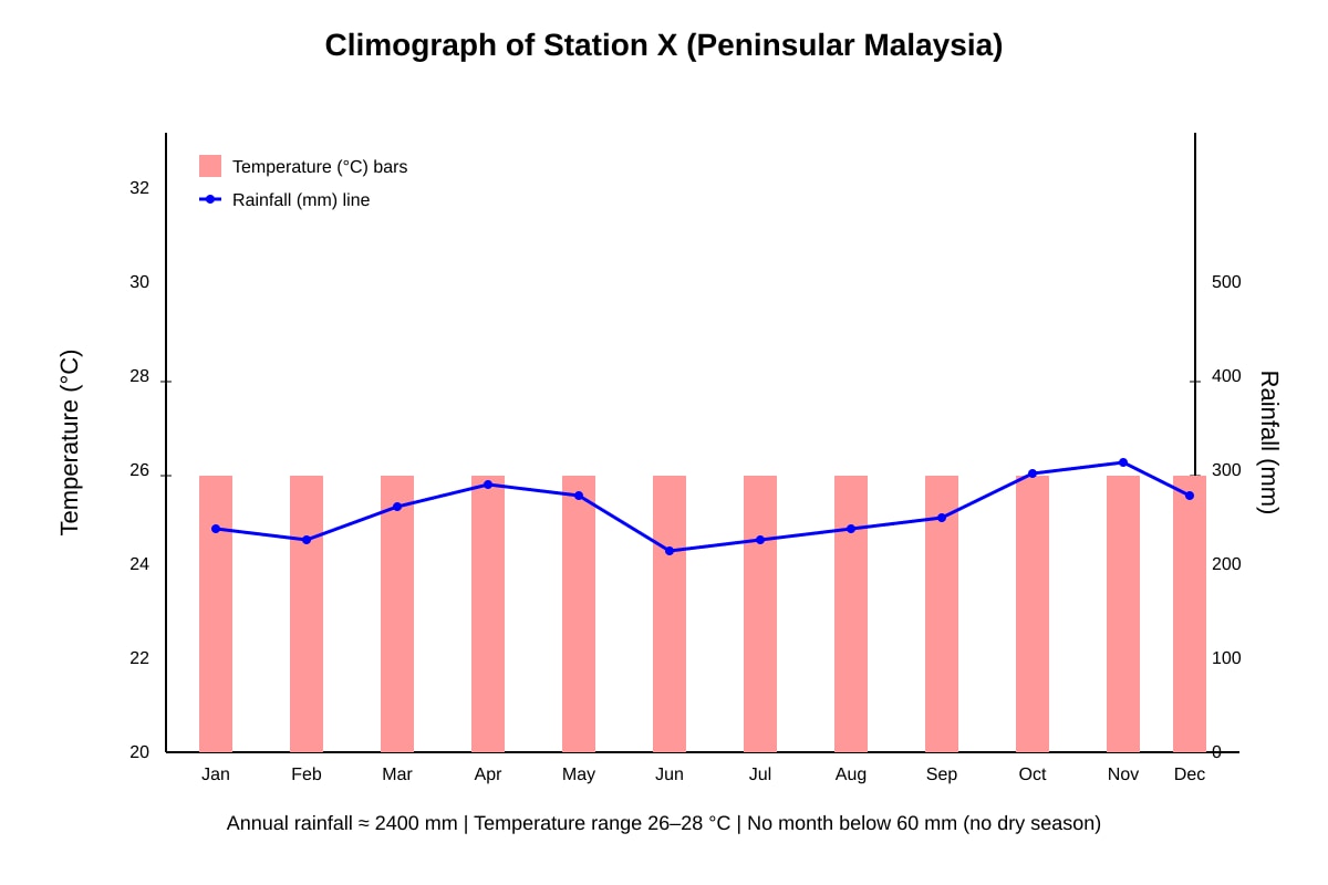
Generated graph for Q11.
(a) Identify the tropical climate zone of Station X using the Köppen-Geiger system. [1]
(b) Give one climatic characteristic from the graph that supports your answer. [1]
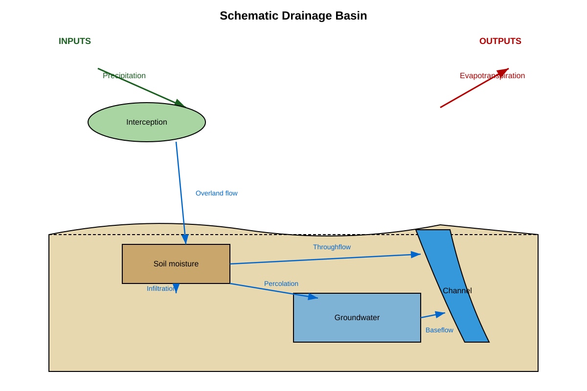
12. Resource 3 shows a tropical drainage basin with labelled stores and flows.
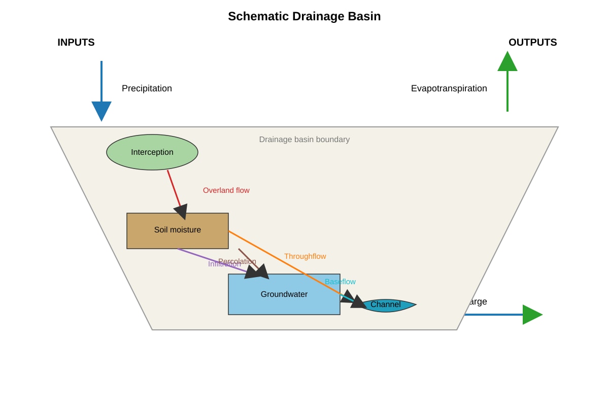
Generated diagram for Q12.
Describe two pathways by which water moves from precipitation to river discharge in this basin. [2]
13. Resource 4 is a table of biomass and vegetation layers for a tropical rainforest in Borneo.
| Layer | Mean height (m) | Biomass (t/ha) |
|---|
| Emergent | 35–45 | 40 |
| Canopy | 20–35 | 180 |
| Understory | 5–20 | 35 |
| Ground | 0–5 | 10 |
Describe the vegetation structure and total mean biomass of the forest. [3]
14. Explain how monsoon circulations produce the wet season in humid tropical Asia. [4]
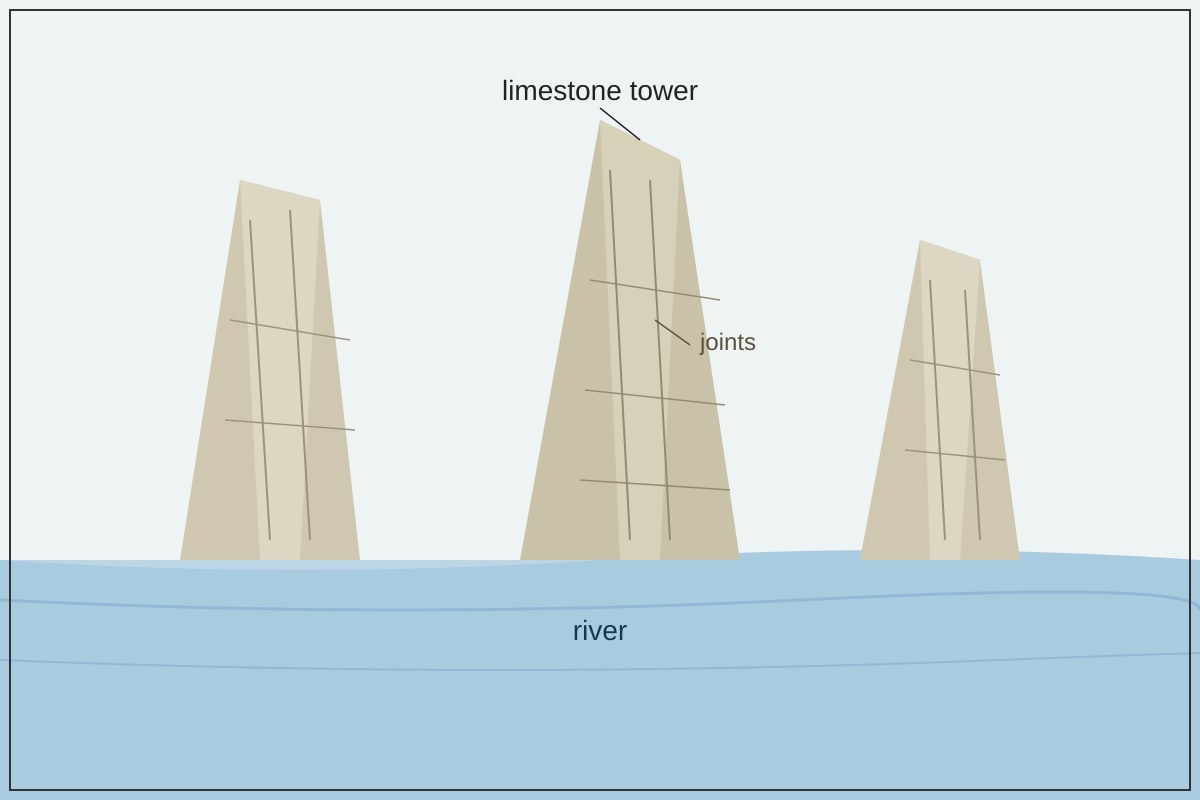
15. Resource 5 shows a limestone tower karst landscape in Guilin, China.
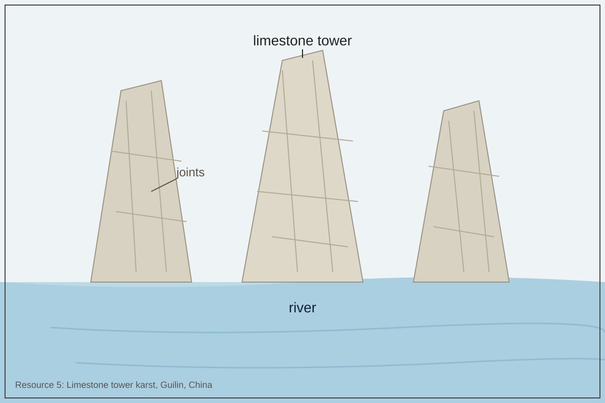
Generated figure for Q15.
Explain two geomorphic processes that have contributed to the formation of this karst landscape. [4]
Section C: Extended Response (16–20)
16. Explain how natural and human factors influence fluvial flooding in the humid tropics. [5]
17. To what extent can humans control fluvial floods in the tropics? Assess the strengths and limitations of management strategies. [6]
18. Compare the characteristics of tropical cyclone development conditions with those of El Niño phases in the tropical Pacific. [4]
19. Explain the role of chemical weathering in shaping landforms in the tropics, using one example. [5]
20. Evaluate the impacts of fluvial flooding on different groups of people in a tropical city, with reference to variations in vulnerability. [6]
</stage3_quiz_answers_md>
A-Level Geography H2 Quiz - Physical Geography (Answer Key)
Topic: Physical Geography
Total Marks: 40
Section A: Short Structured Questions (1–10)
1. [1]
Answer: Af (tropical rainforest).
Teaching note: Köppen-Geiger classifies tropical rainforest as Af — no dry season, high rainfall every month. Common mistake: writing "Am" (monsoon) or "Aw" (savanna).
2. [1]
Answer: Hadley cell.
Teaching note: Hadley cells are tropical atmospheric circulation loops; their seasonal migration shifts rain belts. Mark for naming the cell only.
3. [1]
Answer: Precipitation (or snowmelt — not applicable in most tropics but accepted per syllabus).
Teaching note: Inputs to a drainage basin are precipitation and snowmelt. Most tropical basins rely on precipitation.
4. [1]
Answer: Hydrolysis / carbonation / oxidation / reduction / solution (any one).
Teaching note: Chemical weathering dominates humid tropics due to heat and moisture. Accept any syllabus-listed type.
5. [1]
Answer: Creep (soil creep / mass creep).
Teaching note: Resource shows slow continuous sheet movement of saturated soil — characteristic of creep. Not slide (no distinct scarp) or flow (no liquefied mass).
6. [1]
Answer: El Niño.
Teaching note: El Niño = warm SST anomaly, suppressed convection, below-average rainfall in eastern tropical Pacific.
7. [1]
Answer: Groundwater storage / interception storage / soil moisture storage (any one).
Teaching note: Syllabus lists four stores; channel is excluded by the question.
8. [1]
Answer: Corrasion / corrosion / cavitation (any one fluvial erosion process).
Teaching note: Fluvial erosion = river's wearing of bed/banks. Corrasion = abrasion by load; corrosion = chemical; cavitation = vapour bubbles.
9. [1]
Answer: Sea-surface temperature ≥ 26.5°C / low vertical wind shear / sufficient Coriolis force (any one).
Teaching note: At least one condition for tropical cyclone genesis.
10. [1]
Answer: Thermal weathering (insolation weathering).
Teaching note: Arid tropics have large diurnal temperature ranges causing expansion/contraction.
Section B: Data- and Source-Based Questions (11–15)
11. [2]
(a) [1] Af (tropical rainforest).
(b) [1] Rainfall exceeds 60 mm in every month / temperature stays 26–28°C all year.
Teaching note: Climograph shows no dry season and constantly high temp → Af. Mark each part separately.
12. [2]
Answer (any two pathways, 1 mark each):
- Infiltration → throughflow → river discharge (water enters soil, moves laterally to channel).
- Percolation → groundwater → baseflow → river discharge (deep storage slow release).
- Overland flow → channel flow → river discharge (direct runoff).
Teaching note: Must show movement from input to output via a named pathway.
13. [3]
Answer:
- Structure: Four layers — emergent (35–45 m), canopy (20–35 m, densest), understory (5–20 m), ground (0–5 m). [1]
- Total mean biomass: 40 + 180 + 35 + 10 = 265 t/ha. [1]
- Canopy dominates biomass. [1]
Teaching note: Describe vertical structure with heights, then sum biomass with units.
14. [4]
Answer (mark descriptors: 1 mark per valid point, max 4):
- Summer monsoon: land heats faster than ocean → low pressure over land.
- Moist ocean air flows onshore → uplift → convection rainfall.
- Winter monsoon reverses; offshore dry winds.
- Wet season = summer monsoon onset, high humidity, orographic enhancement.
Teaching note: Link pressure gradient to moisture transport.
15. [4]
Answer (2 processes × 2 marks each):
- Chemical weathering (carbonation/solution): Rain + CO₂ → H₂CO₃; dissolves CaCO₃ along joints. [2]
- Fluvial erosion: River at base removes weathered material, undercuts towers. [2]
Teaching note: Karst needs soluble rock + water; explain mechanism, not just name.
Section C: Extended Response (16–20)
16. [5]
Mark breakdown: natural factors (2) + human factors (2) + link (1).
- Natural: intense convectional rainfall, basin shape, impermeable rock.
- Human: deforestation → less interception, urbanisation → more runoff.
- Synthesis: combined effect increases peak discharge.
Teaching note: Must cover both sides and show interaction.
17. [6]
Mark descriptors:
- Strategies: dams, levees, floodplain zoning (2).
- Strengths: reduce peak flow, protect assets (2).
- Limitations: costly, displace people, climate uncertainty (2).
Conclusion: partial control only.
Teaching note: Evaluate "extent" — not absolute control.
18. [4]
Answer:
- Cyclone: needs warm SST ≥26.5°C, low shear, Coriolis. [2]
- El Niño: warm anomaly eastern Pacific, suppresses convection there, shifts rain west. [2]
Teaching note: Contrast genesis conditions vs. teleconnection phase.
19. [5]
Mark: process (2) + example (2) + link (1).
- Process: hydrolysis of feldspar → clay; solution of limestone.
- Example: karst tower from carbonation.
- Link: produces rounded forms, caves.
Teaching note: Use syllabus chemical types with tropical context.
20. [6]
Mark: impacts (2) + vulnerability variation (2) + groups (2).
- Impacts: loss of property, crop loss, but recharge soils.
- Vulnerability: poor live on floodplains, lack insurance.
- Groups: low-income vs. wealthy; informal vs. formal settlers.
Teaching note: Must show differential impact by social group.
</stage3_quiz_answers_md>
<stage3_quiz_md>
A-Level Geography H2 Quiz - Physical Geography
Name: ___________________________
Class: ___________________________
Date: ___________________________
Score: _______ / 40
Duration: 60 minutes
Total Marks: 40
Topic: Physical Geography (Tropical Environments – Climate, Drainage Basins, Landforms)
Instructions:
- Answer all 20 questions.
- Section A: Short structured questions (1–10).
- Section B: Data- and source-based questions (11–15).
- Section C: Extended response (16–20).
- Use the resources provided. Write clearly and concisely.
- Marks for each question are shown in brackets [ ].
Section A: Short Structured Questions (1–10)
1. State the Köppen-Geiger climate classification code for a tropical rainforest climate. [1]
2. Name the atmospheric circulation cell that drives tropical rainfall patterns through seasonal migration. [1]
3. Identify one natural input into a tropical drainage basin system. [1]
4. State one type of chemical weathering that is common in the humid tropics. [1]
5. Identify the mass movement type shown in Resource 1 where a saturated soil layer moves slowly downhill as a continuous sheet.
Generated diagram for Q5.
[1]
6. Name the phase of ENSO associated with below-average rainfall over the tropical eastern Pacific. [1]
7. State one storage component of a drainage basin other than channel storage. [1]
8. Identify one fluvial erosion process operating in tropical rivers. [1]
9. State one condition required for tropical cyclone development. [1]
10. Name the geomorphic process where rock breaks down in place due to repeated heating and cooling in arid tropics. [1]
Section B: Data- and Source-Based Questions (11–15)
11. Study Resource 2 showing mean monthly temperature and rainfall for Station X in Peninsular Malaysia.
Generated graph for Q11.
(a) Identify the tropical climate zone of Station X using the Köppen-Geiger system. [1]
(b) Give one climatic characteristic from the graph that supports your answer. [1]
12. Resource 3 shows a tropical drainage basin with labelled stores and flows.
Generated diagram for Q12.
Describe two pathways by which water moves from precipitation to river discharge in this basin. [2]
13. Resource 4 is a table of biomass and vegetation layers for a tropical rainforest in Borneo.
| Layer | Mean height (m) | Biomass (t/ha) |
|---|
| Emergent | 35–45 | 40 |
| Canopy | 20–35 | 180 |
| Understory | 5–20 | 35 |
| Ground | 0–5 | 10 |
Describe the vegetation structure and total mean biomass of the forest. [3]
14. Explain how monsoon circulations produce the wet season in humid tropical Asia. [4]
15. Resource 5 shows a limestone tower karst landscape in Guilin, China.
Generated figure for Q15.
Explain two geomorphic processes that have contributed to the formation of this karst landscape. [4]
Section C: Extended Response (16–20)
16. Explain how natural and human factors influence fluvial flooding in the humid tropics. [5]
17. To what extent can humans control fluvial floods in the tropics? Assess the strengths and limitations of management strategies. [6]
18. Compare the characteristics of tropical cyclone development conditions with those of El Niño phases in the tropical Pacific. [4]
19. Explain the role of chemical weathering in shaping landforms in the tropics, using one example. [5]
20. Evaluate the impacts of fluvial flooding on different groups of people in a tropical city, with reference to variations in vulnerability. [6]