From Real Exams Quiz
A Level H2 Geography Physical Geography Quiz
Free A Level H2 Geography Physical Geography quiz, Exam version, with questions, answers, and A Level-style practice for Singapore students.
These static practice materials are generated from the site's syllabus and paper-generation workflow, with source and model context shown so students and parents can evaluate the material before use.
Questions
Free quiz and exam paper access
Enter your details to view this paper
Your access is remembered on this device.
Answers
A-Level Geography H2 Quiz - Physical Geography (Answer Key)
Total Marks: 100 Duration: 1 hour 30 minutes
Section A: Short Answer Questions (20 marks)
1. Define the term drainage basin. [2]
Answer: A drainage basin is an area of land drained by a river and its tributaries. It is separated from adjacent basins by a watershed (or drainage divide). All precipitation that falls within the basin will eventually flow towards the main river channel or be lost through evapotranspiration.
Marking notes:
- 1 mark for identifying it as an area drained by a river system.
- 1 mark for mentioning the watershed/drainage divide.
Common mistakes: Confusing drainage basin with river channel itself, or omitting the concept of the watershed boundary.
2. State two inputs and two outputs in the drainage basin hydrological cycle. [4]
Answer:
| Inputs | Outputs |
|---|---|
| (i) Precipitation (rain, snow, hail) | (i) Evapotranspiration |
| (ii) Snowmelt (only in areas with seasonal snow) | (ii) River discharge (channel flow out of the basin) |
Alternative correct answers:
- Inputs could also include: condensation, or water transferred from adjacent basins via canals.
- Outputs could also include: deep groundwater leakage to other basins, or abstraction by humans.
Marking scheme:
- 1 mark for each correct input (max 2).
- 1 mark for each correct output (max 2).
3. Identify the three main types of tropical climate zones according to the Köppen-Geiger classification based on rainfall amount and seasonality. [3]
Answer: (i) Tropical Rainforest (Af) — no dry season, rainfall ≥ 60 mm every month. (ii) Tropical Monsoon (Am) — short dry season but total rainfall sufficient to support rainforest. (iii) Tropical Savanna (Aw) — distinct dry season in winter, with lower total annual rainfall.
Marking notes:
- 1 mark for each correct climate type (Af, Am, Aw).
- Accept either the letter code (Af/Am/Aw) or the full name (Tropical Rainforest/Monsoon/Savanna).
Common mistakes: Listing tropical desert (BWh) or subtropical steppe (BSh) — these belong to the arid tropics, not the humid tropics classification.
4. Briefly distinguish between throughflow and baseflow as pathways of water movement in a drainage basin. [3]
Answer:
- Throughflow is the lateral movement of water through the soil layer, above the water table, moving slowly downslope through soil pores and pipes. It contributes to streamflow relatively quickly after a rainfall event.
- Baseflow is the movement of groundwater from the saturated zone (aquifer) into the river channel. It is much slower than throughflow and sustains river flow during dry periods.
Marking scheme:
- 1 mark for identifying throughflow as water moving through soil.
- 1 mark for identifying baseflow as groundwater movement.
- 1 mark for a clear distinction (e.g., speed, location relative to water table, contribution to river flow in dry vs wet periods).
Common mistakes: Confusing throughflow with interflow (same process, different terminology); confusing baseflow with overland flow.
5. Name the geomorphic process by which soluble rock, such as limestone, is dissolved by acidic water. [1]
Answer: Carbonation (or solution weathering).
Marking notes:
- Accept either "carbonation" or "solution" or "chemical weathering by carbonation".
- The chemical equation is: CaCO₃ + H₂CO₃ → Ca(HCO₃)₂ (calcium bicarbonate, which is soluble and removed in solution).
6. Explain the role of interception storage in the hydrological cycle. [3]
Answer: Interception storage refers to water that is caught and held on the surfaces of vegetation (leaves, branches, stems) before it reaches the ground. Its role includes:
- Delaying the arrival of precipitation at the ground surface, thereby increasing lag time and reducing peak discharge.
- Water held on leaf surfaces can be directly evaporated back into the atmosphere (interception loss), reducing the net amount of water reaching the ground.
- It protects the soil surface from the kinetic energy of raindrops, reducing splash erosion and surface crusting.
Marking scheme:
- 1 mark for definition.
- 1 mark for explaining delay/increased lag time.
- 1 mark for explaining evaporation loss or soil protection.
7. State two human factors that can increase the risk of fluvial flooding in the humid tropics. [2]
Answer: (i) Urbanisation — replacing permeable surfaces (forest, soil) with impermeable surfaces (concrete, tarmac) reduces infiltration and increases overland flow, increasing peak discharge and shortening lag time. (ii) Deforestation — removal of trees reduces interception storage and evapotranspiration, leading to more water reaching the ground more quickly, increasing flood risk.
Alternative correct answers:
- River channel modification (e.g., straightening, removing meanders).
- Agricultural drainage and land drainage.
- Construction on floodplains (encroachment).
Marking scheme: 1 mark for each valid factor, with a brief explanation.
8. What is the key distinguishing climatic characteristic of the tropics? [1]
Answer: High temperatures (or consistently high mean monthly temperatures, typically > 18°C throughout the year).
Marking notes:
- Accept "high temperatures" or "consistently high insolation" or "small annual temperature range."
- Do not accept "high rainfall" alone, as some tropical areas (deserts) experience low rainfall but are still tropical due to temperature.
9. Define mass movement and identify one type of mass movement that involves very slow movement of soil down a slope. [2]
Answer:
- Mass movement is the downslope movement of soil, rock, or regolith under the influence of gravity.
- Soil creep (or simply creep) is the very slow, gradual downslope movement of soil.
Alternative correct answers for slow type: solifluction (in periglacial zones, though less common in tropics; minor credit if related to slow movement).
Marking scheme:
- 1 mark for definition including gravity as the driving force.
- 1 mark for correct identification of creep.
10. Explain how vegetation cover affects the rate of infiltration in a drainage basin. [3]
Answer: Vegetation cover generally increases infiltration rates. Dense vegetation intercepts rainfall, reducing its kinetic energy and preventing soil surface sealing. The root systems create macropores in the soil, enhancing permeability. Leaf litter on the forest floor absorbs water and slows overland flow, allowing more time for infiltration. In contrast, bare or sparsely vegetated areas experience surface crusting and compaction, reducing infiltration and increasing overland flow.
Marking scheme:
- 1 mark for stating that vegetation generally increases infiltration.
- 1 mark for explaining interception and root effects.
- 1 mark for contrasting with bare ground or explaining the mechanism.
Section B: Data-Response Questions (40 marks)
Question 11
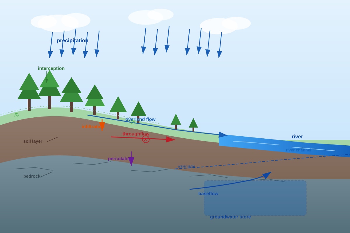
(a) Identify the pathway labelled X that represents the lateral movement of water within the soil layer. [1]
Answer: Throughflow.
Explanation: Throughflow is the lateral movement of water through the unsaturated soil layer. It occurs after infiltration and moves water downslope toward the river channel.
(b) Explain two natural factors that could reduce the amount of overland flow shown in the diagram. [4]
Answer: Natural factors that reduce overland flow (surface runoff) include:
-
High infiltration capacity of soil: If the soil is porous and permeable (e.g., sandy soil), water infiltrates rapidly rather than flowing across the surface. This high infiltration rate reduces the volume of overland flow.
-
Dense vegetation cover: Forested areas intercept rainfall, reducing the kinetic energy of raindrops. The roots create macropores, and leaf litter absorbs water, slowing surface flow and allowing more time for infiltration.
Marking scheme:
- 1 mark for each valid factor (max 2).
- 1 mark for each explanation of how it reduces overland flow (max 2).
Question 12
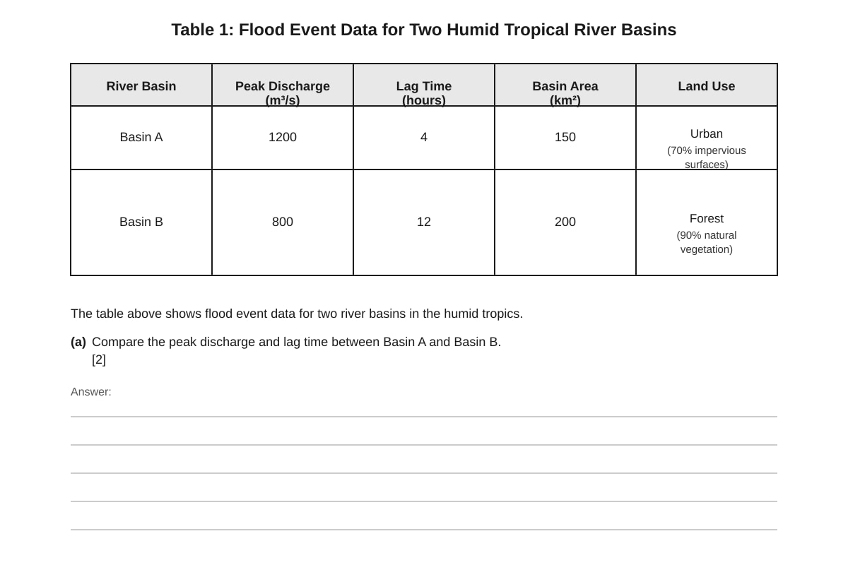
(a) Compare the peak discharge and lag time between Basin A and Basin B. [2]
Answer: Basin A has a higher peak discharge (1200 m³/s) compared to Basin B (800 m³/s). Basin A also has a shorter lag time (4 hours) compared to Basin B (12 hours).
Marking scheme:
- 1 mark for comparing peak discharge.
- 1 mark for comparing lag time.
(b) Explain why the differences in land use between Basin A and Basin B account for the observed differences in flood response. [4]
Answer: Basin A is 70% urban with impervious surfaces (concrete, tarmac). This means:
- Infiltration is greatly reduced, so a higher proportion of rainfall becomes overland flow.
- Overland flow moves quickly over smooth, impermeable surfaces, reaching the river channel rapidly, shortening lag time.
- The lack of vegetation reduces interception and evapotranspiration, further increasing the volume of water reaching the river quickly, leading to a higher peak discharge.
Basin B is 90% forested with natural vegetation. This means:
- High interception storage by tree canopies and leaf litter.
- Root systems create macropores, increasing infiltration and soil water storage.
- Water moves more slowly through the soil as throughflow, increasing lag time.
- Evapotranspiration removes water from the basin, reducing the total runoff volume, leading to a lower peak discharge.
Marking scheme:
- 1 mark for explaining reduced infiltration in urban area.
- 1 mark for explaining faster runoff and shorter lag time in urban area.
- 1 mark for explaining increased interception and infiltration in forested area.
- 1 mark for explaining slower runoff and lower peak discharge in forested area.
Question 13
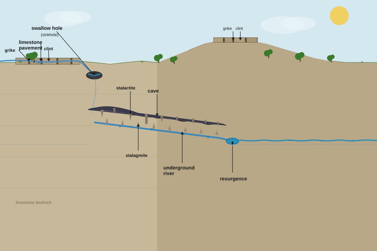
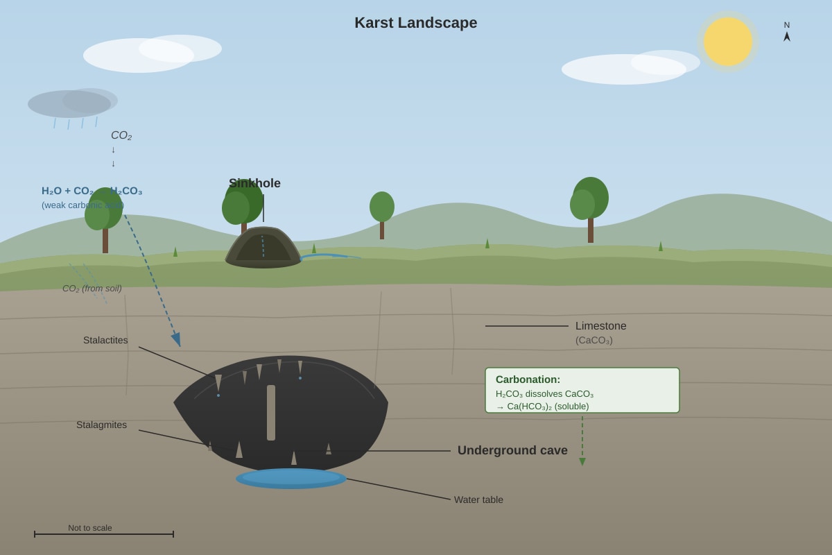
(a) Refer to the figure above showing a karst landscape. Identify the process primarily responsible for the formation of the sinkhole and underground cave. [1]
Generated figure for this question.
Answer: Carbonation (or solution weathering).
Explanation: Rainwater absorbs CO₂ from the atmosphere and soil, forming weak carbonic acid. This acid dissolves calcium carbonate (limestone), creating caves and sinkholes over time.
(b) Explain the role of vegetation and soil in enhancing chemical weathering on a limestone pavement. [4]
Answer: Vegetation and soil enhance chemical weathering in several ways:
-
Root respiration: Plant roots respire, releasing CO₂ into the soil. This increases the concentration of carbonic acid in soil water, enhancing the dissolution of limestone.
-
Organic matter decomposition: Decomposing leaf litter and organic matter produce organic acids (e.g., humic acid) that further acidify soil water, accelerating chemical weathering.
-
Soil moisture retention: Soil retains water, keeping the limestone surface moist for longer periods, allowing chemical reactions to continue over extended times.
-
Concentrated flow: Soil and vegetation direct water into grikes (fissures), concentrating acidic water on specific parts of the limestone, enhancing differential weathering.
Marking scheme:
- 1 mark for each valid role (max 2).
- 1 mark for explaining how each role enhances chemical weathering (max 2).
Question 14
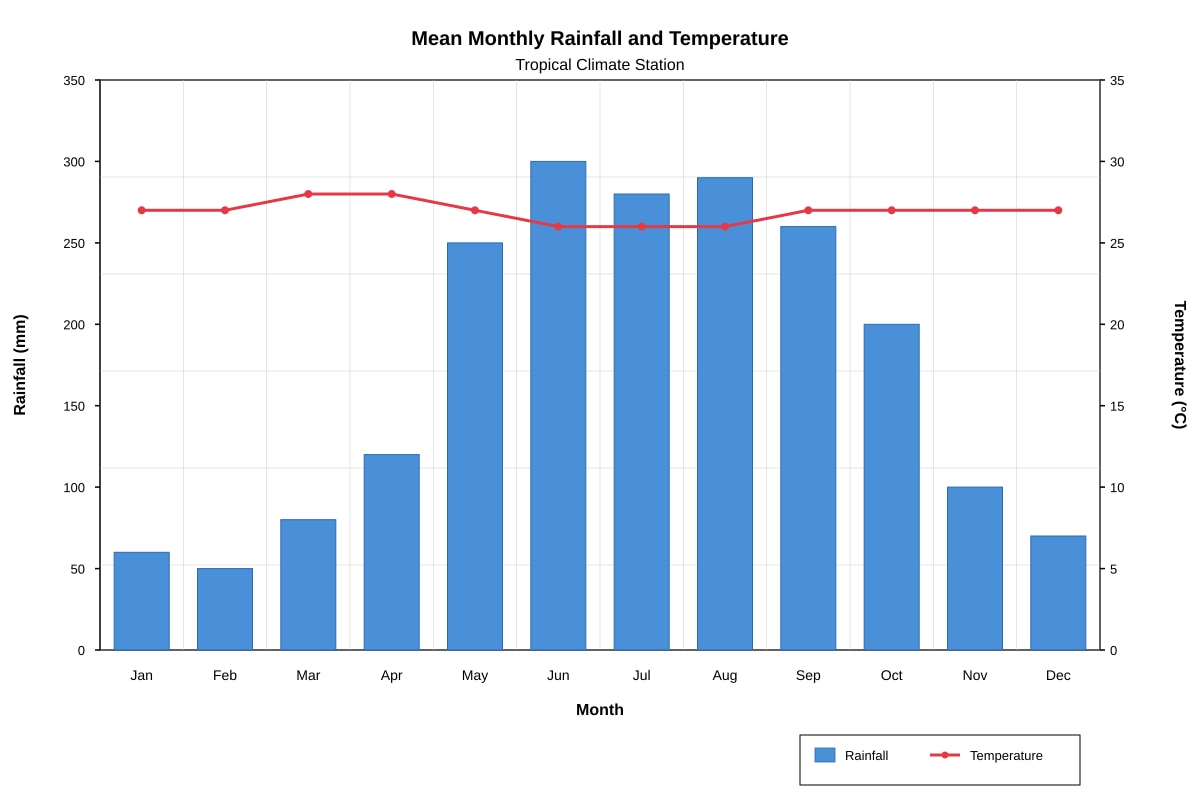
(a) Using the Köppen-Geiger system, identify the likely tropical climate zone represented by the climate graph above. Give a reason for your answer. [2]
Answer: Climate zone: Tropical Monsoon (Am) or Tropical Savanna (Aw).
Reason: The graph shows consistently high temperatures (26-28°C) throughout the year, indicating a tropical climate. However, rainfall is highly seasonal, with a distinct wet season (May-October) and a drier season (November-April). The dry season is not severe enough to be classified as savanna (if minimum monthly rainfall > 60mm in driest month, it would be Am; if less, it would be Aw). Based on the data (Jan 60mm, Feb 50mm), the driest month is below 60mm, suggesting Aw (Tropical Savanna).
Marking scheme:
- 1 mark for correct identification (Am or Aw, with preference for Aw based on data).
- 1 mark for valid reason (seasonal rainfall, high temperatures).
(b) Describe the likely characteristics of the natural vegetation found in this climate zone. [3]
Answer: The natural vegetation in a Tropical Savanna (Aw) climate is typically:
- Open grassland with scattered trees (savanna woodland).
- Trees are often deciduous, shedding leaves during the dry season to reduce water loss.
- Deep root systems to access groundwater during dry periods.
- Fire-resistant bark and adaptations to survive periodic bushfires.
- Tall grasses that die back in the dry season but regrow rapidly with the onset of rains.
Marking scheme:
- 1 mark for identifying savanna/grassland with scattered trees.
- 1 mark for describing deciduous nature or drought adaptations.
- 1 mark for any other valid characteristic (e.g., fire resistance, deep roots).
Question 15
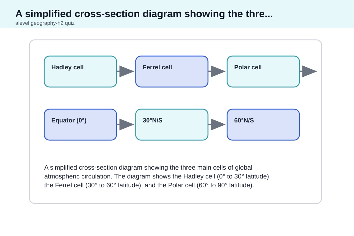
(a) Explain how the Hadley cell contributes to the distribution of tropical climates. [4]
Answer: The Hadley cell is a large-scale atmospheric circulation pattern that plays a key role in determining tropical climates:
-
At the equator (0°): Intense solar heating causes air to rise, creating a low-pressure zone (the ITCZ). Rising air cools and condenses, producing heavy rainfall. This creates the Tropical Rainforest (Af) climate near the equator, with high rainfall year-round.
-
At approximately 30° latitude: The rising air at the equator moves poleward, cools, and descends. Descending air is dry and creates high-pressure zones. This leads to arid conditions (deserts) at the tropics of Cancer and Capricorn, such as the Sahara and Australian deserts.
-
Between the equator and 30°: The descending limb of the Hadley cell creates seasonal variations in rainfall. As the ITCZ migrates north and south with the seasons, areas between 5°-15° experience wet and dry seasons, producing Tropical Monsoon (Am) and Tropical Savanna (Aw) climates.
-
Trade winds: The surface flow of the Hadley cell (trade winds) brings moisture from the oceans, influencing rainfall distribution on the eastern sides of continents.
Marking scheme:
- 1 mark for explaining rising air at equator and rainfall.
- 1 mark for explaining descending air at 30° and aridity.
- 1 mark for explaining seasonal migration of ITCZ and seasonal rainfall.
- 1 mark for any additional valid point (e.g., trade winds, pressure belts).
(b) State the term used for the zone where the trade winds converge near the equator. [1]
Answer: Intertropical Convergence Zone (ITCZ).
Marking notes: Accept full name or abbreviation.
Section C: Essay Questions (40 marks)
Question 16
With reference to one or more tropical river basins, evaluate the extent to which human activities have increased the risk of fluvial flooding. [10]
Answer:
Introduction: Fluvial flooding in tropical river basins is a natural phenomenon, but human activities have significantly increased the frequency and magnitude of flood events. This essay will evaluate the extent to which human activities, such as deforestation, urbanisation, and river engineering, have amplified flood risk, using examples from the Ganges-Brahmaputra basin and the Chao Phraya basin.
Body Paragraph 1: Deforestation Deforestation in the upper catchments of tropical rivers (e.g., the Himalayas for the Ganges) reduces interception storage and evapotranspiration. This leads to more rapid runoff and higher peak discharges. The removal of root systems also reduces soil cohesion, increasing erosion and sediment load, which can raise river beds and reduce channel capacity. In the Ganges basin, deforestation has contributed to more frequent and severe flooding downstream.
Body Paragraph 2: Urbanisation Urbanisation in floodplains (e.g., Bangkok in the Chao Phraya basin) replaces permeable surfaces with impermeable concrete and tarmac. This reduces infiltration and increases overland flow, shortening lag times and increasing peak discharge. Urban drainage systems often discharge directly into rivers, further concentrating flow. The 2011 Bangkok floods were exacerbated by rapid urban expansion and inadequate drainage infrastructure.
Body Paragraph 3: River Engineering River engineering, such as channel straightening, levee construction, and dam building, can paradoxically increase flood risk. Levees confine flow but can fail catastrophically. Dams trap sediment, reducing downstream sediment supply and causing riverbed incision, which can destabilise banks. Channel straightening increases flow velocity, transferring flood risk downstream. In the Mississippi (though not tropical), similar issues apply; in tropical basins, such as the Mekong, dam construction has altered flood regimes.
Body Paragraph 4: Agricultural Practices Agricultural drainage and land conversion (e.g., peatland drainage in Indonesia) reduce natural water storage. Drainage channels speed up water movement, increasing flood peaks. Burning of peatlands also reduces soil water retention capacity.
Counterargument: Natural Factors However, it is important to recognise that tropical climates naturally produce intense rainfall (e.g., monsoons, cyclones) that can cause flooding regardless of human activity. Climate change is also increasing rainfall intensity. In some cases, human activities such as wetland restoration and sustainable land management can reduce flood risk.
Conclusion: Overall, human activities have significantly increased flood risk in tropical river basins, particularly through deforestation, urbanisation, and river engineering. However, the extent varies by location and the intensity of human modification. Natural climatic variability remains a significant factor, and future flood management must integrate both natural and human dimensions.
Marking scheme (Levels-based):
- Level 4 (8-10 marks): Comprehensive evaluation with well-supported examples, balanced argument, and clear conclusion.
- Level 3 (6-7 marks): Good explanation of human activities with some examples, but limited evaluation.
- Level 2 (4-5 marks): Descriptive account of human activities with limited reference to flood risk.
- Level 1 (1-3 marks): Basic points with little development or relevance.
Question 17
Discuss the relative importance of climate and geology in influencing the development of karst landscapes in the humid tropics. [10]
Answer:
Introduction: Karst landscapes, characterised by sinkholes, caves, and limestone pavements, are formed by the chemical weathering of soluble rocks. In the humid tropics, both climate and geology play crucial roles. This essay will discuss their relative importance, arguing that while climate provides the necessary conditions, geology fundamentally determines the extent and nature of karst development.
Body Paragraph 1: Climate - Temperature and Rainfall The humid tropics are characterised by high temperatures (26-28°C) and high rainfall (often >2000mm/year). High temperatures accelerate chemical reactions, increasing the rate of carbonation. High rainfall provides abundant water, which is essential for dissolving limestone. The CO₂-rich rainwater, combined with organic acids from vegetation, creates a highly aggressive weathering environment. This is why karst landscapes in the tropics (e.g., Gunung Mulu in Sarawak) are often more spectacular than in temperate regions.
Body Paragraph 2: Climate - Vegetation and Biological Activity Dense tropical vegetation enhances weathering through root respiration and organic matter decomposition, producing high CO₂ concentrations in soil. This creates carbonic acid that aggressively dissolves limestone. The thick soil layer also retains moisture, prolonging chemical reactions.
Body Paragraph 3: Geology - Rock Type and Purity Geology is fundamental because karst only develops on soluble rocks, primarily limestone (calcium carbonate). The purity and thickness of the limestone are critical. Pure, thick limestone (e.g., in the Yucatán Peninsula) allows extensive cave systems to form. Impure limestone with clay or silica impurities weathers more slowly and produces less dramatic karst features.
Body Paragraph 4: Geology - Structure and Fractures The geological structure, including joints, faults, and bedding planes, controls the pathways of water infiltration. Water follows these fractures, concentrating dissolution along them. This creates grikes and clints on limestone pavements and controls the orientation of cave systems. In the tropics, intense tectonic activity (e.g., in Southeast Asia) can create complex fracture networks, enhancing karst development.
Body Paragraph 5: Relative Importance While climate provides the "engine" for weathering, geology provides the "raw material" and structure. Without soluble rock, no karst can form, regardless of climate. However, given suitable geology, a tropical climate accelerates karst development significantly. Thus, geology is the primary control, but climate is a crucial secondary factor that determines the rate and intensity of karstification.
Conclusion: In conclusion, both climate and geology are essential for karst development in the humid tropics. Geology is the fundamental control, determining whether karst can form and its overall structure. Climate, particularly high temperature and rainfall, accelerates the processes, making tropical karst landscapes among the most developed in the world. The relative importance varies by location, but geology is arguably more important as a prerequisite.
Marking scheme (Levels-based):
- Level 4 (8-10 marks): Balanced discussion with clear evaluation of relative importance, using specific examples.
- Level 3 (6-7 marks): Good explanation of both factors but limited evaluation.
- Level 2 (4-5 marks): Descriptive account of either climate or geology.
- Level 1 (1-3 marks): Basic points with little development.
Question 18
Explain how the hydrological cycle in a tropical rainforest drainage basin differs from that in a temperate deciduous forest drainage basin. [10]
Answer:
Introduction: The hydrological cycle describes the continuous movement of water between the atmosphere, land, and oceans. Tropical rainforest and temperate deciduous forest basins differ significantly in their hydrological processes due to differences in climate, vegetation, and soil. This essay will explain these differences.
Body Paragraph 1: Precipitation and Interception Tropical rainforests receive high annual rainfall (2000-4000mm) with high intensity, while temperate deciduous forests receive moderate rainfall (500-1500mm) with lower intensity. Tropical rainforests have dense, multi-layered canopies that intercept a higher proportion of rainfall (up to 25%) compared to temperate forests (10-20%). However, due to the sheer volume of rainfall, more water still reaches the ground in the tropics.
Body Paragraph 2: Evapotranspiration Tropical rainforests have high evapotranspiration rates due to high temperatures and abundant moisture. Trees transpire large volumes of water, returning it to the atmosphere. In temperate forests, evapotranspiration is lower and seasonal, with minimal transpiration in winter when trees are deciduous.
Body Paragraph 3: Infiltration and Throughflow Tropical rainforest soils are often deep and well-structured due to high biological activity (roots, burrowing animals). This creates macropores that enhance infiltration. However, intense rainfall can exceed infiltration capacity, causing overland flow. In temperate forests, infiltration is moderate, and throughflow is more significant due to seasonal rainfall patterns.
Body Paragraph 4: Overland Flow and Runoff In tropical rainforests, high-intensity rainfall can generate saturation overland flow, especially on slopes. However, the dense vegetation and leaf litter slow surface runoff. In temperate forests, overland flow is less common except during snowmelt or intense storms. River discharge in tropical basins is high year-round with less seasonal variation, while temperate basins show distinct seasonal peaks (e.g., spring snowmelt).
Body Paragraph 5: Groundwater and Baseflow Tropical rainforests have significant groundwater recharge due to high rainfall, sustaining baseflow in rivers. However, the high temperatures and rapid cycling of water mean that groundwater stores may be less significant relative to the total water flux. Temperate forests have more seasonal groundwater recharge, with baseflow dominating during dry summer months.
Conclusion: In summary, the hydrological cycle in tropical rainforest basins is characterised by higher fluxes (precipitation, evapotranspiration, runoff) and less seasonal variation compared to temperate deciduous forest basins. The dense vegetation and high temperatures create a more dynamic and rapid cycling of water in the tropics.
Marking scheme (Levels-based):
- Level 4 (8-10 marks): Comprehensive comparison with clear structure and specific details.
- Level 3 (6-7 marks): Good comparison but some aspects underdeveloped.
- Level 2 (4-5 marks): Descriptive account of one basin type.
- Level 1 (1-3 marks): Basic points with little development.
Question 19
With reference to one or more examples, assess the extent to which tropical cyclones (typhoons/hurricanes) are the most significant cause of flooding in the humid tropics. [10]
Answer:
Introduction: Flooding in the humid tropics is caused by a variety of factors, including intense monsoon rainfall, orographic rainfall, and tropical cyclones. This essay will assess the extent to which tropical cyclones are the most significant cause, using examples such as Typhoon Haiyan (Philippines, 2013) and Cyclone Nargis (Myanmar, 2008).
Body Paragraph 1: Tropical Cyclones as a Major Cause Tropical cyclones are intense low-pressure systems that bring extreme rainfall (often >500mm in 24 hours) and storm surges. Typhoon Haiyan caused devastating flooding in the Philippines, with storm surges of up to 7m and rainfall exceeding 300mm. Cyclone Nargis caused catastrophic flooding in the Irrawaddy Delta, with storm surges inundating low-lying areas. These events demonstrate the destructive potential of cyclones.
Body Paragraph 2: Monsoon Rainfall However, monsoon rainfall is arguably a more frequent and widespread cause of flooding in the humid tropics. The South Asian monsoon, for example, brings sustained heavy rainfall over weeks or months, causing river flooding across the Ganges-Brahmaputra basin. The 2017 South Asian floods affected millions of people, with rainfall exceeding 300% of normal in some areas. Monsoon floods are more predictable but affect larger areas over longer periods.
Body Paragraph 3: Orographic and Convective Rainfall Localised convective storms and orographic rainfall (where moist air is forced up mountains) can also cause flash flooding. In Southeast Asia, intense afternoon thunderstorms can cause rapid river rises. These events are less predictable but can be locally severe.
Body Paragraph 4: Human Factors Human activities, such as deforestation and urbanisation, can amplify flood risk regardless of the meteorological cause. In the Philippines, deforestation in upland areas increased runoff and sediment load, worsening the impacts of Typhoon Haiyan. In Myanmar, the loss of mangrove forests reduced natural coastal protection against storm surges.
Body Paragraph 5: Assessment While tropical cyclones can cause the most extreme and sudden flooding, they are relatively infrequent and affect specific coastal regions. Monsoon rainfall is a more persistent and widespread cause of flooding, affecting millions of people annually. Therefore, cyclones are significant but not necessarily the most significant cause overall. The relative importance varies by region and time.
Conclusion: In conclusion, tropical cyclones are a dramatic and destructive cause of flooding in the humid tropics, but they are not the most significant in terms of frequency and areal extent. Monsoon rainfall is a more persistent and widespread cause. Human activities further complicate the picture by amplifying flood risk. Therefore, while cyclones are important, they are not the most significant cause of flooding in the humid tropics overall.
Marking scheme (Levels-based):
- Level 4 (8-10 marks): Well-balanced assessment with specific examples and clear evaluation.
- Level 3 (6-7 marks): Good explanation of cyclones but limited comparison with other causes.
- Level 2 (4-5 marks): Descriptive account of cyclone impacts.
- Level 1 (1-3 marks): Basic points with little development.
Question 20
Evaluate the view that tropical climates are best defined by temperature rather than rainfall. [10]
Answer:
Introduction: The definition of tropical climates is a matter of ongoing debate. While temperature is a fundamental characteristic, rainfall patterns are often used to subdivide tropical climates. This essay will evaluate the view that temperature is the best defining criterion, considering both temperature and rainfall.
Body Paragraph 1: Temperature as a Defining Criterion Temperature is a consistent and reliable indicator of tropical climates. The tropics are defined as the region between the Tropic of Cancer (23.5°N) and the Tropic of Capricorn (23.5°S), where the sun is directly overhead at least once a year. This results in high solar insolation and consistently high temperatures (mean monthly >18°C). Temperature is relatively uniform throughout the year, with a small annual range (often <5°C). This consistency makes temperature a clear and unambiguous criterion.
Body Paragraph 2: Rainfall as a Defining Criterion Rainfall, however, varies greatly within the tropics. Some tropical areas, such as the Amazon rainforest, receive over 3000mm of rain annually, while others, such as the Sahara Desert, receive less than 100mm. This variability means that rainfall alone cannot define a tropical climate. However, rainfall seasonality is used to subdivide tropical climates into Af (rainforest), Am (monsoon), and Aw (savanna) in the Köppen-Geiger system.
Body Paragraph 3: The Case for Temperature Temperature is a more fundamental defining criterion because it determines the energy balance and drives atmospheric circulation. High temperatures cause air to rise, creating low pressure and rainfall. Temperature also influences evapotranspiration rates and biological activity. A region with high temperatures but low rainfall (e.g., the Sahara) is still classified as tropical (BWh) in some systems, whereas a region with moderate temperatures but high rainfall (e.g., the UK) is not tropical.
**Body Paragraph 4: The Case
<stage3_quiz_answers_md>
A-Level Geography H2 Quiz - Physical Geography: ANSWER KEY
Total Marks: 100
Section A: Short Answer Questions (20 marks)
1. Define the term drainage basin. [2]
Answer: A drainage basin is the area of land drained by a river and its tributaries. It is an open system with inputs, outputs, stores, and flows of water.
2. State two inputs and two outputs in the drainage basin hydrological cycle. [4]
| Inputs | Outputs |
|---|---|
| (i) Precipitation (rain, snow, etc.) | (i) Evaporation |
| (ii) Condensation (on surfaces) | (ii) Transpiration |
| (Accept: solar energy as an input) | (Accept: River discharge / runoff to sea) |
3. Identify the three main types of tropical climate zones according to the Köppen-Geiger classification based on rainfall amount and seasonality. [3]
(i) Tropical Rainforest (Af) – no dry season (ii) Tropical Monsoon (Am) – short dry season (iii) Tropical Savanna (Aw) – distinct dry season in winter
4. Briefly distinguish between throughflow and baseflow as pathways of water movement in a drainage basin. [3]
Answer: Throughflow is the lateral movement of water within the soil layer (the unsaturated zone), moving downslope towards the river channel. Baseflow is the movement of water through the deeper bedrock (groundwater store) that feeds the river channel slowly over a long period, maintaining river flow during dry periods.
5. Name the geomorphic process by which soluble rock, such as limestone, is dissolved by acidic water. [1]
Answer: Carbonation (or solution/corrosion)
6. Explain the role of interception storage in the hydrological cycle. [3]
Answer: Interception storage is the temporary retention of precipitation on vegetation surfaces (leaves, branches, stems) before it reaches the ground. This water can be evaporated directly back into the atmosphere (interception loss), reducing the amount of water that reaches the ground for infiltration and runoff. It also delays the arrival of water at the ground surface, reducing peak discharge and increasing lag time.
7. State two human factors that can increase the risk of fluvial flooding in the humid tropics. [2]
(i) Deforestation (removal of forest cover reduces interception and infiltration, increasing surface runoff) (ii) Urbanisation (creation of impervious surfaces like concrete and tarmac reduces infiltration, increasing surface runoff and reducing lag time)
8. What is the key distinguishing climatic characteristic of the tropics? [1]
Answer: High mean annual temperature (typically >18°C) with minimal seasonal variation in temperature.
9. Define mass movement and identify one type of mass movement that involves very slow movement of soil down a slope. [2]
Answer: Mass movement is the downslope movement of weathered material (regolith) under the influence of gravity. Type: Soil creep (or solifluction)
10. Explain how vegetation cover affects the rate of infiltration in a drainage basin. [3]
Answer: Dense vegetation cover generally increases infiltration rates. Plant roots create channels and macropores in the soil, improving soil structure and porosity. The leaf litter layer (organic matter) also absorbs rainfall and protects the soil surface from compaction by raindrop impact. This allows water to enter the soil more easily. Conversely, sparse or absent vegetation leads to soil compaction and surface crusting, reducing infiltration.
Section B: Data-Response Questions (40 marks)
Question 11
(a) Identify the pathway labelled X that represents the lateral movement of water within the soil layer. [1]
Answer: Throughflow
(b) Explain two natural factors that could reduce the amount of overland flow shown in the diagram. [4]
Answer:
- High infiltration capacity: If the soil is permeable (e.g., sandy soil) and has high porosity, water can infiltrate rapidly, reducing the amount of water that flows over the surface as overland flow.
- Dense vegetation cover: Forest canopy intercepts rainfall, and leaf litter on the forest floor absorbs water. This reduces the intensity of rainfall reaching the ground and increases the time for infiltration, thereby reducing overland flow.
Question 12
(a) Compare the peak discharge and lag time between Basin A and Basin B. [2]
Answer: Basin A has a higher peak discharge (1200 m³/s) and a shorter lag time (4 hours) compared to Basin B, which has a lower peak discharge (800 m³/s) and a longer lag time (12 hours).
(b) Explain why the differences in land use between Basin A and Basin B account for the observed differences in flood response. [4]
Answer: Basin A is urban with 70% impervious surfaces (concrete, tarmac). This prevents infiltration, so most rainfall becomes overland flow, quickly reaching the river channel. This results in a high peak discharge and short lag time. Basin B is 90% forested. Dense vegetation intercepts rainfall, and the forest floor has high infiltration capacity. Water moves more slowly through the soil as throughflow, and some is stored as groundwater. This delays the arrival of water to the river, resulting in a lower peak discharge and longer lag time.
Question 13
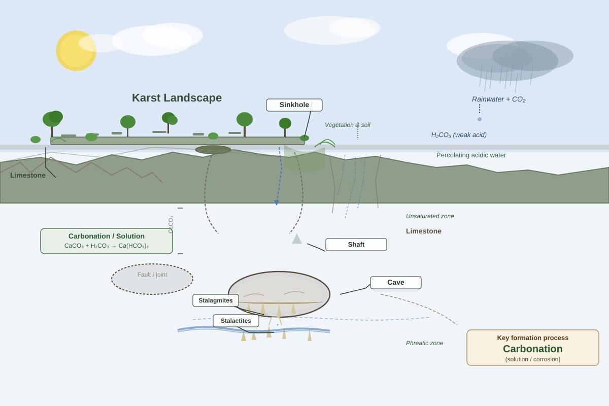
(a) Refer to the figure above showing a karst landscape. Identify the process primarily responsible for the formation of the sinkhole and underground cave. [1]
Generated figure for this question.
Answer: Carbonation (or solution/corrosion) – the chemical weathering of limestone by weakly acidic rainwater.
(b) Explain the role of vegetation and soil in enhancing chemical weathering on a limestone pavement. [4]
Answer: Vegetation (e.g., mosses, lichens, and plants) and soil enhance chemical weathering in two main ways:
- Production of organic acids: Decomposing organic matter from plants releases humic acids and other organic acids into the soil water. This increases the acidity of the water, making it more effective at dissolving limestone.
- Increased CO₂ concentration: Respiration by plant roots and soil organisms releases carbon dioxide (CO₂) into the soil. This CO₂ dissolves in soil water to form carbonic acid (H₂CO₃), which is the primary agent of carbonation on limestone.
Question 14
(a) Using the Köppen-Geiger system, identify the likely tropical climate zone represented by the climate graph above. Give a reason for your answer. [2]
Answer: Climate zone: Tropical Monsoon (Am) Reason: The graph shows consistently high temperatures (26-28°C) throughout the year, indicating a tropical climate. Rainfall is high but seasonal, with a distinct wet season (May-October) and a short dry season (November-April). The total annual rainfall is high enough to support rainforest, but the presence of a short dry season distinguishes it from the Tropical Rainforest (Af) climate.
(b) Describe the likely characteristics of the natural vegetation found in this climate zone. [3]
Answer: The natural vegetation is likely tropical semi-evergreen or monsoon forest. Characteristics include:
- A mix of evergreen and deciduous tree species.
- Trees may lose their leaves during the short dry season to conserve water.
- The forest is generally tall and dense, but may have a more open canopy than a true rainforest.
- High biodiversity, but slightly less than a tropical rainforest.
Question 15
(a) Explain how the Hadley cell contributes to the distribution of tropical climates. [4]
Answer: The Hadley cell is a global atmospheric circulation cell that operates between the equator and approximately 30° latitude. At the equator, intense solar heating causes air to rise, creating a low-pressure zone (the Intertropical Convergence Zone, ITCZ). This rising air cools and condenses, producing heavy rainfall, which gives rise to tropical rainforest climates (Af). The rising air then moves poleward at high altitude, cooling and sinking around 30° latitude. This descending air creates high-pressure zones, suppressing cloud formation and rainfall, leading to the formation of tropical deserts and savanna climates (Aw) on the poleward margins of the tropics.
(b) State the term used for the zone where the trade winds converge near the equator. [1]
Answer: Intertropical Convergence Zone (ITCZ)
Section C: Essay Questions (40 marks)
16. With reference to one or more tropical river basins, evaluate the extent to which human activities have increased the risk of fluvial flooding. [10]
Model Answer:
Human activities have significantly increased the risk of fluvial flooding in many tropical river basins, but the extent varies depending on the specific activity, the basin's characteristics, and the scale of intervention.
Activities that increase flood risk:
- Deforestation: In the Amazon basin, large-scale deforestation for agriculture and cattle ranching has reduced interception and evapotranspiration. This increases surface runoff, leading to higher peak discharges and shorter lag times during rainfall events. The removal of forest cover also reduces soil infiltration capacity, exacerbating overland flow.
- Urbanisation: In rapidly growing cities like Jakarta (Indonesia) or Manila (Philippines), the conversion of permeable surfaces to impervious concrete and tarmac prevents infiltration. Storm drains quickly channel water into rivers, causing flashier flood responses. Urbanisation also often encroaches on floodplains, reducing the natural storage capacity of the river system.
- Agricultural practices: In the Ganges-Brahmaputra delta, intensive rice cultivation and the construction of embankments can alter drainage patterns. Over-irrigation can raise water tables, reducing the soil's capacity to absorb rainfall. The removal of natural vegetation for cash crops also increases runoff.
- River engineering: Channelisation, straightening, and the construction of levees in many tropical rivers (e.g., the Mekong) can increase flood risk downstream by speeding up water flow and reducing natural floodplain storage.
Limitations and counterarguments:
- Natural factors are still dominant: Extreme rainfall events associated with tropical cyclones or the monsoon remain the primary trigger for major floods. Human activities often exacerbate the impact of these natural events, but they do not cause them.
- Mitigation measures: Some human activities can reduce flood risk. The construction of dams and reservoirs (e.g., on the Mekong) can regulate river flow and store floodwater. Reforestation and sustainable land management practices can restore some of the natural hydrological functions of a basin.
- Scale and context: The impact of human activities varies greatly. In a small, heavily urbanised basin, the effect on flood risk is dramatic. In a large, relatively undisturbed basin, the impact may be less pronounced.
Conclusion: Human activities have undoubtedly increased the risk of fluvial flooding in many tropical river basins, particularly through deforestation and urbanisation. However, the extent of this increase is highly variable and is often mediated by natural factors and the implementation of mitigation measures. It is an important contributing factor, but not the sole cause of increased flood risk.
17. Discuss the relative importance of climate and geology in influencing the development of karst landscapes in the humid tropics. [10]
Model Answer:
Both climate and geology are crucial for the development of karst landscapes, but their relative importance varies. In the humid tropics, climate is often the dominant factor, but geology provides the essential foundation.
Importance of Climate:
- High rainfall: The humid tropics receive high annual rainfall (often >2000mm). This provides abundant water for chemical weathering. The high intensity of rainfall also promotes rapid dissolution of limestone.
- High temperatures: High mean annual temperatures (26-28°C) accelerate chemical reactions. The rate of carbonation (the dissolution of limestone by carbonic acid) approximately doubles for every 10°C rise in temperature. This makes the humid tropics the most favourable environment for karst development.
- High CO₂ levels: Warm, moist conditions promote high rates of biological activity (plant growth, decomposition), which increases the concentration of CO₂ in the soil. This enhances the formation of carbonic acid, making rainwater more aggressive in dissolving limestone.
Importance of Geology:
- Lithology: Karst landscapes can only develop on soluble rocks, primarily limestone (calcium carbonate) and dolomite. The rock must be pure, thick, and well-jointed to allow water to penetrate and dissolve it. Without suitable geology, karst cannot form, regardless of climate.
- Structure: The presence of joints, faults, and bedding planes in the limestone provides pathways for water to enter the rock. These structural weaknesses are exploited by chemical weathering, leading to the formation of grikes, clints, sinkholes, and cave systems.
- Permeability: Limestone is permeable due to its joints and fractures (secondary permeability). This allows water to infiltrate and circulate underground, creating the characteristic subsurface drainage of karst landscapes.
Relative Importance:
- Climate is the driver: In the humid tropics, the combination of high rainfall and high temperatures creates an extremely aggressive chemical weathering environment. This accelerates the development of karst features compared to temperate or arid regions. The same limestone in a cold or dry climate would develop karst much more slowly.
- Geology is the prerequisite: Without soluble, well-jointed limestone, karst cannot develop, regardless of climate. Geology determines the location and potential for karst formation.
- Interaction: The two factors are interdependent. The high rainfall of the humid tropics is most effective when it falls on well-jointed limestone. The high CO₂ levels from biological activity are only significant if the rock is soluble.
Conclusion: While geology is the essential prerequisite for karst development (providing the soluble rock and structure), climate is the dominant factor in the humid tropics. The high temperatures and abundant rainfall create the most aggressive chemical weathering environment on Earth, accelerating the formation of karst features to a much greater extent than in other climates. Therefore, in the humid tropics, climate is arguably more important than geology in determining the rate and intensity of karst landscape development.
18. Explain how the hydrological cycle in a tropical rainforest drainage basin differs from that in a temperate deciduous forest drainage basin. [10]
Model Answer:
The hydrological cycle in a tropical rainforest drainage basin differs significantly from that in a temperate deciduous forest basin due to differences in climate, vegetation, and soil characteristics.
Key Differences:
- Precipitation: Tropical rainforests receive high, often intense, rainfall throughout the year (e.g., >2000mm annually), with little seasonality. Temperate deciduous forests receive moderate rainfall (e.g., 750-1500mm annually), often with a distinct seasonal pattern (e.g., wetter winters).
- Interception: Tropical rainforests have a much higher interception capacity due to their multi-layered canopy and dense foliage. A significant proportion of rainfall (up to 20-30%) is intercepted and evaporated back to the atmosphere. Temperate deciduous forests have lower interception, especially in winter when trees are leafless.
- Evapotranspiration: Tropical rainforests have very high rates of evapotranspiration due to high temperatures, high humidity, and dense vegetation. This returns a large amount of water to the atmosphere. Temperate forests have lower evapotranspiration rates, particularly in winter when temperatures are low and trees are dormant.
- Infiltration and Runoff: Tropical rainforest soils are often deep, well-structured, and highly permeable due to the activity of roots and soil organisms. This promotes high infiltration rates and reduces overland flow. Temperate forest soils can also be permeable, but may be more prone to saturation in winter, leading to increased overland flow.
- Throughflow and Baseflow: In tropical rainforests, throughflow is a major pathway due to the high infiltration and the presence of a thick, porous soil layer. Baseflow is also significant, maintaining river flow during dry periods. In temperate forests, throughflow is important, but baseflow may be more variable, depending on the season and the underlying geology.
- Seasonality: The tropical rainforest cycle is relatively constant throughout the year, with high inputs and outputs. The temperate forest cycle is highly seasonal, with higher inputs in winter (rain/snow) and higher outputs (evapotranspiration) in summer.
Conclusion: The tropical rainforest hydrological cycle is characterised by high, constant inputs and outputs, with interception and evapotranspiration playing a much larger role than in temperate forests. The temperate forest cycle is more seasonal, with greater variation in precipitation, evapotranspiration, and runoff between summer and winter. These differences reflect the contrasting climatic and vegetation conditions of the two biomes.
19. With reference to one or more examples, assess the extent to which tropical cyclones (typhoons/hurricanes) are the most significant cause of flooding in the humid tropics. [10]
Model Answer:
Tropical cyclones are a major cause of flooding in the humid tropics, but they are not the only significant cause. The extent to which they are the most significant varies by region and time scale.
Evidence for cyclones as a major cause:
- Extreme rainfall: Cyclones bring intense, prolonged rainfall over large areas. For example, Hurricane Harvey (2017) in Texas dumped over 1500mm of rain in some areas, causing catastrophic flooding. Typhoon Morakot (2009) in Taiwan brought over 2500mm of rain, triggering massive landslides and floods.
- Storm surge: Cyclones generate a storm surge, a rise in sea level that can inundate coastal areas. This was a major cause of flooding during Hurricane Katrina (2005) in New Orleans and Cyclone Nargis (2008) in Myanmar.
- High frequency in some regions: The western North Pacific (e.g., Philippines, Japan, China) and the Bay of Bengal (e.g., Bangladesh, India) experience a high frequency of cyclones, making them a recurring cause of flooding.
Other significant causes of flooding:
- Monsoon rainfall: In South and Southeast Asia, the monsoon brings prolonged, heavy rainfall over several months. This can cause widespread river flooding, often affecting larger areas than individual cyclones. The 2022 Pakistan floods, which affected millions, were primarily caused by monsoon rainfall.
- Convective storms: Intense, localised thunderstorms can produce flash flooding in urban areas or steep terrain. These events are common in the humid tropics but are less predictable than cyclones.
- Human activities: Deforestation, urbanisation, and poor land management can exacerbate flooding from any rainfall event, making them a significant contributing factor.
- La Niña: The La Niña phase of the ENSO cycle is associated with increased rainfall in many parts of the tropics, leading to a higher risk of flooding.
Assessment:
- Cyclones are the most significant cause in terms of extreme, short-duration events. They produce the highest rainfall intensities and storm surges, leading to the most catastrophic floods.
- Monsoon rainfall is the most significant cause in terms of total area affected and duration. It causes widespread, long-lasting river flooding that can affect millions of people.
- Human activities are the most significant cause in terms of increasing vulnerability. They amplify the impact of all types of rainfall events.
Conclusion: Tropical cyclones are a very significant cause of flooding in the humid tropics, particularly for extreme, high-impact events. However, monsoon rainfall is arguably more significant in terms of the total area and number of people affected over longer periods. The most significant cause of flooding is often a combination of natural rainfall events and human activities that increase vulnerability. Therefore, cyclones are not universally the most significant cause, but they are a major one.
20. Evaluate the view that tropical climates are best defined by temperature rather than rainfall. [10]
Model Answer:
The view that tropical climates are best defined by temperature rather than rainfall has some merit, but it is an oversimplification. Both temperature and rainfall are essential for a complete definition.
Arguments for temperature as the primary defining factor:
- Consistency: The most consistent feature of tropical climates is high temperature throughout the year. The mean monthly temperature is always above 18°C, and the annual temperature range is small (often <5°C). This is a clear, measurable, and universal characteristic.
- Energy basis: Temperature is a direct measure of solar energy input. The tropics receive the most direct solar radiation, which drives the global climate system. This high energy input is the fundamental cause of the high temperatures and the intense hydrological cycle.
- Simplicity: A temperature-based definition is simple and easy to apply. It clearly distinguishes the tropics from temperate and polar regions.
Arguments for rainfall as an equally important defining factor:
- Variability: While temperature is consistent, rainfall is highly variable within the tropics. This variability creates distinct climate zones (e.g., rainforest, monsoon, savanna) that are defined by rainfall amount and seasonality. A temperature-only definition would lump these very different climates together.
- Ecological significance: Rainfall is the primary factor determining the type of vegetation and ecosystems found in the tropics. The difference between a tropical rainforest (Af) and a tropical savanna (Aw) is entirely due to rainfall, not temperature.
- Human impact: Rainfall variability has a much greater impact on human activities (e.g., agriculture, water resources, flood risk) than the small temperature variations within the tropics. Droughts and floods are major hazards in the tropics, and they are driven by rainfall patterns.
- Köppen-Geiger system: The most widely used climate classification system (Köppen-Geiger) uses both temperature and rainfall to define climate zones. The tropical (A) group is defined by temperature (mean monthly >18°C), but the subgroups (Af, Am, Aw) are defined by rainfall.
Evaluation:
- Temperature is the best single defining factor for the broadest category. It is the most consistent and fundamental characteristic of the tropics.
- Rainfall is essential for a more detailed and useful classification. It is the key factor that distinguishes between different types of tropical climates and has the greatest ecological and human impact.
- A combined definition is best. The most accurate and useful definition of tropical climates is one that includes both temperature (high, consistent) and rainfall (variable, seasonal). The Köppen-Geiger system provides a good model for this.
Conclusion: The view that tropical climates are best defined by temperature is partially correct, as temperature is the most consistent and fundamental characteristic. However, it is an oversimplification. Rainfall is equally important for distinguishing between different tropical climate types and for understanding their ecological and human significance. A complete definition of tropical climates must include both temperature and rainfall.