From Real Exams Quiz
A Level H2 Geography Physical Geography Quiz
Free A Level H2 Geography Physical Geography quiz, Exam version, with questions, answers, and A Level-style practice for Singapore students.
These static practice materials are generated from the site's syllabus and paper-generation workflow, with source and model context shown so students and parents can evaluate the material before use.
Questions
Free quiz and exam paper access
Enter your details to view this paper
Your access is remembered on this device.
Answers
A-Level Geography H2 Quiz - Physical Geography: Answer Key
Total Marks: 50
Section A: Tropical Climates and Drainage Basins (Questions 1–10)
1. [1 mark]
Answer: High temperatures (or consistently high temperatures throughout the year).
Teaching Note: The tropics are defined by their temperature regime, not just rainfall. All tropical climates have mean monthly temperatures above 18°C. This is the key distinguishing characteristic that separates tropical climates from temperate or polar climates.
Marking Note: Accept "high temperatures" or "mean monthly temperature > 18°C". Do not accept "rainfall" as the key characteristic.
2. [3 marks]
Answer:
- Tropical rainforest (Af)
- Tropical monsoon (Am)
- Tropical savanna (Aw)
Teaching Note: The humid tropics are divided into three Köppen-Geiger classifications based on rainfall patterns. Af has no dry season (rainfall > 60mm every month), Am has a short dry season but sufficient rainfall to support rainforest, and Aw has a distinct dry season in winter.
Marking Note: 1 mark for each correct classification. Must use correct Köppen letters (Af, Am, Aw) or full names.
3. [4 marks]
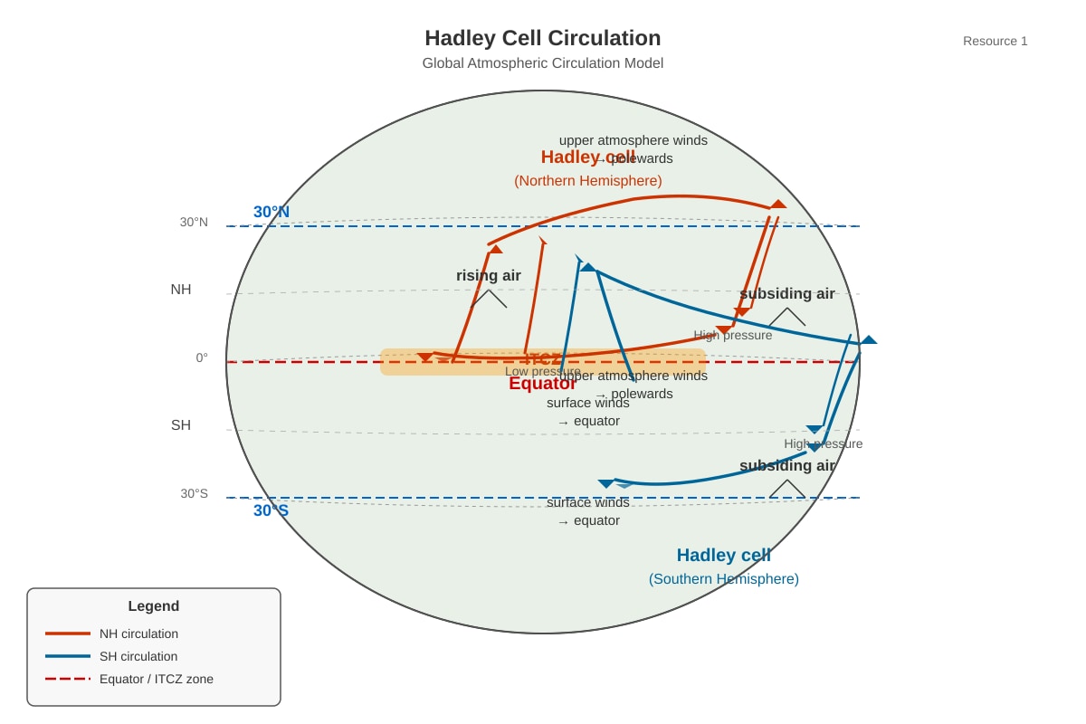
Answer: The seasonal migration of the Hadley cell causes the Intertropical Convergence Zone (ITCZ) to move north and south of the equator following the sun's zenithal position. [1]
When the ITCZ is overhead, the region experiences rising air, cloud formation, and heavy convectional rainfall (the wet season). [1]
When the ITCZ moves away, the region comes under the influence of subsiding air from the subtropical high-pressure belt, resulting in dry conditions (the dry season). [1]
This seasonal alternation between wet and dry periods creates the distinct wet and dry seasons characteristic of the tropical savanna (Aw) climate. [1]
Teaching Note: The key concept is that the Aw climate zone lies at the margins of the ITCZ's migration path. It experiences rainfall only when the ITCZ is overhead. When the ITCZ moves to the opposite hemisphere, the region is influenced by dry, subsiding air.
Marking Note: Award marks for: (1) ITCZ migration, (2) wet season mechanism, (3) dry season mechanism, (4) link to Aw climate seasonality.
4. [3 marks]
Answer: At the equator, intense solar heating causes air to rise, creating a zone of low pressure at the surface (the ITCZ). [1]
The rising air moves polewards in the upper atmosphere, cools, and subsides at approximately 30°N and 30°S. [1]
This subsidence creates zones of high pressure at the surface (subtropical high-pressure belts). [1]
Teaching Note: The Hadley cell is a closed circulation loop. Rising air = low pressure (convergence). Subsiding air = high pressure (divergence). Students should connect the vertical movement of air to surface pressure conditions.
Marking Note: 1 mark for each correct point. Must link rising air to low pressure and subsiding air to high pressure.
5. [2 marks]
Answer:
- Sea surface temperatures of at least 26–27°C (to a depth of about 60m)
- Coriolis force sufficient to initiate rotation (typically at least 5° from the equator)
Teaching Note: Tropical cyclones require warm ocean water to provide energy through evaporation and latent heat release. They also require the Coriolis effect to spin the developing system. Other conditions include low vertical wind shear and a pre-existing disturbance.
Marking Note: 1 mark for each correct condition. Accept other valid conditions such as "low vertical wind shear" or "high humidity in the lower troposphere".
6. [4 marks]
(a) [2 marks]
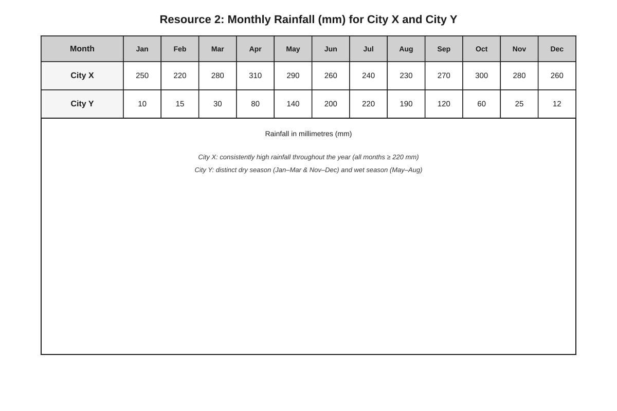
Answer: City X is likely to have a tropical monsoon (Am) climate. [1] Reason: It receives very high rainfall throughout the year (220–310 mm/month) with no month below 60 mm, but there is a slight dip in rainfall during June–August, indicating a short dry season. [1]
Teaching Note: The Am climate has a short dry season but receives enough total rainfall to support rainforest vegetation. City X's rainfall pattern shows consistently high rainfall with a slight seasonal variation.
(b) [2 marks]
Answer: City Y is likely to have a tropical savanna (Aw) climate. [1] Reason: It has a distinct dry season (November–March with rainfall below 30 mm) and a wet season (June–August with rainfall above 190 mm). [1]
Teaching Note: The Aw climate has a pronounced dry season during the low-sun period. City Y shows this pattern clearly, with very low rainfall for five months and high rainfall for three months.
Marking Note: Award 1 mark for correct identification and 1 mark for appropriate reasoning referencing the data.
7. [1 mark]
Answer: B) Decreased rainfall and lower sea surface temperatures
Teaching Note: During El Niño, the trade winds weaken, allowing warm water to shift eastwards across the Pacific. This causes the western Pacific (near Southeast Asia and Australia) to experience cooler sea surface temperatures and reduced rainfall, often leading to drought conditions.
Marking Note: 1 mark for correct option. No marks for other options.
8. [1 mark]
Answer: Interception storage is the water that is temporarily held on the surfaces of vegetation (leaves, branches, stems) before it reaches the ground.
Teaching Note: Interception is a key storage component in the drainage basin water balance. It delays the arrival of precipitation at the ground surface and can be evaporated directly back to the atmosphere.
Marking Note: Accept any definition that includes "water held on vegetation surfaces".
9. [4 marks]
Answer: Urbanisation increases the risk of fluvial flooding through several mechanisms:
-
Reduced infiltration: Impermeable surfaces (concrete, tarmac) prevent water from infiltrating into the ground, increasing surface runoff. [1]
-
Reduced interception: Removal of vegetation reduces interception storage, allowing more water to reach the ground quickly. [1]
-
Artificial drainage systems: Storm drains and channels transfer water rapidly to rivers, reducing lag time and increasing peak discharge. [1]
-
Channel modification: River channels may be narrowed or straightened, reducing channel capacity and increasing flood risk during high flows. [1]
Teaching Note: The key concept is that urbanisation alters the drainage basin's hydrological response by reducing storage and increasing the speed and volume of runoff reaching rivers. This leads to higher peak discharges and shorter lag times.
Marking Note: Award 1 mark for each well-explained mechanism. Accept other valid points such as "compaction of soil reducing infiltration" or "increased sediment load reducing channel capacity".
10. [4 marks]
Answer: Strategy 1: Construction of flood control dams/reservoirs
- Limitation: High construction costs and displacement of communities; reservoirs may silt up over time, reducing storage capacity. [1]
Strategy 2: River channelisation (straightening and deepening)
- Limitation: Can increase flood risk downstream by transferring water more quickly; may damage aquatic ecosystems. [1]
Alternative strategies (accept any two):
- Flood warning systems – Limitation: Requires reliable technology and community preparedness; may not reach all vulnerable groups.
- Afforestation/reforestation – Limitation: Takes time to establish; may compete with land for agriculture or development.
- Land-use zoning (restricting development on floodplains) – Limitation: May be difficult to enforce; conflicts with economic development needs.
- Building raised houses/stilts – Limitation: Does not prevent flooding, only reduces damage; may not be affordable for all.
Teaching Note: Students should demonstrate understanding that no single strategy is perfect. Effective flood management often requires a combination of structural (engineering) and non-structural (policy, community-based) approaches.
Marking Note: Award 1 mark for each strategy and 1 mark for each associated limitation (2 strategies × 2 marks = 4 marks total).
Section B: Landforms in the Tropics (Questions 11–20)
11. [2 marks]
Answer: Chemical weathering involves the chemical decomposition of rocks through reactions with water, oxygen, or acids, altering the mineral composition of the rock. [1]
Physical (mechanical) weathering involves the physical disintegration of rocks into smaller fragments without changing their chemical composition. [1]
Teaching Note: The key distinction is that chemical weathering changes the chemical structure of minerals (e.g., feldspar → clay), while physical weathering only breaks rocks into smaller pieces (e.g., freeze-thaw cracking).
Marking Note: 1 mark for each correct definition. Must clearly distinguish between chemical change and physical breakage.
12. [1 mark]
Answer: Carbonation
Teaching Note: Carbonation is the reaction between carbonic acid (formed when CO₂ dissolves in rainwater) and calcium carbonate (CaCO₃) in limestone. The reaction produces soluble calcium bicarbonate, which is removed in solution: CaCO₃ + H₂CO₃ → Ca(HCO₃)₂
Marking Note: Accept "carbonation" only. Do not accept "solution" (which is the removal process, not the chemical reaction).
13. [5 marks]
Answer: Rainwater absorbs carbon dioxide from the atmosphere and soil to form weak carbonic acid (H₂CO₃). [1]
This weak acid reacts with calcium carbonate (CaCO₃) in the limestone through the process of carbonation, producing soluble calcium bicarbonate [Ca(HCO₃)₂]. [1]
The calcium bicarbonate is removed in solution, dissolving the limestone along lines of weakness. [1]
Joints (vertical cracks) and bedding planes (horizontal layers) in the limestone provide pathways for water to penetrate and dissolve the rock. [1]
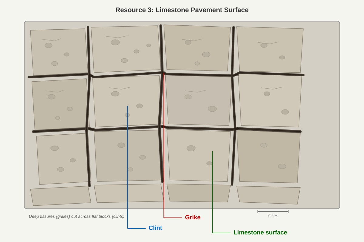
Over time, the widening of joints by carbonation and solution creates deep fissures called grikes, while the remaining flat blocks of limestone are called clints. [1]
Teaching Note: The formation of limestone pavements requires both the chemical process (carbonation) and the removal process (solution). The pre-existing joint pattern controls where dissolution occurs, creating the characteristic grid-like pattern of grikes and clints.
Marking Note: Award marks for: (1) formation of carbonic acid, (2) carbonation reaction, (3) solution removal, (4) role of joints/bedding planes, (5) formation of grikes and clints.
14. [2 marks]
Answer: Pressure release occurs when overlying rock is removed by erosion, reducing the confining pressure on the underlying rock. [1]
The rock expands outward (especially along joints parallel to the surface), causing it to crack and peel away in curved sheets or slabs (exfoliation). [1]
Teaching Note: Pressure release is common in granitic landscapes where deep weathering has occurred. The removal of overburden allows the rock to expand, creating sheet joints. This is also called "sheeting" or "exfoliation".
Marking Note: 1 mark for explaining the cause (removal of overlying pressure) and 1 mark for describing the effect (expansion and cracking).
15. [3 marks]
Answer: Joints and bedding planes are lines of weakness in limestone that provide pathways for water to penetrate the rock. [1]
Water containing dissolved CO₂ (carbonic acid) flows along these pathways, increasing the surface area of rock exposed to chemical weathering. [1]
This accelerates the rate of carbonation and solution because chemical weathering occurs more rapidly along these zones of weakness, widening them over time and creating features such as grikes, caves, and underground drainage systems. [1]
Teaching Note: The presence of joints and bedding planes is crucial for karst landscape development. Without them, water would only dissolve the surface of the limestone, resulting in much slower weathering rates. The structural geology controls the pattern and rate of karst formation.
Marking Note: Award marks for: (1) pathways for water, (2) increased surface area, (3) accelerated weathering and feature formation.
16. [2 marks]
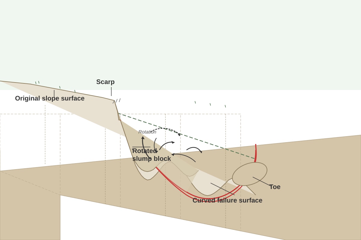
Answer: The mass movement shown is a slump (rotational slide). [1]
Slump involves the rotational movement of a mass of material along a curved, concave failure surface. The material rotates backwards as it moves downslope. [1]
Teaching Note: Slump is a type of mass movement where the failure surface is curved (concave), causing the moving material to rotate backwards. This distinguishes it from translational slides (planar failure surface) and flows (fluid-like movement).
Marking Note: 1 mark for correct identification, 1 mark for describing rotational movement along a curved surface.
17. [2 marks]
Answer:
- Deforestation/removal of vegetation (reduces root binding and increases water infiltration)
- Road construction/cutting into slopes (undercuts the slope and removes support)
- Building construction on slopes (adds weight and increases loading)
- Agricultural practices (e.g., over-irrigation increases pore water pressure)
Teaching Note: Human activities can increase mass movement risk by: (1) removing vegetation that binds soil, (2) altering slope geometry, (3) adding weight to slopes, (4) increasing water content in the soil.
Marking Note: 1 mark for each valid factor. Accept any two of the above or other well-explained factors.
18. [3 marks]
Answer: Splash erosion occurs when raindrops hit the bare soil surface with high kinetic energy. [1]
The impact of the raindrop detaches soil particles from the surface and splashes them into the air. [1]
On tropical hillslopes, the splashed particles are moved downslope by gravity, contributing to soil loss. This process is particularly significant in areas with high-intensity tropical rainfall and where vegetation cover has been removed. [1]
Teaching Note: Splash erosion is the first stage of water erosion. It detaches particles that can then be transported by surface runoff (rill wash, sheet wash). In the tropics, high-intensity rainfall means raindrops have greater kinetic energy, making splash erosion a significant process.
Marking Note: Award marks for: (1) raindrop impact/kinetic energy, (2) detachment of soil particles, (3) downslope movement and significance on tropical slopes.
19. [2 marks]
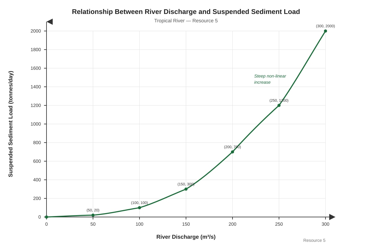
Answer: There is a positive, non-linear relationship between river discharge and suspended sediment load. [1]
As discharge increases, suspended sediment load increases at a disproportionately faster rate (the relationship is exponential or power-law). For example, when discharge doubles from 100 to 200 m³/s, sediment load increases from 100 to 700 tonnes/day. [1]
Teaching Note: The non-linear relationship exists because higher discharge has greater erosive power and can transport larger particles. Additionally, higher flows may trigger bank erosion and mass movement, supplying more sediment to the river.
Marking Note: 1 mark for identifying the positive/non-linear relationship, 1 mark for describing the disproportionate increase with reference to data.
20. [8 marks]
Answer:
Level 1 (1–3 marks): Describes either natural processes or human activities in isolation. Limited evaluation. May list processes without linking to landform formation.
Level 2 (4–6 marks): Explains both natural processes and human activities. Some attempt at evaluation, but may be unbalanced or lack specific examples.
Level 3 (7–8 marks): Comprehensive evaluation with balanced discussion of both natural and human factors. Uses specific examples of tropical landforms. Reaches a well-supported conclusion.
Suggested content:
Natural processes (dominant in most cases):
- Chemical weathering (carbonation, hydrolysis) is the primary process forming karst landscapes (limestone pavements, caves, sinkholes)
- Physical weathering (pressure release, thermal weathering) contributes to granite landforms (tors, exfoliation domes)
- Fluvial processes (corrasion, corrosion, hydraulic action) shape river valleys and gorges
- Mass movement (slides, flows) shapes hillslopes in tectonically active areas
- These processes operate over geological timescales (thousands to millions of years)
Human activities (increasingly significant):
- Deforestation accelerates soil erosion and mass movement, modifying slope morphology
- Urbanisation alters drainage patterns and increases runoff, affecting river channel form
- Mining and quarrying directly reshape landforms (e.g., limestone quarrying)
- Agriculture (terracing, irrigation) modifies hillslope form and soil development
- Climate change (human-induced) may alter rates of weathering and erosion
Evaluation points:
- For most tropical landforms (karst, river valleys, coastal features), natural processes are the primary formative agents
- Human activities tend to modify or accelerate natural processes rather than create entirely new landforms
- The relative importance varies by landform type and location
- In some cases (e.g., quarrying, urban landscapes), human activity is the dominant agent
- Timescale is important: natural processes operate over long periods, while human impacts are more recent and rapid
Conclusion: While human activities increasingly influence tropical landscapes, natural geomorphic processes remain the primary agents of landform formation. Human activities typically accelerate or modify existing processes rather than creating fundamentally new landforms.
Teaching Note: This is an evaluative essay requiring students to weigh the relative importance of natural processes versus human activities. Strong answers will use specific examples of tropical landforms and avoid one-sided arguments.
Marking Note: Use level descriptors as shown. Award marks based on:
- Knowledge of geomorphic processes (AO1) – 2 marks
- Analysis of both natural and human factors (AO2) – 3 marks
- Evaluation and conclusion (AO3) – 3 marks
--- End of Answer Key ---