AI Generated Quiz
A Level H1 Geography Human Geography Quiz
Free A Level H1 Geography Human Geography quiz, AI version, with questions, answers, and A Level-style practice for Singapore students.
These static practice materials are generated from the site's syllabus and paper-generation workflow, with source and model context shown so students and parents can evaluate the material before use.
Questions
Free quiz and exam paper access
Enter your details to view this paper
Your access is remembered on this device.
Answers
A-Level Geography H1 Quiz - Human Geography: Answer Key
Total Marks: 50
Section A: Fieldwork in Human Geography (12 marks)
Question 1 (1 mark)
- Answer: Students must obtain informed consent from the elderly participants, explaining the purpose of the survey and how their data will be used.
- Explanation: Ethical fieldwork requires that participants are fully aware they are part of a study and understand what they are agreeing to. Elderly residents may be more vulnerable than younger adults, so gaining their genuine voluntary consent is crucial. Other ethical considerations include maintaining confidentiality, avoiding causing distress, and ensuring the respondent can withdraw at any time.
- Marking Note: Award 1 mark for a clear, specific ethical consideration (e.g., informed consent, confidentiality, anonymity, right to withdraw).
Question 2 (2 marks — 1 mark each for two valid reasons)
- Answer: a) Face-to-face questionnaires allow for clarification of questions, which is particularly important for elderly respondents who may have hearing or vision difficulties. b) They can achieve a higher response rate than other methods (e.g., online or postal surveys), as the researcher can engage the participant directly.
- Explanation: The elderly may struggle with written or online surveys. An interviewer can read the questions aloud and explain any confusing terms. This method also helps build trust, which can increase the likelihood of obtaining honest, complete answers. Face-to-face interaction also allows the researcher to observe the respondent’s surroundings and non-verbal cues, enriching the data.
- Marking Notes:
- Do not award marks for generic reasons that apply to any survey (e.g., "it is easy") without a specific link to the elderly context.
- Accept: "reduces non-response due to language barriers," "allows observation of the built environment," "overcomes mobility issues for elderly who don't go online."
Question 3 (2 marks — 1 mark each for two valid risks)
- Answer: a) Unpredictable weather — extreme heat or sudden tropical rainstorms could harm the students while walking outside. b) Traffic hazards — urban streets may have heavy traffic, and students could be at risk of accidents while moving between survey locations.
- Explanation: Fieldwork in an urban setting involves physical risks. In Singapore's tropical climate, heat exhaustion and dehydration are common risks, especially for students carrying equipment and walking for long periods. Rain also creates slippery surfaces and increases the risk of falling. Other risks include encountering stray animals (e.g., monkeys or dogs), getting lost, or interacting with uncooperative members of the public.
- Marking Notes:
- Accept also: "tripping hazards from uneven pavements," "dealing with strangers who refuse or are aggressive," "sunburn/heat stress," "theft of valuables," "road traffic accidents."
- Do not accept generic answers like "making mistakes" — the risk must be a physical or safety hazard.
Question 4 (2 marks)
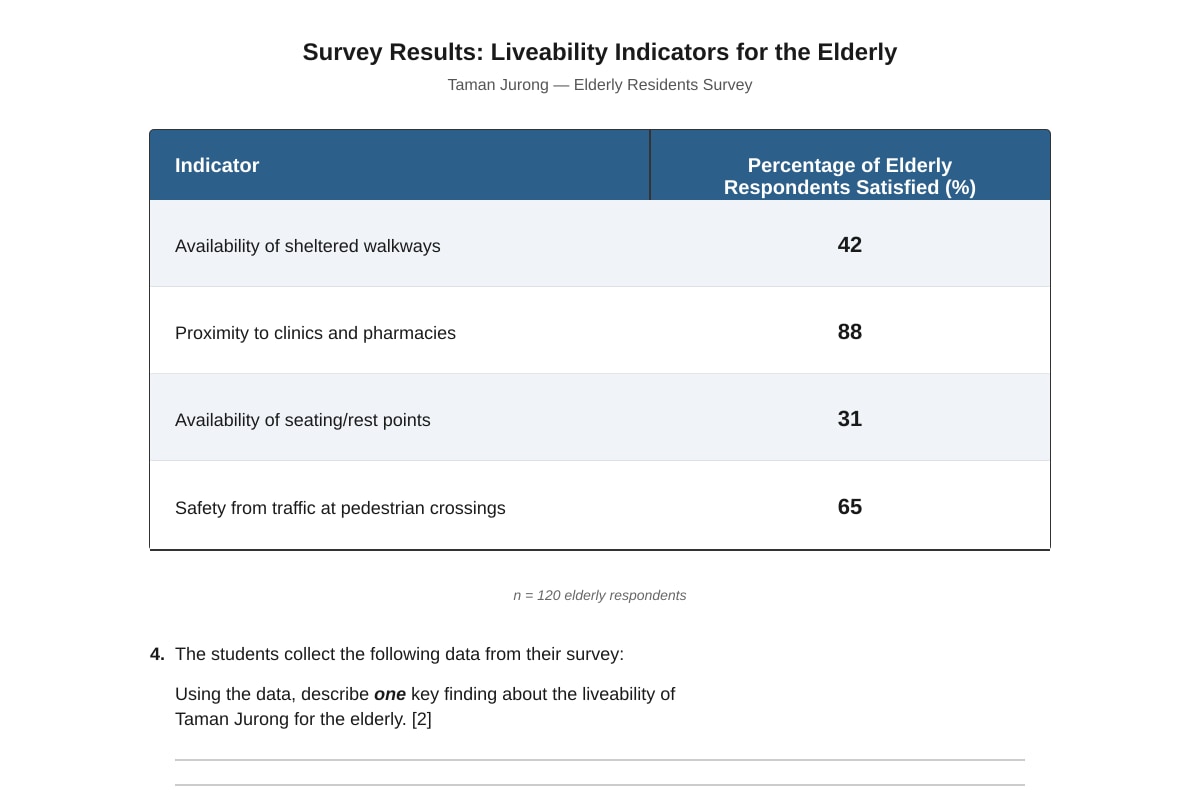
- Answer: A key finding is that only 31% of elderly respondents were satisfied with the availability of seating/rest points, indicating a significant gap in the provision of rest facilities along walkways. (Also accept: "88% were satisfied with proximity to clinics/pharmacies, suggesting this aspect of liveability is good.")
- Explanation: The table provides percentages for four different aspects of liveability. A "key finding" is a significant observation that answers the research question. Identifying the lowest or highest percentage is a valid way to isolate a key finding. The mark is for stating the finding (1 mark) and linking it to the indicator (1 mark).
- Marking Notes: Award 1 mark for correctly identifying a significant result (e.g., "seating has the lowest satisfaction") and 1 mark for referencing the specific percentage or providing a brief interpretation ("this is a low level of liveability").
Question 5 (5 marks)
- Answer:
- Limitation 1: Lack of depth/context (2 marks): Quantitative data shows what people think (e.g., 88% are satisfied with clinic proximity) but not why they think it. An elderly resident might be satisfied with the distance to the clinic but unhappy with the cost of treatment, or the difficulty of the walk if they are using a walking aid. This lack of context limits the usefulness of the data for designing targeted interventions.
- Limitation 2: Missing emotional/personal experience (2 marks): Numbers cannot capture feelings of loneliness, fear of crime, or a sense of community belonging. A quantitative score on "safety" might be high, but it does not reveal whether the respondent feels safe during the day but not at night, or whether they avoid certain spots due to bad memories. The subjective experience of liveability is lost.
- Overall evaluation (1 mark): Therefore, while quantitative data provides a broad overview, it should be supplemented with qualitative methods (e.g., semi-structured interviews, walking tours) to fully understand the lived experience of the elderly.
- Explanation: This is an evaluation question requiring both identification of a limitation AND an explanation of WHY it is a limitation. The 5-mark allocation suggests 2 marks for each well-explained limitation and 1 mark for a concluding judgment that links back to the fieldwork context. Keywords from the syllabus: "subjective nature of liveability."
- Marking Scheme:
- L1 (1–2 marks): Identifies a generic limitation (e.g., "numbers don't tell the whole story") with weak explanation.
- L2 (3–4 marks): Identifies TWO limitations with clear explanation tied to the elderly context.
- L3 (5 marks): L2 + a clear evaluative judgment about the overall usefulness of the data.
- Common Mistakes: Simply listing limitations without explaining them. Forgetting to link the point to the specific topic of liveability for the elderly.
Section B: Challenges of Liveable and Sustainable Cities (20 marks)
Question 6 (1 mark)
- Answer: Liveability refers to the quality of life in a city as experienced by its residents, often measured by factors such as safety, healthcare, economic opportunity, housing, and environmental quality.
- Explanation: "Liveability" is a core concept in urban geography. It is subjective (it depends on who is assessing it and for what purpose) and multi-dimensional (it includes economic, social, and environmental factors). A one-mark question expects a concise definition that captures the essence of the term.
- Marking Note: Award 1 mark for a clear definition that mentions "quality of life," "well-being," or the "experience of residents."
Question 7 (2 marks — 1 mark each)
- Answer: a) Adequate street lighting to improve personal safety when walking at night. b) Availability of public toilets and nursing rooms to accommodate women's different needs.
- Explanation: The syllabus explicitly covers "Liveable Cities for Women." Common indicators relevant to women's needs include safety from harassment (lighting, CCTV), access to childcare facilities, public transport coverage, and inclusive public spaces. Gender-sensitive indicators recognize that women's daily routines and safety concerns often differ from men's.
- Marking Notes: Accept any two indicators that relate to safety, accessibility, economic participation, or social well-being of women specifically. Do not accept generic indicators like "good schools" unless linked to a women-specific need.
Question 8 (2 marks)
- Answer: Slums are often located in hazardous areas (e.g., floodplains, near waste dumps) and lack basic services like clean water, sewerage, and electricity. This degrades the local environment, creates public health risks, and perpetuates a cycle of poverty and deprivation, directly undermining the social and environmental pillars of sustainable development.
- Explanation: The question asks for ONE reason. The mark scheme: 1 mark for identifying a specific impact on sustainability (e.g., environmental pollution, public health crisis, social inequality), and 1 mark for explaining the link to "sustainable urban development." "Sustainable development" often requires balancing economic growth, social equity, and environmental protection. Slums typically undermine all three.
- Marking Notes: A good answer links specific deprivations (lack of sanitation) to a sustainability concept (e.g., "pollution of waterways" → environmental unsustainability). A vague answer like "slums are bad for development" scores 0.
Question 9 (2 marks — 1 mark each)
- Answer: a) Leachate contamination — rainwater percolating through open dumps creates toxic liquid that can pollute groundwater and soil. b) Air pollution from open burning — waste is often burned in the open, releasing harmful fumes (e.g., dioxins, particulate matter) into the atmosphere.
- Explanation: Non-hazardous solid waste (household garbage) in developing countries is often dumped in unregulated sites. The two biggest environmental problems are water and air pollution. Other answers include: "breeding of disease vectors (e.g., rats, mosquitoes)," "greenhouse gas emissions (methane from decomposing waste)," "land degradation."
- Marking Notes: Each answer must be an environmental challenge (not just a social or economic one). The challenge must be specific — "pollution" alone is not enough; specify what type of pollution (air, water, soil).
Question 10 (4 marks — 2 marks for each well-developed reason)
- Answer: a) Rapid rural-to-urban migration outpaces housing supply (2 marks): People move to cities seeking jobs, but the formal housing sector cannot build enough affordable homes fast enough. As a result, new arrivals are forced to occupy any available land, leading to the spontaneous growth of slums. b) Weak governance and lack of land-use planning (2 marks): Many developing country governments lack the financial resources, technical capacity, or political will to enforce building codes, provide serviced land, or prevent squatting. In contrast, developed countries typically have stronger institutions that enforce regulations and provide public housing or subsidies.
- Explanation: The question expects a comparative answer. Each reason should contrast the situation in a developing country with a developed country context. "Push" factors driving slum growth include: rapid urbanization, weak governance, lack of affordable housing, insecure land tenure, income inequality, and limited urban planning.
- Marking Scheme:
- Each well-developed reason = 2 marks (1 mark for identification + 1 mark for explanation/showing contrast).
- A reason without comparison/contrast = 1 mark max.
- A reason that is merely descriptive (e.g., "there are many people") = 0 marks.
Question 11 (2 marks — 1 mark each)
- Answer: a) Relocating squatters, farmers, and industries away from the river. b) Constructing a riverside promenade and new commercial buildings (e.g., restaurants, bars, condominiums).
- Explanation: This is a straightforward extract-based question. The text explicitly lists these actions. A good answer paraphrases the source rather than copying it verbatim. The examiner is testing the ability to identify specific examples of a strategy.
- Marking Notes: Each correct, specific strategy from the source = 1 mark. Generic answers like "they made it look nicer" = 0.
Question 12 (4 marks — 2 marks for each reason)
- Answer: a) To attract foreign investment and boost tourism (2 marks): Transforming the Singapore River and Marina Bay into clean, aesthetically pleasing, commercial spaces makes Singapore more attractive to multinational corporations and tourists. This generates revenue, creates jobs in the service and hospitality sectors, and enhances the city's global brand. b) To revitalize the local economy and increase land value (2 marks): By cleaning up a polluted waterway and developing a new waterfront district, the government increased the economic value of the land. High-end condominiums, offices, and hotels on the reclaimed land generate significant tax revenue and economic activity, making the project self-sustaining in the long run.
- Explanation: "Economic reasons" means the goals are related to money, growth, and prosperity. The source mentions: "global financial hub," "tourist destination," and "commercial buildings." Students should link these to concepts like economic diversification, competitiveness, and land value uplift.
- Marking Scheme: 1 mark for identifying the reason + 1 mark for explaining the economic logic. Award up to 4 marks for two well-explained reasons.
Question 13 (5 marks)
- Answer:
- Positive contribution (2 marks): Urban reimaging contributes to sustainable development by cleaning up polluted environments (e.g., cleaning the Singapore River), creating green spaces (e.g., Gardens by the Bay), and promoting economic growth. A cleaner river improves environmental health and provides recreational opportunities for residents, which is economically and socially sustainable.
- Negative social impact (2 marks): However, such projects can lead to gentrification and displacement. The relocation of squatters and industries from the Singapore River displaced low-income communities who could not afford to move back to the newly upscale area. This erodes social sustainability by removing affordable housing and breaking up established communities, forcing people to less accessible areas.
- Evaluation (1 mark): Therefore, while urban reimaging can enhance environmental and economic sustainability, its contribution to overall sustainable development is limited if it excludes lower-income groups. A truly sustainable project must actively include affordable housing and community benefits within its plan.
- Explanation: This is an evaluative "To what extent?" question. A good answer must demonstrate both sides of the argument (positive contribution AND limitation) and reach a balanced conclusion. The specific instruction to "suggest one potential negative social impact" is a requirement; omitting it loses marks.
- Marking Scheme (based on AO2/AO3):
- L1 (1–2 marks): States a simple point about reimaging being good or bad.
- L2 (3–4 marks): Explains both positive and negative aspects with reference to the source/concept.
- L3 (5 marks): L2 + a clear evaluative statement about the balance.
Section C: Climate Change and Human Vulnerability (18 marks)
Question 14 (1 mark)
- Answer: Evidence from ice cores (e.g., from Antarctica/Greenland) showing changes in atmospheric carbon dioxide and temperature over hundreds of thousands of years.
- Explanation: Proxy indicators like ice cores, ocean sediment cores, and tree rings provide data on climate before modern thermometers. The syllabus specifically mentions "proxy indicators" as a key piece of evidence for past climate variability.
- Marking Notes: Award 1 mark for a specific proxy indicator (ice cores, ocean cores, tree rings, fossil pollen, etc.). "Fossils" is acceptable if specified. "History books" or "old weather records" is not considered a proxy indicator.
Question 15 (2 marks)
- Answer: A positive feedback amplifies the initial change, making the system move further away from its original state (e.g., melting ice reduces albedo → more heat absorbed → more melting). A negative feedback dampens the initial change, stabilizing the system (e.g., increased CO₂ → more plant growth → more carbon absorbed from the atmosphere).
- Explanation: The distinction is one of direction. Both are "loops" where an output becomes an input. Positive feedback accelerates a process; negative feedback stabilizes a process. In climate change, the main concern is the dominance of positive feedbacks (e.g., ice-albedo feedback, permafrost thaw releasing methane).
- Marking Scheme: 1 mark for correctly defining/describing positive feedback, 1 mark for negative feedback. Or, 2 marks for a clear head-to-head contrast. A simple one-word definition without context (e.g., "positive feedback makes things worse") = 1 mark max.
Question 16 (4 marks — 2 marks each)
- Answer: a) Increased atmospheric CO₂ from burning fossil fuels (2 marks): When coal, oil, and gas are burned for energy, they release stored carbon as CO₂. This atmospheric CO₂ traps outgoing longwave (infrared) radiation from the Earth's surface that would otherwise escape to space. This enhanced absorption of heat by the atmosphere causes global average temperatures to rise. b) Reduction of carbon sinks through deforestation (2 marks): Forests act as a carbon sink by absorbing CO₂ during photosynthesis. When forests are cleared for agriculture or urban development, this absorption capacity is reduced. In addition, if the cleared biomass is burned, the stored carbon is released directly into the atmosphere, further contributing to the greenhouse effect.
- Explanation: The question asks for TWO ways. Each way must link a specific human activity to the mechanism of the enhanced greenhouse effect. The key mechanism is that anthropogenic greenhouse gases increase the atmosphere's ability to absorb and re-radiate infrared radiation, trapping more heat. The two major human activities driving this are emissions (sources) and sink reduction.
- Marking Notes:
- 1 mark for identifying the human activity + 1 mark for explaining the climatic mechanism.
- Accept other activities: "agriculture (methane from livestock/cattle)," "cement production (CO₂)," "industrial processes (fluorinated gases)."
- Do not award marks for activity-only statements without explaining the "greenhouse" connection.
Question 17 (2 marks — 1 mark each)
- Answer: a) Sea-level rise. b) Saltwater intrusion into freshwater aquifers. (Also accept: "more intense tropical cyclones.")
- Explanation: This is a direct extraction question from the source material. The source lists three risks: sea-level rise, saltwater intrusion, and more intense tropical cyclones. The student must identify any two.
- Marking Notes: Each correct risk = 1 mark. Paraphrasing is acceptable as long as the meaning is clear. The risk must be specific to the climate category.
Question 18 (2 marks)
- Answer: Low-income residents in informal settlements tend to live in hazardous locations (e.g., riverbanks, floodplains, steep slopes) because they are the only affordable places available. These locations are highly exposed to floods and landslides that are becoming more frequent with climate change. Wealthier residents can afford to live in safer, well-drained, higher-elevation areas with flood protection infrastructure.
- Explanation: The key concept is "differential vulnerability." Vulnerability is a function of both exposure to a hazard and the capacity to cope. Poorer residents are more exposed (due to land markets pushing them to marginal land) AND have less capacity to cope (no insurance, fewer savings, less political power to demand adaptation).
- Marking Scheme: 1 mark for identifying an exposure/capacity factor + 1 mark for explaining the link to higher vulnerability. A simple statement like "they are poor" gets 0 marks unless explained in a climate change context.
Question 19 (2 marks)
- Answer: Increased sea surface temperature could lead to coral bleaching in the region's marine ecosystems (e.g., coral reefs around Indonesia and the Philippines). A sustained temperature increase of only 1-2°C for a few weeks can cause corals to expel the symbiotic algae (zooxanthellae) living in their tissues, turning them white and potentially killing them.
- Explanation: The question connects "changes in temperature and precipitation" to "aquatic ecosystems." The most prominent impact for Southeast Asia's aquatic ecosystems is the threat to coral reefs from rising sea temperatures. Another valid answer is: "changes in freshwater flow due to altered rainfall patterns, affecting fish migration and spawning in rivers and estuaries."
- Marking Notes: 1 mark for identifying a specific impact (e.g., coral bleaching, altered species distribution, changes in nutrient supply) + 1 mark for explaining the mechanism linking climate change to the ecosystem change.
Question 20 (5 marks)
- Answer:
- Urgency in developing countries (2 marks): Developing countries like Bangladesh (Dhaka), Indonesia (Jakarta), and Vietnam (Ho Chi Minh City) face existential threats from sea-level rise. The source mentions these cities are low-lying and contain large low-income populations. Adaptation (e.g., building seawalls, raising roads, improving drainage) is urgent here because their geography and high population density mean any delay will lead to catastrophic loss of life and economic damage.
- Higher capacity in developed countries (2 marks): The source shows European countries investing in expensive, large-scale infrastructure (e.g., Maeslantkering, Thames Barrier). These are possible because of higher GDP, strong institutions, and advanced engineering. While adaptation is also needed in developed countries, the urgency is lower because they face fewer immediate, life-threatening impacts relative to South and Southeast Asia.
- Discussion (1 mark): Therefore, adaptation is more urgent in developing countries because their vulnerability is much higher and their adaptive capacity is much lower. Without urgent adaptation, the sustainable development goals in these regions will be severely undermined.
- Explanation: This is a "Discuss" question, requiring a reasoned argument. The answer must compare/contrast developing and developed countries using examples from the source. Key concepts: vulnerability (exposure + sensitivity + adaptive capacity), urgency (immediacy of human impact).
- Marking Scheme (Adapted AO3):
- L1 (1–2 marks): Simple statement that developing countries are more at risk.
- L2 (3–4 marks): Develops ONE side of the argument with source evidence, or describes both sides without evaluation.
- L3 (5 marks): Balanced discussion that compares urgency and draws a reasoned conclusion supported by specific examples.
END OF ANSWER KEY