From Real Exams Exam Paper
A Level H1 Geography Practice Paper 3
Free A Level H1 Geography Practice Paper 3, DeepSeek Exam version, with questions, answers, and A Level-style practice for Singapore students.
These static practice materials are generated from the site's syllabus and paper-generation workflow, with source and model context shown so students and parents can evaluate the material before use.
Questions
TuitionGoWhere Practice Paper – Geography H1 A-Level
TuitionGoWhere Exam Practice (AI)
| Field | Detail |
|---|---|
| Subject: | Geography H1 (8834) |
| Level: | A-Level |
| Paper: | PRACTICE – Theme: Resources & Sustainability |
| Version: | 3 of 5 |
| Duration: | 1 hour 30 minutes |
| Total Marks: | 60 |
Name: _________________________ Class: _________________________ Date: _________________________
Instructions to Candidates
- This paper consists of two sections: Section A and Section B.
- Answer all questions in Section A.
- Answer one question from Section B.
- Write your answers in the spaces provided.
- Marks are indicated in brackets [ ] at the end of each question or part question.
- You are advised to spend approximately 45 minutes on Section A and 45 minutes on Section B.
- Support your answers with relevant examples and evidence where appropriate.
Section A: Data Response Questions [40 marks]
Answer all questions in this section.
Question 1: Urban Liveability in Singapore [20 marks]
Study Resources 1A, 1B, and 1C, then answer the questions that follow.
Resource 1A: Liveability Indicators for Selected Singapore Neighbourhoods (2024)
| Neighbourhood | Green Space per capita (m²) | Access to Public Transport (%) | Air Quality Index (PSI) | Resident Satisfaction Score (out of 10) |
|---|---|---|---|---|
| Taman Jurong | 8.2 | 92 | 45 | 7.1 |
| Ang Mo Kio | 12.5 | 88 | 42 | 7.8 |
| Punggol | 15.8 | 78 | 38 | 8.2 |
| Bukit Merah | 6.4 | 95 | 48 | 6.5 |
| Queenstown | 10.1 | 90 | 40 | 7.9 |
Resource 1B: Photograph of Taman Jurong Neighbourhood (2024)
[Photograph shows a high-density HDB estate with a mix of older and newer blocks. A small community garden is visible in the foreground. Several elderly residents are seen sitting at void deck benches. A covered walkway connects blocks to a nearby bus stop. Some blocks show visible façade wear.]
Resource 1C: Extract from Urban Redevelopment Authority (URA) Report on Liveability Interventions
"The Remaking Our Heartland (ROH) programme has channelled significant investment into mature estates. In Taman Jurong, recent interventions include the upgrading of neighbourhood parks, installation of elderly-friendly fitness corners, and enhancement of sheltered connectivity. However, challenges remain in retrofitting older blocks with modern amenities and addressing the needs of an ageing population. Community feedback indicates strong demand for more healthcare facilities and barrier-free access routes."
(a) With reference to Resource 1A, describe the relationship between green space per capita and resident satisfaction scores across the five neighbourhoods. [4 marks]
(b) Explain two characteristics of the Taman Jurong neighbourhood as seen in Resource 1B. [5 marks]
(c) With reference to Resources 1A and 1C, account for the resident satisfaction score in Taman Jurong. [5 marks]
(d) Evaluate the usefulness of Resources 1B and 1C in helping to understand the challenges of improving urban liveability for elderly residents in Singapore. [6 marks]
Question 2: Tropical Cyclones and Flooding [20 marks]
Study Resources 2A, 2B, and 2C, then answer the questions that follow.
Resource 2A: Spatial Distribution of Tropical Cyclones Affecting Southeast Asia (2000–2023)
| Country | Number of Cyclone Landfalls | Most Affected Region | Peak Month |
|---|---|---|---|
| Philippines | 87 | Eastern Visayas | November |
| Vietnam | 42 | Central Coast | October |
| Myanmar | 18 | Ayeyarwady Delta | May |
| Thailand | 12 | Southern Peninsula | November |
| Malaysia | 5 | East Coast (Sabah) | December |
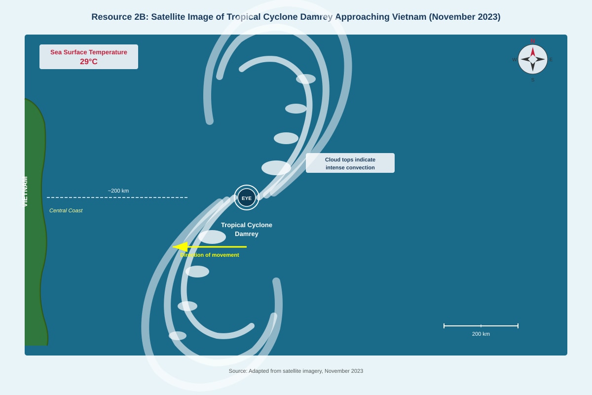
Resource 2B: Satellite Image of Tropical Cyclone Damrey Approaching Vietnam (November 2023)
Generated image for this question.
Resource 2C: Flood Hydrograph for the Thu Bon River, Central Vietnam (November 2023)
| Time (hours after storm landfall) | 0 | 6 | 12 | 18 | 24 | 30 | 36 | 42 | 48 |
|---|---|---|---|---|---|---|---|---|---|
| Discharge (m³/s) | 120 | 180 | 420 | 890 | 1,250 | 980 | 620 | 380 | 210 |
| Rainfall intensity (mm/hr) | 0 | 5 | 18 | 32 | 28 | 12 | 4 | 0 | 0 |
(a) Describe the spatial distribution of tropical cyclone landfalls in Southeast Asia as shown in Resource 2A. [4 marks]
(b) With reference to Resource 2B, explain two conditions that contributed to the development of Tropical Cyclone Damrey. [5 marks]
(c) Using Resource 2C, describe and explain the relationship between rainfall intensity and river discharge during the storm event. [5 marks]
(d) "Accurate flood forecasting is the most effective strategy for reducing the impacts of tropical cyclone-induced flooding in Southeast Asia." Evaluate this statement with reference to Resources 2A–2C and your own knowledge. [6 marks]
Section B: Essay Questions [20 marks]
Answer one question from this section. Your essay should be approximately 600–800 words. Credit will be given for the use of relevant case studies and examples.
Question 3
"Slums are the greatest impediment confronting cities in achieving sustainable urban development." How far do you agree with this statement? Support your answer with specific case studies. [20 marks]
Question 4
"Climate change can only be mitigated with the collective effort of nations." To what extent do you agree with this statement? Support your answer with relevant examples. [20 marks]
— End of Paper —
Answers
TuitionGoWhere Practice Paper – Geography H1 A-Level
Answer Key and Marking Scheme
Paper: PRACTICE – Theme: Resources & Sustainability Version: 3 of 5 Total Marks: 60
Section A: Data Response Questions [40 marks]
Question 1: Urban Liveability in Singapore [20 marks]
(a) With reference to Resource 1A, describe the relationship between green space per capita and resident satisfaction scores across the five neighbourhoods. [4 marks]
Answer/Marking Notes:
Award 1 mark for each valid point supported by data from the table:
-
Positive correlation identified: There is a general positive relationship between green space per capita and resident satisfaction scores. Neighbourhoods with higher green space tend to have higher satisfaction scores. [1 mark]
-
Evidence – high green space/high satisfaction: Punggol has the highest green space (15.8 m² per capita) and the highest satisfaction score (8.2). Queenstown (10.1 m²) and Ang Mo Kio (12.5 m²) also show relatively high satisfaction (7.9 and 7.8 respectively). [1 mark]
-
Evidence – low green space/low satisfaction: Bukit Merah has the lowest green space (6.4 m² per capita) and the lowest satisfaction score (6.5). Taman Jurong (8.2 m²) also shows a lower satisfaction score (7.1). [1 mark]
-
Nuance/exception noted: The relationship is not perfectly linear. For example, Ang Mo Kio has higher green space (12.5 m²) than Queenstown (10.1 m²) but a slightly lower satisfaction score (7.8 vs. 7.9), suggesting other factors also influence satisfaction. [1 mark]
Accept any other valid observations supported by data.
(b) Explain two characteristics of the Taman Jurong neighbourhood as seen in Resource 1B. [5 marks]
Answer/Marking Notes:
Award marks for identifying a characteristic (1 mark each) and providing an explanation (1–1.5 marks each), up to 5 marks total.
Characteristic 1: High-density housing with ageing infrastructure
- Identification: The photograph shows a high-density HDB estate with a mix of older and newer blocks. Some blocks display visible façade wear. [1 mark]
- Explanation: This indicates that Taman Jurong is a mature estate, built several decades ago. The visible wear suggests that maintenance and upgrading are ongoing challenges. Older blocks may lack modern amenities and require retrofitting to meet current liveability standards. [1.5 marks]
Characteristic 2: Presence of elderly population with some age-friendly features
- Identification: Several elderly residents are visible sitting at void deck benches. A small community garden and covered walkway connecting to a bus stop are also present. [1 mark]
- Explanation: The presence of elderly residents suggests an ageing population profile in the neighbourhood. The covered walkway and community garden represent efforts to improve liveability for seniors by providing shelter, recreational space, and connectivity. However, the limited scale of these features may indicate that more comprehensive elderly-friendly infrastructure is needed. [1.5 marks]
Accept other valid characteristics such as: limited green space, reliance on bus transport, community-oriented design. Award partial marks for identification without explanation.
(c) With reference to Resources 1A and 1C, account for the resident satisfaction score in Taman Jurong. [5 marks]
Answer/Marking Notes:
Award marks for explaining factors that contribute to the satisfaction score (7.1/10), using evidence from both resources.
-
Positive factors from Resource 1C (ROH programme): The Remaking Our Heartland programme has invested in Taman Jurong, including upgrading neighbourhood parks, installing elderly-friendly fitness corners, and enhancing sheltered connectivity. These interventions likely contribute positively to resident satisfaction by improving amenities and accessibility. [1.5 marks]
-
Limiting factors from Resource 1A: Taman Jurong has relatively low green space per capita (8.2 m²) compared to Punggol (15.8 m²) and Ang Mo Kio (12.5 m²). This may constrain satisfaction, as green space is associated with higher liveability. However, the high access to public transport (92%) is a positive factor. [1.5 marks]
-
Challenges from Resource 1C: The extract notes challenges in retrofitting older blocks and addressing the needs of an ageing population. Community feedback indicates strong demand for more healthcare facilities and barrier-free access routes. These unmet needs likely suppress the satisfaction score, explaining why it remains moderate (7.1) despite ROH interventions. [2 marks]
Accept any valid synthesis of evidence from both resources. Award partial marks for points using only one resource.
(d) Evaluate the usefulness of Resources 1B and 1C in helping to understand the challenges of improving urban liveability for elderly residents in Singapore. [6 marks]
Answer/Marking Notes:
Award marks for a balanced evaluation addressing both strengths and limitations of each resource, with an overall judgment.
Resource 1B (Photograph) – Strengths:
- Provides visual evidence of the physical environment elderly residents experience daily (void decks, covered walkways, community garden). [1 mark]
- Shows actual elderly presence, confirming the demographic relevance of the liveability challenge. [0.5 mark]
- Captures both positive features (connectivity) and limitations (façade wear, limited facilities) in a single view. [0.5 mark]
Resource 1B – Limitations:
- A single photograph represents only one moment and location; it cannot show the full range of conditions across the neighbourhood. [0.5 mark]
- Cannot convey resident experiences, satisfaction levels, or specific needs—only visible physical conditions. [0.5 mark]
- Does not show healthcare facilities, barrier-free access routes, or other features specifically relevant to elderly liveability. [0.5 mark]
Resource 1C (URA Report Extract) – Strengths:
- Provides authoritative, policy-level information on specific interventions (ROH programme) and their intended outcomes. [1 mark]
- Identifies specific challenges (retrofitting, ageing population needs, healthcare demand) that directly relate to elderly liveability. [0.5 mark]
- Includes community feedback, offering insight into resident perspectives beyond physical observations. [0.5 mark]
Resource 1C – Limitations:
- The extract is brief and may not capture the full scope of URA's assessment or all neighbourhood-specific issues. [0.5 mark]
- As a government publication, it may present an optimistic view of interventions and understate challenges. [0.5 mark]
Overall Judgment:
- Together, the resources are moderately useful. Resource 1C provides policy context and identifies specific elderly-related challenges, while Resource 1B offers visual grounding. However, neither resource provides quantitative data on elderly satisfaction, detailed mapping of barrier-free access, or comparison with other neighbourhoods. Additional resources such as resident surveys, healthcare accessibility maps, or longitudinal data on ROH outcomes would strengthen understanding. [1 mark]
Award up to 6 marks for a well-structured evaluation with explicit strengths, limitations, and a concluding judgment. Accept alternative valid evaluations.
Question 2: Tropical Cyclones and Flooding [20 marks]
(a) Describe the spatial distribution of tropical cyclone landfalls in Southeast Asia as shown in Resource 2A. [4 marks]
Answer/Marking Notes:
Award 1 mark for each valid spatial description supported by data:
-
Concentration in the Philippines: The Philippines experiences the highest number of cyclone landfalls (87), far exceeding all other Southeast Asian countries. This indicates a strong spatial concentration in the western North Pacific basin. [1 mark]
-
East-facing coastlines most affected: Countries with east-facing coastlines (Philippines – Eastern Visayas; Vietnam – Central Coast; Malaysia – East Coast Sabah) are the most affected regions within each country, suggesting cyclones approach from the Pacific Ocean and South China Sea. [1 mark]
-
Decreasing frequency westward and southward: The number of landfalls decreases significantly from the Philippines (87) to Vietnam (42), Myanmar (18), Thailand (12), and Malaysia (5). This reflects the typical westward track of tropical cyclones, which weaken as they move over land or cooler waters. [1 mark]
-
Latitudinal pattern: The most affected regions are located between approximately 5°N and 20°N, consistent with the tropical cyclone belt where Coriolis force is sufficient for cyclone formation and warm sea surface temperatures prevail. [1 mark]
Accept any other valid spatial descriptions with data support.
(b) With reference to Resource 2B, explain two conditions that contributed to the development of Tropical Cyclone Damrey. [5 marks]
Answer/Marking Notes:
Award marks for identifying a condition (1 mark each) and explaining its role in cyclone development (1.5 marks each), up to 5 marks.
Condition 1: High sea surface temperatures (SST)
- Identification: The satellite image annotation indicates sea surface temperatures of 29°C in the South China Sea. [1 mark]
- Explanation: Tropical cyclones require SST of at least 26.5°C to provide sufficient heat and moisture energy. At 29°C, the warm ocean water drives intense evaporation, providing abundant water vapour that rises, condenses, and releases latent heat. This latent heat fuels the storm's convection and intensification. The well-defined spiral cloud bands and distinct eye in the image indicate a mature, well-developed cyclone, consistent with the high energy supply from warm waters. [1.5 marks]
Condition 2: Low wind shear and organised convection
- Identification: The image shows a well-defined spiral cloud band with a distinct eye, indicating organised convection and low vertical wind shear. [1 mark]
- Explanation: Low wind shear allows the storm's vertical structure to remain intact, preventing the dispersal of heat and moisture at upper levels. The distinct eye indicates strong upward motion in the eyewall and sinking air in the centre, a hallmark of intense cyclones. The intense cloud tops suggest strong convection, which is sustained when upper-level winds do not disrupt the storm's circulation. [1.5 marks]
Accept other valid conditions such as: sufficient Coriolis force at the storm's latitude (~15°N), pre-existing low-pressure disturbance, or high relative humidity in the mid-troposphere. Award partial marks for identification without explanation.
(c) Using Resource 2C, describe and explain the relationship between rainfall intensity and river discharge during the storm event. [5 marks]
Answer/Marking Notes:
Award marks for describing the relationship (2 marks) and explaining it (3 marks).
Description of relationship:
- There is a clear positive correlation between rainfall intensity and river discharge, but with a time lag. Rainfall intensity peaks at 18 hours (32 mm/hr), while river discharge peaks later at 24 hours (1,250 m³/s). [1 mark]
- Both variables show a rapid rise and fall pattern characteristic of a flashy hydrograph. Discharge rises from a baseflow of 120 m³/s to a peak of 1,250 m³/s within 24 hours, then declines to 210 m³/s by 48 hours. [1 mark]
Explanation:
- The time lag (approximately 6 hours between peak rainfall and peak discharge) occurs because water takes time to travel through the drainage basin via surface runoff, throughflow, and channel flow to reach the gauging station. [1 mark]
- The rapid rise in discharge (steep rising limb) is explained by high rainfall intensity (32 mm/hr) exceeding the infiltration capacity of the soil, generating large volumes of surface runoff. The tropical cyclone's intense rainfall saturates the ground quickly, reducing infiltration and increasing overland flow. [1 mark]
- The rapid decline in discharge after the peak (steep recession limb) suggests limited groundwater storage in the basin, possibly due to impermeable geology or steep topography in the Thu Bon River catchment, which channels water quickly out of the system. [1 mark]
Accept alternative valid explanations referencing hydrological processes such as antecedent soil moisture, vegetation interception, or drainage basin characteristics.
(d) "Accurate flood forecasting is the most effective strategy for reducing the impacts of tropical cyclone-induced flooding in Southeast Asia." Evaluate this statement with reference to Resources 2A–2C and your own knowledge. [6 marks]
Answer/Marking Notes:
Award marks for a balanced evaluation that considers the effectiveness of flood forecasting alongside other strategies, using resource evidence and own knowledge.
Arguments supporting flood forecasting:
- Resource 2C demonstrates that rainfall and discharge data can reveal the timing and magnitude of flood peaks. Accurate forecasting using such hydrograph data allows authorities to issue timely warnings, enabling evacuation and preparation before floodwaters peak. [1 mark]
- Resource 2A shows that certain countries (e.g., Philippines with 87 landfalls) face recurrent cyclone threats. Forecasting systems tailored to these high-frequency areas can build institutional memory and community preparedness over time. [0.5 mark]
- Forecasting is cost-effective compared to structural measures; it requires meteorological and hydrological monitoring infrastructure rather than large-scale engineering works. Early warning systems have demonstrably reduced mortality in countries like Bangladesh and the Philippines. [0.5 mark]
Arguments challenging flood forecasting as the most effective strategy:
- Forecasting alone cannot reduce the physical vulnerability of communities. Resource 2A shows that countries like Myanmar (18 landfalls) and Vietnam (42 landfalls) may lack the infrastructure, communication networks, or institutional capacity to act on forecasts effectively. [1 mark]
- Structural measures (levees, flood walls, retention basins) and non-structural measures (land-use zoning, mangrove restoration, elevated housing) directly reduce exposure and vulnerability regardless of forecast accuracy. In Vietnam's Central Coast (Resource 2A), mangrove restoration has been shown to reduce storm surge impacts. [1 mark]
- Resource 2C shows a very rapid flood peak (within 24 hours). In such flashy catchments, even accurate forecasts may provide insufficient lead time for effective evacuation, especially in densely populated or remote areas. [0.5 mark]
- Long-term strategies such as climate adaptation planning, poverty reduction, and improved building codes address the root causes of vulnerability, which forecasting cannot. [0.5 mark]
Overall judgment:
- Accurate flood forecasting is a highly effective and essential component of flood risk management, particularly for saving lives through early warning. However, it is most effective when integrated with other strategies including structural defences, land-use planning, and community preparedness. In isolation, forecasting cannot address the physical and socio-economic vulnerabilities that turn a hazard into a disaster. Therefore, while forecasting is critically important, it is not singularly the "most effective" strategy. [1 mark]
Award up to 6 marks for a well-structured evaluation with explicit reference to resources, use of own knowledge, and a balanced concluding judgment.
Section B: Essay Questions [20 marks]
Question 3
"Slums are the greatest impediment confronting cities in achieving sustainable urban development." How far do you agree with this statement? Support your answer with specific case studies. [20 marks]
Marking Scheme and Response Framework:
| Level | Marks | Descriptor |
|---|---|---|
| L4 | 17–20 | Excellent evaluation with balanced arguments, specific case studies, clear definition of sustainability, and a well-supported conclusion. Demonstrates critical thinking about the role of slums relative to other impediments. |
| L3 | 13–16 | Good evaluation with relevant case studies and some balance. Addresses both sides of the argument but may lack depth in one area. Conclusion present but may be less developed. |
| L2 | 9–12 | Adequate response with some case study reference. May be largely descriptive or one-sided. Limited evaluation of "greatest impediment" claim. |
| L1 | 1–8 | Basic response with limited or no case studies. Descriptive rather than evaluative. May misunderstand key terms. |
Expected Content:
Introduction (2–3 marks' worth):
- Define key terms: slums (informal settlements characterised by inadequate housing, insecure tenure, and deficient services); sustainable urban development (development that meets present needs without compromising future generations—encompassing economic, social, and environmental dimensions).
- Acknowledge the claim: slums present significant challenges to sustainability.
- Outline the essay's approach: evaluate the extent to which slums are the greatest impediment, considering other factors.
Arguments supporting the statement (6–8 marks' worth):
- Environmental impediment: Slums often occupy environmentally sensitive areas (steep slopes, floodplains, mangroves). Example: favelas on hillsides in Rio de Janeiro contribute to deforestation, soil erosion, and landslide risk. Lack of proper waste management leads to water pollution. Example: informal settlements along Nairobi's rivers discharge untreated waste.
- Social impediment: Overcrowding, poor sanitation, and inadequate healthcare in slums create public health crises. Example: high disease burden in Dharavi, Mumbai, including tuberculosis and water-borne diseases. Limited access to education perpetuates poverty cycles.
- Economic impediment: Informal economies in slums operate outside regulation, limiting tax revenue for city services. Poor infrastructure increases costs for businesses and residents. Example: traffic congestion around slum areas in Lagos reduces economic productivity.
- Governance impediment: Slums challenge formal planning systems. Example: Kibera, Nairobi, was historically absent from official city maps, complicating service provision and infrastructure planning.
Arguments challenging the statement (6–8 marks' worth):
- Slums as solutions, not just problems: Slums provide affordable housing that formal markets fail to supply. Example: Dharavi's informal housing accommodates an estimated 600,000–1 million people at costs far below formal Mumbai housing. Slums offer economic opportunities through informal enterprises. Example: Dharavi's recycling industry generates an estimated US$1 billion annually.
- Other impediments may be greater: Inequality and exclusionary planning are root causes. Example: gated communities and speculative land markets in Manila exclude the poor from formal housing. Climate change poses a systemic threat to all urban residents. Example: sea-level rise threatens coastal megacities like Bangkok and Jakarta regardless of slum presence. Poor governance and corruption undermine sustainable development more fundamentally. Example: misallocation of housing funds in many developing cities.
- Slum upgrading as a pathway to sustainability: Participatory slum upgrading (e.g., Baan Mankong programme in Thailand, Favela-Bairro in Rio) demonstrates that slums can be transformed into sustainable communities through tenure regularisation, infrastructure investment, and community engagement. This suggests slums are not inherently the "greatest impediment" but rather a symptom of planning failures.
Conclusion (2–3 marks' worth):
- Balanced judgment: Slums are a significant impediment to sustainable urban development, particularly in their environmental and social dimensions. However, they are more accurately understood as a symptom of deeper structural failures—inequitable land markets, exclusionary planning, and inadequate housing policy—rather than the greatest impediment in themselves.
- The greatest impediment is arguably the failure of governance and planning systems to provide affordable, accessible housing and services for all urban residents. Addressing this root cause would reduce slum formation and enable sustainable development.
- Therefore, the statement is only partially valid; slums are a major challenge, but focusing solely on slums without addressing underlying systemic issues will not achieve sustainable urban development.
Question 4
"Climate change can only be mitigated with the collective effort of nations." To what extent do you agree with this statement? Support your answer with relevant examples. [20 marks]
Marking Scheme and Response Framework:
| Level | Marks | Descriptor |
|---|---|---|
| L4 | 17–20 | Excellent evaluation with balanced arguments, specific examples of mitigation efforts at multiple scales, clear understanding of mitigation vs. adaptation, and a well-supported conclusion. |
| L3 | 13–16 | Good evaluation with relevant examples and some balance. Addresses both collective and other efforts. Conclusion present but may be less developed. |
| L2 | 9–12 | Adequate response with some examples. May be largely descriptive or one-sided. Limited evaluation of "only" claim. |
| L1 | 1–8 | Basic response with limited or no examples. Descriptive rather than evaluative. May confuse mitigation with adaptation. |
Expected Content:
Introduction (2–3 marks' worth):
- Define key terms: climate change mitigation (reducing greenhouse gas emissions or enhancing carbon sinks to limit global warming); collective effort of nations (international cooperation through agreements, treaties, and coordinated action).
- Acknowledge the claim: climate change is a global problem requiring global solutions.
- Outline the essay's approach: evaluate the necessity of collective action while considering the roles of other actors (national governments acting independently, corporations, civil society, individuals).
Arguments supporting the statement (6–8 marks' worth):
- Transboundary nature of climate change: Greenhouse gas emissions from any country affect the global atmosphere. No single nation can mitigate climate change alone; the actions of major emitters (China, USA, India) affect all countries. Example: China's emissions (approximately 30% of global CO₂) cannot be offset by mitigation efforts in smaller nations.
- International agreements as essential frameworks: The Paris Agreement (2015) provides a mechanism for collective commitment through Nationally Determined Contributions (NDCs). Example: 196 parties have submitted NDCs, creating a framework for global emissions reduction. The Kyoto Protocol (1997) established the principle of differentiated responsibilities.
- Free-rider problem: Without collective agreement, individual nations have little incentive to bear the costs of mitigation when others do not. Example: The USA's withdrawal from the Paris Agreement (2017–2021) undermined global efforts and demonstrated the fragility of non-binding collective action.
- Technology transfer and climate finance: Developing nations require financial and technological support for mitigation. Example: The Green Climate Fund channels resources from developed to developing countries for renewable energy projects. Collective mechanisms like carbon markets (e.g., EU Emissions Trading System) create economic incentives for emissions reduction across borders.
Arguments challenging the statement (6–8 marks' worth):
- National and sub-national action can be significant: Some nations have achieved substantial emissions reductions through domestic policy independent of international agreements. Example: Costa Rica generates over 98% of its electricity from renewable sources through national policy. Example: California's vehicle emissions standards have driven technological innovation beyond federal requirements.
- Corporate and private sector leadership: Multinational corporations control significant emissions and can drive change through supply chains. Example: Apple's commitment to carbon neutrality across its supply chain by 2030 influences thousands of suppliers globally. Example: Ørsted's transformation from a fossil fuel company to a renewable energy leader demonstrates corporate-led transition.
- Civil society and individual action: Grassroots movements create political pressure for change. Example: The Fridays for Future movement, initiated by Greta Thunberg, mobilised millions globally and influenced policy discourse. Individual behavioural changes (diet, transport, consumption) aggregate to significant emissions reductions.
- Limitations of collective action: International agreements often reflect the lowest common denominator. Example: NDCs under the Paris Agreement are currently insufficient to limit warming to 1.5°C. Enforcement mechanisms are weak; nations can withdraw (USA under Trump) or fail to meet commitments without penalty. Collective action can be slow, while the climate crisis demands urgent action that may be better achieved through unilateral or non-state initiatives.
Conclusion (2–3 marks' worth):
- Balanced judgment: Collective effort of nations is necessary but not sufficient for effective climate change mitigation. The global nature of the problem makes international cooperation indispensable for setting targets, sharing technology, and addressing equity concerns.
- However, the statement's use of "only" is too absolute. Meaningful mitigation also requires national policy leadership, corporate innovation, civil society pressure, and individual behavioural change. These actors can act more quickly and ambitiously than international consensus allows.
- The most effective approach is multi-scalar: international agreements set the framework and norms, while national policies, corporate strategies, and grassroots action drive implementation and innovation. Therefore, while collective effort is essential, it must be complemented by action at all other levels to achieve the scale and speed of mitigation required.
— End of Answer Key —
Free quiz and exam paper access
Enter your details to view this paper
Your access is remembered on this device.